02-16-03
It's fun to do a winter scramble for the first time.
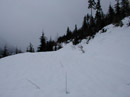
Especially one with no summer trail. This was combination of logging roads
and straight up the fall line climbing. The previous reports I have read were
for routes up the eastern ridge. Our route turned out to make the final ascent
up from the south. This was a Mountaineer winter scramble. I had done a previous
trip led by Richard and Lynn and had such a good time I signed up for another.
We started near the railroad ventilation facility located about a mile east
of the Stevens Pass Nordic Center. There was a wide enough plowed area on
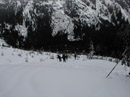
the north side of the highway for our 5 cars and room left over. We crossed
the highway and walked a short distance (actually we walked a long distance
before realizing we went too far) to a logging road. The road goes left and
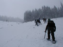
gently gains elevation. At the first switchback we went straight uphill and
met the road again. The road continues heading easterly until it switchbacks
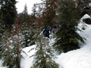
again. Here we once again headed straight up through a clearcut. With some
nice route finding we avoided any postholing. The route started at about
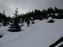
2800'. This clearcut gained about 400', bringing us up to 3800'. We again
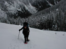
met up with the road and headed east once again. after several more switchbacks
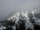
the road ended at the base of a very large and very steep clearcut. The snow
conditions were good and we had little trouble ascending the slope. We stayed
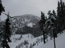
to the far right of the clearcut and entered trees part way up. Just before
entering the forest I finally saw the summit of Arrowhead in the clouds.
At about 4900' the route flattened out in deep forest. We then dropped down
a short way and reached the base of the ridge which runs southwest from the
summit of Arrowhead and on to Jim Hill Mountain.
This next section was the steepest of the day. Grabbing onto small trees was necessary in a number of places. My snowshoe crampons gave enough grip to provide some comfort but I was not looking forward to descending this slope. After what seemed like a long long time we topped out on the ridge at about 5400'. In the morning it was cloudy with some light snow. Now the clouds had broken above us and it was bright sunshine. Far below us to the east on the ridge was the valley of Whitepine Creek. The Chiwaukum Mountains were on the other side of the valley. We had a bit of a debate as to which was Snowgrass and which was Big Chiwaukum Mountain. The ridge rose a bit then descended to a saddle below the summit of Arrowhead. This ridge walk was one of the highlights of the day. The saddle was at about 5300', leaving one last climb of 700' to the summit of Arrowhead at 6030'. The final ridge was a little steep but no problem for everyone in our group. The wind was picking up high on the mountain. I had put on a coat even with the sunshine. At the top the view was much better than I had expected we would have. Some clouds were at the top of Rock, Howard, and Mastiff to the north but many peaks were clear. The weather did not look as good back at the Cascade crest. We started at about 9:30 and I reached the summit at 1:00. By dropping down a little on the east ridge we were able to eat lunch out of most of the wind. The smaller trees on the summit were bright white with a coating of frozen snow. It was quite beautiful.
The trek down to the saddle went very quickly. I was comfortable descending with snowshoes and poles. At the saddle we decided that this would have been a better place to have ascended to. It looked quite a bit less steep than where we ascended the ridge. We retraced our ridge walk and took off our snowshoes. I put away the snowshoes and poles and descended the ridge with boots and my ice axe. As is often the case it was not nearly as tough as I thought it would be. At the bottom the snowshoes and poles came back out. The rest of the descent was fine. Descending steep slopes on snowshoes where 11 people had gone up and down made for a bit of rough footing but all in all it was fine. We reached the highway at 4:00. With no trail to follow I estimate the distance at 8 miles with 3300' of elevation gain. It took 3 1/2 hours up and about 2:20 down. A fun challenging route, a nice summit, better than expected weather, and good company led to another outstanding day in the mountains.
Click on thumbnails to see larger pictures.
Photo Page 2
Home
This next section was the steepest of the day. Grabbing onto small trees was necessary in a number of places. My snowshoe crampons gave enough grip to provide some comfort but I was not looking forward to descending this slope. After what seemed like a long long time we topped out on the ridge at about 5400'. In the morning it was cloudy with some light snow. Now the clouds had broken above us and it was bright sunshine. Far below us to the east on the ridge was the valley of Whitepine Creek. The Chiwaukum Mountains were on the other side of the valley. We had a bit of a debate as to which was Snowgrass and which was Big Chiwaukum Mountain. The ridge rose a bit then descended to a saddle below the summit of Arrowhead. This ridge walk was one of the highlights of the day. The saddle was at about 5300', leaving one last climb of 700' to the summit of Arrowhead at 6030'. The final ridge was a little steep but no problem for everyone in our group. The wind was picking up high on the mountain. I had put on a coat even with the sunshine. At the top the view was much better than I had expected we would have. Some clouds were at the top of Rock, Howard, and Mastiff to the north but many peaks were clear. The weather did not look as good back at the Cascade crest. We started at about 9:30 and I reached the summit at 1:00. By dropping down a little on the east ridge we were able to eat lunch out of most of the wind. The smaller trees on the summit were bright white with a coating of frozen snow. It was quite beautiful.
The trek down to the saddle went very quickly. I was comfortable descending with snowshoes and poles. At the saddle we decided that this would have been a better place to have ascended to. It looked quite a bit less steep than where we ascended the ridge. We retraced our ridge walk and took off our snowshoes. I put away the snowshoes and poles and descended the ridge with boots and my ice axe. As is often the case it was not nearly as tough as I thought it would be. At the bottom the snowshoes and poles came back out. The rest of the descent was fine. Descending steep slopes on snowshoes where 11 people had gone up and down made for a bit of rough footing but all in all it was fine. We reached the highway at 4:00. With no trail to follow I estimate the distance at 8 miles with 3300' of elevation gain. It took 3 1/2 hours up and about 2:20 down. A fun challenging route, a nice summit, better than expected weather, and good company led to another outstanding day in the mountains.
The Logging Road |
First Clearcut |
North of Highway 2 |
Middle First Clearcut |
First Clearcut Top |
Biggest Clearcut |
Part Way Up |
Arrowhead Mt. |
Photo Page 2
Home