1-19-03
Located between Arlington and Darrington,
Boulder River is one ot the best low elevation river hikes in the state.
It has waterfalls, a roaring river, and huge trees. This Winter it can be
hiked in January with no snow at all. This was a Mountaineer trip. We had
only 8 hikers, a nice small number for a group trip. The start was a little
later than I'm used to, at almost 10:30, but plenty early to get parking
spots this day. The lot is not large and finding a space in the Summer can
be a problem. It had been 8 years since my last trip here and I was well overdue
for a return.
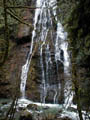
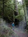
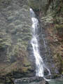
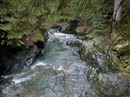
The way starts off on an old road with a steep drop off. Before long the river can be heard then seen below. I was not expecting much water over the various falls but was pleasantly surprised by the torrents. The second falls is the best and it was in great form. The falls are not along the river but are over the far wall of the gorge down to the river. The canyon along here is both deep and narrow, amplifying the sound. The gorge also made logging difficult and the old growth trees alone would make this a "must do" hike. Since this is an easy hike, we were in no hurry. We took many breaks to admire the river, falls, and trees. This is also a virtual rain forest. Moss hangs from the trees and green blankets everything. The trail is in good shape overall. There are a number of long log bridges where the top was cut flat. These are very slick and some care must be exercised. Only one had a hand rail. There is mud but much less than I remember from my last trip here.
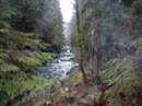
At four miles we reached the end of the trail at the river. There is plastic tape on each side marking what is likely the continuation of the trail on the other side. At one time this trail continued on to Tupso Pass, Goat Flats, and Three Fingers. Since the road to the pass went in there is no longer any reason to ford the river and continue on. I would like to come back sometime and see what is left of the old trail. The day was over cast but remained dry. We had a nice lunch at the trail end before heading back. Several groups left ahead of us but we saw nobody on the way in. On the way out the crowds picked up. I guess 10:30 isn't a late start for most hikers in January. The trail is 8 miles round trip and has about 1000' of elevation gain with ups and downs. This was a very nice day for a low elevation hike in the woods. The company was good and the trail was as beautiful as I remembered.
Click on thumbnails to get larger pictures.
Photo Page 2
Home
The way starts off on an old road with a steep drop off. Before long the river can be heard then seen below. I was not expecting much water over the various falls but was pleasantly surprised by the torrents. The second falls is the best and it was in great form. The falls are not along the river but are over the far wall of the gorge down to the river. The canyon along here is both deep and narrow, amplifying the sound. The gorge also made logging difficult and the old growth trees alone would make this a "must do" hike. Since this is an easy hike, we were in no hurry. We took many breaks to admire the river, falls, and trees. This is also a virtual rain forest. Moss hangs from the trees and green blankets everything. The trail is in good shape overall. There are a number of long log bridges where the top was cut flat. These are very slick and some care must be exercised. Only one had a hand rail. There is mud but much less than I remember from my last trip here.
At four miles we reached the end of the trail at the river. There is plastic tape on each side marking what is likely the continuation of the trail on the other side. At one time this trail continued on to Tupso Pass, Goat Flats, and Three Fingers. Since the road to the pass went in there is no longer any reason to ford the river and continue on. I would like to come back sometime and see what is left of the old trail. The day was over cast but remained dry. We had a nice lunch at the trail end before heading back. Several groups left ahead of us but we saw nobody on the way in. On the way out the crowds picked up. I guess 10:30 isn't a late start for most hikers in January. The trail is 8 miles round trip and has about 1000' of elevation gain with ups and downs. This was a very nice day for a low elevation hike in the woods. The company was good and the trail was as beautiful as I remembered.
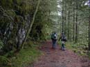
Trail |
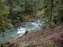
Boulder River |
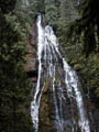
Big Falls |
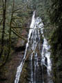
Falls Again |
Bottom of Falls |
Jay |
Last Falls |
Narrow Gorge |
River |
Photo Page 2
Home