4-26-03
Goat lake has always been an early
season favorite of mine. With an elevation of only 3162' at the lake the
trail usually melts out early. I was amazed to see that it had been 8 years
since my last visit. One of the highlights of the day was the drive up the
Mountain Loop Highway. Not only was there no traffic, there was Skunk Cabbage
in full bloom all along the road. The largest fields were near Big Four. Barlow
Pass was completely melted out. The road down to Elliot Creek is in very
good shape. The road up to the trailhead is also in good shape. There are
a few mud puddles but nothing an average passenger car can't handle. I was
very surprised to reach the trailhead just before 9:30 and to be the first
car there. The Doppler Radar showed no rain north of Stevens Pass but it
drizzled from Granite Falls to Big Four. At the trailhead there was no rain
at all. I guess the poor looking weather kept some hikers at home.
When I first started hiking to Goat Lake the trail was the old puncheon road built by the miners at the turn of the last century. That trail followed along Elliot Creek most of the way. When the forest service got tired of maintaining the trail, including a section through a clear cut which became an overgrown thicket, they switched the trail to the abandoned logging road. The road was OK but I much preferred the creek trail. My last hike on along the creek was about 12 years ago. I hiked up the road and took what remained of the old trail back. The trail through the forest was still in good shape. The bushwack across the clear cut was very nasty. I was cut to ribbons and had not tried that trail again. On my last trip in 1995 there was a side trail 1/3 of a mile or so up the road/trail which was the start of the rebuilt creek trail though it was not yet open. This day I expected to hike up to this side trail to access the creek trail. I was surprised to see that the Elliot Creek trail once again starts at the parking lot.
The trail starts out by switchbacking down to the creek. The creek is large and loud with the Spring melt. A short way along the trail leaves the old puncheon road and begins to climb. On the way back I turned onto the old route to see why the detour was built. The old route seems to have collapsed into the creek. Now it's time for my complaints. For the next half mile the trail is massively overbuilt. Gravel has been put down where it is not needed. One section of "trail" has been built up about 3 to 8 feet on wooden supports. This is a rain forest and the wood will eventually rot and the whole 100+ foot long monster will collapse. This must have taken a huge amount of time and money to build. One creek is 1 foot wide. There is an old rotted bridge about 15 feet long spanning the creek and a little muddy spot. The new bridge is right next to the old. It is 50 feet long. Why was this monster built. The overall feel is of a highway not a trail. Just when I was despairing of the damage done to a great old trail it all stopped. I guess the trail builders got tired of lugging heavy beams and they stopped overbuilding. The rest of the new/old trail is a delight. It looks like a plain old trail. No more gravel, no more bridges spanning 8 inch wide creeks. I thoroughly enjoyed a beautiful walk through a dark green forest along a roaring creek. At the end of the forest the trail enters the clear cut. The trail has been brushed thoroughly. I had no trouble at all on this stretch. The old trail through this section met up with the logging road at the end of the old parking lot. At one time this hike was only about 4 miles round trip. When the wilderness was established the road was gated and then was the main route to the lake. Instead of meeting the upper trail at the old spot, the creek trail met the upper trial just before the old parking lot. This saved having to brush out another 1/4 mile of clear cut. The old parking lot is now completely covered with deciduous trees. Without their leaves it was like a forest of tall skinny poles. Shortly the leaves will appear and this will be a dense deciduous forest.
After leaving the parking lot the trail soon enters evergreen forest again. This last section is one of my favorite forest walks. Some of the trees are huge. Right at the wilderness boundary are three monsters. I took a photo to compare my hiking pole to the tree. The pole is 4 1/2 feet long and it would take several of them to reach across the diameter of that tree. On the last switchback to the left before the lake I headed over to see the falls. This is a terrific waterfall. The noise was almost deafening. I climbed down onto large slabs near the base to get a photo. After that it was a short distance to the lake. It had not rained all morning but the clouds were low above the lake. There were only a few small snow patches left. The trail to and along the lake is snow free. Part way along the lake I stopped at my usual spot. Although the lake is high there is one spot with some gravely beach. A big tree overhangs above and makes for a dry spot when it rains. I reached the lake at 11:30 and it was a chilly 43 degrees. The upper half of Foggy Peak was still in the clouds. I had lunch and sat back to read for awhile. A few short flurries of hail came down but I was dry under the tree. After about an hour the clouds lifted over Foggy Peak. I had a great view of the lake and the peak behind. A little sun shone on the peak and 2 big and loud avalanches came down. A couple of hikers dropped down to my lake side spot to do some fishing. They mentioned some good luck fishing there before. After an hour and a half at the lake I headed back. I saw another party near the outlet of the lake though I don't think they saw me. Back down at the old parking lot I saw another group of three. That was it for the day. On a Saturday in late April with no snow on the trail I saw a total of 3 other groups. That alone made this a great day. I took the creek trail back as I much prefer it to the old road, especially with the high water of Spring. While I feel that the new trail is overbuilt in some sections it is a nice addition to the existing road walk. I'll have to get back here again soon. The totals for the day were about 10 miles with 1400' gained.
Click on thumbnails to get larger pictures.
Photo Page 2
Home
When I first started hiking to Goat Lake the trail was the old puncheon road built by the miners at the turn of the last century. That trail followed along Elliot Creek most of the way. When the forest service got tired of maintaining the trail, including a section through a clear cut which became an overgrown thicket, they switched the trail to the abandoned logging road. The road was OK but I much preferred the creek trail. My last hike on along the creek was about 12 years ago. I hiked up the road and took what remained of the old trail back. The trail through the forest was still in good shape. The bushwack across the clear cut was very nasty. I was cut to ribbons and had not tried that trail again. On my last trip in 1995 there was a side trail 1/3 of a mile or so up the road/trail which was the start of the rebuilt creek trail though it was not yet open. This day I expected to hike up to this side trail to access the creek trail. I was surprised to see that the Elliot Creek trail once again starts at the parking lot.
The trail starts out by switchbacking down to the creek. The creek is large and loud with the Spring melt. A short way along the trail leaves the old puncheon road and begins to climb. On the way back I turned onto the old route to see why the detour was built. The old route seems to have collapsed into the creek. Now it's time for my complaints. For the next half mile the trail is massively overbuilt. Gravel has been put down where it is not needed. One section of "trail" has been built up about 3 to 8 feet on wooden supports. This is a rain forest and the wood will eventually rot and the whole 100+ foot long monster will collapse. This must have taken a huge amount of time and money to build. One creek is 1 foot wide. There is an old rotted bridge about 15 feet long spanning the creek and a little muddy spot. The new bridge is right next to the old. It is 50 feet long. Why was this monster built. The overall feel is of a highway not a trail. Just when I was despairing of the damage done to a great old trail it all stopped. I guess the trail builders got tired of lugging heavy beams and they stopped overbuilding. The rest of the new/old trail is a delight. It looks like a plain old trail. No more gravel, no more bridges spanning 8 inch wide creeks. I thoroughly enjoyed a beautiful walk through a dark green forest along a roaring creek. At the end of the forest the trail enters the clear cut. The trail has been brushed thoroughly. I had no trouble at all on this stretch. The old trail through this section met up with the logging road at the end of the old parking lot. At one time this hike was only about 4 miles round trip. When the wilderness was established the road was gated and then was the main route to the lake. Instead of meeting the upper trail at the old spot, the creek trail met the upper trial just before the old parking lot. This saved having to brush out another 1/4 mile of clear cut. The old parking lot is now completely covered with deciduous trees. Without their leaves it was like a forest of tall skinny poles. Shortly the leaves will appear and this will be a dense deciduous forest.
After leaving the parking lot the trail soon enters evergreen forest again. This last section is one of my favorite forest walks. Some of the trees are huge. Right at the wilderness boundary are three monsters. I took a photo to compare my hiking pole to the tree. The pole is 4 1/2 feet long and it would take several of them to reach across the diameter of that tree. On the last switchback to the left before the lake I headed over to see the falls. This is a terrific waterfall. The noise was almost deafening. I climbed down onto large slabs near the base to get a photo. After that it was a short distance to the lake. It had not rained all morning but the clouds were low above the lake. There were only a few small snow patches left. The trail to and along the lake is snow free. Part way along the lake I stopped at my usual spot. Although the lake is high there is one spot with some gravely beach. A big tree overhangs above and makes for a dry spot when it rains. I reached the lake at 11:30 and it was a chilly 43 degrees. The upper half of Foggy Peak was still in the clouds. I had lunch and sat back to read for awhile. A few short flurries of hail came down but I was dry under the tree. After about an hour the clouds lifted over Foggy Peak. I had a great view of the lake and the peak behind. A little sun shone on the peak and 2 big and loud avalanches came down. A couple of hikers dropped down to my lake side spot to do some fishing. They mentioned some good luck fishing there before. After an hour and a half at the lake I headed back. I saw another party near the outlet of the lake though I don't think they saw me. Back down at the old parking lot I saw another group of three. That was it for the day. On a Saturday in late April with no snow on the trail I saw a total of 3 other groups. That alone made this a great day. I took the creek trail back as I much prefer it to the old road, especially with the high water of Spring. While I feel that the new trail is overbuilt in some sections it is a nice addition to the existing road walk. I'll have to get back here again soon. The totals for the day were about 10 miles with 1400' gained.
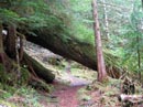
Down Tree |
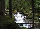
Creek View |
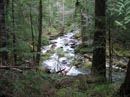
More Creek |
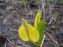
Skunk Cabbage |
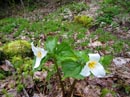
Trillium |
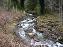
Elliot Creek |
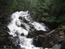
Big Falls |
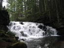
Smaller Falls |
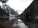
Low Clouds |
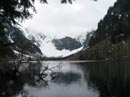
Clouds Rising |
Photo Page 2
Home