6-15-03
I have done the Johnson
Creek to
Medra Pass and Malcolm Mountain loop trip twice before. When I found
out the
Mountaineers were doing Malcolm Mountain I suggested doing the loop.
Thanks to a hearty group of hikers we pulled it off and I think we all
had a good time. This route goes on good trail, poor trail, and at
times no trail.
The old sheep driveway along the ridge is in poor shape. This means the
route requires a little route finding and a taste for traveling on a
sometimes
sketchy trail. The payoff is a lot of ridge walking with very nice
views.
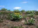
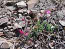
This early in the year there were also a nice variety of flowers.
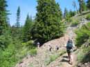
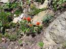
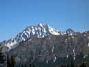
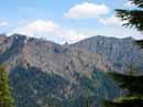
We met at Twenty Nine Pines campgrounds and continued to the Johnson Creek trailhead located near Beverly campgrounds. We were on the trail by about 9:40. It was sunny but thankfully not a blistering east side day. The trail starts out fairly level as it follows Johnson Creek. At 3/4 mile we reached the Jungle Creek intersection. This would be our return route. The trail crosses the creek 6 or 8 times. The creek is now low enough to make it possible to accomplish all the crossings with dry feet. There is a little rock hopping needed but it's not bad. This is a motorcycle trail and is in quite good shape. We met one cycle at the ridge top and that was all. The lower valley was covered with a variety of flowers including, Vanilla Leaf, False Solomon's Seal, Yellow Violets, Indian Paintbrush, Strawberries, and many more. The trail finally leaves the creek and begins to ascend. The thick forest gives way to more open slopes. It was a bit dusty thanks to the motorcycles tearing up the soil. One tree was down and motorcycles have gone up the hillside to get around it. They have badly churned up the slope. Hikers can easily step over the log. Higher up we began to get glimpses of Mt. Stuart and Ingalls Peak. We traversed over to Medra Pass and took a break. There was a small snow patch just below the pass that was just off the trail. Otherwise, the north facing slope is completely snow free. Be the time we reached the pass it was nearly 11:30 and time for a food break. From the pass a trail heads north along the ridge towards Koppen Mountain. We turned left and headed south. In a short distance there is a spit. The right path heads down Medra Creek. We went left and stayed on the ridge top.
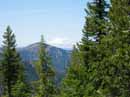
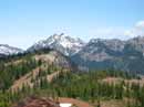
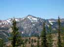
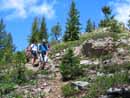
The trail has a number of ups and downs. Sometimes it is directly on the ridge and sometimes below to the right. We could see Malcolm Mountain from much of the way along the ridge. In some places the trail is very sketchy as it crosses loose scree. It is not a difficult scramble but some trail hikers will not like it. I lost the trail several times but it always remains near the ridge top. The only trick is to make sure you leave the ridge and drop down on a ridge connecting to Malcolm Mountain. It became very overgrown here and dropping down sooner would have been easier. We slogged through some thick bushes and then worked our way down. On the connector ridge we again picked up the route. After dropping about 300' we started up the ridge towards Malcolm. This is more nice ridge climbing with a good view over to Johnson Mountain. Part way up the ridge the old sheep driveway we were following traverses across the open slope on a really sketchy route. There is not much traction on that section of trail. We continued straight up. The way eases soon and multiple trails continue in forest towards Malcolm. By now some of the group must have been wondering just what they had gotten themselves into. There is a hunters camp in the forest and soon after the way breaks out into the open. We climbed a short distance up to the ridge crest and stopped for lunch. The summit of Malcolm is visible a short distance away. The views very very good here. Ingalls, Stuart, and Earl Peaks were to the north.
After eating we took a vote and 5 of us decided to continue to the summit while the others relaxed in the sun. The trail dropped down a bit then began to contour around Malcolm. The trail does go around the peak then up to the summit on the back side. It is in such bad shape that it is more difficult than just scrambling straight up the ridge. That is exactly what we did. It is a little steep but not long. There is forest almost all the way and no exposure. The view from the top is really quite good. Malcolm is only about 5460' but sits a good distance from any other Teanaway peak. Most of the Stuart Range is visible form the summit. We didn't stay long. It only took about 12 minutes to go up and less than 10 minutes to get back to the group. We soon were packed up and heading on. While there are a number of trails that go up Malcolm I always come down the same way. The obvious trail goes to the right side of the ridge running from Malcolm to Johnson Mountain. The sheep driveway goes to the left of the ridge. The trail we took down does not show on any maps but is in much better shape than the one that does. After switchbacking down the trail traverses across an open slope to meet the top of the descending ridge. It is not as sketchy as the driveway on the other side of the ridge but it will scare some hikers. Every one in our group made it across in good shape. Once on the ridge it is more sketchy trail with several steep ups and downs. After about a mile of this we reached the other end of the ridge at the base of Johnson Mountain. The Way Creek Trail descends to the Jungle Creek Road from here. I was here a few weeks ago climbing Johnson. There was snow then but it is all gone now. From this point on back the way is on real honest to goodness trail. I'm sure the group was very happy to see it. The rest of the way down is also in cool forest. The day was warm and the shade was nice. In one mile we reached the intersection on the ridge top. Right is down to the Jungle Creek Road on the Jungle Creek Trail. Left is down and back to our starting place. At first the trail switchbacks down to the valley floor. From there out the way is very flat. There are 3 more creek crossings and all were very easy. At long last we reached Johnson Creek and completed our loop. We retraced the last 3/4 mile and were back at the trailhead. Some of our party may have had a bit more of a scramble than they expected. All of the group members handled it well. It was a day full of flowers, views, and ridge walking. I hope everyone else had as good a time as I had. We saw one motorcycler and three hikers for the day. The totals on the day were about 12 miles and 3100' gained.
Click on thumbnails to get larger pictures.
Photo Page 2
Home
We met at Twenty Nine Pines campgrounds and continued to the Johnson Creek trailhead located near Beverly campgrounds. We were on the trail by about 9:40. It was sunny but thankfully not a blistering east side day. The trail starts out fairly level as it follows Johnson Creek. At 3/4 mile we reached the Jungle Creek intersection. This would be our return route. The trail crosses the creek 6 or 8 times. The creek is now low enough to make it possible to accomplish all the crossings with dry feet. There is a little rock hopping needed but it's not bad. This is a motorcycle trail and is in quite good shape. We met one cycle at the ridge top and that was all. The lower valley was covered with a variety of flowers including, Vanilla Leaf, False Solomon's Seal, Yellow Violets, Indian Paintbrush, Strawberries, and many more. The trail finally leaves the creek and begins to ascend. The thick forest gives way to more open slopes. It was a bit dusty thanks to the motorcycles tearing up the soil. One tree was down and motorcycles have gone up the hillside to get around it. They have badly churned up the slope. Hikers can easily step over the log. Higher up we began to get glimpses of Mt. Stuart and Ingalls Peak. We traversed over to Medra Pass and took a break. There was a small snow patch just below the pass that was just off the trail. Otherwise, the north facing slope is completely snow free. Be the time we reached the pass it was nearly 11:30 and time for a food break. From the pass a trail heads north along the ridge towards Koppen Mountain. We turned left and headed south. In a short distance there is a spit. The right path heads down Medra Creek. We went left and stayed on the ridge top.
The trail has a number of ups and downs. Sometimes it is directly on the ridge and sometimes below to the right. We could see Malcolm Mountain from much of the way along the ridge. In some places the trail is very sketchy as it crosses loose scree. It is not a difficult scramble but some trail hikers will not like it. I lost the trail several times but it always remains near the ridge top. The only trick is to make sure you leave the ridge and drop down on a ridge connecting to Malcolm Mountain. It became very overgrown here and dropping down sooner would have been easier. We slogged through some thick bushes and then worked our way down. On the connector ridge we again picked up the route. After dropping about 300' we started up the ridge towards Malcolm. This is more nice ridge climbing with a good view over to Johnson Mountain. Part way up the ridge the old sheep driveway we were following traverses across the open slope on a really sketchy route. There is not much traction on that section of trail. We continued straight up. The way eases soon and multiple trails continue in forest towards Malcolm. By now some of the group must have been wondering just what they had gotten themselves into. There is a hunters camp in the forest and soon after the way breaks out into the open. We climbed a short distance up to the ridge crest and stopped for lunch. The summit of Malcolm is visible a short distance away. The views very very good here. Ingalls, Stuart, and Earl Peaks were to the north.
After eating we took a vote and 5 of us decided to continue to the summit while the others relaxed in the sun. The trail dropped down a bit then began to contour around Malcolm. The trail does go around the peak then up to the summit on the back side. It is in such bad shape that it is more difficult than just scrambling straight up the ridge. That is exactly what we did. It is a little steep but not long. There is forest almost all the way and no exposure. The view from the top is really quite good. Malcolm is only about 5460' but sits a good distance from any other Teanaway peak. Most of the Stuart Range is visible form the summit. We didn't stay long. It only took about 12 minutes to go up and less than 10 minutes to get back to the group. We soon were packed up and heading on. While there are a number of trails that go up Malcolm I always come down the same way. The obvious trail goes to the right side of the ridge running from Malcolm to Johnson Mountain. The sheep driveway goes to the left of the ridge. The trail we took down does not show on any maps but is in much better shape than the one that does. After switchbacking down the trail traverses across an open slope to meet the top of the descending ridge. It is not as sketchy as the driveway on the other side of the ridge but it will scare some hikers. Every one in our group made it across in good shape. Once on the ridge it is more sketchy trail with several steep ups and downs. After about a mile of this we reached the other end of the ridge at the base of Johnson Mountain. The Way Creek Trail descends to the Jungle Creek Road from here. I was here a few weeks ago climbing Johnson. There was snow then but it is all gone now. From this point on back the way is on real honest to goodness trail. I'm sure the group was very happy to see it. The rest of the way down is also in cool forest. The day was warm and the shade was nice. In one mile we reached the intersection on the ridge top. Right is down to the Jungle Creek Road on the Jungle Creek Trail. Left is down and back to our starting place. At first the trail switchbacks down to the valley floor. From there out the way is very flat. There are 3 more creek crossings and all were very easy. At long last we reached Johnson Creek and completed our loop. We retraced the last 3/4 mile and were back at the trailhead. Some of our party may have had a bit more of a scramble than they expected. All of the group members handled it well. It was a day full of flowers, views, and ridge walking. I hope everyone else had as good a time as I had. We saw one motorcycler and three hikers for the day. The totals on the day were about 12 miles and 3100' gained.
Out Of The Valley |
Paintbrush |
Mt. Stuart |
Mt. Rainier |
Balsamroot |
Volcanic Neck |
Esmerelda Peaks |
Middle Fork Peak |
Ridge Route |
Penstemon |
Photo Page 2
Home