12-20-03
I wanted to get in a long trip
without forests of downed trees or getting rained on while slogging through
the snow. That ruled out most possible trips. With a 4000' snow level and
sporadic rain forecast it seemed bleak. Add in all the downed trees from
the recent wind storm and I had few choices. I'm not a huge fan of road
walks but West Rattlesnake Mountain presented the best opportunity for
a long hike. I turned off I-90 onto Highway 18 and quickly turned left and
parked. It was 9:20 when I got started. Each time I have been here the gate
has been locked. Today it was open. Not a good sign. I didn't want to share
the road with cars and trucks. Still, I was there so off I went. The first
change was that the initial part of the road is now paved. The road soon
reverted to dirt. By the time I reached the electric station in less than
a mile two trucks had already passed me. The second one had a tree in the
back so I guess they leave the gate open for Christmas tree hunters. The
second gate was also open. My fears did prove to be overstated. I saw one
bicycle and another truck in the last mile coming out. Otherwise, I was all
alone for the day.
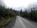
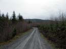
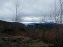
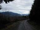
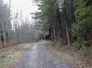
The road is flat for the first 2 1/4 miles. It crosses Canyon Creek and finally begins to climb. At 3 1/2 miles a road turns off left and I continued straight ahead. At 4 3/4 miles a road turned off left again. It was well maintained but not as well as the one I was on. I couldn't remember which way to go. One time years ago while looking for the correct road to West Rattlesnake I took a wrong turn and made it all the way to just below East Rattlesnake. I took the most used road straight ahead and began to climb again. After a little more than half a mile I knew I was on the wrong track. Still, I did get some nice views of the mountains to the southeast. I headed back downhill to the intersection and this time took the other road. There were several cut up trees along this section and one which must have recently fallen. It was easy to step over but would impede a vehicle. It had been overcast the whole day and a little mist fell but not enough to require rain gear. This is a long trip and my detour had me concerned if I would make it to the top. If I was going to make it then there would have to be very little snow to slow me down. By the 6 mile point the road was still bare.
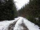
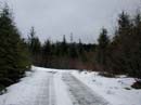
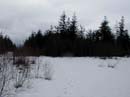
After turning onto this road the esthetics improved. The road is narrower and there is forest instead of clearcuts. There are mile markers so I had a rough idea of how much farther I had to go. At the seven mile mark I hit snow. It was not deep and had been compressed by a the tracks of a bulldozer or snowcat. It was slick and wet. My progress slowed as I slogged along. The snow disappeared for awhile and I sped up. Soon it returned. I was surprised to now see one set of boot prints going down. After rounding a turn I found the old Rattlesnake Mountain Trail heading off into the woods. There were no footprints there. The snow deepened and the mist returned and increased. I turned off the road onto untouched snow. Another turn led to the final climb to Grand Prospect. Footprints came out of the woods here. The upper Rattlesnake Mountain Trail has been rerouted off of the road since my last visit. At Grand Prospect it was dark and cloudy but I could see North Bend and Mt. Si clearly. Mt. Teneriffe was in the clouds. The mist now turned into rain and I pulled out my umbrella. I also put on gaiters as the snow was now a foot deep and soft. The last section is a straight up route gaining 100' to the top. I stopped for a quick lunch and put on more clothes. The deepest snow, about 18 inches, was here. It was chilly at 38 degrees but not really cold.
When I dropped down to the viewpoint at Grand Prospect the view was gone. Mt. Si and North Bend had disappeared. The way down was long but easy. The tough part was the pounding of my feet. The last few miles were the toughest as my heels hurt. That pavement did not help. I reached my car at 3:10. With the detour it was 9 miles up and 8 miles down with 2900' of gain. As it turned out, I had my long hike with little snow, no trees down, and near total solitude. Not a bad way to spend a damp December day.
Click on thumbnails to get larger pictures.
Photo Page 2
The road is flat for the first 2 1/4 miles. It crosses Canyon Creek and finally begins to climb. At 3 1/2 miles a road turns off left and I continued straight ahead. At 4 3/4 miles a road turned off left again. It was well maintained but not as well as the one I was on. I couldn't remember which way to go. One time years ago while looking for the correct road to West Rattlesnake I took a wrong turn and made it all the way to just below East Rattlesnake. I took the most used road straight ahead and began to climb again. After a little more than half a mile I knew I was on the wrong track. Still, I did get some nice views of the mountains to the southeast. I headed back downhill to the intersection and this time took the other road. There were several cut up trees along this section and one which must have recently fallen. It was easy to step over but would impede a vehicle. It had been overcast the whole day and a little mist fell but not enough to require rain gear. This is a long trip and my detour had me concerned if I would make it to the top. If I was going to make it then there would have to be very little snow to slow me down. By the 6 mile point the road was still bare.
After turning onto this road the esthetics improved. The road is narrower and there is forest instead of clearcuts. There are mile markers so I had a rough idea of how much farther I had to go. At the seven mile mark I hit snow. It was not deep and had been compressed by a the tracks of a bulldozer or snowcat. It was slick and wet. My progress slowed as I slogged along. The snow disappeared for awhile and I sped up. Soon it returned. I was surprised to now see one set of boot prints going down. After rounding a turn I found the old Rattlesnake Mountain Trail heading off into the woods. There were no footprints there. The snow deepened and the mist returned and increased. I turned off the road onto untouched snow. Another turn led to the final climb to Grand Prospect. Footprints came out of the woods here. The upper Rattlesnake Mountain Trail has been rerouted off of the road since my last visit. At Grand Prospect it was dark and cloudy but I could see North Bend and Mt. Si clearly. Mt. Teneriffe was in the clouds. The mist now turned into rain and I pulled out my umbrella. I also put on gaiters as the snow was now a foot deep and soft. The last section is a straight up route gaining 100' to the top. I stopped for a quick lunch and put on more clothes. The deepest snow, about 18 inches, was here. It was chilly at 38 degrees but not really cold.
When I dropped down to the viewpoint at Grand Prospect the view was gone. Mt. Si and North Bend had disappeared. The way down was long but easy. The tough part was the pounding of my feet. The last few miles were the toughest as my heels hurt. That pavement did not help. I reached my car at 3:10. With the detour it was 9 miles up and 8 miles down with 2900' of gain. As it turned out, I had my long hike with little snow, no trees down, and near total solitude. Not a bad way to spend a damp December day.
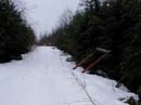
Road At Mile 2 |
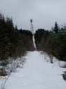
Summit Tower |
Cascades View |
Taylor Mt. |
Final Road |
Snow Begins |
Tower View |
Untouched Snow |
Nearing Top |
Boot Tracks |
Photo Page 2