9/04-07/04
Hiking in the Goat Rocks Wilderness
had been on my agenda for years. It was just too far for a day hike and
I never could put together a backpacking trip. For this Labor Day weekend
Gary, Mark, and I had planned on a Spider Gap, Image Lake, Buck Creek Pass
loop. Last minute weather changes left the south Cascades looking much better
than the north so we dusted off an old plan of Gary's in the Goat Rocks.
This suited me just fine as I would finally get to hike there. A true trail
loop did not exist so we would have to do some bushwhacking. Our plan called
for the off trail work at the start then trail nearly all the rest of the
way. One short bushwhack could be done at the end to save a mile or so. We
also pushed the time frame back a day for better weather. The new plan was
for a Saturday through Tuesday trip.
Day 1:
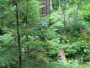
Mark and I met at Gary's at 7:30 and we reached the Lily Basin trailhead near Packwood at about 10:30. We didn't know if the road continued on or was closed down. The road was open and we continued on for another 2 1/2 miles to the end on the crest of Snyder Mountain at 4800'. At one time a trail branched off from near the beginning of the Lily Basin Trail and dropped down to the Packwood Lake Trail. Much of the route had since been clear cut but we had the old route on a map and hoped to be able to find some of it. We found a few hundred feet. The rest has been obliterated. We parked at the end of the road and started off at about 11:00. I brought my GPS and had loaded several waypoints to help with the bushwhack. We needed to go 4 miles losing 1700' to reach the Packwood Lake Trail. The route seemed easy on a map but proved to be a little more difficult. A cat track gave way to clear cut with logs to get over. We began to get well off course until the GPS and map and compass discovered our error. After crashing down through the trees for a little over a mile we intersected another road. We began to get below the thick wet mist. At the end of the road we headed down towards Art Lake. At first we were on a cat track along the ridge but we soon encountered real tread. The tread soon entered a clear cut and disappeared. We headed above the clear cut and began to drop in forest. We found another spur road which took us to Art Lake.
Gary had been there years earlier scouting a route and saw the old trail descending from Art Lake. We were disappointed to see that across from the lake was another huge clear cut. We continued on the road until forest resumed and headed down. The old growth forest here was spectacular. There was also lots of devils club to fight through. We dropped down to discover our road switched back until we hit it again. We crossed and continued down, finally reaching the Packwood Lake Trail at about 3100'. The 4 miles of bushwhacking took us about 3 1/2 hours.
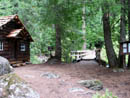
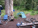
Now on good trail we sped along to Packwood Lake. The trail is nearly flat as we lost 225' to the lake. We passed two groups coming out from the lake and a family at the lake shore. That was almost as many people as we would encounter over the next 3 1/2 days. Packwood Lake is at 2857' and our destination was Lost Lake at 5165', another 3 3/4 miles up the trail. At 2 1/4 miles we reached Mosquito Lake. The nice thing about September is that we had no bugs at all the whole trip. Mosquito Lake would be a good camp spot except that there was a braying mule close by. We continued on. Above Mosquito Lake we reentered the damp dark clouds. At 3 1/4 miles from Packwood Lake we reached the junction with the Coyote Ridge Trail and turned left half a mile to Lost Lake. Boy was it lost. We could not see half way across it through the clouds. There were more than half a dozen empty camps as we chose the best looking one. It was now 7:30 and rapidly getting dark. The tents went up, the food line was hung and we had dinner in the dark. Gary had his first opportunity to use his new Hilleberg Nallo 2. He and Mark were snug and warm inside. I brought My Tarptent Squall. It was my first time to test it in rain.
Stats for the day were 10.6 miles with 2300' gained.
Day 2:
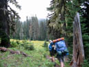
In fact, it rained on and off all night. I stayed nice and dry in my lightweight tarptent. Gary was raving about how much he already liked his Nallo. He seemed to like it more each day. In the morning the clouds began to dissipate and by the time we were ready to head out it was clear. It really is a pretty little lake. We even saw a few fish jumping. Since we only had 7 1/2 miles to cover this day we didn't get started until 11:30. That gave us a chance to dry out the tents before packing and generally lounge around. We climbed up from the lake and quickly met the Coyote Ridge Trail. This is one neat trail. A few days later we were able to look back across the valley and see just how rugged the ridge is. The trail was constructed to fit the terrain not blasted into it. It goes up or down to avoid obstructions. When the slope is impossibly steep it goes all the way to the crest until it can drop down again. The first part is in deep forest with a thick green ground cover. Views occur occasionally where large talus fields are crossed. At one we saw a pika hay pile that was more than a foot tall. Those guys will eat well this winter.
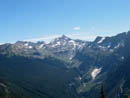
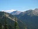
At Beaver Bill Creek was a large flat camp site along the creek. This would be a great place to camp. The creek was lined with Lewis Monkeyflower. All throughout the trip we encountered wildflowers. That was the last thing I expected in September. Pinkish and yellow monkeyflower, paintbrush, a columbine, lupine, western anemone, bistort, and gentian were some of them. Having Mark and Gary along helped significantly in identifying the flowers. After lunch at the campsite the trail became even more interesting. It entered an area of rocks and heather. Farther the views began. We could see out to Elk Pass, our destination, and to Old Snowy down the valley. Hawkeye Peak and Johnson Peak were across from us. The trail climbed from 5150' to a high point of 6400'. Packwood Lake came into view below and Mt. Rainier popped out. As we contoured around we saw several mountain goats above. They would be the first of many goats we would see. As the trail began to drop to Packwood Saddle we reached the bare ridge top. Now views northeast opened towards Mt. Aix and Mt. Stuart. When do I not see Mt. Stuart?
At long last we reached the wooded Packwood Saddle at 5550'. From there is was another 1 1/2 miles gaining 1125' to Elk Pass. Mark stopped to take some photos short of the pass and Gary and I continued on. It was short sleeve weather coming up but a stiff cold breeze met us at the pass. We had hoped to camp at the pass but I did not want to put up my tarptent in such stiff cold winds. There was a snowfield east of the pass that could provide water if melted. The Pacific Crest Trail goes along the ridge to Elk Pass and continues north around a point before dropping down to the east. We decided that dropping down to the meadows below was the best bet for camping and getting running water. It was now 7:30 and darkness was not far away. Gary went back down the trail to tell Mark about our plans and returned. We went around the steep snow field to the north and descended on scree to the meadows below. We found the best spots possible among the heather and rocks for tent sites. Now the wind was blowing down where we were and putting up the tents in near darkness and a strong steady wind was a chore. Gary had no worries sleeping in his bombproof Nallo but I looked forward to sleeping with netting all around my tent.
At that point the clouds came in. It was just like the movie "The Fog". It came out of nowhere and was instantly like thick pea soup. My tent was 20' from Gary's and I couldn't see it. Mark was somewhere 100' above us on the ridge top. He hollered out and I was amazed that he heard my answer yelling into the wind. He could not even see our headlamps through the clouds. With much yelling he somehow dropped down the scree and found us. Water was just a short distance away but finding the tents again required a light for a beacon and some yelling. I have never seen anything like that. We had dinner and by 9:30 when we turned in all the clouds were gone and so was the wind. With no lights of any city the stars were breathtaking.
Stats for the day were 7.5 miles with 2500' gained.
Day 3:
We woke up at about 6:30 with the bright sun coming over the eastern horizon. My pack had a touch of frost on it. We now discovered that the Crest Trail was only a few hundred feet away from us. Everything looked different in broad daylight. After the mist and rain of the first night we had nothing but sunshine for the rest of the trip. Also, after reaching Lost Lake we would not be under 5000' again until the last mile of trail. A walk across the vast meadow gave me a view of Mt. Rainier sitting above a huge sheer rock face. It was beautiful in the early morning light. We had a lot to do this day and we were packed up and hiking by 9:00 am.
First we ascended back to Elk Pass. From Coyote Ridge we were able to see much of the route over to Old Snowy. It is the most improbable trail I have encountered. There is good reason the signs advise great care if you meet a horse party. The narrow route is fine for a hiker but there is precious little room for a horse meeting a hiker. It's like long stretches of a narrower Kendall Katwalk. The day before we had seen a herd of a dozen goats far below in the valley. At this point I saw a single goat just below us. The south side of Old Snowy is mostly bare but the northeast side has plenty of snow. We were now above trees and the rock and snow was very alpine. The trail is not at all dangerous when dry but might be a little exciting if icy. My old hiking guide listed the high point of the Crest Trail as 7600', just below the summit of Old Snowy at 7930'. Consulting maps and looking ahead we discerned that the Crest Trail was rerouted at a much lower elevation. Just after a final low point before Old Snowy we met the intersection. We also met the first person in 24 hours. He had come across the lower route. He mentioned that there was one snow patch that he chose to descend around.
We chose to head up the old trail. The "Cascade Crest Trail" was constructed much differently than the newer "Pacific Crest Trail". It seldom was limited to a 10% grade. The route along Old Snowy was much steeper. Much of it was on talus but was still easy to follow. A few well placed cairns helped. The route topped out on the ridge of Old Snowy at 7600'. Snowgrass Flats was now visible far below. Goat Lake also came into view. We dropped our backpacks, filled daypacks, and headed up the last 330' to the summit. There is a trail all the way up with just some very minor scrambling in one spot. The summit views are outstanding. We saw Ives and Curtis Gilbert close by. Mt. Adams dominated the south along with Mt. St. Helens. Hawkeye and Johnson were to the west. Mt. Rainier was north. We could even see the top of Glacier Peak. This was a great spot for lunch.
We had a long lunch and finally headed down to our packs. The original plan was to follow the Crest Trail to Snowgrass Flats then turn and hike back up to Goat Lake. The trail goes straight south before turning at a lower elevation and going straight north to the lake. From up high we plotted several possible short cuts. Coyote Ridge forms the east wall of the valley of Packwood Lake. Old Snowy is at the end of the valley. A ridge continues across the head of the valley to just above Goat Lake. Hawkeye Point and Johnson Peak are the high points on the western side of the valley. With that in mind, we descended back to our packs and continued down the Cascade Crest Trail. The two trails met on the Old Snowy-Goat Lake ridge.
We decided to follow the ridge to see if a way presented itself to drop down to the Goat Lake Trail. A short way along the rocky ridge was a campsite. It had a rock foot stool and a rock arm chair complete with a 5' tall back rest. I've never seen anything like it. The ridge route seemed to go so we continued down it. In fact there was a faint boot trail for a good distance. When the ridge gave way to a long rock slope we descended to heather and grass and continued down. We refilled water bottles at a creek lined with more monkeyflowers. Here we met a trail which descended rapidly to the Goat Lake Trail. We had only to gain about 150' in a short distance to Goat Lake. This short cut lopped off nearly 2 1/2 miles and 350' of gain. One couple was setting up camp at the lake but we did not get close to them. The lake is fairly barren. It has a huge waterfall coming out of it that we saw for miles while nearing the lake.
We headed up from the lake contouring a grassy hillside with more of the continuous views we were now used to. Volcanos to the south, the crest to the east, and enormous green meadows everywhere. The trail was dotted with more wildflowers as well. We intersected the Goat Ridge Trail and turned right and steeply uphill. This trail headed north until attaining the ridge just below Hawkeye Point at 7000'. Mark continued on towards Heart Lake and Gary and I filled day packs and headed up the short trail over one bump then on to the summit of Hawkeye. There were a few remnants of a lookout site. From 7431' the view was terrific. Goat Lake was 1000' directly below us. Johnson Peak was down the ridge. Our route along the Cascade Crest was just across the valley. Mt. Hood was now peaking our from behind Mt. Adams. We also saw several groups of goats farther along the ridge. They move around the ridges from east to west to stay in the sun as long as possible. Our stay was short as we had several more miles to get to Heart Lake. After dropping down the ridge we again put our backpacks on and headed off. The basin is a long semi circle with Heart Lake below the north side of the valley. We contoured around at a fast pace as once again we were nearing the end of daylight.
High above Heart Lake Gary slammed to a stop and pointed up above us. Numerous bright white dots lined the grassy hillside. We counted about 25 goats. The marmot that ran across the rocks was a minor event compared with the goats. I have seen many goats over the years but never a herd of this size. We watched and took photos for a long time and suddenly realized we needed to take off to reach the lake before dark. A few minutes later we reached a big creek where Mark was watching the goats. He had binoculars and counted a total of 31 goats. Neither Mark nor Gary were excited about dropping down to the lake so we scouted for a high camp. In fact there was an established site just before the creek. It was on a steep promontory with a vertical drop on two sides. We set up camp here and called it a day. The goats bedded down high above us.
Stats on the day: 7.5 miles with 2800' gained.
Day 4:
Our Plan was to scramble up Johnson Peak in the morning and then hike out. We packed our day packs and headed up the grassy slopes on the south side of Johnson. There is an almost continuous cliff band around the peak. We spotted several spots where it looked easy to climb through on rock and grass. Some goats had easily walked up one the night before. That is the one we headed for. The slope steepened but remained easy to ascend. The steepest slope was about 100' high and the grade moderated above. That section proved to be one of the hardest sections I have scrambled. A fall would have been very bad. water oozed out in places to make it slicker. I am not a serious climber and this was right at my limit. Solid rock at that angle would not have been a problem. This stuff was nasty. By slightly different routes all three of us made it up. The next section was steep grass and the grade lessened as we moved higher. The last few hundred feet was just an easy walk up.
I saw Gary above me pointing over the ridge as I reached it. I saw Packwood Lake and shouted "Packwood Lake". Farther left I saw 10 goats that he had been pointing at. Oops... The goats heard me and scampered around the ridge and out of sight. I hope he got a photo before my blunder. The summit provided more great views with the benefit of morning light. We left just after 9:00 am and reached the 7487' summit in about an hour at 10:05. We could now see just how rugged Coyote Ridge really is. It amazed us even more that a trail was routed along it. Packwood Lake sat below us with Mt. Rainier right behind it. Not a cloud marred our views. A careful search proved this to be the only peak I know of where six volcanos are visible. We could see Adams, Hood, St. Helens, Rainier, Glacier Peak, and the tip of Mt. Baker. The Goat Rocks crest is also right in your lap. We had a nice long stay on the summit.
The one thing I was sure of was that I was not going down the route I came up. The others concurred. We headed north along the ridge but it did not look good. To the south was a low saddle with a gentle slope back to our camp. The trick was to get over to it. we dropped part way down on grass and rocks and worked our way to the head of a grassy gully. It appeared to go so down we went. The top was steepest then it began to moderate. A sharp right turn and we had steep but clear sailing. I would never have figured that route out from below. It worked fine and we had no more problems getting back to camp.
After packing up one last time we were on our last leg of the journey. The trail contoured above Heart Lake as the hillside continued to be filled with wildflowers. After the lake turnoff we climbed to a ridge of Johnson where we met the Angry Mountain Trail. Across the ridge the route contoured around the head of Lily Basin. High on Johnson we continued to see more and more goats. The route crossed numerous creeks. This route had plenty of water even in September. Mt. Rainier was in front of us all the way as we traversed through rocks and heather. The trail reached the north side of the valley and moved back and forth across the ridge top. Finally it entered forest for the first time since Packwood Saddle. We motored down the trail as yet another day was rapidly passing by.
We had planned to look for the start of the elusive trail down to Packwood Lake and cut off about a mile of road walk back to the car. From a ridge top viewpoint we could see that the ridge we planned to run had been clear cut all the way to the top where the Wilderness boundary ran. This would make the route that much harder. Still we used map and gps to try to find the turn off. We failed miserably and decided to continue on the Lily Basin Trail. There is a horse lot up a spur road that is shorter so that's how we went. By now we wanted to get home before 10:00 pm so Gary and I, with the lightest packs, ran the last 1+ mile. Gary then dumped his pack and tore off to the car. He made it 2 1/2 miles uphill on the road in high top boots in 30 minutes and drove down to pick us up. With the long drive home I walked through my door at 9:40 pm.
Stats on the day: 8.25 miles with 2400' gained.
Trips totals: 34 miles with 10,000' gained.
This turned out to be a superb four day backpacking trip. Except for the first night we had excellent weather. It was warm but not hot and there were no bugs. The wildflowers were a total surprise. The number of goats was incredible. We met only one person the last two days and three people the last three days. Our timing and route gave us an amazing amount of solitude on a holiday weekend. All in all this rates as one of the best backpacking trips I have ever been on.
Click on thumbnails to get larger pictures.
Photo Page 2
Trips - 2004
Home
Day 1:
Mark and I met at Gary's at 7:30 and we reached the Lily Basin trailhead near Packwood at about 10:30. We didn't know if the road continued on or was closed down. The road was open and we continued on for another 2 1/2 miles to the end on the crest of Snyder Mountain at 4800'. At one time a trail branched off from near the beginning of the Lily Basin Trail and dropped down to the Packwood Lake Trail. Much of the route had since been clear cut but we had the old route on a map and hoped to be able to find some of it. We found a few hundred feet. The rest has been obliterated. We parked at the end of the road and started off at about 11:00. I brought my GPS and had loaded several waypoints to help with the bushwhack. We needed to go 4 miles losing 1700' to reach the Packwood Lake Trail. The route seemed easy on a map but proved to be a little more difficult. A cat track gave way to clear cut with logs to get over. We began to get well off course until the GPS and map and compass discovered our error. After crashing down through the trees for a little over a mile we intersected another road. We began to get below the thick wet mist. At the end of the road we headed down towards Art Lake. At first we were on a cat track along the ridge but we soon encountered real tread. The tread soon entered a clear cut and disappeared. We headed above the clear cut and began to drop in forest. We found another spur road which took us to Art Lake.
Gary had been there years earlier scouting a route and saw the old trail descending from Art Lake. We were disappointed to see that across from the lake was another huge clear cut. We continued on the road until forest resumed and headed down. The old growth forest here was spectacular. There was also lots of devils club to fight through. We dropped down to discover our road switched back until we hit it again. We crossed and continued down, finally reaching the Packwood Lake Trail at about 3100'. The 4 miles of bushwhacking took us about 3 1/2 hours.
Now on good trail we sped along to Packwood Lake. The trail is nearly flat as we lost 225' to the lake. We passed two groups coming out from the lake and a family at the lake shore. That was almost as many people as we would encounter over the next 3 1/2 days. Packwood Lake is at 2857' and our destination was Lost Lake at 5165', another 3 3/4 miles up the trail. At 2 1/4 miles we reached Mosquito Lake. The nice thing about September is that we had no bugs at all the whole trip. Mosquito Lake would be a good camp spot except that there was a braying mule close by. We continued on. Above Mosquito Lake we reentered the damp dark clouds. At 3 1/4 miles from Packwood Lake we reached the junction with the Coyote Ridge Trail and turned left half a mile to Lost Lake. Boy was it lost. We could not see half way across it through the clouds. There were more than half a dozen empty camps as we chose the best looking one. It was now 7:30 and rapidly getting dark. The tents went up, the food line was hung and we had dinner in the dark. Gary had his first opportunity to use his new Hilleberg Nallo 2. He and Mark were snug and warm inside. I brought My Tarptent Squall. It was my first time to test it in rain.
Stats for the day were 10.6 miles with 2300' gained.
Day 2:
In fact, it rained on and off all night. I stayed nice and dry in my lightweight tarptent. Gary was raving about how much he already liked his Nallo. He seemed to like it more each day. In the morning the clouds began to dissipate and by the time we were ready to head out it was clear. It really is a pretty little lake. We even saw a few fish jumping. Since we only had 7 1/2 miles to cover this day we didn't get started until 11:30. That gave us a chance to dry out the tents before packing and generally lounge around. We climbed up from the lake and quickly met the Coyote Ridge Trail. This is one neat trail. A few days later we were able to look back across the valley and see just how rugged the ridge is. The trail was constructed to fit the terrain not blasted into it. It goes up or down to avoid obstructions. When the slope is impossibly steep it goes all the way to the crest until it can drop down again. The first part is in deep forest with a thick green ground cover. Views occur occasionally where large talus fields are crossed. At one we saw a pika hay pile that was more than a foot tall. Those guys will eat well this winter.
At Beaver Bill Creek was a large flat camp site along the creek. This would be a great place to camp. The creek was lined with Lewis Monkeyflower. All throughout the trip we encountered wildflowers. That was the last thing I expected in September. Pinkish and yellow monkeyflower, paintbrush, a columbine, lupine, western anemone, bistort, and gentian were some of them. Having Mark and Gary along helped significantly in identifying the flowers. After lunch at the campsite the trail became even more interesting. It entered an area of rocks and heather. Farther the views began. We could see out to Elk Pass, our destination, and to Old Snowy down the valley. Hawkeye Peak and Johnson Peak were across from us. The trail climbed from 5150' to a high point of 6400'. Packwood Lake came into view below and Mt. Rainier popped out. As we contoured around we saw several mountain goats above. They would be the first of many goats we would see. As the trail began to drop to Packwood Saddle we reached the bare ridge top. Now views northeast opened towards Mt. Aix and Mt. Stuart. When do I not see Mt. Stuart?
At long last we reached the wooded Packwood Saddle at 5550'. From there is was another 1 1/2 miles gaining 1125' to Elk Pass. Mark stopped to take some photos short of the pass and Gary and I continued on. It was short sleeve weather coming up but a stiff cold breeze met us at the pass. We had hoped to camp at the pass but I did not want to put up my tarptent in such stiff cold winds. There was a snowfield east of the pass that could provide water if melted. The Pacific Crest Trail goes along the ridge to Elk Pass and continues north around a point before dropping down to the east. We decided that dropping down to the meadows below was the best bet for camping and getting running water. It was now 7:30 and darkness was not far away. Gary went back down the trail to tell Mark about our plans and returned. We went around the steep snow field to the north and descended on scree to the meadows below. We found the best spots possible among the heather and rocks for tent sites. Now the wind was blowing down where we were and putting up the tents in near darkness and a strong steady wind was a chore. Gary had no worries sleeping in his bombproof Nallo but I looked forward to sleeping with netting all around my tent.
At that point the clouds came in. It was just like the movie "The Fog". It came out of nowhere and was instantly like thick pea soup. My tent was 20' from Gary's and I couldn't see it. Mark was somewhere 100' above us on the ridge top. He hollered out and I was amazed that he heard my answer yelling into the wind. He could not even see our headlamps through the clouds. With much yelling he somehow dropped down the scree and found us. Water was just a short distance away but finding the tents again required a light for a beacon and some yelling. I have never seen anything like that. We had dinner and by 9:30 when we turned in all the clouds were gone and so was the wind. With no lights of any city the stars were breathtaking.
Stats for the day were 7.5 miles with 2500' gained.
Day 3:
We woke up at about 6:30 with the bright sun coming over the eastern horizon. My pack had a touch of frost on it. We now discovered that the Crest Trail was only a few hundred feet away from us. Everything looked different in broad daylight. After the mist and rain of the first night we had nothing but sunshine for the rest of the trip. Also, after reaching Lost Lake we would not be under 5000' again until the last mile of trail. A walk across the vast meadow gave me a view of Mt. Rainier sitting above a huge sheer rock face. It was beautiful in the early morning light. We had a lot to do this day and we were packed up and hiking by 9:00 am.
First we ascended back to Elk Pass. From Coyote Ridge we were able to see much of the route over to Old Snowy. It is the most improbable trail I have encountered. There is good reason the signs advise great care if you meet a horse party. The narrow route is fine for a hiker but there is precious little room for a horse meeting a hiker. It's like long stretches of a narrower Kendall Katwalk. The day before we had seen a herd of a dozen goats far below in the valley. At this point I saw a single goat just below us. The south side of Old Snowy is mostly bare but the northeast side has plenty of snow. We were now above trees and the rock and snow was very alpine. The trail is not at all dangerous when dry but might be a little exciting if icy. My old hiking guide listed the high point of the Crest Trail as 7600', just below the summit of Old Snowy at 7930'. Consulting maps and looking ahead we discerned that the Crest Trail was rerouted at a much lower elevation. Just after a final low point before Old Snowy we met the intersection. We also met the first person in 24 hours. He had come across the lower route. He mentioned that there was one snow patch that he chose to descend around.
We chose to head up the old trail. The "Cascade Crest Trail" was constructed much differently than the newer "Pacific Crest Trail". It seldom was limited to a 10% grade. The route along Old Snowy was much steeper. Much of it was on talus but was still easy to follow. A few well placed cairns helped. The route topped out on the ridge of Old Snowy at 7600'. Snowgrass Flats was now visible far below. Goat Lake also came into view. We dropped our backpacks, filled daypacks, and headed up the last 330' to the summit. There is a trail all the way up with just some very minor scrambling in one spot. The summit views are outstanding. We saw Ives and Curtis Gilbert close by. Mt. Adams dominated the south along with Mt. St. Helens. Hawkeye and Johnson were to the west. Mt. Rainier was north. We could even see the top of Glacier Peak. This was a great spot for lunch.
We had a long lunch and finally headed down to our packs. The original plan was to follow the Crest Trail to Snowgrass Flats then turn and hike back up to Goat Lake. The trail goes straight south before turning at a lower elevation and going straight north to the lake. From up high we plotted several possible short cuts. Coyote Ridge forms the east wall of the valley of Packwood Lake. Old Snowy is at the end of the valley. A ridge continues across the head of the valley to just above Goat Lake. Hawkeye Point and Johnson Peak are the high points on the western side of the valley. With that in mind, we descended back to our packs and continued down the Cascade Crest Trail. The two trails met on the Old Snowy-Goat Lake ridge.
We decided to follow the ridge to see if a way presented itself to drop down to the Goat Lake Trail. A short way along the rocky ridge was a campsite. It had a rock foot stool and a rock arm chair complete with a 5' tall back rest. I've never seen anything like it. The ridge route seemed to go so we continued down it. In fact there was a faint boot trail for a good distance. When the ridge gave way to a long rock slope we descended to heather and grass and continued down. We refilled water bottles at a creek lined with more monkeyflowers. Here we met a trail which descended rapidly to the Goat Lake Trail. We had only to gain about 150' in a short distance to Goat Lake. This short cut lopped off nearly 2 1/2 miles and 350' of gain. One couple was setting up camp at the lake but we did not get close to them. The lake is fairly barren. It has a huge waterfall coming out of it that we saw for miles while nearing the lake.
We headed up from the lake contouring a grassy hillside with more of the continuous views we were now used to. Volcanos to the south, the crest to the east, and enormous green meadows everywhere. The trail was dotted with more wildflowers as well. We intersected the Goat Ridge Trail and turned right and steeply uphill. This trail headed north until attaining the ridge just below Hawkeye Point at 7000'. Mark continued on towards Heart Lake and Gary and I filled day packs and headed up the short trail over one bump then on to the summit of Hawkeye. There were a few remnants of a lookout site. From 7431' the view was terrific. Goat Lake was 1000' directly below us. Johnson Peak was down the ridge. Our route along the Cascade Crest was just across the valley. Mt. Hood was now peaking our from behind Mt. Adams. We also saw several groups of goats farther along the ridge. They move around the ridges from east to west to stay in the sun as long as possible. Our stay was short as we had several more miles to get to Heart Lake. After dropping down the ridge we again put our backpacks on and headed off. The basin is a long semi circle with Heart Lake below the north side of the valley. We contoured around at a fast pace as once again we were nearing the end of daylight.
High above Heart Lake Gary slammed to a stop and pointed up above us. Numerous bright white dots lined the grassy hillside. We counted about 25 goats. The marmot that ran across the rocks was a minor event compared with the goats. I have seen many goats over the years but never a herd of this size. We watched and took photos for a long time and suddenly realized we needed to take off to reach the lake before dark. A few minutes later we reached a big creek where Mark was watching the goats. He had binoculars and counted a total of 31 goats. Neither Mark nor Gary were excited about dropping down to the lake so we scouted for a high camp. In fact there was an established site just before the creek. It was on a steep promontory with a vertical drop on two sides. We set up camp here and called it a day. The goats bedded down high above us.
Stats on the day: 7.5 miles with 2800' gained.
Day 4:
Our Plan was to scramble up Johnson Peak in the morning and then hike out. We packed our day packs and headed up the grassy slopes on the south side of Johnson. There is an almost continuous cliff band around the peak. We spotted several spots where it looked easy to climb through on rock and grass. Some goats had easily walked up one the night before. That is the one we headed for. The slope steepened but remained easy to ascend. The steepest slope was about 100' high and the grade moderated above. That section proved to be one of the hardest sections I have scrambled. A fall would have been very bad. water oozed out in places to make it slicker. I am not a serious climber and this was right at my limit. Solid rock at that angle would not have been a problem. This stuff was nasty. By slightly different routes all three of us made it up. The next section was steep grass and the grade lessened as we moved higher. The last few hundred feet was just an easy walk up.
I saw Gary above me pointing over the ridge as I reached it. I saw Packwood Lake and shouted "Packwood Lake". Farther left I saw 10 goats that he had been pointing at. Oops... The goats heard me and scampered around the ridge and out of sight. I hope he got a photo before my blunder. The summit provided more great views with the benefit of morning light. We left just after 9:00 am and reached the 7487' summit in about an hour at 10:05. We could now see just how rugged Coyote Ridge really is. It amazed us even more that a trail was routed along it. Packwood Lake sat below us with Mt. Rainier right behind it. Not a cloud marred our views. A careful search proved this to be the only peak I know of where six volcanos are visible. We could see Adams, Hood, St. Helens, Rainier, Glacier Peak, and the tip of Mt. Baker. The Goat Rocks crest is also right in your lap. We had a nice long stay on the summit.
The one thing I was sure of was that I was not going down the route I came up. The others concurred. We headed north along the ridge but it did not look good. To the south was a low saddle with a gentle slope back to our camp. The trick was to get over to it. we dropped part way down on grass and rocks and worked our way to the head of a grassy gully. It appeared to go so down we went. The top was steepest then it began to moderate. A sharp right turn and we had steep but clear sailing. I would never have figured that route out from below. It worked fine and we had no more problems getting back to camp.
After packing up one last time we were on our last leg of the journey. The trail contoured above Heart Lake as the hillside continued to be filled with wildflowers. After the lake turnoff we climbed to a ridge of Johnson where we met the Angry Mountain Trail. Across the ridge the route contoured around the head of Lily Basin. High on Johnson we continued to see more and more goats. The route crossed numerous creeks. This route had plenty of water even in September. Mt. Rainier was in front of us all the way as we traversed through rocks and heather. The trail reached the north side of the valley and moved back and forth across the ridge top. Finally it entered forest for the first time since Packwood Saddle. We motored down the trail as yet another day was rapidly passing by.
We had planned to look for the start of the elusive trail down to Packwood Lake and cut off about a mile of road walk back to the car. From a ridge top viewpoint we could see that the ridge we planned to run had been clear cut all the way to the top where the Wilderness boundary ran. This would make the route that much harder. Still we used map and gps to try to find the turn off. We failed miserably and decided to continue on the Lily Basin Trail. There is a horse lot up a spur road that is shorter so that's how we went. By now we wanted to get home before 10:00 pm so Gary and I, with the lightest packs, ran the last 1+ mile. Gary then dumped his pack and tore off to the car. He made it 2 1/2 miles uphill on the road in high top boots in 30 minutes and drove down to pick us up. With the long drive home I walked through my door at 9:40 pm.
Stats on the day: 8.25 miles with 2400' gained.
Trips totals: 34 miles with 10,000' gained.
This turned out to be a superb four day backpacking trip. Except for the first night we had excellent weather. It was warm but not hot and there were no bugs. The wildflowers were a total surprise. The number of goats was incredible. We met only one person the last two days and three people the last three days. Our timing and route gave us an amazing amount of solitude on a holiday weekend. All in all this rates as one of the best backpacking trips I have ever been on.
Bushwhacking |
Packwood Lake |
Nearing The Clouds |
Lost Lake Camp |
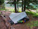
My Tarptent Squall |
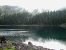
Lost Lake |
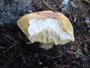
Mushroom Meal |
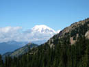
Mt. Rainier |
Old Snowy |
Tieton Peak |
Photo Page 2
Trips - 2004
Home