6-12-04
This is one of my favorite hikes
and I was surprised to see that it had been almost 9 years since I had
last done it. The day before I had a short cold snow climb to the summit
of Fortune Peak. This day I determined to head as far east as I could in
the Teanaway and hope for warmer weather. I camped in the valley and it
was nice to sleep in, have an unhurried breakfast and still be at the trailhead
by 8:30. I was the only car in the lot at the end of the Stafford Creek
Road. There were a few clouds in the sky and it was chilly but it promised
to be a very nice day. This loop would be clockwise so I started out on
the trail to Miller Peak. In the first half mile I saw remnants of trillium
and columbine. I was a few weeks late to enjoy them. There were also some
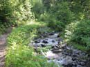
indian paintbrush and other flowers as well. This trail crosses the creek
again and again. All of the crossings were about as high and wide as they
ever get. Poles were crucial to getting across several with dry feet. None
were at all deep so the worst case would be a wet foot or two. After 45
minutes I figured I had traveled about 2 miles and had gained only 750'.
At that point the route began to climb. The next 2 1/2 miles gained 2500'
more.
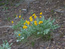
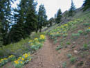
This is a motorcycle raceway and can be noisy and smelly in mid summer. A few spots hold snow late and can stop the wheels cold. I hoped there would not be much snow but enough to stop the cycles. I was half right. With an early start I expected to make it up Miller before they would arrive anyway. Some of the switchback corners were torn up by wheels but overall the trail was in great shape. The gain is considerable in the second half of the way to Miller but it is very smoothly graded. When I hit the first ridge top I had a nice view of Iron Bear Peak where I would be later in the afternoon. As the forest thinned the views began and so did the flowers. The balsamroot were right at their peak. The high rock garden was spectacular. It continued for most of the day.
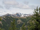
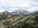
The top of Mt. Stuart was in the clouds where it was destined to spend the day. Most everything else was clear. I had a great view of the snowfield on Fortune Peak I had climbed up the day before. Jolly Mountain was to the west. Even most of Mt. Rainier was out. Earl, Little Navaho, Navaho, and Three Brothers were the close peaks that dominated the view. Last year I was on top of Jolly, Earl, Navaho, and Three Brothers. One section of trail in forest had the only snow of the day. It was about 30 feet long and will be gone very soon. It was no problem at all to cross. After passing through a hillside loaded with blooming balsamroot the trail again attained the ridge top. Now I was looking across at Iron Bear and not up at it. More traversing and I came to the final ridge crest just below the summit of Miller. A short steep section of trail and I was on top of Miller. It was just about 11:00 as I took 2:20 to reach the top. A part of that was stopping to take pictures of all the flowers.
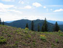
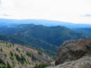
From the top I could see all of my route around to Iron Bear and down Bear Creek to close the loop. As I neared the summit rocks a lone bird, which I think was a ptarmigan, was enjoying the view. I snapped her picture as she did not seem ready to leave yet. I nearly reached her before she deigned to move a short way down to make room for me. After a quick lunch and more photos I was ready to head down. Now that the work of gaining 3200' was out of the way the real fun began. Instead of retracing my steps all the way back to the County Line Trail I headed straight down the east ridge. In less than 10 minutes I was down on the mostly level ridge. The north slope of the ridge was snow covered but the south slope and crest were bare. There is one short scramble spot on the ridge but otherwise it is a beautiful ridge walk. All too soon the descending ridge and ascending County Line Trail came close together. I dropped down the open slopes and attained the trail. At that point the trail touches the ridge and there were half a dozen motorcyclists there. They turned out to be real nice guys and we talked a little. I soon headed on my way.
The trail works it's way down to a pass where the gated road up Shaser Creek meets the ridge. This pass is the place Gary and I accidentally reached on mountain bikes several years ago. That trip turned out to be a real adventure. The slopes along here are mostly open with many flowers, highlighted by acres of balsamroot. I suddenly heard a noise coming up behind me and jumped off the trail. It turned out to be the motorcyclists coasting down the hill. After passing me and descending farther they started up there motors and took off. I'd like to think they coasted by as a courtesy to me to avoid the noise and smell. Didn't I say they were nice guys. Regardless of the motive it was appreciated. When the ridge turned and began pointing towards Iron Bear the rock garden got even better. At one point a tall rock wall was blasted out and the trail goes right through it. A few more ups and downs and I dropped down to the pass. There was another group of cycles here and a lone hiker. He was only the second hiker I had seen all day, both in the same area.
The next section is not my favorite. The route climbs straight up on loose gravel. I mean straight up. This is fine for motorcycles but it's steep and loose for boots. I checked the gain and it turned out to be 250' in a very short distance. The good news is that is half the gain to the top of Iron Bear. Before returning to forest I had a great view of my route all the way back to Miller Peak. The trail climbs to almost the top of a peak then drops a little and climbs to the top of Iron Bear. I was up there last October in a rain/snow storm enjoying the golden larch along the trail. Now they are freshly clad in their light green needles. I passed the turn off where the Teanaway Ridge Trail heads towards the old Blewett Pass. I kept right and in just a few minutes I was on the summit of Iron Bear. Nearly my whole route was clearly seen from this vantage point. It took about 1:45 from Miller and it was now 1:10. I sat down to the second half of my lunch. Iron Bear is easily accessed via the Iron Creek trail and I seldom have the summit to myself. This day I was alone. From here the way was all downhill.
Just below the summit I passed the third and last group of hikers I was to see. The trail down to Iron Bear Pass was filled with flowers. Some were past their peak but a surprising number were still in full bloom. This slope melts out early and I expected the flowers to be about finished. It was a nice surprise to see such colors. Balsamroot and multiple colors or paintbrush were the best. I saw more lupine here than elsewhere along the route as well. When I reached the pass I did a little exploring and found a big patch of bitterroot in full bloom. They were probably the flower highlight of the day.
The trail down Bear Creek is really lonesome walking. I didn't expect to see any hikers and I was not disappointed. The trail quickly dropped down then leveled off. The last three miles seemed to last forever. The creek is at first small and can be easily stepped over. It grows bigger with every crossing and there are many of them. Only a few recently placed logs allowed me to get across with dry feet at several spots. Each time I thought I was at the end the trail went around another bend and another long straight away was ahead. At long, long, long last I reached the final creek crossing and popped out into the parking lot 100' from the Miller trail I had started on exactly 7 hours earlier. For the day I hiked 13 miles gaining 3900' seeing few people and many flowers and mountains. I won't wait another 9 years to come back again.
Click on thumbnails to get larger pictures.
Photo Page 2
Trips - 2004
Home
This is a motorcycle raceway and can be noisy and smelly in mid summer. A few spots hold snow late and can stop the wheels cold. I hoped there would not be much snow but enough to stop the cycles. I was half right. With an early start I expected to make it up Miller before they would arrive anyway. Some of the switchback corners were torn up by wheels but overall the trail was in great shape. The gain is considerable in the second half of the way to Miller but it is very smoothly graded. When I hit the first ridge top I had a nice view of Iron Bear Peak where I would be later in the afternoon. As the forest thinned the views began and so did the flowers. The balsamroot were right at their peak. The high rock garden was spectacular. It continued for most of the day.
The top of Mt. Stuart was in the clouds where it was destined to spend the day. Most everything else was clear. I had a great view of the snowfield on Fortune Peak I had climbed up the day before. Jolly Mountain was to the west. Even most of Mt. Rainier was out. Earl, Little Navaho, Navaho, and Three Brothers were the close peaks that dominated the view. Last year I was on top of Jolly, Earl, Navaho, and Three Brothers. One section of trail in forest had the only snow of the day. It was about 30 feet long and will be gone very soon. It was no problem at all to cross. After passing through a hillside loaded with blooming balsamroot the trail again attained the ridge top. Now I was looking across at Iron Bear and not up at it. More traversing and I came to the final ridge crest just below the summit of Miller. A short steep section of trail and I was on top of Miller. It was just about 11:00 as I took 2:20 to reach the top. A part of that was stopping to take pictures of all the flowers.
From the top I could see all of my route around to Iron Bear and down Bear Creek to close the loop. As I neared the summit rocks a lone bird, which I think was a ptarmigan, was enjoying the view. I snapped her picture as she did not seem ready to leave yet. I nearly reached her before she deigned to move a short way down to make room for me. After a quick lunch and more photos I was ready to head down. Now that the work of gaining 3200' was out of the way the real fun began. Instead of retracing my steps all the way back to the County Line Trail I headed straight down the east ridge. In less than 10 minutes I was down on the mostly level ridge. The north slope of the ridge was snow covered but the south slope and crest were bare. There is one short scramble spot on the ridge but otherwise it is a beautiful ridge walk. All too soon the descending ridge and ascending County Line Trail came close together. I dropped down the open slopes and attained the trail. At that point the trail touches the ridge and there were half a dozen motorcyclists there. They turned out to be real nice guys and we talked a little. I soon headed on my way.
The trail works it's way down to a pass where the gated road up Shaser Creek meets the ridge. This pass is the place Gary and I accidentally reached on mountain bikes several years ago. That trip turned out to be a real adventure. The slopes along here are mostly open with many flowers, highlighted by acres of balsamroot. I suddenly heard a noise coming up behind me and jumped off the trail. It turned out to be the motorcyclists coasting down the hill. After passing me and descending farther they started up there motors and took off. I'd like to think they coasted by as a courtesy to me to avoid the noise and smell. Didn't I say they were nice guys. Regardless of the motive it was appreciated. When the ridge turned and began pointing towards Iron Bear the rock garden got even better. At one point a tall rock wall was blasted out and the trail goes right through it. A few more ups and downs and I dropped down to the pass. There was another group of cycles here and a lone hiker. He was only the second hiker I had seen all day, both in the same area.
The next section is not my favorite. The route climbs straight up on loose gravel. I mean straight up. This is fine for motorcycles but it's steep and loose for boots. I checked the gain and it turned out to be 250' in a very short distance. The good news is that is half the gain to the top of Iron Bear. Before returning to forest I had a great view of my route all the way back to Miller Peak. The trail climbs to almost the top of a peak then drops a little and climbs to the top of Iron Bear. I was up there last October in a rain/snow storm enjoying the golden larch along the trail. Now they are freshly clad in their light green needles. I passed the turn off where the Teanaway Ridge Trail heads towards the old Blewett Pass. I kept right and in just a few minutes I was on the summit of Iron Bear. Nearly my whole route was clearly seen from this vantage point. It took about 1:45 from Miller and it was now 1:10. I sat down to the second half of my lunch. Iron Bear is easily accessed via the Iron Creek trail and I seldom have the summit to myself. This day I was alone. From here the way was all downhill.
Just below the summit I passed the third and last group of hikers I was to see. The trail down to Iron Bear Pass was filled with flowers. Some were past their peak but a surprising number were still in full bloom. This slope melts out early and I expected the flowers to be about finished. It was a nice surprise to see such colors. Balsamroot and multiple colors or paintbrush were the best. I saw more lupine here than elsewhere along the route as well. When I reached the pass I did a little exploring and found a big patch of bitterroot in full bloom. They were probably the flower highlight of the day.
The trail down Bear Creek is really lonesome walking. I didn't expect to see any hikers and I was not disappointed. The trail quickly dropped down then leveled off. The last three miles seemed to last forever. The creek is at first small and can be easily stepped over. It grows bigger with every crossing and there are many of them. Only a few recently placed logs allowed me to get across with dry feet at several spots. Each time I thought I was at the end the trail went around another bend and another long straight away was ahead. At long, long, long last I reached the final creek crossing and popped out into the parking lot 100' from the Miller trail I had started on exactly 7 hours earlier. For the day I hiked 13 miles gaining 3900' seeing few people and many flowers and mountains. I won't wait another 9 years to come back again.
Miller Creek |

First Views |
Earl Peak |
Balsamroot |

Miller Ridge |
Iron Bear Peak |
Balsamroot |

Navaho Peak |
Navaho Close Up |
Iron Bear Peak |
Photo Page 2
Trips - 2004
Home