5-15-04
Last fall I hiked part of the
new Mason Lake trail while going up Bandera Mountain. Part of it was still
closed off. I decided to scramble up Mt. Defiance and check out the whole
trail as well. The forecast was for afternoon rain and possible thunder showers.
I did not want to get caught up on a summit with lightning while carrying
an ice axe so I headed out early. There were already 4 cars in the lot when
I got started at 7:55 am. I passed a couple at the waterfall along the
trail. The old Mason Lake trail(s) turn off is still obvious and not blocked
but unsigned. There is a temporary sign here warning of possible detours
while construction is on going. The trail looked to be finished to me.
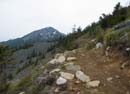
Now a few comments on the new trail. This should be a template for future
construction. This trail is well built but not over built. There is no
unnecessary gravel. There are only a few waterbars. There are no steps.
It does not resemble a narrow gauge road. It is an honest to goodness dirt
trail. Yippee!! The grade is moderate but not just a 5 - 10% grade. A few
spots are a little steeper. The trail is plenty wide enough for two people
to pass but is not overly wide. A year's rain, snow, and spring melt have
done no damage to the trail. This is by far the least "road like" trail that
has been built in a long time. I hope to see more just like it.
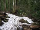
I had hoped to see some of the multitudes of flowers that grow along the upper open slopes of Bandera. Although the snow has been gone for some weeks the flower show has not yet begun. I did see trillium and bleeding heart in the lower forest. A few lupine are also blooming. The real show is still a few weeks away. Where the trail breaks out into the open I passed two folks on there way up for some fishing at the lake. They were the last people I saw until I make it back down to Mason Lake coming out. The trail was completely snow free until the final drop down to Mason Lake. The section to the lake was partly bare and partly snow covered. It was very easy to follow the trail. The intersection with the old trail is not marked but is still quite obvious. There are signs here pointing to the "Bandera Mountain Trail". I was surprised to see that the lake itself is 95% melted out. There is very little snow on the trail side of the lake. I saw no signs of any campers.
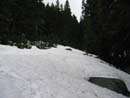
As I left the lake the snow began again. I had no trouble finding the intersection of the Defiance trail. The intersection itself was snow free. I put on gaiters here and took a left turn towards Mt. Defiance. There were a few footprints in the snow and I chose to follow them as far as I could. The trail was soon completely under a thin covering of snow. As I gained elevation the snow cover deepened. The trail begins on the ridge top but soon drops to the north side of the ridge. With little sunshine here the snow is still up to 3+ feet deep. At one point the prints diverged and I chose to follow the ones heading straight up the ridge rather than those paralleling it. The route quickly became much steeper and I pulled out my ice axe. It would have been easy with more snow but it was too thin in places to kick any steps. This was definitely not the easy way. When the going got a little nasty I magically came upon footprints again. A little traverse and I was on top of the ridge. The ridge top had some bare spots and low and behold I was back on the summer trail.
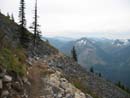
I stayed on or near the ridge until the footprints began to contour around to the south side of the mountain. I considered staying on the ridge all the way up. I have done it once on snowshoes with much more snow. The snow was a little soft and crummy so I decided to continue around to the bare slopes of the south side and follow the summer trail all the way up. The snow traverse went on much longer than I expected. Alone and without an ice axe I might have turned around. With the axe I felt comfortable kicking steps in the somewhat soft snow. I finally came off of the snow right on the summer trail. There were 3 or 4 more short snow fields to cross but they were no problem. As with Bandera the flowers have not yet made much of an appearance. Glacier lilies were along the south face but not much else. The clouds had really come in. On Bandera there were high overhead clouds. Now the clouds blotted out I-90 and the other side of the valley. The dark misty conditions were actually kind of neat.
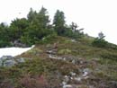
I reached the bare intersection with the summit trail and headed up. I expected this southwest facing route to be snow free. The lower part was but not higher up. The footprint maker chose to stay directly on the rib where the trail began to contour to the right (east). I followed the real trail up but took the snow covered rib down. The thin snow on the real trail was much more tedious. The summit rocks are bare but there is still plenty of snow on the north side from the summit on down. Views were nonexistent.
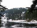
It took me 1:28 to cover the 4 or so miles to Mason Lake. It took another 1:35 to go the last 2 or less miles to the summit. All totaled it took just about 3 hours. It was just 11:00 and the weather was dark but still dry. With no views I only spent about 15 minutes on top while having lunch. The way down was easier. I had my own fresher footprints to follow. I avoided that one steep spot by contouring farther left as I dropped. I managed to see a little of Lake Kulla Kulla through the trees. It is not frozen. I did get off track and dropped too far towards the lake before noticing my mistake. Hopefully nobody else will follow my wrong route. From Mason Lake there is one final short climb then it's all downhill at a very pleasant grade. The early afternoon brought out a few more groups but not as many as I expected. In a case of near perfect timing I reached my car just as the first rain drops began to fall. The old trail is a much shorter way to get up Mt. Defiance but the new trail is much more enjoyable and easier on the legs. Overall, it was a great day to be in the mountains.
Click on thumbnails to get larger pictures.
Photo Page 2
Trips - 2004
Home
I had hoped to see some of the multitudes of flowers that grow along the upper open slopes of Bandera. Although the snow has been gone for some weeks the flower show has not yet begun. I did see trillium and bleeding heart in the lower forest. A few lupine are also blooming. The real show is still a few weeks away. Where the trail breaks out into the open I passed two folks on there way up for some fishing at the lake. They were the last people I saw until I make it back down to Mason Lake coming out. The trail was completely snow free until the final drop down to Mason Lake. The section to the lake was partly bare and partly snow covered. It was very easy to follow the trail. The intersection with the old trail is not marked but is still quite obvious. There are signs here pointing to the "Bandera Mountain Trail". I was surprised to see that the lake itself is 95% melted out. There is very little snow on the trail side of the lake. I saw no signs of any campers.
As I left the lake the snow began again. I had no trouble finding the intersection of the Defiance trail. The intersection itself was snow free. I put on gaiters here and took a left turn towards Mt. Defiance. There were a few footprints in the snow and I chose to follow them as far as I could. The trail was soon completely under a thin covering of snow. As I gained elevation the snow cover deepened. The trail begins on the ridge top but soon drops to the north side of the ridge. With little sunshine here the snow is still up to 3+ feet deep. At one point the prints diverged and I chose to follow the ones heading straight up the ridge rather than those paralleling it. The route quickly became much steeper and I pulled out my ice axe. It would have been easy with more snow but it was too thin in places to kick any steps. This was definitely not the easy way. When the going got a little nasty I magically came upon footprints again. A little traverse and I was on top of the ridge. The ridge top had some bare spots and low and behold I was back on the summer trail.
I stayed on or near the ridge until the footprints began to contour around to the south side of the mountain. I considered staying on the ridge all the way up. I have done it once on snowshoes with much more snow. The snow was a little soft and crummy so I decided to continue around to the bare slopes of the south side and follow the summer trail all the way up. The snow traverse went on much longer than I expected. Alone and without an ice axe I might have turned around. With the axe I felt comfortable kicking steps in the somewhat soft snow. I finally came off of the snow right on the summer trail. There were 3 or 4 more short snow fields to cross but they were no problem. As with Bandera the flowers have not yet made much of an appearance. Glacier lilies were along the south face but not much else. The clouds had really come in. On Bandera there were high overhead clouds. Now the clouds blotted out I-90 and the other side of the valley. The dark misty conditions were actually kind of neat.
I reached the bare intersection with the summit trail and headed up. I expected this southwest facing route to be snow free. The lower part was but not higher up. The footprint maker chose to stay directly on the rib where the trail began to contour to the right (east). I followed the real trail up but took the snow covered rib down. The thin snow on the real trail was much more tedious. The summit rocks are bare but there is still plenty of snow on the north side from the summit on down. Views were nonexistent.
It took me 1:28 to cover the 4 or so miles to Mason Lake. It took another 1:35 to go the last 2 or less miles to the summit. All totaled it took just about 3 hours. It was just 11:00 and the weather was dark but still dry. With no views I only spent about 15 minutes on top while having lunch. The way down was easier. I had my own fresher footprints to follow. I avoided that one steep spot by contouring farther left as I dropped. I managed to see a little of Lake Kulla Kulla through the trees. It is not frozen. I did get off track and dropped too far towards the lake before noticing my mistake. Hopefully nobody else will follow my wrong route. From Mason Lake there is one final short climb then it's all downhill at a very pleasant grade. The early afternoon brought out a few more groups but not as many as I expected. In a case of near perfect timing I reached my car just as the first rain drops began to fall. The old trail is a much shorter way to get up Mt. Defiance but the new trail is much more enjoyable and easier on the legs. Overall, it was a great day to be in the mountains.
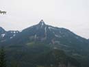
McClellan Butte |
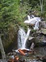
Waterfall |
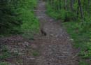
Rabbit |
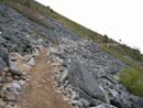
Blasted Trail |
Mt. Defiance |
Southeast View |
Snow Near Lake |
Mason Lake |
Deeper Snow |
Summit Trail |
Photo Page 2
Trips - 2004
Home