5-30-04
After several weeks of forced idleness
for both Gary and I, we planned a hike for the middle of the Memorial Day
weekend. The forecast was for a typically lousy holiday weekend so we decided
to head east. The snow level was only at 5500' and a west wind was supposed
to gust to 30 mph. Still the rain chance was much lower than at the crest
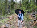
or to the west. We met in Issaquah at 7:00 am and were ready to hit the Stafford
Creek trail at 9:00. There were already about 4 cars in the lot and one woman
who left just before us. There was a little off and on drizzle but no real
rain yet. We saw some flowers early on. A few paintbrush were blooming and
a few trillium were about done. The valley protects the lower trail from
westerly winds and we had almost none. Stafford Creek is really raging now
and the side creeks are high but none were too difficult to cross. After
1 1/2 miles or so we met and passed Shayna who was taking a break.
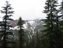
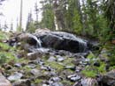
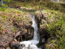
The clouds were too low to even see the top of the valley walls. The rain picked up a little but with umbrellas it was no problem. The biggest creek of the day is the one after the switchbacks which comes right down off of Navaho Peak. It required some rock hopping but we crossed with dry feet. The next section in thin forest still had some snow. None of it was on the trail. It had not been gone long as there was a profusion of glacier lilies along this stretch. This is known as a dry dusty trail and it is in the summer. Right now it is lush and very wet. As we neared the Standup Creek trail intersection the trail became rocky and a creek in spots. A little brief trail maintenance dried up several sections. The next part has several very long switchbacks which do not gain much elevation. There were a couple nice waterfalls along here. While stopped to take a photo of one falls, Shayna passed us again. She was only planning on going as far as the pass.
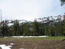
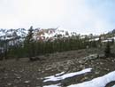
We reached the meadow to find it mostly wet and green with some snow around the edges. The campsite looked to be clear. The trail is not real obvious where it crosses the meadow but we saw that Shayna had found the trail on the other side. There was some snow from here to the pass but most of it could be avoided. We reached the pass to find it was clear. There was still quite a lot of snow on the north side of the pass. The clouds covered most of the Stuart Range just across the valley of Ingalls Creek. After a brief stop we were onto the County Line trail heading up Navaho. From the pass the summit was visible through the clouds. I had mentioned to Shayna that if the clouds lifted a little there were much better views above and to the east of the pass. She had already headed up when we arrived. The first part is on a southern exposure and was bare dirt. As the route swung onto the crest and to the north of the ridge we were on snow. A number of others have been up recently and their footprints were obvious.
Once on solid snow Gary and I stopped to put on more clothing, gaiters, and get out our ice axes. The route is not very steep and the snow was soft enough to kick solid steps. An axe was nice but not necessary. We once again caught up with Shayna and offered her guide services to the summit. It turned out she is from Portland and had not been in the Teanaway area before. She took us up on our offer and we continued up the ridge. The rest of the way was split between dirt and snow. The snow parts actually gave me better footing. The wind had perked up periodically but overall had not been bad. In short order we finished the 1200' gain from the pass and topped out on the summit of Navaho. Small trees near the top were coated in solid ice. The wind began to pick up. My thermometer had read 40 at the pass and now it read 35 degrees. We were able to drop down on the east side of the summit and escape the wind. It may have been one day short of June but at 7223 feet it was winter. Soon big fluffy snow flakes began to fall. Views were virtually nonexistent.
We managed to get down some lunch and off to the east Three Brothers came into view. McClellan Peak popped out of the clouds and a moment later was gone again. I took a look for the summit register and found that it is gone. I saw it last May but it has since disappeared. Shayna managed to hold still on the summit in very strong wind and I took a summit photo with the lower half of Mt. Stuart visible. Of couse, unless you knew what it was there was no way to know it was Stuart. We probably managed to hold out on top for nearly half an hour. When my hands began to shake it was time to get moving and try to warm up. I don't think I had a winter trip that was as cold as the top of Navaho Peak at the end of May.
The trip down to the pass was quite quick. By staying to the left of the ridge we were on snow much of the way. Some plunge stepping and standing glissades were much easier on the knees than the bare dirt would have been. Once back at the pass we put away the axes and headed on down the trail. We were in no great hurry coming down and stopped to take many photos. The drizzle came and went but never turned into hard rain. At long last we reached the trailhead at about 4:15. It was much colder and wetter than last year's spring scramble of Navaho. There were few views this year and spectacular ones last year. Still, this felt like a spring trip lower down and a real winter climb at the top. All in all it was a great day to be on the trail.
Click on thumbnails to get larger pictures.
Photo Page 2
Trips - 2004
Home
The clouds were too low to even see the top of the valley walls. The rain picked up a little but with umbrellas it was no problem. The biggest creek of the day is the one after the switchbacks which comes right down off of Navaho Peak. It required some rock hopping but we crossed with dry feet. The next section in thin forest still had some snow. None of it was on the trail. It had not been gone long as there was a profusion of glacier lilies along this stretch. This is known as a dry dusty trail and it is in the summer. Right now it is lush and very wet. As we neared the Standup Creek trail intersection the trail became rocky and a creek in spots. A little brief trail maintenance dried up several sections. The next part has several very long switchbacks which do not gain much elevation. There were a couple nice waterfalls along here. While stopped to take a photo of one falls, Shayna passed us again. She was only planning on going as far as the pass.
We reached the meadow to find it mostly wet and green with some snow around the edges. The campsite looked to be clear. The trail is not real obvious where it crosses the meadow but we saw that Shayna had found the trail on the other side. There was some snow from here to the pass but most of it could be avoided. We reached the pass to find it was clear. There was still quite a lot of snow on the north side of the pass. The clouds covered most of the Stuart Range just across the valley of Ingalls Creek. After a brief stop we were onto the County Line trail heading up Navaho. From the pass the summit was visible through the clouds. I had mentioned to Shayna that if the clouds lifted a little there were much better views above and to the east of the pass. She had already headed up when we arrived. The first part is on a southern exposure and was bare dirt. As the route swung onto the crest and to the north of the ridge we were on snow. A number of others have been up recently and their footprints were obvious.
Once on solid snow Gary and I stopped to put on more clothing, gaiters, and get out our ice axes. The route is not very steep and the snow was soft enough to kick solid steps. An axe was nice but not necessary. We once again caught up with Shayna and offered her guide services to the summit. It turned out she is from Portland and had not been in the Teanaway area before. She took us up on our offer and we continued up the ridge. The rest of the way was split between dirt and snow. The snow parts actually gave me better footing. The wind had perked up periodically but overall had not been bad. In short order we finished the 1200' gain from the pass and topped out on the summit of Navaho. Small trees near the top were coated in solid ice. The wind began to pick up. My thermometer had read 40 at the pass and now it read 35 degrees. We were able to drop down on the east side of the summit and escape the wind. It may have been one day short of June but at 7223 feet it was winter. Soon big fluffy snow flakes began to fall. Views were virtually nonexistent.
We managed to get down some lunch and off to the east Three Brothers came into view. McClellan Peak popped out of the clouds and a moment later was gone again. I took a look for the summit register and found that it is gone. I saw it last May but it has since disappeared. Shayna managed to hold still on the summit in very strong wind and I took a summit photo with the lower half of Mt. Stuart visible. Of couse, unless you knew what it was there was no way to know it was Stuart. We probably managed to hold out on top for nearly half an hour. When my hands began to shake it was time to get moving and try to warm up. I don't think I had a winter trip that was as cold as the top of Navaho Peak at the end of May.
The trip down to the pass was quite quick. By staying to the left of the ridge we were on snow much of the way. Some plunge stepping and standing glissades were much easier on the knees than the bare dirt would have been. Once back at the pass we put away the axes and headed on down the trail. We were in no great hurry coming down and stopped to take many photos. The drizzle came and went but never turned into hard rain. At long last we reached the trailhead at about 4:15. It was much colder and wetter than last year's spring scramble of Navaho. There were few views this year and spectacular ones last year. Still, this felt like a spring trip lower down and a real winter climb at the top. All in all it was a great day to be on the trail.
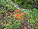
Indian Paintbrush |
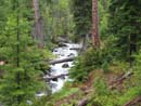
Stafford Creek |
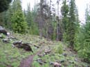
Wet Trail |
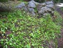
Glacier Lilies |
Gary |
Low Clouds |
Waterfall |
Meadow |
Waterfall |
Nearing The Pass |
Photo Page 2
Trips - 2004
Home