4-03-04
This is one of my favorite close
in early spring hikes. The lower section is snow free and the upper section
is easy to navigate. With snowshoes it's no problem reaching the ridge top.
There are nice views of mountains and snow covered lakes from the ridge.
The vast majority of hikers head up Granite Mountain and it's quiet after
the first mile. This day was forecast to be warm and sunny. I had a fairly
early start and was on the trail by 8:30. At about 1/2 mile there was a nice
patch of trillium and a few violets. Unfortunately that was the end of the
flowers. This is not a great flower hike but it will be better in a few weeks.
Just before the one mile marker is the turn off to Granite Mountain. I turned
left and immediately saw a hiker and a tent. I have never seen a tent this
close to the start so I stopped to talk. The hiker had come in late Friday
evening and made it this far. He planned to head on to Pratt Lake. After a
short conversation I was moving again.
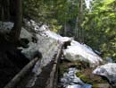
The toughest part of this trip in spring is usually the big creek crossing at about 1 1/4 miles. It is often small in the morning and a raging torrent with the afternoon snow melt. There are now so many rocks across the creek that it was an easy crossing. The way continued west, paralleling the highway. It remained snow free until turning north. Here snow began quickly. Within 75' the trail went from bare to buried under 6-8" of snow. It quickly deepened. I would guess that the snow started at about 2 1/2 miles. The hardest part now was the narrow wooden bridges. The snow melts faster at the top making a triangle. It is very narrow at the top. The snow was plenty hard enough not to post hole which made it impossible to stomp a wide path across these bridges. On either side of the bridge the snow over the creek melts faster making a step there a little risky. In some places one could fall 6-10 feet to the water below. I carefully worked my way around many of these. Those who are unaware tromp merrily over very weak snow bridges without realizing the danger. With a good deal of care I passed by all the bridges.
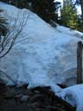
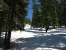
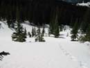
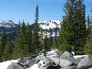
At three miles I noticed the sign for the route to Talapus and Olallie Lakes. The footprints continuing on lessened but there were still a few. The next hurdle is the crossing of the Olallie Lake inlet creek. In the summer it is a level step across of a tiny creek. In the spring it can be a little more interesting. The last time I was here in the spring I gingerly crossed a snow bridge 10 feet above the creek. This time the creek was uncovered. I kicked steps down about 8 feet to the creek, crossed on rocks, and kicked steps back up the other side. The real fun part of the trip began here. I put on snowshoes and headed into a mass of small trees. The trick is to get through this zone without post holing to your neck or falling into a tree well up to your neck. I weaved in and around, never going in a straight line. In general, I aimed a little to the left. After successfully navigating this tough section the route entered more open forest. The forest provided enough shade ot keep the snow hard. When I left the forest the grade steepened rapidly. Here the sun shone brightly and the snow softened. I sank about 6-10 inches with every step. Fortunately, I did not post hole to my crotch. The going slowed down but was still not bad.
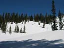
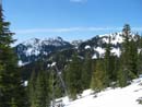
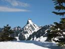
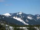
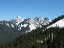
The last push to the ridge was steep but not too tough. As I climbed Mt. Rainier came into view. Bandera and Pratt Mt. also rose above the trees. I aim for the far right end of the ridge where it goes from fairly flat to a steep slope up Granite Mountain. I crested the top at about 11:00. Kaleetan Peak dominated the view to the north. Chair Peak is right along side. Looking back to the west I recognized Revolution Peak and Point 5124, where I was in early January. Just below the ridge to the north is a small frozen lake . The wind was light until I reached the top where it began to blast away. I sat down behind some rocks and put on two more layers of clothing and gloves. From there the wind was not too bad. When I started out in the morning another hiker asked about any other routes up Granite. I mentioned that my route could be continued up the ridge to the summit. After half an hour on the ridge a heard the sound of foot steps. There he was. He had followed my route but did not have snowshoes. The last slope had been a long series of post holing for him. I had lunch and watched as he continued on up Granite. I hope the snow was firmer for him higher up.
After more than an hour on top I reluctantly headed down. The snow was far too soft to allow glissading so I kept on the snowshoes and plunged on down. A short way below the ridge I had a nice view of frozen and snow covered Olallie Lake. The route back was easy walking. When I reached the real trail I saw a pair of snowshoe tracks. The backpacker was well on his way to Pratt Lake. When I reached the end of the snow my solitude lessened. I passed 4 or 5 groups heading up. Several of them had no idea what was ahead. I'm amazed that people head out for a hike with no idea what's up the trail let along carry a map or a compass. The big creek crossing proved to be no problem even with the rapid snow melt above. By 2:10 I was back at the car. This trip proved once again to be a fun snow hike with some very nice views. I'm sure I'll be back in a year or two.
Click on thumbnails to get larger pictures.
Photo Page 2
Trips 2004
Home
The toughest part of this trip in spring is usually the big creek crossing at about 1 1/4 miles. It is often small in the morning and a raging torrent with the afternoon snow melt. There are now so many rocks across the creek that it was an easy crossing. The way continued west, paralleling the highway. It remained snow free until turning north. Here snow began quickly. Within 75' the trail went from bare to buried under 6-8" of snow. It quickly deepened. I would guess that the snow started at about 2 1/2 miles. The hardest part now was the narrow wooden bridges. The snow melts faster at the top making a triangle. It is very narrow at the top. The snow was plenty hard enough not to post hole which made it impossible to stomp a wide path across these bridges. On either side of the bridge the snow over the creek melts faster making a step there a little risky. In some places one could fall 6-10 feet to the water below. I carefully worked my way around many of these. Those who are unaware tromp merrily over very weak snow bridges without realizing the danger. With a good deal of care I passed by all the bridges.
At three miles I noticed the sign for the route to Talapus and Olallie Lakes. The footprints continuing on lessened but there were still a few. The next hurdle is the crossing of the Olallie Lake inlet creek. In the summer it is a level step across of a tiny creek. In the spring it can be a little more interesting. The last time I was here in the spring I gingerly crossed a snow bridge 10 feet above the creek. This time the creek was uncovered. I kicked steps down about 8 feet to the creek, crossed on rocks, and kicked steps back up the other side. The real fun part of the trip began here. I put on snowshoes and headed into a mass of small trees. The trick is to get through this zone without post holing to your neck or falling into a tree well up to your neck. I weaved in and around, never going in a straight line. In general, I aimed a little to the left. After successfully navigating this tough section the route entered more open forest. The forest provided enough shade ot keep the snow hard. When I left the forest the grade steepened rapidly. Here the sun shone brightly and the snow softened. I sank about 6-10 inches with every step. Fortunately, I did not post hole to my crotch. The going slowed down but was still not bad.
The last push to the ridge was steep but not too tough. As I climbed Mt. Rainier came into view. Bandera and Pratt Mt. also rose above the trees. I aim for the far right end of the ridge where it goes from fairly flat to a steep slope up Granite Mountain. I crested the top at about 11:00. Kaleetan Peak dominated the view to the north. Chair Peak is right along side. Looking back to the west I recognized Revolution Peak and Point 5124, where I was in early January. Just below the ridge to the north is a small frozen lake . The wind was light until I reached the top where it began to blast away. I sat down behind some rocks and put on two more layers of clothing and gloves. From there the wind was not too bad. When I started out in the morning another hiker asked about any other routes up Granite. I mentioned that my route could be continued up the ridge to the summit. After half an hour on the ridge a heard the sound of foot steps. There he was. He had followed my route but did not have snowshoes. The last slope had been a long series of post holing for him. I had lunch and watched as he continued on up Granite. I hope the snow was firmer for him higher up.
After more than an hour on top I reluctantly headed down. The snow was far too soft to allow glissading so I kept on the snowshoes and plunged on down. A short way below the ridge I had a nice view of frozen and snow covered Olallie Lake. The route back was easy walking. When I reached the real trail I saw a pair of snowshoe tracks. The backpacker was well on his way to Pratt Lake. When I reached the end of the snow my solitude lessened. I passed 4 or 5 groups heading up. Several of them had no idea what was ahead. I'm amazed that people head out for a hike with no idea what's up the trail let along carry a map or a compass. The big creek crossing proved to be no problem even with the rapid snow melt above. By 2:10 I was back at the car. This trip proved once again to be a fun snow hike with some very nice views. I'm sure I'll be back in a year or two.
Snowy Bridge |
Creek Crossing |
Leaving Forest |
Ridge In Sight |
Half Way Up |
Bandera & Pratt Mts |
Kaleetan Peak |
Point 5124 |
Kaleetan & Pratt Mts |
Pratt Mountain |
Photo Page 2
Trips 2004
Home