6-27-04
I have hiked the Domerie Divide
Trail a number of times with multiple summits of both Domerie and Baldy.
I had only hiked to the top of Thomas Mountain one time and it was all on
snow. That
trip
was one of the coldest I have ever been on. It was 15 degrees with high
winds blowing ice pellets horizontally at us. This time I wanted to see
the whole trail on a warm sunny day. I made it out of Seattle at a reasonably
early 6:45. It took just about 1 1/2 hours to the trailhead and I was on
the trail at 8:20. This is a very steep trail on a southwest slope. A late
start can make for a horribly hot ascent. Mine was the only car in the lot.
There was a group camping at the old trailhead along Silver Creek. They
were the only people I saw all day long. The fairly new bridge ends the
old game of trying to find a way across with dry boots. The trail was signed
"hikers only" but I saw fresh horse droppings and lots of tire tracks. There
is now a metal barricade made of vertical pipes at the bridge which may
keep some non hikers away. Any thoughts about this being a 10% graded trail
end in the first 100 feet. At least there are steep switchbacks here. Later
it just becomes a trail straight up the slope. After just a few quick switchbacks,
gaining 300', the route intersects an old logging road. A left turn quickly
leads to a sharp right turn in the road. The trail picks up again across
the road.
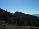
The first section above the road is in an old clear cut. It's a little overgrown but not enough to hinder a hiker. The flower show began here with many tiger lilies. Most were still at their peak. I also saw a few huckleberries. They were not ripe but were already full sized. It was pleasant hiking here as the sun was not yet on the exposed hillside. This trail up to the ridge top is nicely graded. It's much less steep than what awaits above. After a number of switchbacks I reached the ridge and a trail intersection. The Rosalyn watershed is in the valley below. The trail going right follows the ridge along one side of the valley. My trail follows along the other side. There are signs warning not to enter the watershed posted all along the ridge. There were already nice views out to Lake Kachess, Lake Easton, and Amabilis Mountain. The views would only improve as I moved higher. It took me 45 minutes gaining 1100' to the trail intersection. The trail follows the nearly flat ridge for awhile before the real fun begins.
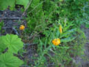
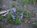
When the trail begins to climb there is no doubt about it. I planned to use poles for this section. I put them with my hiking gear the night before. In the morning I set them on the front porch as I was loading the car. That's exactly where they spent the rest of the day. They would have been very useful both up and downhill. The last time I saw this slope it was under several feet of slow. I think it was easier in snowshoes, even slogging through soft snow. I know it was easier coming down in the snow. The trail is very dusty as tires have turned it to a sandy consistency. On the positive side, this trail does provide a great workout. As I climbed higher the forest thinned and the flower show really shined. I did not expect much in the way of color. The snow has been gone for some time on this south slope and I expected the flowers to be about finished. I have hiked this trail in summer, fall, and winter and never expected it would be a great early season flower show. As low as 4000' there were balsamroot. I don't think of them growing this close to the Cascade crest. Some were finished but the majority were at their peak or just past. I saw a few Indian paintbrush and lupine. Penstemon were very colorful. As usual, I couldn't identify the majority of the flowers I saw. Later in the day I saw a large ridge top field of balsamroot with beargrass right nearby. That was an unusual combination.
I reached the intersection with the Kachess Ridge Trail in 1:45 total. It was only 2500' gained but it seemed like more. I turned left and headed towards Thomas Mountain. On snowshoes we dropped straight down the slope, losing 250' fast. It turns out that the trail does exactly the same thing. Near the top was a view of Lake Cle Elum and Mt. Stuart. I was a little disappointed to see that the top of Stuart was in the clouds. The trail to Thomas loses that 250' then the ridge top becomes nearly a plateau. It is forested, wide, and tilts gently uphill towards Thomas. There was one big log down but it was easy to get over. The trail finally gives a view up to the top of Thomas. It reaches the ridge coming down from the summit and at first follows it straight up (what else?}. It then turns to the left of the ridge and continues rising until it peaks out just below the top. It was only about another 40' and I was on top. It was only 10:40. I took 2:20 gaining 3100' over about 4 miles.
The summit is mostly forested. There are no views to the west but an almost 180 degree view is to the east. By now the clouds had lifted over Mt. Stuart. I was able to pick out Hex Mt., Sasse Ridge, and Jolly Mt. from the summit. I could also see Red Mt., Davis Peak, and Hawkins Mt. to the north. I spent a full hour on top enjoying the sun and the views. I calculated that it was 50 degrees warmer than on my previous visit. Although it was still only 11:40 I packed up and headed down. In less than 30 minutes I was back at the trail intersection. It was early enough that I decided to head south and follow the trail over to Mt. Baldy. I have done Baldy in mid summer and on snow in the winter. The ridge walk proved to be the best flower show of the day. This is where I saw the balsamroot and beargrass combo. There are a number of ups and downs along the route but it only totaled about 2 1/4 miles and 400' gained round trip. By the time I reached the top the wind was really blowing and it had warmed up considerably. The combination made for comfortably cool conditions. From Baldy I would see much more. Mts. Daniel and Hinman were clear to the north. Mt. Adams was clear to the south but Rainier was mostly in the clouds. The summit was a heck of a lot nicer than Seattle so I stayed for awhile. Finally it was time to go.
The trip back to the intersection was as fast as I could go while stopping to flower watch every few minutes. From the intersection it was only 40 knee jarring minutes back to the lower ridge. I had a pleasant walk on out from there. This is not a very busy trail but it was amazing to not see a single person all day on a trail so close to I-90. The summits were fun, the views great, and the flower show was an unexpected plus. All in all, it turned out to be a great day.
Click on thumbnails to get larger pictures.
Photo Page 2
Trips - 2004
Home
The first section above the road is in an old clear cut. It's a little overgrown but not enough to hinder a hiker. The flower show began here with many tiger lilies. Most were still at their peak. I also saw a few huckleberries. They were not ripe but were already full sized. It was pleasant hiking here as the sun was not yet on the exposed hillside. This trail up to the ridge top is nicely graded. It's much less steep than what awaits above. After a number of switchbacks I reached the ridge and a trail intersection. The Rosalyn watershed is in the valley below. The trail going right follows the ridge along one side of the valley. My trail follows along the other side. There are signs warning not to enter the watershed posted all along the ridge. There were already nice views out to Lake Kachess, Lake Easton, and Amabilis Mountain. The views would only improve as I moved higher. It took me 45 minutes gaining 1100' to the trail intersection. The trail follows the nearly flat ridge for awhile before the real fun begins.
When the trail begins to climb there is no doubt about it. I planned to use poles for this section. I put them with my hiking gear the night before. In the morning I set them on the front porch as I was loading the car. That's exactly where they spent the rest of the day. They would have been very useful both up and downhill. The last time I saw this slope it was under several feet of slow. I think it was easier in snowshoes, even slogging through soft snow. I know it was easier coming down in the snow. The trail is very dusty as tires have turned it to a sandy consistency. On the positive side, this trail does provide a great workout. As I climbed higher the forest thinned and the flower show really shined. I did not expect much in the way of color. The snow has been gone for some time on this south slope and I expected the flowers to be about finished. I have hiked this trail in summer, fall, and winter and never expected it would be a great early season flower show. As low as 4000' there were balsamroot. I don't think of them growing this close to the Cascade crest. Some were finished but the majority were at their peak or just past. I saw a few Indian paintbrush and lupine. Penstemon were very colorful. As usual, I couldn't identify the majority of the flowers I saw. Later in the day I saw a large ridge top field of balsamroot with beargrass right nearby. That was an unusual combination.
I reached the intersection with the Kachess Ridge Trail in 1:45 total. It was only 2500' gained but it seemed like more. I turned left and headed towards Thomas Mountain. On snowshoes we dropped straight down the slope, losing 250' fast. It turns out that the trail does exactly the same thing. Near the top was a view of Lake Cle Elum and Mt. Stuart. I was a little disappointed to see that the top of Stuart was in the clouds. The trail to Thomas loses that 250' then the ridge top becomes nearly a plateau. It is forested, wide, and tilts gently uphill towards Thomas. There was one big log down but it was easy to get over. The trail finally gives a view up to the top of Thomas. It reaches the ridge coming down from the summit and at first follows it straight up (what else?}. It then turns to the left of the ridge and continues rising until it peaks out just below the top. It was only about another 40' and I was on top. It was only 10:40. I took 2:20 gaining 3100' over about 4 miles.
The summit is mostly forested. There are no views to the west but an almost 180 degree view is to the east. By now the clouds had lifted over Mt. Stuart. I was able to pick out Hex Mt., Sasse Ridge, and Jolly Mt. from the summit. I could also see Red Mt., Davis Peak, and Hawkins Mt. to the north. I spent a full hour on top enjoying the sun and the views. I calculated that it was 50 degrees warmer than on my previous visit. Although it was still only 11:40 I packed up and headed down. In less than 30 minutes I was back at the trail intersection. It was early enough that I decided to head south and follow the trail over to Mt. Baldy. I have done Baldy in mid summer and on snow in the winter. The ridge walk proved to be the best flower show of the day. This is where I saw the balsamroot and beargrass combo. There are a number of ups and downs along the route but it only totaled about 2 1/4 miles and 400' gained round trip. By the time I reached the top the wind was really blowing and it had warmed up considerably. The combination made for comfortably cool conditions. From Baldy I would see much more. Mts. Daniel and Hinman were clear to the north. Mt. Adams was clear to the south but Rainier was mostly in the clouds. The summit was a heck of a lot nicer than Seattle so I stayed for awhile. Finally it was time to go.
The trip back to the intersection was as fast as I could go while stopping to flower watch every few minutes. From the intersection it was only 40 knee jarring minutes back to the lower ridge. I had a pleasant walk on out from there. This is not a very busy trail but it was amazing to not see a single person all day on a trail so close to I-90. The summits were fun, the views great, and the flower show was an unexpected plus. All in all, it turned out to be a great day.
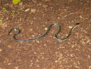
Garter Snake |
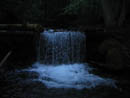
Waterfall |
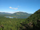
Lake Kachess |
Tiger Lilies |
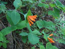
Honeysuckle |
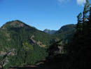
Silver Creek Valley |
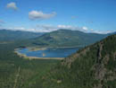
Lake Kachess |
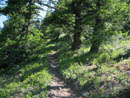
Easton Cutoff Trail |
Flowers Near Ridge |
Mt. Baldy |
Photo Page 2
Trips - 2004
Home