8-21-04
After a beautiful summer week
of 80 degree sunshine in Seattle the forecast turned to rain for the weekend.
With that in mind my sights turned east once again. Suzanne and Rick were
along for this hike starting at Cooper Lake in the Salmon La Sac area.
We arrived at 9:00 am and were soon on our way. This trail goes to ever
popular Pete Lake and it was a little surprising that there were only half
a dozen cars in the lot. I have done this loop on two other occasions but
it had been 11 years since the last time. It was a little cool at first
but very comfortable. There are (were) some berries in the first mile. They
were just about ripe. At about one mile we turned off onto the Tired Creek
Trail. The trail was just a little brushy as it crossed an open clear cut
but wasn't bad at all. When we reached the old road I noticed that there
still is no sign guiding hikers to the trail. A right turn takes you to
Tired Creek where the trail starts up again.
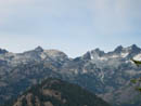
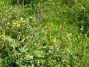
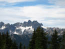
The route begins mostly in the open. Horses use the route and it's a little rocky and dusty until it settles down to switchbacks on good tread. Clouds had already begun to come in and kept the temperature at a comfortable level. Even so I was still sweating all the way up. Part way up, Mt. Rainier came into view through the trees. It was cloud free for now. At one switchback a short spur leads to nice views of Three Queens, Chikaman Peak, and Lemah Mountain. Back on the trail we climbed into the higher meadows. This is a great flower show in the spring. We had only a few asters and paintbrush left. The huckleberries more than made up for the lack of flowers. At the trail intersection we turned right for the last short climb to the old fire lookout site atop Polallie Ridge. There are no other peaks close by and this spot provides a terrific view of peaks from Rainier to Stuart, Daniel, Hinman, The Cradle, and the peaks of the Cascade crest.
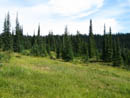
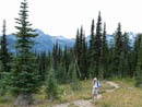
We reached the lookout at about 11:40 and had our lunch. As has been the case on most of my hikes this year there were virtually no bugs. I have been in a black cloud of bugs on this summit so it was very much appreciated. A group arrived as we were leaving. They were the first people we saw. We dropped back to the intersection and continued straight ahead on the trail down to Waptus Pass. This trail follows the top of the ridge. This is not a very often used trail but logs were freshly cut and the tread was in great shape. We gained 2600' to the lookout site and lost 1100' quickly down to Waptus Pass. All through the hike I was surprised to find so many creeks still running. We had two dogs along and they had plenty of water to drink. Water was running even near the ridge crest. North from the pass is the trail down to Waptus Lake. We took a left and headed south. The route had a number of small ups and downs in the next section. A number of brand new bridges crossed areas that would be marshy in the spring.
We reached the intersection with the trail up to Escondido Lakes and took another left. Finally we started to descend again. At a good sized creek with a small waterfall we met two horse riders heading to Deep Lake. The route began to descend somewhat steeper with many short switchbacks. In the middle of this we met another horse party coming up. We stood on the steep hillside while they took a break while blocking the trail. Not too thoughtful... We soon had a look at Pete Lake through the trees below. The clouds were now getting darker but we stayed warm and dry. I expected the crowds to begin at the lake. In fact there were several tents there and half a dozen horses. We took a break while the dogs went swimming. The mountains behind the lake were now shrouded in clouds. The rain was coming but we still had some time.
The last 4 miles of trail is the least interesting. The net loss is only 200' with a number of small ups and downs. We stayed near the river but could seldom see it. The route is mostly wide and smooth. A mile+ from the lake there was a new trail since my last visit. The main route has a sign stating that bikes can go no further and directing them onto the new trail. I guess that it likely goes up to the end of the old road we crossed on the way up. The rest of the way out was just a slog. At least there were a few berries near the end. We arrived back at the car around 4:00. By the time we reached Hyak the rain was steady and remained that way all the way to North Bend. It was nice to avoid the rain.
This is a loop with a great deal of variety. We had forest, meadows, a great view, berries, and a lake. For the first 9 miles we saw only three other groups. The climb is on a south aspect and can be very hot on many summer days. We did not have that problem. Thankfully, the clouds stayed away until after we reached the lookout sight. The views alone were worth the trip. I don't think I'll wait 11 years to return.
Click on thumbnails to get larger pictures.
Photo Page 2
Trips - 2004
Home
The route begins mostly in the open. Horses use the route and it's a little rocky and dusty until it settles down to switchbacks on good tread. Clouds had already begun to come in and kept the temperature at a comfortable level. Even so I was still sweating all the way up. Part way up, Mt. Rainier came into view through the trees. It was cloud free for now. At one switchback a short spur leads to nice views of Three Queens, Chikaman Peak, and Lemah Mountain. Back on the trail we climbed into the higher meadows. This is a great flower show in the spring. We had only a few asters and paintbrush left. The huckleberries more than made up for the lack of flowers. At the trail intersection we turned right for the last short climb to the old fire lookout site atop Polallie Ridge. There are no other peaks close by and this spot provides a terrific view of peaks from Rainier to Stuart, Daniel, Hinman, The Cradle, and the peaks of the Cascade crest.
We reached the lookout at about 11:40 and had our lunch. As has been the case on most of my hikes this year there were virtually no bugs. I have been in a black cloud of bugs on this summit so it was very much appreciated. A group arrived as we were leaving. They were the first people we saw. We dropped back to the intersection and continued straight ahead on the trail down to Waptus Pass. This trail follows the top of the ridge. This is not a very often used trail but logs were freshly cut and the tread was in great shape. We gained 2600' to the lookout site and lost 1100' quickly down to Waptus Pass. All through the hike I was surprised to find so many creeks still running. We had two dogs along and they had plenty of water to drink. Water was running even near the ridge crest. North from the pass is the trail down to Waptus Lake. We took a left and headed south. The route had a number of small ups and downs in the next section. A number of brand new bridges crossed areas that would be marshy in the spring.
We reached the intersection with the trail up to Escondido Lakes and took another left. Finally we started to descend again. At a good sized creek with a small waterfall we met two horse riders heading to Deep Lake. The route began to descend somewhat steeper with many short switchbacks. In the middle of this we met another horse party coming up. We stood on the steep hillside while they took a break while blocking the trail. Not too thoughtful... We soon had a look at Pete Lake through the trees below. The clouds were now getting darker but we stayed warm and dry. I expected the crowds to begin at the lake. In fact there were several tents there and half a dozen horses. We took a break while the dogs went swimming. The mountains behind the lake were now shrouded in clouds. The rain was coming but we still had some time.
The last 4 miles of trail is the least interesting. The net loss is only 200' with a number of small ups and downs. We stayed near the river but could seldom see it. The route is mostly wide and smooth. A mile+ from the lake there was a new trail since my last visit. The main route has a sign stating that bikes can go no further and directing them onto the new trail. I guess that it likely goes up to the end of the old road we crossed on the way up. The rest of the way out was just a slog. At least there were a few berries near the end. We arrived back at the car around 4:00. By the time we reached Hyak the rain was steady and remained that way all the way to North Bend. It was nice to avoid the rain.
This is a loop with a great deal of variety. We had forest, meadows, a great view, berries, and a lake. For the first 9 miles we saw only three other groups. The climb is on a south aspect and can be very hot on many summer days. We did not have that problem. Thankfully, the clouds stayed away until after we reached the lookout sight. The views alone were worth the trip. I don't think I'll wait 11 years to return.
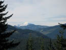
Mt. Rainier |
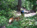
Suzanne And Co. |
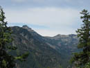
Three Queens |
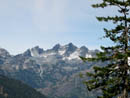
Lemah Mountain |
Chikamin And Lemah |
Flowers |
Meadow |
Rick |
Chimney Rock |
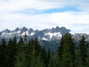
Lemah And Chimney |
Photo Page 2
Trips - 2004
Home