6-12-05
Gary and I had a great time scrambling these two
Icicle Creek peaks last summer. I didn't plan on a return trip so soon
but when I saw that Richard and Lynn were leading it as a Mountaineer
scramble I
signed up. I drove around after Saturday in the Teanaway and camped at
Rock Island campgrounds. We were to meet at 7:00 AM which proved to be
a good thing. It was overcast, cold, and misty as we set out just
before
7:30. This was a strong group with mostly experienced climbers and
scramblers.
I quickly realized I had forgotten gloves and my camera and dashed back
to my car. The gloves had mysteriously disappeared since the day before
but
I had a pair of driving gloves I grabbed. I caught up with the group at
the
first clothing break.
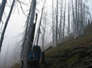
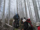
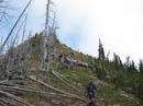
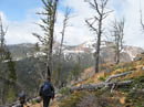
The Blackjack Ridge trail is smooth and consistently graded but also steep and relentless. There is one very short level section near the middle but otherwise it goes steeply uphill. Still, the route is so nice that it does not seem like it gains 3250' in only 3 miles. It was very cold but with a hat and gloves and the effort of getting up that trail I stayed warm enough. As we began to move out of the forest snow was falling. Not much but it was the first falling snow I had seen in months. Last year the section through a burn was awash in wildflowers. This year we were too early. The snow melt seems to be about 4 weeks ahead of schedule and we did this trip 3 weeks later last year but there were few flowers. The main one was glacier lilies. On the entire trip we crossed only a few small snow patches.
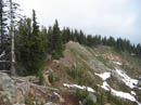
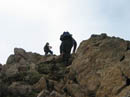
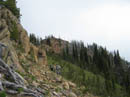
We reached the crest of Blackjack Ridge in a cold white cloud. Nearly everything was hidden by the clouds. We couldn't see the summit of Bootjack but much of the ridge was in the clear. After a short break we started up the ridge towards Bootjack. The ridge walk is mostly on grass and dirt. Only the very top has any rock scrambling and this is short and easy. For a short time a small ray of sunshine shone on us through the clouds. From the summit of Bootjack we could see Highchair. At least it was not in the clouds. The base of Stuart was discernible but most of the mountain was draped in clouds. With our early start it was only just after 10:00. At this point I realized I had managed to lose my second and last pair of gloves available for this weekend. It's a good thing my head is stuck on tight.
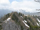
I was the only one to have done this trip so I took the lead heading down the ridge towards Highchair. I made one misstep trying to go over the first bump (around the first to the left and over the top of the second) then the route went great. We soon dropped down to the rocky ridge running over to Highchair. Some folks contoured well below the crest and some of us managed to stay on the crest nearly all the way. The clouds were now lifting and views began to improve. Once across the ridge we dropped slightly to the left into a basin. Last year it was filled with shooting stars but this year there were few flowers yet.
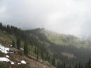
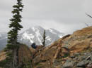
Once through the basin we headed straight up for the summit, some 800' above. We climbed some large boulders and reached the ridge top just a few hundred feet below the top. From there it was an easy walk to the 7016' summit. The wind was blowing while crossing the ridge but it was nearly calm on the summit. By the time we reached the top the clouds had lifted considerably. The Cradle was just across the valley and in the clear. It's east side was still heavily snow covered. The summit of Mt. Stuart was in the clouds but Ingalls Peaks on one side and Argonaut Peak on the other were clear. Harding Mountain is among the closest and most interesting summits we saw. I reached the summit at 12:00 and we must have spent an hour there.
Soon enough we packed up and headed down. We avoided the boulders and had an easy descent on dirt and grass back into the basin. From there we again crossed the rocky ridge and took a head count before continuing the last 600 vertical feet up the ridge and back to Bootjack. We arrived at 3:15 and a quick count showed we were two hikers short. How we lost someone on an easy grassy ridge walk was hard to figure. After 15 minutes of waiting and yelling four of us headed back down the ridge. I had already gained 5600' and did not relish dropping down once again.
With our early start we at least had a lot of daylight left. We dropped to the first bump and yelled but heard nothing. At the second bump we yelled and several of us thought we heard a very faint response. It seemed to be from farther down the ridge so on we went. We soon reached the start of the rocky ridge. Everyone had been accounted for this far coming back. A yell received a faint but definite response from even farther down the ridge. Frank and I took the lead as we rapidly scrambled back across the rocky ridge. We were most of the way across when we heard and saw our wayward twosome. They were fine and heading our way. I never did find out what possessed them to cross the ridge then turn around and head back towards Highchair. The good news was that they were fine.
The sun was now out and that last 800' back up to Bootjack for the third time was tough. We were all running out of gas. By the time we again reached Bootjack it was 5:15. Our search took two full hours. Finally we began the 3900' descent. I can't believe any of us made it down without sore legs. I reached the car at 7:15. The last people came out at 7:45. It turned out to be a little more of an adventure than I had planned on. It was nice to see Richard, Lynn, Jay, and Lindy again. After a cold and bleak start the weather was actually pretty nice most of the day. Views ended up being very good. I made it home at 10:30 after a 13 miles and 6400' gained day. It was another fun scramble.
Click on thumbnails to get larger pictures.
Photo Page 2
Trips - 2005
Home
The Blackjack Ridge trail is smooth and consistently graded but also steep and relentless. There is one very short level section near the middle but otherwise it goes steeply uphill. Still, the route is so nice that it does not seem like it gains 3250' in only 3 miles. It was very cold but with a hat and gloves and the effort of getting up that trail I stayed warm enough. As we began to move out of the forest snow was falling. Not much but it was the first falling snow I had seen in months. Last year the section through a burn was awash in wildflowers. This year we were too early. The snow melt seems to be about 4 weeks ahead of schedule and we did this trip 3 weeks later last year but there were few flowers. The main one was glacier lilies. On the entire trip we crossed only a few small snow patches.
We reached the crest of Blackjack Ridge in a cold white cloud. Nearly everything was hidden by the clouds. We couldn't see the summit of Bootjack but much of the ridge was in the clear. After a short break we started up the ridge towards Bootjack. The ridge walk is mostly on grass and dirt. Only the very top has any rock scrambling and this is short and easy. For a short time a small ray of sunshine shone on us through the clouds. From the summit of Bootjack we could see Highchair. At least it was not in the clouds. The base of Stuart was discernible but most of the mountain was draped in clouds. With our early start it was only just after 10:00. At this point I realized I had managed to lose my second and last pair of gloves available for this weekend. It's a good thing my head is stuck on tight.
I was the only one to have done this trip so I took the lead heading down the ridge towards Highchair. I made one misstep trying to go over the first bump (around the first to the left and over the top of the second) then the route went great. We soon dropped down to the rocky ridge running over to Highchair. Some folks contoured well below the crest and some of us managed to stay on the crest nearly all the way. The clouds were now lifting and views began to improve. Once across the ridge we dropped slightly to the left into a basin. Last year it was filled with shooting stars but this year there were few flowers yet.
Once through the basin we headed straight up for the summit, some 800' above. We climbed some large boulders and reached the ridge top just a few hundred feet below the top. From there it was an easy walk to the 7016' summit. The wind was blowing while crossing the ridge but it was nearly calm on the summit. By the time we reached the top the clouds had lifted considerably. The Cradle was just across the valley and in the clear. It's east side was still heavily snow covered. The summit of Mt. Stuart was in the clouds but Ingalls Peaks on one side and Argonaut Peak on the other were clear. Harding Mountain is among the closest and most interesting summits we saw. I reached the summit at 12:00 and we must have spent an hour there.
Soon enough we packed up and headed down. We avoided the boulders and had an easy descent on dirt and grass back into the basin. From there we again crossed the rocky ridge and took a head count before continuing the last 600 vertical feet up the ridge and back to Bootjack. We arrived at 3:15 and a quick count showed we were two hikers short. How we lost someone on an easy grassy ridge walk was hard to figure. After 15 minutes of waiting and yelling four of us headed back down the ridge. I had already gained 5600' and did not relish dropping down once again.
With our early start we at least had a lot of daylight left. We dropped to the first bump and yelled but heard nothing. At the second bump we yelled and several of us thought we heard a very faint response. It seemed to be from farther down the ridge so on we went. We soon reached the start of the rocky ridge. Everyone had been accounted for this far coming back. A yell received a faint but definite response from even farther down the ridge. Frank and I took the lead as we rapidly scrambled back across the rocky ridge. We were most of the way across when we heard and saw our wayward twosome. They were fine and heading our way. I never did find out what possessed them to cross the ridge then turn around and head back towards Highchair. The good news was that they were fine.
The sun was now out and that last 800' back up to Bootjack for the third time was tough. We were all running out of gas. By the time we again reached Bootjack it was 5:15. Our search took two full hours. Finally we began the 3900' descent. I can't believe any of us made it down without sore legs. I reached the car at 7:15. The last people came out at 7:45. It turned out to be a little more of an adventure than I had planned on. It was nice to see Richard, Lynn, Jay, and Lindy again. After a cold and bleak start the weather was actually pretty nice most of the day. Views ended up being very good. I made it home at 10:30 after a 13 miles and 6400' gained day. It was another fun scramble.
Lynn And Clouds |
Leaving Trail |
Ascending Ridge |
Blackjack Ridge |
Bootjack Summit |
Harding Mountain |
Leaving Bootjack |
Second Bump |
Silvered Ridge |
Highchair Ahead |
Photo Page 2
Trips - 2005
Home