11/12/05
Suzanne was interested in a snowshoe trip. The trail
up Mt. Higgins has been closed for over a year due to logging. Just last
week I saw a trip report stating the trail is back open again. Suzanne had
snowshoed up in the spring. I had only been on the trail one time
before
, in August of 2003. Suzanne was in Mt. Vernon for the evening and so
we met in Arlington and headed on in her vehicle. It was 39 degrees when
we met and very cloudy. It rained part of the way to the trailhead. There
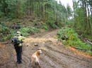
are a few new roads and other evidence of the recent logging. The road at
the trailhead is a little wider and some surrounding trees are gone.
The old trail sign is 20 vertical feet above the road with no obvious trail up to it. The road has a number of deep tank stopping trenches to keep vehicles from continuing on. The old trail was a narrowed logging road at first. They converted it back to a wide and muddy road. Proceed past the first trench then scramble up the hill to the road, just beyond the now useless trail sign.
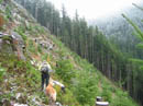
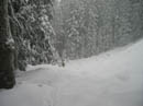
Since there were no other signs we just assumed that the road was the correct route and it was. This road also has a number of trenches that seem more designed to move water than to stop vehicles. Be prepared to drop down and then up to cross all dozen or so of the smaller trenches. The trailhead is at about 1450' and after about .60 miles and 550' gained the road returned to a trail. Very soon the trail begins to traverse up an open hillside. The views are good on a clear day down to the valley and up to Whitehorse and Three Fingers. With the low clouds and drizzle we couldn't see much of anything. There were just a few small patches of snow along here.
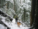
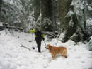
The trail proceeds to enter forest and the aesthetics improved immensely. We both began with gaiters and they soon proved useful. There was some snow and lots of running water. This old trail has a number of rotting moss covered boardwalks. They are OK on a sunny summer day but when wet they are as bad as a sheet of ice. Add a thin layer of wet snow and it's nasty. On several of them we walked in the water filled ditch along side as it was much safer. A few had a few inches of snow and it provided enough of a step to give us some traction. Before the big creek there is a tree down across the trail. We were able to get across but the trunk is several feet in diameter and when slick with snow it's not easy.
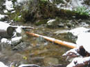
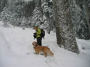
We dropped down on snow to the crossing of Dicks Creek. It's not much of a problem in mid summer but it is very high right now. It took us a while to sort through the options before we settled on the only realistic one. Up the creek was bad and down was worse. The only way across is right where the trail is. It was only some 15 or so feet from the last rock to the other side. It was very fast and deep. I went first and the water was up to the top of my gaiters. Sadie the golden retriever was the biggest concern as the water was as deep as her legs. After a little trepidation she came right across as I had one foot in the water preparing to grab her if necessary. With that out of the way we were now down to a walk in the snow.
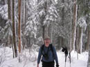
The trail parallels the creek as it quickly gains elevation. Some of the route was bare at first but soon everything was under a layer of snow. We did find one big fungus/mushroom growing right in the middle of the trail. A year and a half without boots really showed. A few more short switchbacks and the snow was deep enough for us to put on snowshoes. The creek crossing was at about 2850' and by 3100' we had on our snowshoes. Since few know that the trail has been reopened, and with the creek crossing being so difficult, we were sure that nobody would catch up to help us break trail. The trail became very hard to follow. We lost it and then found it a number of times.
We finally lost it and plowed up the most likely route. Since I had no experience on the trail in winter and little in summer I uploaded waypoints roughly every half mile into my gps. This proved useful in keeping us roughly on course. I seldom use the gps but this day it proved very helpful along with a map. We managed to work our way over to the meadows near the way trail down to Myrtle Lake. We even ran back into the trail. Staying on it proved to be short lived. Everything was flocked in white now much like on Mt. Dickerman last weekend. The snow was soft but much better compacted than last weekend. We reached waypoint 6 leaving us just .50 miles from the summit as the crow flies. Unfortunately, my watch still had us 900' below the 4849' summit.
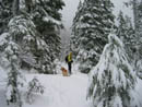
With that distance and elevation to go it obviously became very steep very fast. We slogged up the side of a snow covered open slope we both remembered as being a rock field. That allowed us to verify we were back on the summer route. The going got very steep along here. It would not have been so bad if the snow was more consolidated. We found ourselves sinking several feet deep in spots and with the steep slope it was hard to climb out and higher. Add to that the encroaching trees and tree wells and it was rough. At about 4200' and only .30 miles from the top we called it quits. Hard snow had just started too.
We dropped down to a flat spot for lunch. It took us about 4 hours to climb up 3 1/2 miles of trail and snow. Now that we had compacted steps the hike down was much faster. With the thick layer of snow on everything the silence was really amazing. Our route had included 4 or so crossings of creeks on deep snow. Most could not be jumped so we had to climb down and then back up the other side. A good wet time was had by all. When we descended back to the big creek we were prepared and this time the crossing was wet but not too bad. I was amazed to still have dry feet after several steps with water to the tops of my gaiters in both directions.
Slogging back down the last wide muddy logging road was no fun. At least the rest of the trail was not marred. Coming down took two hours or just half the time it took to hike up. Back at the trailhead we were not surprised to see no other cars. On the day we traveled just over 7 miles with about 3100' of gain with ups and downs. I'm glad to see that this trail is back in use. An easy trail hike in the summer proved to be much more of an adventure with several feet of snow.
Click on thumbnails to get larger pictures.
Photo Page 2
Trips - 2005
Home
The old trail sign is 20 vertical feet above the road with no obvious trail up to it. The road has a number of deep tank stopping trenches to keep vehicles from continuing on. The old trail was a narrowed logging road at first. They converted it back to a wide and muddy road. Proceed past the first trench then scramble up the hill to the road, just beyond the now useless trail sign.
Since there were no other signs we just assumed that the road was the correct route and it was. This road also has a number of trenches that seem more designed to move water than to stop vehicles. Be prepared to drop down and then up to cross all dozen or so of the smaller trenches. The trailhead is at about 1450' and after about .60 miles and 550' gained the road returned to a trail. Very soon the trail begins to traverse up an open hillside. The views are good on a clear day down to the valley and up to Whitehorse and Three Fingers. With the low clouds and drizzle we couldn't see much of anything. There were just a few small patches of snow along here.
The trail proceeds to enter forest and the aesthetics improved immensely. We both began with gaiters and they soon proved useful. There was some snow and lots of running water. This old trail has a number of rotting moss covered boardwalks. They are OK on a sunny summer day but when wet they are as bad as a sheet of ice. Add a thin layer of wet snow and it's nasty. On several of them we walked in the water filled ditch along side as it was much safer. A few had a few inches of snow and it provided enough of a step to give us some traction. Before the big creek there is a tree down across the trail. We were able to get across but the trunk is several feet in diameter and when slick with snow it's not easy.
We dropped down on snow to the crossing of Dicks Creek. It's not much of a problem in mid summer but it is very high right now. It took us a while to sort through the options before we settled on the only realistic one. Up the creek was bad and down was worse. The only way across is right where the trail is. It was only some 15 or so feet from the last rock to the other side. It was very fast and deep. I went first and the water was up to the top of my gaiters. Sadie the golden retriever was the biggest concern as the water was as deep as her legs. After a little trepidation she came right across as I had one foot in the water preparing to grab her if necessary. With that out of the way we were now down to a walk in the snow.
The trail parallels the creek as it quickly gains elevation. Some of the route was bare at first but soon everything was under a layer of snow. We did find one big fungus/mushroom growing right in the middle of the trail. A year and a half without boots really showed. A few more short switchbacks and the snow was deep enough for us to put on snowshoes. The creek crossing was at about 2850' and by 3100' we had on our snowshoes. Since few know that the trail has been reopened, and with the creek crossing being so difficult, we were sure that nobody would catch up to help us break trail. The trail became very hard to follow. We lost it and then found it a number of times.
We finally lost it and plowed up the most likely route. Since I had no experience on the trail in winter and little in summer I uploaded waypoints roughly every half mile into my gps. This proved useful in keeping us roughly on course. I seldom use the gps but this day it proved very helpful along with a map. We managed to work our way over to the meadows near the way trail down to Myrtle Lake. We even ran back into the trail. Staying on it proved to be short lived. Everything was flocked in white now much like on Mt. Dickerman last weekend. The snow was soft but much better compacted than last weekend. We reached waypoint 6 leaving us just .50 miles from the summit as the crow flies. Unfortunately, my watch still had us 900' below the 4849' summit.
With that distance and elevation to go it obviously became very steep very fast. We slogged up the side of a snow covered open slope we both remembered as being a rock field. That allowed us to verify we were back on the summer route. The going got very steep along here. It would not have been so bad if the snow was more consolidated. We found ourselves sinking several feet deep in spots and with the steep slope it was hard to climb out and higher. Add to that the encroaching trees and tree wells and it was rough. At about 4200' and only .30 miles from the top we called it quits. Hard snow had just started too.
We dropped down to a flat spot for lunch. It took us about 4 hours to climb up 3 1/2 miles of trail and snow. Now that we had compacted steps the hike down was much faster. With the thick layer of snow on everything the silence was really amazing. Our route had included 4 or so crossings of creeks on deep snow. Most could not be jumped so we had to climb down and then back up the other side. A good wet time was had by all. When we descended back to the big creek we were prepared and this time the crossing was wet but not too bad. I was amazed to still have dry feet after several steps with water to the tops of my gaiters in both directions.
Slogging back down the last wide muddy logging road was no fun. At least the rest of the trail was not marred. Coming down took two hours or just half the time it took to hike up. Back at the trailhead we were not surprised to see no other cars. On the day we traveled just over 7 miles with about 3100' of gain with ups and downs. I'm glad to see that this trail is back in use. An easy trail hike in the summer proved to be much more of an adventure with several feet of snow.
Road/Trail |
On Trail |
Snowy Trail |
Dicks Creek |
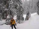
Suzanne & Sadie |
Jim |
Untracked Snow |
Big Tree |
Heading Down |
Snowing |
Photo Page 2
Trips - 2005
Home