11-19-05
I had the good fortune to get out for a snowshoe trip
with two folks I knew through nwhikers.net. Richard (Naturealbeing) and
Jeff (Hichen) proved to be a lot of fun to hike with. We chose a close in
hike I had not done in half a dozen years and which they had never done.
Mt. Washington is across the valley from Mailbox Peak and just east of Rattlesnake
Mountain. We met at the Exit 38 trailhead at 7:30 am. Not surprisingly
there were no other cars. The Puget Sound Basin has been under an inversion
layer of fog and smog for nearly a week. The thick dark layer ended just
before North Bend and we had blue skies and sunshine. Although there was
little snow visible above we chose to take our snowshoes just in case. By
about 7:45 we were on our way.
The Mt. Washington trail beginning is just off the Iron Horse trail and is not signed. It is visible if you are looking for it and it quickly becomes apparent that it is a real trail. The route mostly follows old road beds with trail sections connecting them. The grade is consistent and it didn't seem that steep but the elevation gain came pretty quickly. Climbers have discovered the rock faces along the route and now use the trail extensively. When I first hiked this trail 15+ years ago it was virtually unknown. Several of the rock faces right along the trail had climbing bolts easily visible.
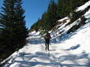
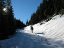
The trailhead is at about 1200'. We still had not seen snow as we neared 3000'. There is one junction along the lower trail. Both look to be well used trails. I don't remember seeing it on my last visit. It seemed like we needed to be farther to the right and that turned out to be correct. I don't know if the other trail goes to a climbing area. We did not see a trail meeting up with our route higher up. It had been very windy at the trailhead but it was totally calm once in the forest. In fact it was getting down right warm. We reached snow at about 3300' and a few hundred feet higher Richard and I donned gaiters and snowshoes.
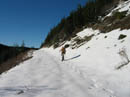
We soon reached a level road going both ways. Take a left turn here. A short distance along we came out on a more major road. We followed the road as it traversed around the east side of the mountain. There are few trees up here and the views are outstanding from the Cascade Crest, down the valley of the North Fork Snoqualmie River, and up the Middle Fork. The snow was a little soft but much more consolidated than what I slogged through the previous two weekends. As we came around the south side and onto the east side we were suddenly in the sunshine. It was bright and warm. It may be late November but it felt like spring. I expected it to be pleasant but I was overdressed for the heat.
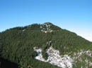
Before reaching the sun Jeff donned his snowshoes and we continued higher. From the east side we were looking right across to McClellan Butte. Now behind us was Mailbox Peak. The road continued to climb then dropped slightly to where the road was blasted from the top of the ridge as it crosses the Great Wall. Once across we climbed up to the ridge top. A road goes north and south along the ridge top. We turned right heading towards the summit. The Cedar River Watershed is on the other side of the ridge. "No Trespassing" signs are posted every 50 feet or so all along the road.
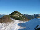
The road crosses to the right side of the ridge at a notch. The summit route begins to climb up the ridge from here. The first part of the ridge was bare dirt so we took off our snowshoes. It's only about 250' from there to the roughly 4400' summit. Summit views are terrific. Below we could see the low fog/smog layer covering the lowlands. Mt. Baker and Glacier Peak were bright white with fresh snow to the north. Hibox and Alta Mountain appeared through a low gap in the crest. The Olympics were crystal clear. Best of all, it was warm on top. My thermometer only read about 52 degrees but in the bright sun it felt like 65. There may have been wind at the bottom but it was dead calm the whole time we were on the summit.
None of us had any desire to quickly return to the dark smoggy city so we had a good long stay on top. In fact we were up there for a full two hours. Jeff made a climb to the real summit, the top of a weather station tower. He was comfortable on top with no shirt and I was in short sleeves. It was 1:30 before we finally decided to head on down. As we recrossed the Great Wall we saw the only other hikers of the day. A couple were postholing in our snowshoe tracks. They had no snowshoes, no heavier boots, and a small day pack and fanny pack between them. If they continued to the summit they would be coming down in the dark.
The descent on snowshoes was plodding but the views were again excellent. I had to stop a number of times to take photos. Once we took off our snowshoes the pace picked up considerably. Richard and Jeff motored down the trail and I did my best to keep up. Even at what felt like a good pace it still took us well over 2 hours to reach the bottom. As we emerged from the forest back onto the Iron Horse trail we were accosted by a stiff and very cold wind. We went from spring back to late November in a matter of a few feet.
This turned out to be a great trip. Good snow conditions, great views, very warm weather, and best of all great company. Washington makes for a good close in hike good for about 10 miles with 3400' gained. It was a great day not to be stuck in the dark smoggy city.
Click on thumbnails to get larger pictures.
Photo Page 2
Trips - 2005
Home
The Mt. Washington trail beginning is just off the Iron Horse trail and is not signed. It is visible if you are looking for it and it quickly becomes apparent that it is a real trail. The route mostly follows old road beds with trail sections connecting them. The grade is consistent and it didn't seem that steep but the elevation gain came pretty quickly. Climbers have discovered the rock faces along the route and now use the trail extensively. When I first hiked this trail 15+ years ago it was virtually unknown. Several of the rock faces right along the trail had climbing bolts easily visible.
The trailhead is at about 1200'. We still had not seen snow as we neared 3000'. There is one junction along the lower trail. Both look to be well used trails. I don't remember seeing it on my last visit. It seemed like we needed to be farther to the right and that turned out to be correct. I don't know if the other trail goes to a climbing area. We did not see a trail meeting up with our route higher up. It had been very windy at the trailhead but it was totally calm once in the forest. In fact it was getting down right warm. We reached snow at about 3300' and a few hundred feet higher Richard and I donned gaiters and snowshoes.
We soon reached a level road going both ways. Take a left turn here. A short distance along we came out on a more major road. We followed the road as it traversed around the east side of the mountain. There are few trees up here and the views are outstanding from the Cascade Crest, down the valley of the North Fork Snoqualmie River, and up the Middle Fork. The snow was a little soft but much more consolidated than what I slogged through the previous two weekends. As we came around the south side and onto the east side we were suddenly in the sunshine. It was bright and warm. It may be late November but it felt like spring. I expected it to be pleasant but I was overdressed for the heat.
Before reaching the sun Jeff donned his snowshoes and we continued higher. From the east side we were looking right across to McClellan Butte. Now behind us was Mailbox Peak. The road continued to climb then dropped slightly to where the road was blasted from the top of the ridge as it crosses the Great Wall. Once across we climbed up to the ridge top. A road goes north and south along the ridge top. We turned right heading towards the summit. The Cedar River Watershed is on the other side of the ridge. "No Trespassing" signs are posted every 50 feet or so all along the road.
The road crosses to the right side of the ridge at a notch. The summit route begins to climb up the ridge from here. The first part of the ridge was bare dirt so we took off our snowshoes. It's only about 250' from there to the roughly 4400' summit. Summit views are terrific. Below we could see the low fog/smog layer covering the lowlands. Mt. Baker and Glacier Peak were bright white with fresh snow to the north. Hibox and Alta Mountain appeared through a low gap in the crest. The Olympics were crystal clear. Best of all, it was warm on top. My thermometer only read about 52 degrees but in the bright sun it felt like 65. There may have been wind at the bottom but it was dead calm the whole time we were on the summit.
None of us had any desire to quickly return to the dark smoggy city so we had a good long stay on top. In fact we were up there for a full two hours. Jeff made a climb to the real summit, the top of a weather station tower. He was comfortable on top with no shirt and I was in short sleeves. It was 1:30 before we finally decided to head on down. As we recrossed the Great Wall we saw the only other hikers of the day. A couple were postholing in our snowshoe tracks. They had no snowshoes, no heavier boots, and a small day pack and fanny pack between them. If they continued to the summit they would be coming down in the dark.
The descent on snowshoes was plodding but the views were again excellent. I had to stop a number of times to take photos. Once we took off our snowshoes the pace picked up considerably. Richard and Jeff motored down the trail and I did my best to keep up. Even at what felt like a good pace it still took us well over 2 hours to reach the bottom. As we emerged from the forest back onto the Iron Horse trail we were accosted by a stiff and very cold wind. We went from spring back to late November in a matter of a few feet.
This turned out to be a great trip. Good snow conditions, great views, very warm weather, and best of all great company. Washington makes for a good close in hike good for about 10 miles with 3400' gained. It was a great day not to be stuck in the dark smoggy city.
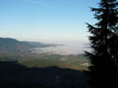
Smog Below |
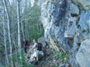
Mt. Washington Trail |
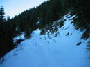
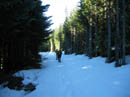
On Snow |
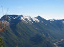
Mt. Defiance |
Naturealbeing |
Hichen In The Sun |
Summit |
Looking Back |
Nearing Ridge |
Ridge Top |
Photo Page 2
Trips - 2005
Home