10/06-08/06
Last week I had a terrific larch backpacking trip
to Wing Lake
in the North Cascades. Could I have sunny weather two weeks in a row
this late in the year? Gary was free for this trip. We met Friday in Bothell
at 12:50 in the afternoon. We had no traffic problems and reached the Phelps
Creek Trailhead, up the Chiwawa River Road, at 3:20. By 3:50 we were on
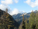
the trail. It was cloudy most of the way over but we had some blue sky as
we started out. In just a few short minutes we reached the Carne Mountain
junction. Now I was on another trail new to me. Gary has been to Carne Basin
a number of times but it had been 18 years since he took the high route.
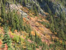
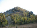
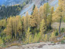
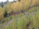
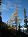
The trail is well graded. We started with 3 hours of daylight and 2600' to gain. The trailhead is at 3500' and the basin is at 6100'. The way is mostly in forest before finally breaking out into the open. We saw some brightly colored mountain ash then saw the first golden larch higher above. They were the first of about 10,000 larch we were to see. After 1 1/2 hours of hiking we broke into Carne Basin. We could see one tent across the basin and an open site near the creek at the start of the basin.
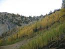
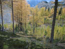
It only took us about 15 minutes to set up camp and hang our food. We still had over an hour of sun left so we went for a walk. Many of the larch trees were already in the shade. We crossed the basin and followed the trail higher. We did get up to where we could photograph some sun drenched larch trees. It was shorts and short sleeves on the hike up but it began to cool very quickly. We took the Old Gib trail to the saddle and it was blowing fairly hard. Too cold to stay long. Nice views out to Old Gib and larch lined ridges in the distance.
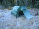
We retreated back to camp for dinner just before dark. The weather report was for a chance of rain or snow this evening, sunny weather on Saturday, and overcast but dry for Sunday. Since it was October, we would be camping two nights over 6000', and the forecast was a little uncertain, we took Gary's Hilleberg Nallo 2. Solid four season protection and about the same weight as two tarptents. It turned out to be a very good choice.
When the sun set it turned very cold very fast. Gary pumped water out of my water bag at 7:30. Thirty minutes later I went to do the same. Nothing came out. Both inlet and outlet hoses had frozen solid. I had to take off the hoses and use body heat to melt the ice enough to blow it out. Hmm... the forecast was for a low of about 32 degrees. We were below that at 8:00 pm. By 8:30 the tent had lots of white frost on it.
Just before 9:00 the darkness was pierced by a ball of light. There was a full harvest moon rising above the ridge. It became so light we walked across the basin meadow with no headlamps. It was very bright. We cast long "moon shadows" across the meadow. When the cold became a bit much for us it was time to turn in. It was so light in the tent I could read my LCD watch without the backlight. Thankfully we were prepared for the cold. My 10 degree bag kept me warm all night. In the morning, the water bottle I had in the tent had no traces of ice. While it was likely down to at least 20 degrees overnight it was not below 32 in the tent. The two of us in a small 2 man tent with a fly to the ground really were much warmer than outside.
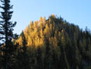
We were not anxious to brave the cold the next morning. At least we were at the far west end of the basin and received the earliest sun. When I did climb out I could see that the valley bottom had light before we did. Thirty seconds without gloves had us on the way to frostbite so they had to go on and off with each photo. The sky was solid blue as promised. We had breakfast and headed off to photograph the larch.
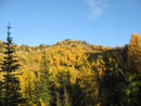
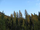
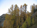
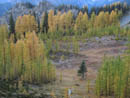
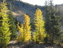
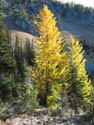
Carne Basin is made up almost entirely of larch trees. For those few weeks of the year when they are at their peak it is ablaze with color. Many trees were at their peak and some were still a little green. Hardly any had begun to lose their needles. It was about 8:30 before the sun reached out tent. We spent a lot more time taking photos. By the time we had packed up to leave it was nearly 11:30. Our original plan was to take the high route to the saddle south of Mt. Maude, climb it, and drop down to Ice Lakes east of the pass or to the basin to the west to camp.
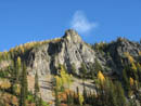
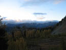
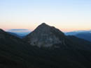
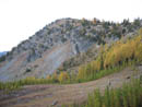
Our late start made that plan more difficult but I would not have missed spending time photographing larch to get in Maude. The mountain will always be there but a day with peaking larch and blue sky in October is very rare. We hiked up to the ridge top at slow speed as there was so much to see and photograph along the way. At the saddle we dropped our packs and continued up to the summit of 7085' Carne Mountain. The views were outstanding. Maude was right there. Glacier Peak came partly into view. Clark, Buck, Berge, Cleator, Flower Dome, Fortress, Chiwawa, and Red were lined up to the west. There were a few clouds over there but sunny sky everywhere else.
Gary pointed out the route he had taken 18 years before. It is a little higher than what is on his old USGS map but looked like a reasonable route to me. On our way down from the summit we met a couple of backpackers heading up. At the saddle we headed down into the valley of Rock Creek. This section has lots of larch trees as well. We crossed over a pass at 6600' and dropped into the valley of Box Creek. The route remained easy to follow. We descended slowly reaching Box Creek.
We pumped water here. There are a couple large horse camps here. The route disappeared in meadow across the creek. we followed near the left side of the creek heading higher and the trail picked up once again. It turned to the left and climbed out of the meadow. We soon left the trail and climbed up to a higher larch filled meadow. We dropped down and climbed again to a pass where a track was found. Here we were surprised to find three hikers coming over in the other direction. Even more surprising was when one called me by name. I met John some years ago. They were doing our route in reverse, with a climb of Maude, in one day. That is a killer day hike. They were in good spirits and had some info to share with us.
They continued on with about 3 hours of daylight left to cover quite a bit of trail. We contoured high above a basin through open slopes and stands of larch. It was very beautiful as was most all the route that day. We climbed to one more pass over boulders then grass and scree. From there, at 7400', we could see the basin below us and next to Leroy Basin. A sketchy route crossed loose rock to the pass South of Maude and just 400' above Upper Ice Lake. Now we had a decision to make. In the 2+ hours of daylight left we could cross to the pass, climb Maude, and descend to Ice Lake or to the west. Likely we could do it before dark. The basin to the west was filled with larch trees. Which way to go?
As we pondered, the couple from Carne Mountain, who we had also seen at Box Creek, now caught up with us. They chose to cross to the pass across and below Maude. We chose to descend to the basin below us and west of the pass. As loose as the traverse to the pass looked, dropping down was worse. We made sure not to be above each other as many rocks came cascading down as we descended. There was even some snow still surviving below the saddle. Once down in the basin we needed to find water.
We passed half a dozen dry creek beds. One had some water but it was frozen solid. We dropped lower than we had planned and finally found a good creek bubbling up out of the ground. A short trail from the creek led to a campsite. We planned to set up camp and use the remaining light to photograph the numerous larch trees. If the weather was good in the morning we would get up early and climb Maude.
We spent some time photographing. We were even able to come very near a woodpecker low down in a tree. Unfortunately, low clouds to the west reduced our sunlight well before the sun neared the horizon. Oh well... The normal route up Maude was obvious right above us. We camped at 6800' leaving about 2300' of gain to the summit plus about 100' of descent on the other side of the pass. We went to bed hoping for one more day of clear skies.
Sometime around 10:00 pm Gary suddenly noticed there was no moonlight in the tent. Not a good omen. I woke up a number of times during the night. On most of them I heard the sound of rain on the tent. It was much warmer with the cloud cover but thoughts of Maude began to slip away. I awoke to the sound of something sloughing off the tent. Rain doesn't slough off. I poked my head out to see low clouds around us and white on the ground. Not a lot of snow but more higher up. I had no desire to get up early to climb up a steep dirt and rock slope with a thin coating of wet snow to get to a frozen summit with no views. Maude could wait for another day.
The rain would stop for a few minutes then start up again. We only had 7 miles to get out so an early start was not a necessity. Gary was more interested than me in getting going and he packed up first. The tent was a little cramped so he went first. Once the sleeping pads were stowed we were committed. The ground was too cold to stay in the tent. By some dumb luck, the rain stopped as I was finishing packing. Even better, it was done for the rest of the trip. Most of the snow was gone at our elevation as the warmer morning rain had melted it.
We packed and had lunch for breakfast. I did not want to take the time to cook while the rain was stopped. We had an easy short climb to the saddle above Leroy Basin. The ground was frozen here and a little overnight snow was still on the ground north of the pass. The descent is steep but easy to follow. For a while that is. As we reached a rocky basin below the trail suddenly disappeared entirely. From the saddle we saw the deep new gully carved out a few years ago. We knew that had to be crossed and the best place is where the trail crosses. Cross country did not seem to be a good way to find that spot.
We headed farther down and did find a cairn then another. There were signs of footprints but not even an indistinct path. Gary felt the route likely contoured much higher on our right. We were about to climb back up when Gary spotted a possible path. I headed over and it did begin to look like a path. We chose to follow it farther down. It looked like a real trail for a moment as it descended a gully to a meadow. There it completely disappeared.
We chose to traverse to our right and slightly higher. This brought us to the new gully...very near cairns showing the crossing spot. We found nothing like a bootpath nearby. The gully walls are very steep. The crossing spot was an easy descent and climb out. Most anywhere else would be very difficult. On the other side the bootpath quickly ended. We chose to climb up the side of the gully looking for the old trail. We climbed about 250 vertical feet. I was ready to just head off cross country to Leroy Basin. At that point Gary saw a cairn and we climbed up to the trail. It was much farther up than I was expecting.
We finally had some confidence in the weather and stripped out of rain gear. Now on real tread we had an easy hike over to the top of the basin. We continued to hike through a forest of larch trees. Once in the basin we looked up at Seven Fingered Jack. It was entirely in the clouds. There was a tiny patch of blue heading that way so we waited until we had a look at the summits shrouded in thin clouds. We found no tents in the basin. The rest of the hike out was just a slog. Steep down to the Phelps Creek Trail then very gentle back to the car. We did see three groups hiking in or sitting by the trail.
This was a spectacular backpacking trip. A day and a half of peaking larch and blue sky. A night of rain and snow. A night that was horribly cold. A meadow walk by moonlight. A fun cross country leg. More color than a decade of normal Octobers. Although the numbers show only 15 miles with 6000' gained this was much more difficult than a normal trail hike. There was scree, boulders, narrow trail, and non existent trail. I have been truly fortunate to have had two sunny backpacks with peaking larch trees in one year.
Click on thumbnails to get larger pictures.
Photo Page 2
Trips - 2006
Home
The trail is well graded. We started with 3 hours of daylight and 2600' to gain. The trailhead is at 3500' and the basin is at 6100'. The way is mostly in forest before finally breaking out into the open. We saw some brightly colored mountain ash then saw the first golden larch higher above. They were the first of about 10,000 larch we were to see. After 1 1/2 hours of hiking we broke into Carne Basin. We could see one tent across the basin and an open site near the creek at the start of the basin.
It only took us about 15 minutes to set up camp and hang our food. We still had over an hour of sun left so we went for a walk. Many of the larch trees were already in the shade. We crossed the basin and followed the trail higher. We did get up to where we could photograph some sun drenched larch trees. It was shorts and short sleeves on the hike up but it began to cool very quickly. We took the Old Gib trail to the saddle and it was blowing fairly hard. Too cold to stay long. Nice views out to Old Gib and larch lined ridges in the distance.
We retreated back to camp for dinner just before dark. The weather report was for a chance of rain or snow this evening, sunny weather on Saturday, and overcast but dry for Sunday. Since it was October, we would be camping two nights over 6000', and the forecast was a little uncertain, we took Gary's Hilleberg Nallo 2. Solid four season protection and about the same weight as two tarptents. It turned out to be a very good choice.
When the sun set it turned very cold very fast. Gary pumped water out of my water bag at 7:30. Thirty minutes later I went to do the same. Nothing came out. Both inlet and outlet hoses had frozen solid. I had to take off the hoses and use body heat to melt the ice enough to blow it out. Hmm... the forecast was for a low of about 32 degrees. We were below that at 8:00 pm. By 8:30 the tent had lots of white frost on it.
Just before 9:00 the darkness was pierced by a ball of light. There was a full harvest moon rising above the ridge. It became so light we walked across the basin meadow with no headlamps. It was very bright. We cast long "moon shadows" across the meadow. When the cold became a bit much for us it was time to turn in. It was so light in the tent I could read my LCD watch without the backlight. Thankfully we were prepared for the cold. My 10 degree bag kept me warm all night. In the morning, the water bottle I had in the tent had no traces of ice. While it was likely down to at least 20 degrees overnight it was not below 32 in the tent. The two of us in a small 2 man tent with a fly to the ground really were much warmer than outside.
We were not anxious to brave the cold the next morning. At least we were at the far west end of the basin and received the earliest sun. When I did climb out I could see that the valley bottom had light before we did. Thirty seconds without gloves had us on the way to frostbite so they had to go on and off with each photo. The sky was solid blue as promised. We had breakfast and headed off to photograph the larch.
Carne Basin is made up almost entirely of larch trees. For those few weeks of the year when they are at their peak it is ablaze with color. Many trees were at their peak and some were still a little green. Hardly any had begun to lose their needles. It was about 8:30 before the sun reached out tent. We spent a lot more time taking photos. By the time we had packed up to leave it was nearly 11:30. Our original plan was to take the high route to the saddle south of Mt. Maude, climb it, and drop down to Ice Lakes east of the pass or to the basin to the west to camp.
Our late start made that plan more difficult but I would not have missed spending time photographing larch to get in Maude. The mountain will always be there but a day with peaking larch and blue sky in October is very rare. We hiked up to the ridge top at slow speed as there was so much to see and photograph along the way. At the saddle we dropped our packs and continued up to the summit of 7085' Carne Mountain. The views were outstanding. Maude was right there. Glacier Peak came partly into view. Clark, Buck, Berge, Cleator, Flower Dome, Fortress, Chiwawa, and Red were lined up to the west. There were a few clouds over there but sunny sky everywhere else.
Gary pointed out the route he had taken 18 years before. It is a little higher than what is on his old USGS map but looked like a reasonable route to me. On our way down from the summit we met a couple of backpackers heading up. At the saddle we headed down into the valley of Rock Creek. This section has lots of larch trees as well. We crossed over a pass at 6600' and dropped into the valley of Box Creek. The route remained easy to follow. We descended slowly reaching Box Creek.
We pumped water here. There are a couple large horse camps here. The route disappeared in meadow across the creek. we followed near the left side of the creek heading higher and the trail picked up once again. It turned to the left and climbed out of the meadow. We soon left the trail and climbed up to a higher larch filled meadow. We dropped down and climbed again to a pass where a track was found. Here we were surprised to find three hikers coming over in the other direction. Even more surprising was when one called me by name. I met John some years ago. They were doing our route in reverse, with a climb of Maude, in one day. That is a killer day hike. They were in good spirits and had some info to share with us.
They continued on with about 3 hours of daylight left to cover quite a bit of trail. We contoured high above a basin through open slopes and stands of larch. It was very beautiful as was most all the route that day. We climbed to one more pass over boulders then grass and scree. From there, at 7400', we could see the basin below us and next to Leroy Basin. A sketchy route crossed loose rock to the pass South of Maude and just 400' above Upper Ice Lake. Now we had a decision to make. In the 2+ hours of daylight left we could cross to the pass, climb Maude, and descend to Ice Lake or to the west. Likely we could do it before dark. The basin to the west was filled with larch trees. Which way to go?
As we pondered, the couple from Carne Mountain, who we had also seen at Box Creek, now caught up with us. They chose to cross to the pass across and below Maude. We chose to descend to the basin below us and west of the pass. As loose as the traverse to the pass looked, dropping down was worse. We made sure not to be above each other as many rocks came cascading down as we descended. There was even some snow still surviving below the saddle. Once down in the basin we needed to find water.
We passed half a dozen dry creek beds. One had some water but it was frozen solid. We dropped lower than we had planned and finally found a good creek bubbling up out of the ground. A short trail from the creek led to a campsite. We planned to set up camp and use the remaining light to photograph the numerous larch trees. If the weather was good in the morning we would get up early and climb Maude.
We spent some time photographing. We were even able to come very near a woodpecker low down in a tree. Unfortunately, low clouds to the west reduced our sunlight well before the sun neared the horizon. Oh well... The normal route up Maude was obvious right above us. We camped at 6800' leaving about 2300' of gain to the summit plus about 100' of descent on the other side of the pass. We went to bed hoping for one more day of clear skies.
Sometime around 10:00 pm Gary suddenly noticed there was no moonlight in the tent. Not a good omen. I woke up a number of times during the night. On most of them I heard the sound of rain on the tent. It was much warmer with the cloud cover but thoughts of Maude began to slip away. I awoke to the sound of something sloughing off the tent. Rain doesn't slough off. I poked my head out to see low clouds around us and white on the ground. Not a lot of snow but more higher up. I had no desire to get up early to climb up a steep dirt and rock slope with a thin coating of wet snow to get to a frozen summit with no views. Maude could wait for another day.
The rain would stop for a few minutes then start up again. We only had 7 miles to get out so an early start was not a necessity. Gary was more interested than me in getting going and he packed up first. The tent was a little cramped so he went first. Once the sleeping pads were stowed we were committed. The ground was too cold to stay in the tent. By some dumb luck, the rain stopped as I was finishing packing. Even better, it was done for the rest of the trip. Most of the snow was gone at our elevation as the warmer morning rain had melted it.
We packed and had lunch for breakfast. I did not want to take the time to cook while the rain was stopped. We had an easy short climb to the saddle above Leroy Basin. The ground was frozen here and a little overnight snow was still on the ground north of the pass. The descent is steep but easy to follow. For a while that is. As we reached a rocky basin below the trail suddenly disappeared entirely. From the saddle we saw the deep new gully carved out a few years ago. We knew that had to be crossed and the best place is where the trail crosses. Cross country did not seem to be a good way to find that spot.
We headed farther down and did find a cairn then another. There were signs of footprints but not even an indistinct path. Gary felt the route likely contoured much higher on our right. We were about to climb back up when Gary spotted a possible path. I headed over and it did begin to look like a path. We chose to follow it farther down. It looked like a real trail for a moment as it descended a gully to a meadow. There it completely disappeared.
We chose to traverse to our right and slightly higher. This brought us to the new gully...very near cairns showing the crossing spot. We found nothing like a bootpath nearby. The gully walls are very steep. The crossing spot was an easy descent and climb out. Most anywhere else would be very difficult. On the other side the bootpath quickly ended. We chose to climb up the side of the gully looking for the old trail. We climbed about 250 vertical feet. I was ready to just head off cross country to Leroy Basin. At that point Gary saw a cairn and we climbed up to the trail. It was much farther up than I was expecting.
We finally had some confidence in the weather and stripped out of rain gear. Now on real tread we had an easy hike over to the top of the basin. We continued to hike through a forest of larch trees. Once in the basin we looked up at Seven Fingered Jack. It was entirely in the clouds. There was a tiny patch of blue heading that way so we waited until we had a look at the summits shrouded in thin clouds. We found no tents in the basin. The rest of the hike out was just a slog. Steep down to the Phelps Creek Trail then very gentle back to the car. We did see three groups hiking in or sitting by the trail.
This was a spectacular backpacking trip. A day and a half of peaking larch and blue sky. A night of rain and snow. A night that was horribly cold. A meadow walk by moonlight. A fun cross country leg. More color than a decade of normal Octobers. Although the numbers show only 15 miles with 6000' gained this was much more difficult than a normal trail hike. There was scree, boulders, narrow trail, and non existent trail. I have been truly fortunate to have had two sunny backpacks with peaking larch trees in one year.
First View Out |
First Color |
Larch Above |
Golden Basin |
Dull In The Shade |
Blue Sky |
Cloudy To The West |
Green & Gold |
Basin From Ridge |
Old Gib |
Still Light In Basin |
Descending |
Red, Green, & Gold |
Carne Mountain |
Carne Basin |
First Light |
Frosty |
Sunny Day |
Light At Camp |
Afire |
Photo Page 2
Trips - 2006
Home