4-22-06
Suzanne joined me for a second attempt at
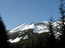
Humpback Mountain
. Back in late January we battled deep snow, route finding errors,
and time. The Seahawks NFC Championship game was on in the afternoon.
We made it part way up the ridge before heading down. Kolleen and Bob
had since summited but had poor views. Suzanne and I decided to try again.
The forecast was for all day sunshine and considerable avalanche danger.
The ridge is forested all the way up with minimal avalanche danger. The
danger was forecast to increase as the day went on so we left Seattle just
after 7:00 AM.
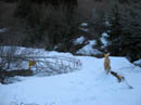
On our previous attempt we were able to drive to a little before the Iron Horse Trail trestle. This time we drove nearly a mile farther. The road was snow free to over 2200' then quickly covered the road. We parked just before the road turned sharply to the left at about 2400'. The road was snow covered with intermittent bare spots. The lower road from which the bottom of the Humpback ridge trail starts was bare. We switched back to the right now on solid and rock hard snow. It was about 30 degrees when we started at 8:15.
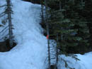
It didn't take long to reach the gated left turn to intersect the trail on the ridge. The snow was still so hard we didn't even leave any footprints. I was beginning to wonder if we should have brought crampons along. On our previous trip we slowly walked around the nose of the ridge looking for pink tape marking the trail. Four of us saw none. Perhaps it was the snow depth. This time Suzanne had no difficulty finding it. The first section above the road is newer dense forest. It is a little tough to work through.
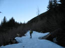
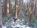
The trail was covered with rock hard icy snow but we managed to keep on it. At first there were flags periodically though they stopped a ways up the ridge. Footing was lousy but we managed to get through with minimal underbrush problems. Near 4000', after gaining 800' from the road, we broke out into older forest. Now the underbrush and closely spaced trees were no longer a problem. The icy snow finally was too much for me and I stopped to put on snowshoes. I needed the extra traction.
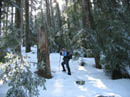
From this point we were above our earlier trip high point. The ridge was now easy climbing. Within 100' of putting on snowshoes traction improved markedly. There was a little soft snow on top of the hard. The broad ridge began to narrow but remained easy to ascend. At times we dropped a little off the crest to find easier terrain. The northeast ridge began to close in as it neared our northwest ridge. At one point we had a view of the summit. It was not far away but still well above us.
Nearly every report I read mentioned the last 50+ feet are very steep. They are. Suzanne put on snowshoes higher on the ridge and now we stopped to consider the last climb. I dumped a pole and took out my ice axe. Suzanne held Sadie the golden retriever while I took a stab at the top. The snow was still very hard but my snowshoe crampons grabbed well. I traversed to the right and headed straight up a gap in the trees. At this point I really wished I had on crampons and not snowshoes. The last 20 feet was the worst as the snow was bulletproof.
I crested the ridge hoping that it was not knife edge. In fact there was room for several dozen people right there. The ridge then narrowed reaching the summit within a short distance. I called down to Suzanne and she let Sadie go. She ran up the slope in a matter of seconds. I found a better approach near the top and her crampon claws did just fine. Suzanne then joined us on top. The view 75 feet below the summit was of Mt. Rainier. At the top it was 360 degrees of fantastic.
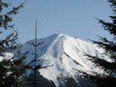
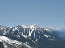
Down the valley was Mt. Si and the lowlands. North were numerous peaks including the top of Glacier Peak. Mt. Stuart rose well above smaller peaks. Silver, Tinkham, and Abiel were across the bowl of snow covered Annette Lake. Many peaks of the Cascade crest were in view. There was not a cloud in the sky. The temperature was low but the sun and lack of wind made it seem very warm. I made a short trip over to the actual 5174' summit. It was maybe 10' higher than our ridge top lunch spot. It took us about 3 hours to reach the top. The ice lower on the ridge slowed us down a good deal.
After lunch I descended face in kicking steps down the slope. The ice had softened enough to kick into but it was still very hard. When I reached reasonable terrain I stopped and Suzanne let Sadie go. She came down easily and Suzanne followed. Snowshoes went on and we had an easy romp down the upper ridge. When the dense forest began again we tried to find our route up. Our boots left almost no marks and we could not find the route.
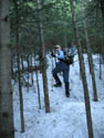
We stayed near the ridge crest and began bushwhacking. This is exactly what we did on our previous trip. It was a challenge to find small gaps in the dense trees to slip through. At least it was not as hard as in the morning. We kept snowshoes on for the traction though. I stopped to take a photo of Suzanne fighting her way through and a few minutes later I noticed my new camera was gone! Between the last photo and then it had come out as I slipped and slid down the slope.
The chances of finding it in dense forest on hard snow were minimal. I went back up and did not see it. After reaching a spot near where I took the photo we headed down one more time. It could be in a tree well or it could have skidded far out of sight. As we made it back to where I noticed it was gone I acknowledged that it was gone for good. Suzanne took one last look and there it was. A real needle in a haystack.
Some more slipping, sliding, and falling and we dropped back down to the road. The rest of the slog down was easy enough. A couple of guys with no snowshoes ran by us and another solo hiker arrived as we were leaving. The trip was fun and we did gain 2800' on snow but it was still early. As we reached North Bend I suggested we take a quick trip up Cedar Butte. The cars were parked a long way down the road from the Rattlesnake Lake lot. We took a short cut to the Iron Horse Trail.
Now we had on shorts and it felt like spring at last. We saw only one person on the Cedar Butte trail and there was no snow or ice at all. For the day we covered about 9 miles with 3800' gained. I want to check out Humpback in the summer but the view is really great with snow. This is a low avalanche danger scramble with 360 degree views. I'll be back next winter.
Click on thumbnails to get larger pictures.
Photo Page 2
Trips - 2006
Home
On our previous attempt we were able to drive to a little before the Iron Horse Trail trestle. This time we drove nearly a mile farther. The road was snow free to over 2200' then quickly covered the road. We parked just before the road turned sharply to the left at about 2400'. The road was snow covered with intermittent bare spots. The lower road from which the bottom of the Humpback ridge trail starts was bare. We switched back to the right now on solid and rock hard snow. It was about 30 degrees when we started at 8:15.
It didn't take long to reach the gated left turn to intersect the trail on the ridge. The snow was still so hard we didn't even leave any footprints. I was beginning to wonder if we should have brought crampons along. On our previous trip we slowly walked around the nose of the ridge looking for pink tape marking the trail. Four of us saw none. Perhaps it was the snow depth. This time Suzanne had no difficulty finding it. The first section above the road is newer dense forest. It is a little tough to work through.
The trail was covered with rock hard icy snow but we managed to keep on it. At first there were flags periodically though they stopped a ways up the ridge. Footing was lousy but we managed to get through with minimal underbrush problems. Near 4000', after gaining 800' from the road, we broke out into older forest. Now the underbrush and closely spaced trees were no longer a problem. The icy snow finally was too much for me and I stopped to put on snowshoes. I needed the extra traction.
From this point we were above our earlier trip high point. The ridge was now easy climbing. Within 100' of putting on snowshoes traction improved markedly. There was a little soft snow on top of the hard. The broad ridge began to narrow but remained easy to ascend. At times we dropped a little off the crest to find easier terrain. The northeast ridge began to close in as it neared our northwest ridge. At one point we had a view of the summit. It was not far away but still well above us.
Nearly every report I read mentioned the last 50+ feet are very steep. They are. Suzanne put on snowshoes higher on the ridge and now we stopped to consider the last climb. I dumped a pole and took out my ice axe. Suzanne held Sadie the golden retriever while I took a stab at the top. The snow was still very hard but my snowshoe crampons grabbed well. I traversed to the right and headed straight up a gap in the trees. At this point I really wished I had on crampons and not snowshoes. The last 20 feet was the worst as the snow was bulletproof.
I crested the ridge hoping that it was not knife edge. In fact there was room for several dozen people right there. The ridge then narrowed reaching the summit within a short distance. I called down to Suzanne and she let Sadie go. She ran up the slope in a matter of seconds. I found a better approach near the top and her crampon claws did just fine. Suzanne then joined us on top. The view 75 feet below the summit was of Mt. Rainier. At the top it was 360 degrees of fantastic.
Down the valley was Mt. Si and the lowlands. North were numerous peaks including the top of Glacier Peak. Mt. Stuart rose well above smaller peaks. Silver, Tinkham, and Abiel were across the bowl of snow covered Annette Lake. Many peaks of the Cascade crest were in view. There was not a cloud in the sky. The temperature was low but the sun and lack of wind made it seem very warm. I made a short trip over to the actual 5174' summit. It was maybe 10' higher than our ridge top lunch spot. It took us about 3 hours to reach the top. The ice lower on the ridge slowed us down a good deal.
After lunch I descended face in kicking steps down the slope. The ice had softened enough to kick into but it was still very hard. When I reached reasonable terrain I stopped and Suzanne let Sadie go. She came down easily and Suzanne followed. Snowshoes went on and we had an easy romp down the upper ridge. When the dense forest began again we tried to find our route up. Our boots left almost no marks and we could not find the route.
We stayed near the ridge crest and began bushwhacking. This is exactly what we did on our previous trip. It was a challenge to find small gaps in the dense trees to slip through. At least it was not as hard as in the morning. We kept snowshoes on for the traction though. I stopped to take a photo of Suzanne fighting her way through and a few minutes later I noticed my new camera was gone! Between the last photo and then it had come out as I slipped and slid down the slope.
The chances of finding it in dense forest on hard snow were minimal. I went back up and did not see it. After reaching a spot near where I took the photo we headed down one more time. It could be in a tree well or it could have skidded far out of sight. As we made it back to where I noticed it was gone I acknowledged that it was gone for good. Suzanne took one last look and there it was. A real needle in a haystack.
Some more slipping, sliding, and falling and we dropped back down to the road. The rest of the slog down was easy enough. A couple of guys with no snowshoes ran by us and another solo hiker arrived as we were leaving. The trip was fun and we did gain 2800' on snow but it was still early. As we reached North Bend I suggested we take a quick trip up Cedar Butte. The cars were parked a long way down the road from the Rattlesnake Lake lot. We took a short cut to the Iron Horse Trail.
Now we had on shorts and it felt like spring at last. We saw only one person on the Cedar Butte trail and there was no snow or ice at all. For the day we covered about 9 miles with 3800' gained. I want to check out Humpback in the summer but the view is really great with snow. This is a low avalanche danger scramble with 360 degree views. I'll be back next winter.
Some photos courtesy of Suzanne Hartman
Upper Gate |
Blue Sky |
Nearing Ridge |
Granite Mountain |
Route Marker |
Ridge Trail |
Forest Opens |
Jim Slipping Along |

Mt. Rainier |
McClellan Butte |
Photo Page 2
Trips - 2006
Home