7/03-06/06
Gary and I had discussed this hike several years ago.
We finally found the time to make it happen. Gary had been through Park
Creek Pass 28 years ago and I had never been up the Thunder Creek Trail
beyond the turn off to Fourth Of July Pass. We headed out of Seattle a
little after 3:00 pm on Thursday to battle traffic. The North Cascades National
Park ranger station in Marblemount closes at 6:00 on Thursday so we had
to hope for no big traffic problems. In fact, the drive went fine and we
were there by 5:30. We planned on getting up the valley as quickly as possible.
There were available sites at Skagit Queen camp at 13 miles and also Thunder
Basin hiker camp at 17 miles. We chose Thunder Basin for 2 nights. We also
grabbed a spot at Thunder Camp 1.8 miles up the trail for Thursday night.
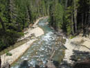
After dinner in Marblemount we were off to Colonial Creek Campgrounds and the trailhead. At 7:15 we were packed up and on the trail. Since the flood of 2003 the trail has been rerouted and a new bridge is in place farther up Thunder Creek. Within 30 minutes we were at the bridge. The old suspension bridge was washed away by the flood. The new bridge is wood over several long steel I-beams. Thunder Camp is right across the bridge. We immediately found that the 1.8 miles to camp was really about 1.2 miles. We had a few other surprises in store on our hike up. A closer look at the map would have been very helpful.
We saw two other hikers at the camp. We would see only 4 others until near the end of our trip. I had a chance to try out my new Tarptent Rainbow. It was easy to set up and worked very well the whole trip. Gary has a Tarptent Squall and the higher headroom of the Rainbow led to much less condensation inside on several windless nights. We were soon in bed and ready for a very strenuous day coming up.
Day 1
We were up and on the trail by 8:50 am. In hindsight we should have started earlier. Oh well... The trailhead is at 1200'. The elevation of Thunder Basin hiker camp was not listed. We guestimated it to be about 5000'. Park Creek Pass is at 6040'. We knew there was a descent from Junction Camp before the final climb up the valley. We did not count on all the ups and downs along the way. We expected about 4500' of gain. It turned out to be 5800'. That and 16 miles to camp. And the brush. And the ford. It was a long day.
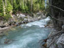
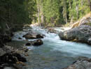
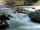
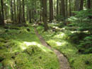
The day was mostly sunny but with some clouds all day. The trail is almost entirely in forest for the first 14 miles. Thankfully, it was warm but not hot. We powered along the trail at a good clip as the tread is good and it is fairly level except for the fore mentioned ups and downs. We quickly reached the turn off for Fourth Of July Pass and Neve camp was not much farther. The forest is carpeted in green. We found much of the way to be completely moss covered. The creek is sometimes close by and sometimes not.
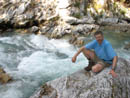
The section up to McAllister Creek camp has no great views or other features. It is just a nice forest walk. Just before McAllister the trail comes close to the creek and we found a nice big rock jutting out into the creek. This makes a great rest stop. The creek is narrow and wild through here. You can see McAllister Creek joining Thunder Creek just upstream. Back under way we came to a bridge over the creek. This is the way to McAllister hiker camp. McAllister is at about 5.7 miles from the trailhead.
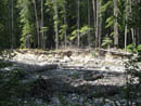
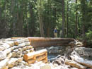
Beyond McAllister is about 1 1/2 more miles of forest walk to Fisher Creek. This bridge was also washed away by the flood. The new bridge is another steel I-beam monster. The aftermath of the flood is impressive as rocks and trees are strewn around a much wider cut than the current creek bed. Shortly after the bridge is Tricouni camp. After that the fun begins. The trail climbs steeply along Fisher Creek from 2000' to 3100' at Junction camp.
Junction camp is 9 miles from the trailhead and 9 miles from Park Creek Pass. We found a nice spot along the creek to eat lunch and to pump more water. We now had 8 miles down with 8 miles to go. Shortly beyond camp is the intersection with the Fisher Creek Trail. We stayed right on the Thunder Creek Trail. We soon passed an unmarked trail down 1000' to Thunder Creek. Our trail also began to descend. Over about 2 miles the route drops from near 3200' to 2300'. Eleven miles in and we were only 1100' above the trailhead. We still had 4000' to climb to camp, plus more ups and downs, in the last 5 miles.
From the bottom we began to climb again. In two more miles we reached Skagit Queen camp at 3200'. Just before it is a terrific two plunge waterfall. We crossed a bridge above the falls to the right side of the creek. A little past the camp we came to mining remnants from the Skagit Queen mine. I can't imagine how they lugged that heavy machinery up there. The trail then begins a series of gently graded switchbacks as the route climbs up to the upper basin. We crossed an old metal pipe several times. There were many small trees down across the trail, most from Skagit Queen camp to Park Creek Pass. Most were easy to get over. 4 or 5 were larger. One on the switchbacks above Skagit Queen would stop all horses.
Gary had been vacationing in Europe most of the previous month and had only been able to get in one strenuous hike before the trip. On those switchbacks it finally took a toll. We kept moving but our progress was definitely labored. At the top of the switchbacks we again neared the creek and found a great rest spot. The next 1 1/2+ miles to Thunder Basin horse camp was tough. The route went from forest to open meadows and back. The meadows are very overgrown. Often we could not see our feet. In places it was more than 6 feet high. Following the route in these spots is part skill and part patience. Gary managed to keep us on route. I was in bare legs and Gary had on long pants. I had the fun of discovering that these meadows are full of nettles.
We kept expecting to cross back over the creek but instead we had more thick meadows to fight through. Finally the trail turned to the creek and there was no bridge. A nice wide ford was all we had. A quick look up and downstream did not help so we took off our boots and waded the ice cold water. On the other side is Thunder Basin horse camp. I crossed first and headed downstream. I shortly found a log bridge sitting 25' from the creek. The flood even devastated the creek near it's source.
We now knew we had only 1.2 miles to camp. More high brush awaited us though not as bad as lower down. We were running on fumes at this point and it was now 6:20. We marched higher and at long last reached camp at 7:00 pm. With our stops it took just over 10 hours. Although we were "only" 3900' above the trailhead we gained 5800'. Tents went up, food was hung, we had dinner, and it was off to bed.
Day 2
With all the hard work out of the way we planned to have an easy day exploring around Park Creek Pass. Our campsite was near Thunder Creek which we could now jump across it was so small. We took our time in the morning not getting on the trail until after 9:30 am. It is one mile to the pass with about 900' of gain. The trail climbs gently in meadows to the end of the basin then climbs in many switchbacks to the pass. The first section is rapidly being lost to encroaching brush. We again encountered head high brush and small slide alder trees growing in the trail. It would be a shame to see the upper trail lost to brush.
Once across that the trail is in excellent shape as it climbs to the pass. At one switchback we found the remains of an old cabin. Above that we were startled to see a buck walking down the trail right towards us. He came within 20' before heading down the slope. That was a pleasant surprise. I few minutes later we met 2 hikers coming over the pass. Nearing the pass we found a rock basin with the start of the climbers trail to Mt. Logan. We considered that as a side scramble on the way back. Although we were still on the west side of the crest we encountered larch trees just before the pass. The trail does not go down to the pass itself. The pass is still snow covered. Instead it traverses through the pass at a higher level. Views to the south added to great views to the north. Mt. Buckner sat above our camp and seemed very close now.
The ridge on both side of the pass climbs steeply. On the east side is Storm King Mountain To the west is Point 6980. Looking up, that appeared to be a fun scramble. The main trail crosses to the west side of the pass below the snow. A side trail heads off west through meadows to a number of tarns. We followed the side trail a short way and then headed straight up the slope. This did prove to be a fun scramble. We had open slopes, some rock scrambling, and some small dense trees to avoid when possible and climb through when necessary. In relatively short order we topped out on the summit.
It is a spectacular place to enjoy an afternoon. We would see 18 miles down the valley to where we began. Ruby Mountain and Sourdough Mountain sat near the trailhead. It was only two weeks earlier I sat on top of Sourdough and looked over here. We sat at about 7000' and were surrounded by 8000' to 9000'+ peaks. Buckner was now just down the ridge from us. The huge north wall of Booker loomed across the valley. We could see the South and Middle peaks of Logan but not the real summit. It was hazy to the south although we could see Bonanza. We had some bugs in camp and they were also all the way up on this summit. Not horrible but annoying.
We spent well over 2 hours on the summit. Park Creek Pass is beautiful. The meadow and tarns would be a worthwhile destination. Neither of them compare to the view from our little scramble perch. There is another point next on the ridge which is about the same elevation. Another one is 200' higher. Both look to be easy scrambles. After them comes Buckner. We were happy to stay put and relax rather than heading off to bag more peaks.
Gary went over to a viewpoint of the saddle between us and the next point. In the gap was a weird sight. The snow had largely melted leaving about a 20' long snow arch. Beyond the arch was a 1000' drop down to the basin below. The center of the arch could not have been more than 10 inches thick. Unlike the day before this day had not a cloud in the sky. In fact I laid down in the shade of a short scruffy tree to get some shade. After our long summit stay we headed on down.
Rather than retrace our steps we decided to go down a grassy gully to the west. It had the bonus of a snow slope for a standing glissade. Farther down we could not tell if it dropped all the way to the tarns below or if it turned cliffy. Instead of continuing to drop we turned left and contoured around Point 6980. This proved to be some more fun scrambling. It was mostly rocky. We crossed one ridge then another and another still. We dropped into a grassy gully that did go down but we opted to cross one more ridge and managed to get back on our ascent route.
We dropped down earlier and onto the snow at the real Park Creek Pass. Across the snow we climbed back up to the trail and headed down. The hike back to camp was pleasant and uneventful. The pass and points south were full of small flies. To the north it was mosquitos. I found long pants, a jacket, and a head net made being in camp tolerable. After dinner we went to hang our food. As Gary tied on the line our new friend the stag walked right up behind him. He was within 20' when I pointed him out to Gary. This guy did not seem to care much about us.
We hung our food and went for cameras. He proceeded to spend a long time grazing all around our site. It was getting dark but we each took a few dozen close up photos. I see many female deer on the trail but very few bucks. This guy was up close and personal. After all that excitement it was time for bed and the long hike out the next day.
Day 3
We were up at 6:00 am but it was still 7:40 before we were packed up and on the trail. Gary was dreading the ice cold ford and I was not looking forward to all the brush. Neither proved to be much of a problem. We had 17 miles to travel with 5800' of descent and some 2000' of gain. The going started slowly. The creek forms a waterfall just below our campsite. We stopped to take more photos. In fact we stopped a lot to take photos. The brush was wet with dew and we had on rain pants. They were soaked in no time. The steep trail and brush proved to be time consuming. We reached the ford, 1.2 miles, in nearly 40 minutes.
This time we scouted downstream a little more thoroughly. We found one high log and a low one. Gary scampered across the low one using branches to pull himself up on the other side. I followed suit. So much for another ford. We put a small log across the trail to alert hikers coming up. It is not at all obvious that this is a crossing. The next section was more waist to head high wet brush interspersed with nice forest trail. It was rocky and we could often not see our feet. This made for slow progress. At long last we reached the top of the switchbacks. Now we took off rain pants and convertible pant legs to get down to short sleeves and shorts.
The switchbacks are gently graded and easy walking. Gary noticed an old steeper trail. We crossed it many times. At some point the route was completely redone through here. When we reached the old mining relics we stopped for a more thorough look. Remains of the building are still jumbled with some of the machinery. At Skagit Queen camp we looked at some campsites. It is in deep forest. At 13 miles in it would be a more sensible first day destination for many hikers. We stopped again at the waterfall just below the bridge over the creek. You must scramble down the slope a little to get a clear view of it through the trees.
Next was the rest of the drop back to 2300'. Then came the 2 mile uphill climb. It was getting much hotter this day. We stopped at a number of creeks to soak our shirts to keep cool. In fact, we kept this up all the way back. Back at Skagit Queen I was dismayed to find we had taken 2:45 to descend the first 4.1 miles. Brush and photos had slowed us down. From there we had made an effort to pick up the pace. At the top of the climb we stopped at Junction camp again. Eight miles down and nine to go. The drop to Fisher Creek bridge was much faster. At McAllister hiker camp we crossed the bridge to check out the campsites. They are far apart and quite nice.
We stopped again at the rock jutting out into the creek located below the camp. From there it was a death march out. The next 4 miles to Neve camp we covered at nearly 3 1/2 mph. We soon crossed the bridge and flew down the last 1.2 miles to the trailhead arriving just after 5:00 pm.
This really proved to be a spectacular backpacking trip. We covered a mile the first night then 37 more totalling 10,000' gained over the next three days. Having only a 21 lb. pack plus 4 lbs more of water, camera, and snacks in a fanny pack made the distance reasonable. The basin is very pretty. The pass is better and the view from Point 6980 was spectacular. We had one easy day and two long hard ones. It's a grind to get to the pass but well worth it. This was a sunny August weekend and we were the only people in the basin other than the one couple passing through. Solditude and scenery pretty well sums up our trip. I hope the Park Service can find the time to get up there and log and brush out the trail. It would be a shame if the brush hides such a beautiful place.
Click on thumbnails to get larger pictures.
Photo Page 2
Trips - 2006
Home
After dinner in Marblemount we were off to Colonial Creek Campgrounds and the trailhead. At 7:15 we were packed up and on the trail. Since the flood of 2003 the trail has been rerouted and a new bridge is in place farther up Thunder Creek. Within 30 minutes we were at the bridge. The old suspension bridge was washed away by the flood. The new bridge is wood over several long steel I-beams. Thunder Camp is right across the bridge. We immediately found that the 1.8 miles to camp was really about 1.2 miles. We had a few other surprises in store on our hike up. A closer look at the map would have been very helpful.
We saw two other hikers at the camp. We would see only 4 others until near the end of our trip. I had a chance to try out my new Tarptent Rainbow. It was easy to set up and worked very well the whole trip. Gary has a Tarptent Squall and the higher headroom of the Rainbow led to much less condensation inside on several windless nights. We were soon in bed and ready for a very strenuous day coming up.
Day 1
We were up and on the trail by 8:50 am. In hindsight we should have started earlier. Oh well... The trailhead is at 1200'. The elevation of Thunder Basin hiker camp was not listed. We guestimated it to be about 5000'. Park Creek Pass is at 6040'. We knew there was a descent from Junction Camp before the final climb up the valley. We did not count on all the ups and downs along the way. We expected about 4500' of gain. It turned out to be 5800'. That and 16 miles to camp. And the brush. And the ford. It was a long day.
The day was mostly sunny but with some clouds all day. The trail is almost entirely in forest for the first 14 miles. Thankfully, it was warm but not hot. We powered along the trail at a good clip as the tread is good and it is fairly level except for the fore mentioned ups and downs. We quickly reached the turn off for Fourth Of July Pass and Neve camp was not much farther. The forest is carpeted in green. We found much of the way to be completely moss covered. The creek is sometimes close by and sometimes not.
The section up to McAllister Creek camp has no great views or other features. It is just a nice forest walk. Just before McAllister the trail comes close to the creek and we found a nice big rock jutting out into the creek. This makes a great rest stop. The creek is narrow and wild through here. You can see McAllister Creek joining Thunder Creek just upstream. Back under way we came to a bridge over the creek. This is the way to McAllister hiker camp. McAllister is at about 5.7 miles from the trailhead.
Beyond McAllister is about 1 1/2 more miles of forest walk to Fisher Creek. This bridge was also washed away by the flood. The new bridge is another steel I-beam monster. The aftermath of the flood is impressive as rocks and trees are strewn around a much wider cut than the current creek bed. Shortly after the bridge is Tricouni camp. After that the fun begins. The trail climbs steeply along Fisher Creek from 2000' to 3100' at Junction camp.
Junction camp is 9 miles from the trailhead and 9 miles from Park Creek Pass. We found a nice spot along the creek to eat lunch and to pump more water. We now had 8 miles down with 8 miles to go. Shortly beyond camp is the intersection with the Fisher Creek Trail. We stayed right on the Thunder Creek Trail. We soon passed an unmarked trail down 1000' to Thunder Creek. Our trail also began to descend. Over about 2 miles the route drops from near 3200' to 2300'. Eleven miles in and we were only 1100' above the trailhead. We still had 4000' to climb to camp, plus more ups and downs, in the last 5 miles.
From the bottom we began to climb again. In two more miles we reached Skagit Queen camp at 3200'. Just before it is a terrific two plunge waterfall. We crossed a bridge above the falls to the right side of the creek. A little past the camp we came to mining remnants from the Skagit Queen mine. I can't imagine how they lugged that heavy machinery up there. The trail then begins a series of gently graded switchbacks as the route climbs up to the upper basin. We crossed an old metal pipe several times. There were many small trees down across the trail, most from Skagit Queen camp to Park Creek Pass. Most were easy to get over. 4 or 5 were larger. One on the switchbacks above Skagit Queen would stop all horses.
Gary had been vacationing in Europe most of the previous month and had only been able to get in one strenuous hike before the trip. On those switchbacks it finally took a toll. We kept moving but our progress was definitely labored. At the top of the switchbacks we again neared the creek and found a great rest spot. The next 1 1/2+ miles to Thunder Basin horse camp was tough. The route went from forest to open meadows and back. The meadows are very overgrown. Often we could not see our feet. In places it was more than 6 feet high. Following the route in these spots is part skill and part patience. Gary managed to keep us on route. I was in bare legs and Gary had on long pants. I had the fun of discovering that these meadows are full of nettles.
We kept expecting to cross back over the creek but instead we had more thick meadows to fight through. Finally the trail turned to the creek and there was no bridge. A nice wide ford was all we had. A quick look up and downstream did not help so we took off our boots and waded the ice cold water. On the other side is Thunder Basin horse camp. I crossed first and headed downstream. I shortly found a log bridge sitting 25' from the creek. The flood even devastated the creek near it's source.
We now knew we had only 1.2 miles to camp. More high brush awaited us though not as bad as lower down. We were running on fumes at this point and it was now 6:20. We marched higher and at long last reached camp at 7:00 pm. With our stops it took just over 10 hours. Although we were "only" 3900' above the trailhead we gained 5800'. Tents went up, food was hung, we had dinner, and it was off to bed.
Day 2
With all the hard work out of the way we planned to have an easy day exploring around Park Creek Pass. Our campsite was near Thunder Creek which we could now jump across it was so small. We took our time in the morning not getting on the trail until after 9:30 am. It is one mile to the pass with about 900' of gain. The trail climbs gently in meadows to the end of the basin then climbs in many switchbacks to the pass. The first section is rapidly being lost to encroaching brush. We again encountered head high brush and small slide alder trees growing in the trail. It would be a shame to see the upper trail lost to brush.
Once across that the trail is in excellent shape as it climbs to the pass. At one switchback we found the remains of an old cabin. Above that we were startled to see a buck walking down the trail right towards us. He came within 20' before heading down the slope. That was a pleasant surprise. I few minutes later we met 2 hikers coming over the pass. Nearing the pass we found a rock basin with the start of the climbers trail to Mt. Logan. We considered that as a side scramble on the way back. Although we were still on the west side of the crest we encountered larch trees just before the pass. The trail does not go down to the pass itself. The pass is still snow covered. Instead it traverses through the pass at a higher level. Views to the south added to great views to the north. Mt. Buckner sat above our camp and seemed very close now.
The ridge on both side of the pass climbs steeply. On the east side is Storm King Mountain To the west is Point 6980. Looking up, that appeared to be a fun scramble. The main trail crosses to the west side of the pass below the snow. A side trail heads off west through meadows to a number of tarns. We followed the side trail a short way and then headed straight up the slope. This did prove to be a fun scramble. We had open slopes, some rock scrambling, and some small dense trees to avoid when possible and climb through when necessary. In relatively short order we topped out on the summit.
It is a spectacular place to enjoy an afternoon. We would see 18 miles down the valley to where we began. Ruby Mountain and Sourdough Mountain sat near the trailhead. It was only two weeks earlier I sat on top of Sourdough and looked over here. We sat at about 7000' and were surrounded by 8000' to 9000'+ peaks. Buckner was now just down the ridge from us. The huge north wall of Booker loomed across the valley. We could see the South and Middle peaks of Logan but not the real summit. It was hazy to the south although we could see Bonanza. We had some bugs in camp and they were also all the way up on this summit. Not horrible but annoying.
We spent well over 2 hours on the summit. Park Creek Pass is beautiful. The meadow and tarns would be a worthwhile destination. Neither of them compare to the view from our little scramble perch. There is another point next on the ridge which is about the same elevation. Another one is 200' higher. Both look to be easy scrambles. After them comes Buckner. We were happy to stay put and relax rather than heading off to bag more peaks.
Gary went over to a viewpoint of the saddle between us and the next point. In the gap was a weird sight. The snow had largely melted leaving about a 20' long snow arch. Beyond the arch was a 1000' drop down to the basin below. The center of the arch could not have been more than 10 inches thick. Unlike the day before this day had not a cloud in the sky. In fact I laid down in the shade of a short scruffy tree to get some shade. After our long summit stay we headed on down.
Rather than retrace our steps we decided to go down a grassy gully to the west. It had the bonus of a snow slope for a standing glissade. Farther down we could not tell if it dropped all the way to the tarns below or if it turned cliffy. Instead of continuing to drop we turned left and contoured around Point 6980. This proved to be some more fun scrambling. It was mostly rocky. We crossed one ridge then another and another still. We dropped into a grassy gully that did go down but we opted to cross one more ridge and managed to get back on our ascent route.
We dropped down earlier and onto the snow at the real Park Creek Pass. Across the snow we climbed back up to the trail and headed down. The hike back to camp was pleasant and uneventful. The pass and points south were full of small flies. To the north it was mosquitos. I found long pants, a jacket, and a head net made being in camp tolerable. After dinner we went to hang our food. As Gary tied on the line our new friend the stag walked right up behind him. He was within 20' when I pointed him out to Gary. This guy did not seem to care much about us.
We hung our food and went for cameras. He proceeded to spend a long time grazing all around our site. It was getting dark but we each took a few dozen close up photos. I see many female deer on the trail but very few bucks. This guy was up close and personal. After all that excitement it was time for bed and the long hike out the next day.
Day 3
We were up at 6:00 am but it was still 7:40 before we were packed up and on the trail. Gary was dreading the ice cold ford and I was not looking forward to all the brush. Neither proved to be much of a problem. We had 17 miles to travel with 5800' of descent and some 2000' of gain. The going started slowly. The creek forms a waterfall just below our campsite. We stopped to take more photos. In fact we stopped a lot to take photos. The brush was wet with dew and we had on rain pants. They were soaked in no time. The steep trail and brush proved to be time consuming. We reached the ford, 1.2 miles, in nearly 40 minutes.
This time we scouted downstream a little more thoroughly. We found one high log and a low one. Gary scampered across the low one using branches to pull himself up on the other side. I followed suit. So much for another ford. We put a small log across the trail to alert hikers coming up. It is not at all obvious that this is a crossing. The next section was more waist to head high wet brush interspersed with nice forest trail. It was rocky and we could often not see our feet. This made for slow progress. At long last we reached the top of the switchbacks. Now we took off rain pants and convertible pant legs to get down to short sleeves and shorts.
The switchbacks are gently graded and easy walking. Gary noticed an old steeper trail. We crossed it many times. At some point the route was completely redone through here. When we reached the old mining relics we stopped for a more thorough look. Remains of the building are still jumbled with some of the machinery. At Skagit Queen camp we looked at some campsites. It is in deep forest. At 13 miles in it would be a more sensible first day destination for many hikers. We stopped again at the waterfall just below the bridge over the creek. You must scramble down the slope a little to get a clear view of it through the trees.
Next was the rest of the drop back to 2300'. Then came the 2 mile uphill climb. It was getting much hotter this day. We stopped at a number of creeks to soak our shirts to keep cool. In fact, we kept this up all the way back. Back at Skagit Queen I was dismayed to find we had taken 2:45 to descend the first 4.1 miles. Brush and photos had slowed us down. From there we had made an effort to pick up the pace. At the top of the climb we stopped at Junction camp again. Eight miles down and nine to go. The drop to Fisher Creek bridge was much faster. At McAllister hiker camp we crossed the bridge to check out the campsites. They are far apart and quite nice.
We stopped again at the rock jutting out into the creek located below the camp. From there it was a death march out. The next 4 miles to Neve camp we covered at nearly 3 1/2 mph. We soon crossed the bridge and flew down the last 1.2 miles to the trailhead arriving just after 5:00 pm.
This really proved to be a spectacular backpacking trip. We covered a mile the first night then 37 more totalling 10,000' gained over the next three days. Having only a 21 lb. pack plus 4 lbs more of water, camera, and snacks in a fanny pack made the distance reasonable. The basin is very pretty. The pass is better and the view from Point 6980 was spectacular. We had one easy day and two long hard ones. It's a grind to get to the pass but well worth it. This was a sunny August weekend and we were the only people in the basin other than the one couple passing through. Solditude and scenery pretty well sums up our trip. I hope the Park Service can find the time to get up there and log and brush out the trail. It would be a shame if the brush hides such a beautiful place.
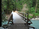
First Bridge |
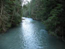
Thunder Creek |
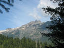
View Out |
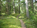
Carpet Of Green |
Narrow And Deep |
Break Time |
Jim By The Creek |
McAllister Ck Joins |
Flood Damage |
Above The Creek |
Fisher Ck Bridge |
Mossy Ground |
Glacier View |
Ice Cave |
Mining Relics |
Photo Page 2
Trips - 2006
Home