9/11-13/06
When my brother moved to Sun Valley, ID a few years
ago it opened up the opportunity to visit and also explore the mountains
of Central Idaho. Last year it did not work out but I more than made up
for that this year. My plan was to visit just after Labor Day. The theory
was that the crowds would be gone as well as the bugs. The weather would
be good but not too hot. I might even get some fall color. I hit the jackpot
on all those points.
My one concern was coming from sea level and then hiking between 6500' and almost 10,000' with a full backpack. I flew in to Hailey on Saturday. On Sunday my brother and I went for an 18 mile bike ride. The old railroad grade from Ketchum to Hailey has a slight descent as it goes south but is nearly level. I was pleased to ride at 15 - 20 mph all the way. If I could do that at 5500' it looked good for the higher mountains.
One nice benefit of having relatives there is that I had transportation out and back. Sawtooth trailheads are only about an hour from Sun Valley. That's about the same as the distance from Seattle to Snoqualmie Pass. With that in mind I pieced together a 30 mile one way traverse from Pettit Lake at about 7000' to Redfish Lake at 6547'. It ended with an 8 minute boat ride the last 4+ miles down Redfish Lake. These are busy trails in the summer but I hoped to see far less people this time of year. My route passed 12 named lakes and half a dozen unnamed ones.
Day 1
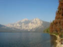
My sister in law graciously agreed to ferry me out to Pettit Lake. We crossed over Galena Summit and could immediately see smoke from fires in the Sawtooth Valley. This was another fear I had. My last few hikes in Washington were marred by smoke making for less than perfect photos. When we arrived at Pettit Lake there was no smoke overhead. That was promising. There were 7 cars in the lot and not one had Idaho plates. I was on my way by 9:25. It was only 40 degrees but sunny and I was fine in shorts and short sleeves. It warmed up very fast.
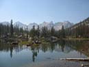
The trail follows along and above the shore of Pettit Lake. It's a good sized lake with some cabins on the other side. Within a quarter mile I reached the turn off to Yellow Belly Lake. This is the short way to my first day destination. Only 7 miles with 1400' gained gets you to 8323' Toxaway Lake. I considered that way but after doing well on the bike ride I chose the longer way instead. I turned left at the junction. A mile later I reached the Sawtooth Wilderness boundary. Here I signed in and took a permit.
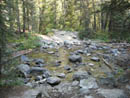
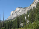
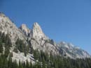
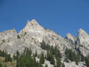
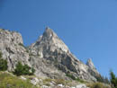
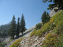
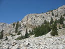
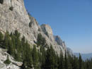
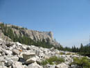
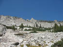
My route followed the Pettit Lake inlet creek up to Alice Lake, then Twin Lakes, over Snowyside Pass, and down to Toxaway Lake. The route crossed the creek 6 times, only once on a bridge. The water was low enough this time of year to get across them all with dry boots. I began in forest but broke out into a rocky area. The route then began to switchback up the right side of the valley. Above me was a wall of gleaming granite peaks. I saw more granite in three days than in a lifetime in the Cascades.
The day started cool but it was plenty warm climbing up those switchbacks. One thing did characterize all the trails I hiked on this trip. They are for horses and they are very gentle. I can't remember even one short stretch that exceeded a 10% grade. Considering the elevation I was not unhappy with that. The grade eased as the trail neared Alice Lake. I stopped to filter water from the creek. It is dry, especially in September, but with the lakes and running creeks I never had a problem finding water.
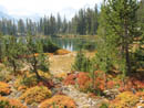
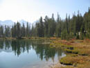
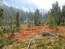
Alice Lake is at six miles. Just before it are a few neat tarns. Nice reflection shots of 10,000' mountains. I was a bit surprised to find some nice fall color here as well. This was a great place for a little break. Very quickly I reached Alice Lake at 8598'. I was only 48 hours removed from sea level but the altitude did not seem to be bothering me.
Twin Lakes sit one mile and 250' higher. The trail goes above the lakes. I took a short signed route down to near the lakes. Every single intersection I came to had signage. It would be hard to get lost there. I climbed back up to the trail for the final push to Snowyside Pass. The terrain became rockier as I left thin forest for the upper moraine. The meandering switchbacking trail works its way up to 9390' Snowyside Pass. The last part is blasted into the rock. 10,651' Snowyside Peak sits just west of the peak. It's less than 1700' to the top. I learned that this is actually just a scramble though it does not look that easy from the pass.
It was only 2:00 with three down hill miles to go so I took a full hour break just above the pass. I was on what looked to be a climbers trail heading over to Snowyside. From this viewpoint Twin Lakes were directly below me and a bit of Alice Lake was in the distance. I could now see to the north and the whole line of Sawtooth summits. It was a little hazy from distant smoke but all in all not too bad. I was sitting almost 2000' higher than glaciated Snowking Mountain , which I climbed a few weeks earlier. Quite a difference.
As much as I loved the view, by 3:00 I headed down the north side. The route is all in the rocky moraine here but still fairly smooth. I found the trails to be excellent from one end to the other, even in difficult terrain. Below me were more lakes. These are not named and small but quite nice lakes none the less. Below the lower lake I had my first look at a corner of Toxaway Lake. The trail continues descending to the right of the creek. Where it crosses near the valley bottom the creek flows down over granite slabs.
The trail goes to the west of the lake then along the north shore. It is in forest and the lake is below out of sight. At the first obvious trail heading down I turned off the main trail. In a short distance I found a large campsite and another tent not far away. I did not want to intrude but also did not want to hike back up and hope for another site. Nobody else had signed in this day on my trail so the other cars likely went the short route and were already at the lake.
I set up camp, hung my food bag, and had dinner. It had been a very nice day on the trail. I said hello to my neighbor and it turned out he works for the forest service. Ed proved to be a good source of info on the rest of my route and good company to boot. It was at least 75 degrees when I arrived but began to cool quickly as the sun set. The forecast low for Stanley, down in the valley, was 24 degrees but we were much warmed up high. Still, I was glad to have enough clothes to bundle up.
I brought along my Tarptent Rainbow. I have been able to manage condensation in the Cascades by leaving half the front beak open all night. These mountains are much dryer and I experimented by sealing up the tent completely. In the morning I found not a drop of condensation on anything. Sunset was very nice down the lake. For the day I hiked 11 miles with about 2500' gained.
Day 2
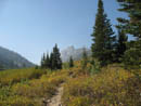
The day dawned cold but not frigid. Like the day before it warmed rapidly. By 9:45 when I started hiking I was back to shorts and short sleeves. The trail continued along the lake to the junction with the trail to Toxaway Divide and Edna Lake. It began with more long gentle switchbacks as it rose above the lake. It is 2.1 miles with 1000' gained to the roughly 9300' pass. Much of the way is in the open with great views to the south.
Nearing the pass I met a couple from Wisconsin who had backpacked to Edna Lake. They were returning via Snowyside Pass which we could see from there. I soon arrived at Toxaway Divide. My trail headed down to Edna and another trail headed up then down to Enid and Imogene Lakes. I noticed a climbers track heading up the to the left of the pass. I dropped my pack and climbed the 150' to the top. I could see much of the rest of my route for the day. Cramer Peak stood out. I guessed correctly where Hidden Lake was located.
I dropped back to the pass and headed down towards another good sized unnamed lake. Near the lake I met a hiker from Boise and then a couple. The descent to Edna went quickly. It's about two miles. Edna is another good sized lake. The trail drops right to the shore. I took advantage of this to filter more water. A lone fisherman was out in a small raft.
From Edna the route drops to Virginia Lake at 8254'. The trail follows along the side of the South Fork of the Payette River. Where I crossed it the width was about 10 feet. Now it was time to switch gears for the last climb of the trip. The trail climbs 1300' to Cramer Divide at about 9500'. As I had seen before, vegetation changes from 8000' to over 9000'. Forest gives way to granite and grass with some trees. Near the passes is more rocky moraine.
I switchbacked out of the valley of the Payette and up towards Hidden Lake. Before the lake outlet are a few football fields worth of grass. High above the lake are Payette and Cramer Peaks. The lake sits at 8563'. I headed out across the grass to the outlet. Here I found a campsite in a small patch of trees. This was a great place to filter more water, grab some food, and enjoy the views.
This was where I had my only bad break of the trip. As I switched my watch from "time" to "altitude" it went dead! I had arranged a 3:30 pm pickup for the next day at Redfish Lake and now I had no idea what time it was. That made things a little more interesting. A group of backpackers walked by heading down the valley. They were the last people I would see until the final 2 miles of trail.
The route up to Cramer Divide proved most interesting. It climbed above the lake then through granite boulders and grass. It went behind a ridge in thin forest. Always at a very gentle grade it worked its way higher. Views of Payette and Cramer Peaks were great although with much glare. Back at Toxaway Lake Ed mentioned that The Temple is a reasonable scramble to near the summit. I could leave the trail on the final traverse of go up the ridge from the pass.
The Temple has a vertical drop on the north side but is much more moderate to the south. Since I was alone I ruled out any exposed climbing but thought if I had any energy left I would start up the ridge. The back side did not look too bad although the ridge looked awful. At the start of the traverse I decided to at least keep going to the pass first. The view from the pass was okay but it is angled and does not give a good view down the valley. I tried an easy walk left of the pass and that did not give a good view either. Only one option remained.
I dropped my pack and poles at the divide and followed the ridge towards The Temple. The summit has a very obvious rock sticking straight up. There are many other points along the ragged ridge. I found some good rock to scramble and dropped down when necessary. In dirt sections I found footprints. I made it up to one point with great views out and that absolutely vertical drop down. Very nice. Terrific views of many Sawtooth summits from there. I think I reached the last point before the summit block when I had several big steps. The rock was good and I'm sure I could make it up and down but there was serious exposure. If I was not alone I would have gone on. As it was I was happy to get within about 80' of the top. Somewhere near 9800' was my high point for the trip.
An easy scramble back down brought me back to the pass. From high on the ridge I could see many switchbacks down the barren rocky moraine. Considering the terrain, the trail down is really very good. I dropped down making good time. Just as well as I had no idea what time it was. As I dropped out of the barren moraine I reached...what else?... more unnamed lakes. The larger one had grass and some trees and would make a nice place to camp.
At two miles from the divide I reached Upper Cramer Lake. This was to be the end of the day. The trail crossed a grassy meadow with small creeks then entered forest again. It was still some distance from the shore. I stopped at a "toilet" sign and took a look. I looked all over and found nothing. Later I saw a small "no" scratched into the wood before the word "toilet". I did find a route over a hump and down to several nice camps. They were all empty. I settled on one near lake elevation and set up camp. The tent went up, food was cooked, and then my remaining food was hung. Sunset was very nice from my campsite.
Totals for the day were 11 1/2 miles with about 2600' of gain. That included the last two of the three passes I crossed.
Day 3
I had 7 1/2 downhill miles to the boat. It would take me about 4 hours at a steady pace with many photo stops. Now if only I knew what time I got up? I didn't want to miss the boat and I did not want to get there many hours early. I took my time in the morning figuring that if I was on the trail by 11:15 I should be okay. I had some nice sunrise photos, had breakfast, and went for a walk.
The inlet end of the lake was spectacular. Granite boulders, braided creeks, and terrific fall colors. It was fairly open with grass and bright red bushes. The early sun was perfect for backlighting the bushes. I must have spent an hour here taking many photos. The bright white granite made for difficult exposures but was well worth the trouble. The Warbonnet area peaks rose above the bright blue lake at the other end. Decker Peak rose sharply to the right. What a neat spot on a sunny September morning.
I finally headed back to finish packing. The trail did come over to the lake at the other end and there were many campsites there. I figured I would find someone at the lakes and ask the time. No such luck. Ed had mentioned the waterfall between the upper and middle lakes and I headed over to take a look. What I found is the lakes are very close together and the falls is right into the middle lake. I stood right at the top of the falls.
Once back on trail I passed the middle lake with nice views of the falls. The lower lake was smaller and a little marshy at the inlet end. From there the trail began the drop to the Redfish Valley below. Somewhere below 7700' the forest changed. The pines gave way to a mix of pine and fir. Underbrush grew higher (still small by Cascades standards). There were a number of small running creeks. Views began to open to the granite peaks above the valley. In places there were solid granite slabs between trees in the forest. There was plenty to see.
Down in the valley the trail turned abruptly to the final creek crossing of the trip. It is about 50' across with more water than I expected. Fording would be easy but I wanted to keep dry boots. I filtered more water and prepared to cross. There is a long skinny log all the way across. It can't be more than 6 inches wide at the widest end. Oh, and it moves a bit as well. Without poles I may as well have been on a tightrope. With poles I slowly made it across with dry feet.
Shortly after the crossing I reached the junction with the trail to Alpine Lake. Now I just had 3 1/2 miles to go. It may be 3 1/2 miles but it felt like 5. I had 800' to lose and I seemed to not be losing much at all. I did find more very good fall colors right along the trail. A short side trail went to a neat small falls over slabs. Nice falls but very hard to photograph with the granite and sun. That was the last side trip. Now it was just a matter of making my boat ride.
With a few miles left I finally met another hiker. Hmm... It seems he did not have a watch. Oh well... Another group came along and I found out it was 1:50. A little later than I thought but plenty early enough. The lake finally came into view and I was still well above it. I was beginning to wonder if I missed a turn off. At long last I reached the Bench Lake/Redfish Inlet junction. From there it was a short steep drop to the campgrounds at the lake.
The wind had been building for the past few hours and was blowing strongly at the lake. I met two climbers there on their way back. Within half an hour the boat arrived and a fast bumpy ride deposited us at Redfish Lodge by 3:10. What a terrific backpacking trip. The days were in the mid to high 70s. The nights were cool but not below freezing. The bugs were gone. Fall colors were excellent in several places. I passed more than two times as many lakes as people. I saw a lifetime's worth of granite. This was my first trip to the Sawtooths but it will not be my last.
Click on thumbnails to get larger pictures.
Photo Page 2
Trips - 2006
Home
My one concern was coming from sea level and then hiking between 6500' and almost 10,000' with a full backpack. I flew in to Hailey on Saturday. On Sunday my brother and I went for an 18 mile bike ride. The old railroad grade from Ketchum to Hailey has a slight descent as it goes south but is nearly level. I was pleased to ride at 15 - 20 mph all the way. If I could do that at 5500' it looked good for the higher mountains.
One nice benefit of having relatives there is that I had transportation out and back. Sawtooth trailheads are only about an hour from Sun Valley. That's about the same as the distance from Seattle to Snoqualmie Pass. With that in mind I pieced together a 30 mile one way traverse from Pettit Lake at about 7000' to Redfish Lake at 6547'. It ended with an 8 minute boat ride the last 4+ miles down Redfish Lake. These are busy trails in the summer but I hoped to see far less people this time of year. My route passed 12 named lakes and half a dozen unnamed ones.
Day 1
My sister in law graciously agreed to ferry me out to Pettit Lake. We crossed over Galena Summit and could immediately see smoke from fires in the Sawtooth Valley. This was another fear I had. My last few hikes in Washington were marred by smoke making for less than perfect photos. When we arrived at Pettit Lake there was no smoke overhead. That was promising. There were 7 cars in the lot and not one had Idaho plates. I was on my way by 9:25. It was only 40 degrees but sunny and I was fine in shorts and short sleeves. It warmed up very fast.
The trail follows along and above the shore of Pettit Lake. It's a good sized lake with some cabins on the other side. Within a quarter mile I reached the turn off to Yellow Belly Lake. This is the short way to my first day destination. Only 7 miles with 1400' gained gets you to 8323' Toxaway Lake. I considered that way but after doing well on the bike ride I chose the longer way instead. I turned left at the junction. A mile later I reached the Sawtooth Wilderness boundary. Here I signed in and took a permit.
My route followed the Pettit Lake inlet creek up to Alice Lake, then Twin Lakes, over Snowyside Pass, and down to Toxaway Lake. The route crossed the creek 6 times, only once on a bridge. The water was low enough this time of year to get across them all with dry boots. I began in forest but broke out into a rocky area. The route then began to switchback up the right side of the valley. Above me was a wall of gleaming granite peaks. I saw more granite in three days than in a lifetime in the Cascades.
The day started cool but it was plenty warm climbing up those switchbacks. One thing did characterize all the trails I hiked on this trip. They are for horses and they are very gentle. I can't remember even one short stretch that exceeded a 10% grade. Considering the elevation I was not unhappy with that. The grade eased as the trail neared Alice Lake. I stopped to filter water from the creek. It is dry, especially in September, but with the lakes and running creeks I never had a problem finding water.
Alice Lake is at six miles. Just before it are a few neat tarns. Nice reflection shots of 10,000' mountains. I was a bit surprised to find some nice fall color here as well. This was a great place for a little break. Very quickly I reached Alice Lake at 8598'. I was only 48 hours removed from sea level but the altitude did not seem to be bothering me.
Twin Lakes sit one mile and 250' higher. The trail goes above the lakes. I took a short signed route down to near the lakes. Every single intersection I came to had signage. It would be hard to get lost there. I climbed back up to the trail for the final push to Snowyside Pass. The terrain became rockier as I left thin forest for the upper moraine. The meandering switchbacking trail works its way up to 9390' Snowyside Pass. The last part is blasted into the rock. 10,651' Snowyside Peak sits just west of the peak. It's less than 1700' to the top. I learned that this is actually just a scramble though it does not look that easy from the pass.
It was only 2:00 with three down hill miles to go so I took a full hour break just above the pass. I was on what looked to be a climbers trail heading over to Snowyside. From this viewpoint Twin Lakes were directly below me and a bit of Alice Lake was in the distance. I could now see to the north and the whole line of Sawtooth summits. It was a little hazy from distant smoke but all in all not too bad. I was sitting almost 2000' higher than glaciated Snowking Mountain , which I climbed a few weeks earlier. Quite a difference.
As much as I loved the view, by 3:00 I headed down the north side. The route is all in the rocky moraine here but still fairly smooth. I found the trails to be excellent from one end to the other, even in difficult terrain. Below me were more lakes. These are not named and small but quite nice lakes none the less. Below the lower lake I had my first look at a corner of Toxaway Lake. The trail continues descending to the right of the creek. Where it crosses near the valley bottom the creek flows down over granite slabs.
The trail goes to the west of the lake then along the north shore. It is in forest and the lake is below out of sight. At the first obvious trail heading down I turned off the main trail. In a short distance I found a large campsite and another tent not far away. I did not want to intrude but also did not want to hike back up and hope for another site. Nobody else had signed in this day on my trail so the other cars likely went the short route and were already at the lake.
I set up camp, hung my food bag, and had dinner. It had been a very nice day on the trail. I said hello to my neighbor and it turned out he works for the forest service. Ed proved to be a good source of info on the rest of my route and good company to boot. It was at least 75 degrees when I arrived but began to cool quickly as the sun set. The forecast low for Stanley, down in the valley, was 24 degrees but we were much warmed up high. Still, I was glad to have enough clothes to bundle up.
I brought along my Tarptent Rainbow. I have been able to manage condensation in the Cascades by leaving half the front beak open all night. These mountains are much dryer and I experimented by sealing up the tent completely. In the morning I found not a drop of condensation on anything. Sunset was very nice down the lake. For the day I hiked 11 miles with about 2500' gained.
Day 2
The day dawned cold but not frigid. Like the day before it warmed rapidly. By 9:45 when I started hiking I was back to shorts and short sleeves. The trail continued along the lake to the junction with the trail to Toxaway Divide and Edna Lake. It began with more long gentle switchbacks as it rose above the lake. It is 2.1 miles with 1000' gained to the roughly 9300' pass. Much of the way is in the open with great views to the south.
Nearing the pass I met a couple from Wisconsin who had backpacked to Edna Lake. They were returning via Snowyside Pass which we could see from there. I soon arrived at Toxaway Divide. My trail headed down to Edna and another trail headed up then down to Enid and Imogene Lakes. I noticed a climbers track heading up the to the left of the pass. I dropped my pack and climbed the 150' to the top. I could see much of the rest of my route for the day. Cramer Peak stood out. I guessed correctly where Hidden Lake was located.
I dropped back to the pass and headed down towards another good sized unnamed lake. Near the lake I met a hiker from Boise and then a couple. The descent to Edna went quickly. It's about two miles. Edna is another good sized lake. The trail drops right to the shore. I took advantage of this to filter more water. A lone fisherman was out in a small raft.
From Edna the route drops to Virginia Lake at 8254'. The trail follows along the side of the South Fork of the Payette River. Where I crossed it the width was about 10 feet. Now it was time to switch gears for the last climb of the trip. The trail climbs 1300' to Cramer Divide at about 9500'. As I had seen before, vegetation changes from 8000' to over 9000'. Forest gives way to granite and grass with some trees. Near the passes is more rocky moraine.
I switchbacked out of the valley of the Payette and up towards Hidden Lake. Before the lake outlet are a few football fields worth of grass. High above the lake are Payette and Cramer Peaks. The lake sits at 8563'. I headed out across the grass to the outlet. Here I found a campsite in a small patch of trees. This was a great place to filter more water, grab some food, and enjoy the views.
This was where I had my only bad break of the trip. As I switched my watch from "time" to "altitude" it went dead! I had arranged a 3:30 pm pickup for the next day at Redfish Lake and now I had no idea what time it was. That made things a little more interesting. A group of backpackers walked by heading down the valley. They were the last people I would see until the final 2 miles of trail.
The route up to Cramer Divide proved most interesting. It climbed above the lake then through granite boulders and grass. It went behind a ridge in thin forest. Always at a very gentle grade it worked its way higher. Views of Payette and Cramer Peaks were great although with much glare. Back at Toxaway Lake Ed mentioned that The Temple is a reasonable scramble to near the summit. I could leave the trail on the final traverse of go up the ridge from the pass.
The Temple has a vertical drop on the north side but is much more moderate to the south. Since I was alone I ruled out any exposed climbing but thought if I had any energy left I would start up the ridge. The back side did not look too bad although the ridge looked awful. At the start of the traverse I decided to at least keep going to the pass first. The view from the pass was okay but it is angled and does not give a good view down the valley. I tried an easy walk left of the pass and that did not give a good view either. Only one option remained.
I dropped my pack and poles at the divide and followed the ridge towards The Temple. The summit has a very obvious rock sticking straight up. There are many other points along the ragged ridge. I found some good rock to scramble and dropped down when necessary. In dirt sections I found footprints. I made it up to one point with great views out and that absolutely vertical drop down. Very nice. Terrific views of many Sawtooth summits from there. I think I reached the last point before the summit block when I had several big steps. The rock was good and I'm sure I could make it up and down but there was serious exposure. If I was not alone I would have gone on. As it was I was happy to get within about 80' of the top. Somewhere near 9800' was my high point for the trip.
An easy scramble back down brought me back to the pass. From high on the ridge I could see many switchbacks down the barren rocky moraine. Considering the terrain, the trail down is really very good. I dropped down making good time. Just as well as I had no idea what time it was. As I dropped out of the barren moraine I reached...what else?... more unnamed lakes. The larger one had grass and some trees and would make a nice place to camp.
At two miles from the divide I reached Upper Cramer Lake. This was to be the end of the day. The trail crossed a grassy meadow with small creeks then entered forest again. It was still some distance from the shore. I stopped at a "toilet" sign and took a look. I looked all over and found nothing. Later I saw a small "no" scratched into the wood before the word "toilet". I did find a route over a hump and down to several nice camps. They were all empty. I settled on one near lake elevation and set up camp. The tent went up, food was cooked, and then my remaining food was hung. Sunset was very nice from my campsite.
Totals for the day were 11 1/2 miles with about 2600' of gain. That included the last two of the three passes I crossed.
Day 3
I had 7 1/2 downhill miles to the boat. It would take me about 4 hours at a steady pace with many photo stops. Now if only I knew what time I got up? I didn't want to miss the boat and I did not want to get there many hours early. I took my time in the morning figuring that if I was on the trail by 11:15 I should be okay. I had some nice sunrise photos, had breakfast, and went for a walk.
The inlet end of the lake was spectacular. Granite boulders, braided creeks, and terrific fall colors. It was fairly open with grass and bright red bushes. The early sun was perfect for backlighting the bushes. I must have spent an hour here taking many photos. The bright white granite made for difficult exposures but was well worth the trouble. The Warbonnet area peaks rose above the bright blue lake at the other end. Decker Peak rose sharply to the right. What a neat spot on a sunny September morning.
I finally headed back to finish packing. The trail did come over to the lake at the other end and there were many campsites there. I figured I would find someone at the lakes and ask the time. No such luck. Ed had mentioned the waterfall between the upper and middle lakes and I headed over to take a look. What I found is the lakes are very close together and the falls is right into the middle lake. I stood right at the top of the falls.
Once back on trail I passed the middle lake with nice views of the falls. The lower lake was smaller and a little marshy at the inlet end. From there the trail began the drop to the Redfish Valley below. Somewhere below 7700' the forest changed. The pines gave way to a mix of pine and fir. Underbrush grew higher (still small by Cascades standards). There were a number of small running creeks. Views began to open to the granite peaks above the valley. In places there were solid granite slabs between trees in the forest. There was plenty to see.
Down in the valley the trail turned abruptly to the final creek crossing of the trip. It is about 50' across with more water than I expected. Fording would be easy but I wanted to keep dry boots. I filtered more water and prepared to cross. There is a long skinny log all the way across. It can't be more than 6 inches wide at the widest end. Oh, and it moves a bit as well. Without poles I may as well have been on a tightrope. With poles I slowly made it across with dry feet.
Shortly after the crossing I reached the junction with the trail to Alpine Lake. Now I just had 3 1/2 miles to go. It may be 3 1/2 miles but it felt like 5. I had 800' to lose and I seemed to not be losing much at all. I did find more very good fall colors right along the trail. A short side trail went to a neat small falls over slabs. Nice falls but very hard to photograph with the granite and sun. That was the last side trip. Now it was just a matter of making my boat ride.
With a few miles left I finally met another hiker. Hmm... It seems he did not have a watch. Oh well... Another group came along and I found out it was 1:50. A little later than I thought but plenty early enough. The lake finally came into view and I was still well above it. I was beginning to wonder if I missed a turn off. At long last I reached the Bench Lake/Redfish Inlet junction. From there it was a short steep drop to the campgrounds at the lake.
The wind had been building for the past few hours and was blowing strongly at the lake. I met two climbers there on their way back. Within half an hour the boat arrived and a fast bumpy ride deposited us at Redfish Lodge by 3:10. What a terrific backpacking trip. The days were in the mid to high 70s. The nights were cool but not below freezing. The bugs were gone. Fall colors were excellent in several places. I passed more than two times as many lakes as people. I saw a lifetime's worth of granite. This was my first trip to the Sawtooths but it will not be my last.
View Down Lake |
First Creek Crossing |
View Above |
Meadow |
Climbing Higher |
More Granite |
Spire |
Open Traverse |
Blue Sky |
View Down Valley |
Talus Field |
Tempting Scramble |
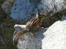
Posing |
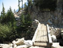
Bridge |
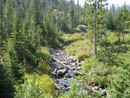
Creek |
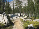
Slabs Along Trail |
Nice Reflection |
First Color |
Tarn Reflection |
More Color |
Photo Page 2
Trips - 2006
Home