3-04-07
Suzanne and I tried Higgins last winter. Soft unconsolidated
snow stopped us at the top of the boulder field well below the summit.
I was extended an invitation for a winter Higgins trip in a group where
I had only hiked with one other person. Kim and I picked up Carla and met
Janet, Mark, and Matt at the 128th St. Park and Ride at 7:00 AM. We were
on our way soon after. The area north of Seattle received from a few inches
to a foot of snow the past week. I was a little apprehensive about being
able to drive to the trailhead, even though it is at only 1350'. The snow
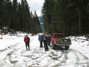
proved to not be a problem. There was one big log that had blocked the road
but has been removed. We found another fresh downed tree across the road.
It was not too big and three of us lifted it so the cars could pass. We reached
the trailhead at about 8:30.
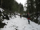
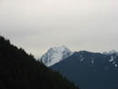
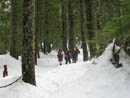
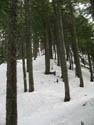
There was a little snow at the trailhead but also some bare ground. At 8:42 we headed out. The route used to start on a nice old road reverted to trail. Since a new round of logging a few years ago it now starts with a half mile or so of wide logging road. The road is moderately steep as we gained over 500' before real trail began. This trail is across on old clear cut. It is narrow and had some snow on it. We did now have views out to Whitehorse and Three Fingers. Once across the clear cut the trail enters forest.
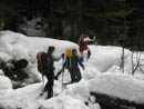
There are a number of trees down along here but most were easy enough to get over, under, or through. The boardwalks are mossy, rotting and very slippery in the summer. This day they were snow covered and easy to walk across. Soon we were dropping down for the always interesting crossing of Dick Creek. A little before the creek we stopped to put on snowshoes. With the shoes we rock hopped over one channel then over the other to the far side. No slips into the water by anyone.
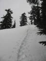
Once across the route begins a steady climb along side the creek. For the most part we stayed on the summer trail. The west ridge of Higgins soon took shape to our right. Our destination was the old Higgins lookout site. There is also a middle then farther east real summit of Higgins. Ours was the lowest but most accessible of the three summits. At 4849' it is about 3500' above the trailhead. We chose to climb directly up the ridge and run it to the summit instead of continuing up the valley on the route of the summer trail. The snow provided good solid steps and the climb to the ridge was fairly easy. Especially if you weren't the one breaking trail.
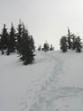
The ridge is heavily forested and has several good sized ups and downs. For the most part the snow was pretty well consolidated on the ridge. We climbed up then dropped over 100' to a saddle. There was only one spot that was reasonable to continue up the ridge. We climbed up aiming for this gap between two trees the would get us back on gentler terrain. Janet had her foot step give way as she was pulling herself up between the trees and I went down to lend a hand. The hand part worked well but my snowshoe slipped and I managed to hit her in the head with my shoe. Oops! Definitely not intentional. Everyone made it up that spot and we were back on the move.
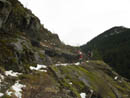
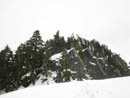
We continued a gentle climb and had another 100' descent. For the most part the ridge was easy walking. At one point I came upon a post hole that went way down in a gap between rocks. The ridge was very narrow here and I gingerly stepped around it. We did have one short view out but for the most part the forest was too thick. The map showed the ridge getting very steep near the summit and we expected to have to contour around to the north side. That's just what happened.
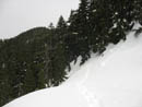
The traverse was across a very steep slope. If the snow was too hard or icy I would not have tried it. At least not without crampons. As it was the snow was soft but allowed fairly secure steps. It was too soft for an ice axe to do much but we did get them out for the crossing. After crossing below the summit we reached an mostly open slope on the north side. This is where the summer trail switchbacks up. We were able to walk directly up the slope. In short order we all topped out on the summit.
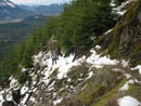
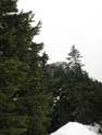
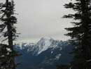
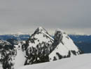
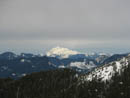
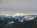
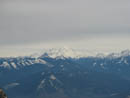
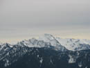
The forecast was for a high 6000' snow level and showers beginning in the afternoon. We had clouds but no rain at all. It was warm enough that Janet and I were in short sleeves much of the day. It was also windless except for shortly into our summit stay. It was cold when the wind blew. Mt. Baker was blocked by a peak but the Olympics were in the clear. Whitehorse had some sun shining on the north face and Three Fingers was clearly visible. Very nice views considering that the summit is under 5000'.
After at least half an hour on top we headed down. It took us nearly 4 1/2 hours to reach the top. We still had some 4 hours of daylight left as we descended. The immediate question was whether to retrace our track along the ridge top or descend the summer route to Myrtle Lake. We had a short discussion at the place where we traversed under the summit and the straight down route won. At first we were on a moderate ridge but as it steepened we chose to head straight down the fall line. It was very steep at first then became more gradual. The snow was about perfect for a steep descent as we sank in enough to grip firmly but not sink too far. With hardly a fall among us we reached gentle terrain.
The valley has a number of streams coming down from the ridge. The snow was 10+ feet deep along both side of many of them. We seemed to always be able to find a solid snow bridge to cross. We came to the big meadow and followed along the edge of it. The summer trail is on the opposite side. A larger creek came in on our right. We followed it through largely open forest meadows. When the terrain began to drop more steeply we had another discussion. To get to the lake we needed to be on the other side of the creek. It was a good 10 or more feet down to the bottom with vertical walls.
We retraced our steps back up the valley and found a spot where we were able to climb down a little and get across. A short time later we ran into Myrtle Lake. It's tough to get down to the shore in the summer but with all the brush buried by snow it was easy. We had a clear view all around the lake. We did find a number of trees near the shore with half the trunk cut out. Beavers? Hikers with no common sense? Either way those trees will likely not live much longer.
Now it was time to figure our way back down. We headed away from the lake on the left side of another deep creek trench. Dick Creek should be right ahead of us. In a few minutes we reached it. Getting across was not easy. We looked up and down and Matt found a reasonable spot. He tried to stomp steps down but ended up sliding to the bottom. There was a log across to an island. He took his shovel and dug away the snow to make for a reasonably angled descent. In the mean time Mark dropped down and crossed to the other side, kicking steps back up to the top of the trench. One by one, we made our way down, across, and back up.
A short climb away from the creek and we were back to good terrain for descending. We lost about 400' more and ran into our uphill tracks where we headed up to the ridge. Now it was just a downhill slog to our crossing of Dick Creek. The crossing proved to be no problem. The first four were sitting waiting and had too much time on their hands. They were busy making snowballs. A few came my way as I was crossing the creek. Since none of them knew me they quickly stopped. I would not have been mad but they did not know that.
Kim was the last to reach the creek. They all knew her. As she reached the middle of the creek the snowballs began to fly. At first they all missed then Janet began to zero in. Half a dozen direct hits later she made it across the creek. It was now after 5:00 PM and daylight was waning. A short way down the trail snowshoes came off and we booted it on out. Back out of the woods in the old clear cut we had a nice view of Whitehorse with the last of the day's sun. A lot of the snow along here had melting and the footing was better than I expected.
Once back on the road the last half mile went by quickly. I reached the cars at just about 6:00. It turned out to be a long day. We spent nearly 9 1/2 hours traveling a little over 8 miles. With ups and downs I would say there was about 3800' of gain. Our loop provided a variety of terrain, a nice summit, and a snow covered lake. The weather was a lot warmer than expected and the rain held off. I had a chance to hike with a group of new friends to a fun summit. Higgins is not an easy trip in the winter but it was well worthwhile.
More comments, reports, and photos here: Nwhikers Report .
Click on thumbnails to get larger pictures.
Photo Page 2
Trips - 2007
Home
There was a little snow at the trailhead but also some bare ground. At 8:42 we headed out. The route used to start on a nice old road reverted to trail. Since a new round of logging a few years ago it now starts with a half mile or so of wide logging road. The road is moderately steep as we gained over 500' before real trail began. This trail is across on old clear cut. It is narrow and had some snow on it. We did now have views out to Whitehorse and Three Fingers. Once across the clear cut the trail enters forest.
There are a number of trees down along here but most were easy enough to get over, under, or through. The boardwalks are mossy, rotting and very slippery in the summer. This day they were snow covered and easy to walk across. Soon we were dropping down for the always interesting crossing of Dick Creek. A little before the creek we stopped to put on snowshoes. With the shoes we rock hopped over one channel then over the other to the far side. No slips into the water by anyone.
Once across the route begins a steady climb along side the creek. For the most part we stayed on the summer trail. The west ridge of Higgins soon took shape to our right. Our destination was the old Higgins lookout site. There is also a middle then farther east real summit of Higgins. Ours was the lowest but most accessible of the three summits. At 4849' it is about 3500' above the trailhead. We chose to climb directly up the ridge and run it to the summit instead of continuing up the valley on the route of the summer trail. The snow provided good solid steps and the climb to the ridge was fairly easy. Especially if you weren't the one breaking trail.
The ridge is heavily forested and has several good sized ups and downs. For the most part the snow was pretty well consolidated on the ridge. We climbed up then dropped over 100' to a saddle. There was only one spot that was reasonable to continue up the ridge. We climbed up aiming for this gap between two trees the would get us back on gentler terrain. Janet had her foot step give way as she was pulling herself up between the trees and I went down to lend a hand. The hand part worked well but my snowshoe slipped and I managed to hit her in the head with my shoe. Oops! Definitely not intentional. Everyone made it up that spot and we were back on the move.
We continued a gentle climb and had another 100' descent. For the most part the ridge was easy walking. At one point I came upon a post hole that went way down in a gap between rocks. The ridge was very narrow here and I gingerly stepped around it. We did have one short view out but for the most part the forest was too thick. The map showed the ridge getting very steep near the summit and we expected to have to contour around to the north side. That's just what happened.
The traverse was across a very steep slope. If the snow was too hard or icy I would not have tried it. At least not without crampons. As it was the snow was soft but allowed fairly secure steps. It was too soft for an ice axe to do much but we did get them out for the crossing. After crossing below the summit we reached an mostly open slope on the north side. This is where the summer trail switchbacks up. We were able to walk directly up the slope. In short order we all topped out on the summit.
The forecast was for a high 6000' snow level and showers beginning in the afternoon. We had clouds but no rain at all. It was warm enough that Janet and I were in short sleeves much of the day. It was also windless except for shortly into our summit stay. It was cold when the wind blew. Mt. Baker was blocked by a peak but the Olympics were in the clear. Whitehorse had some sun shining on the north face and Three Fingers was clearly visible. Very nice views considering that the summit is under 5000'.
After at least half an hour on top we headed down. It took us nearly 4 1/2 hours to reach the top. We still had some 4 hours of daylight left as we descended. The immediate question was whether to retrace our track along the ridge top or descend the summer route to Myrtle Lake. We had a short discussion at the place where we traversed under the summit and the straight down route won. At first we were on a moderate ridge but as it steepened we chose to head straight down the fall line. It was very steep at first then became more gradual. The snow was about perfect for a steep descent as we sank in enough to grip firmly but not sink too far. With hardly a fall among us we reached gentle terrain.
The valley has a number of streams coming down from the ridge. The snow was 10+ feet deep along both side of many of them. We seemed to always be able to find a solid snow bridge to cross. We came to the big meadow and followed along the edge of it. The summer trail is on the opposite side. A larger creek came in on our right. We followed it through largely open forest meadows. When the terrain began to drop more steeply we had another discussion. To get to the lake we needed to be on the other side of the creek. It was a good 10 or more feet down to the bottom with vertical walls.
We retraced our steps back up the valley and found a spot where we were able to climb down a little and get across. A short time later we ran into Myrtle Lake. It's tough to get down to the shore in the summer but with all the brush buried by snow it was easy. We had a clear view all around the lake. We did find a number of trees near the shore with half the trunk cut out. Beavers? Hikers with no common sense? Either way those trees will likely not live much longer.
Now it was time to figure our way back down. We headed away from the lake on the left side of another deep creek trench. Dick Creek should be right ahead of us. In a few minutes we reached it. Getting across was not easy. We looked up and down and Matt found a reasonable spot. He tried to stomp steps down but ended up sliding to the bottom. There was a log across to an island. He took his shovel and dug away the snow to make for a reasonably angled descent. In the mean time Mark dropped down and crossed to the other side, kicking steps back up to the top of the trench. One by one, we made our way down, across, and back up.
A short climb away from the creek and we were back to good terrain for descending. We lost about 400' more and ran into our uphill tracks where we headed up to the ridge. Now it was just a downhill slog to our crossing of Dick Creek. The crossing proved to be no problem. The first four were sitting waiting and had too much time on their hands. They were busy making snowballs. A few came my way as I was crossing the creek. Since none of them knew me they quickly stopped. I would not have been mad but they did not know that.
Kim was the last to reach the creek. They all knew her. As she reached the middle of the creek the snowballs began to fly. At first they all missed then Janet began to zero in. Half a dozen direct hits later she made it across the creek. It was now after 5:00 PM and daylight was waning. A short way down the trail snowshoes came off and we booted it on out. Back out of the woods in the old clear cut we had a nice view of Whitehorse with the last of the day's sun. A lot of the snow along here had melting and the footing was better than I expected.
Once back on the road the last half mile went by quickly. I reached the cars at just about 6:00. It turned out to be a long day. We spent nearly 9 1/2 hours traveling a little over 8 miles. With ups and downs I would say there was about 3800' of gain. Our loop provided a variety of terrain, a nice summit, and a snow covered lake. The weather was a lot warmer than expected and the rain held off. I had a chance to hike with a group of new friends to a fun summit. Higgins is not an easy trip in the winter but it was well worthwhile.
More comments, reports, and photos here: Nwhikers Report .
Trailhead |
Road/Trail |
Crossing Clear Cut |
Kim On Trail |
Whitehorse Mountain |
Dick Creek |
Snowy Forest |
Encased In Snow |
Ridge Top |
Summit? |
Too Steep |
Traverse |
Whitehorse |
Turning Uphill |
Summit In Sight |
Higgins & Skadulgwas |
View North |
Shuksan |
Glacier Peak |
Three Fingers |
Photo Page 2
Trips - 2007
Home