12-15-07
Lots of snow was forecast and the avalanche danger
was rising. Where to go? We decided to visit an old favorite. The Nordic
Pass Trail is tucked in between ski areas. It is never steep and the avalanche
danger is very low. I have directions to find the start in this
trip report
. The first four photos of that report show where the route begins.
For this trip I was joined by Suzanne, Carla, Yumi, and David. There was
snow on the road the last ten miles to Snoqualmie Pass. We pulled off at
the Hyak exit and entered the Hyak (Summit East) parking lot. The Gold Creek
Sno-Park is the usual parking place but this day the ski area was not yet
open.
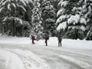
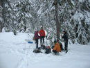
We met around 8:40 and were packed and on the trail at about 9:00 am. The road was very icy as we hiked on up. At the sharp left turn there was no snow bank built up yet. A very short walk brought us to the creek. This can be the crux of the trip there is a long drop down to the water. This day we were able to easily climb down and climb back up the far side. Once there, we put on our snowshoes.
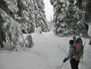
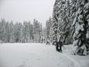
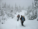
There is a "Nordic Pass Trail" sign just across the creek. The route goes away from the creek but there is still brush poking through the snow cover. WE angled to our left then dropped back down and found a blue diamond. There were no tracks at all in the snow. It snowed 5 inches the day before and another 5 inches over night. The trees were heavily flocked with snow.
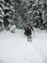
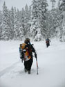
It was a challenge to stay on route but for the most part we were able to find a diamond each time we were unsure. The snow was deep enough to slow us down but not so deep that cutting trail was overly difficult. When we crossed the first crossover road it was so snow covered that I did not notice it. We switchbacked uphill at the gentle grade of the route. We reached the "Intermountain 90" crossover road and it was completely ungroomed. We hit the road well to the left of where the trail reaches it. A traverse to our right then back uphill took us to the big meadow. From there it's not far to Hyak Lake.
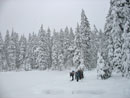
At the end of the lake the Atlas Trail signs were evident. We had to look a little to find the next blue diamond. We soon reached the next crossover road. It had been groomed but was covered with fresh snow. The route leaves deep forest and in the smaller trees it was hard to stay on route. We took the path of least resistance through the trees and found another diamond before we reached the power line corridor.
We popped out on another road. This is the groomed nordic ski area. A groomer came by as we were looking at a nordic trails map. A little road walking and we found a diamond heading back into the forest. We had a little trouble beyond this where downed trees made travel harder. They will easier to pass with another five feet of snow. We passed Frog Lake and continued on. The snow was coming down even harder now. We were all covered in white.
A final climb brought us to Nordic Pass. It was now 1:00 pm. Any thought of continuing on to Mt. Catherine was dropped. It took us four hours just to hike the 3 1/2 miles to the pass. The Noric Pass sign way above us. It was amazing to see how low the snow depth was. It was windy and very cold as we ate a late lunch. I was soon ready to get moving in an effort to warm up. We made good time back to Frog Lake and then back to the ski road. The trail paralleled the road here and we chose to pop out onto the road. Maybe not such a good idea.
Soon the road turned to our left. We didn't want to retrace our steps to we continued in the wrong direction. Another road turned off to the right. We took it. Another road turned off to the right. We took that. We crossed under the power lines once then back again. David's GPS confirmed that we were getting closer to our track heading in. A lot of searching turned up our route. Our tracks were covered by a few inches of fresh snow.
Now on track we head back into forest and down to the upper crossover road. Here we saw a couple of folks running on the groomed road. Huh? They turned out to be the only people we saw all day. We passed Hyak Lake and dropped back to Intermounatan 90. Here we had one more decision to make. Follow our tracks down the road and through the forest or cross over and follow the blue diamonds down to where we lost the route on the way up. Follow our trench or make a new one. We chose to break more trail.
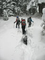
We expected to reach our uphill track pretty quickly. That did not happen. We kept heading downhill in deep snow. At one point Suzanne fell through and her snowshoe was trapped by a buried branch. It took a lot of digging to get her out. We finally found a trench and followed it down. Unfortunately it was not ours. That became clear when we reached a bridge over Hyak Creek. Darn! We headed back uphill and soon found our uphill track. It was hard to find under fresh snow.
Now we did not have much farther to go. The last part went quickly. It was a good thing. With our two "short cuts" we took more time coming down than expected. In fact we reached the cars right at sunset, about 4:15. It was a long day to do a fairly short hike. The flocked trees were very pretty. The solitude was a little unexpecteed. The company was first rate. It was my first snowshoe trip of the season and it was a whole lot of fun.
Click on thumbnails to get larger pictures.
Trips - 2007
Home
We met around 8:40 and were packed and on the trail at about 9:00 am. The road was very icy as we hiked on up. At the sharp left turn there was no snow bank built up yet. A very short walk brought us to the creek. This can be the crux of the trip there is a long drop down to the water. This day we were able to easily climb down and climb back up the far side. Once there, we put on our snowshoes.
There is a "Nordic Pass Trail" sign just across the creek. The route goes away from the creek but there is still brush poking through the snow cover. WE angled to our left then dropped back down and found a blue diamond. There were no tracks at all in the snow. It snowed 5 inches the day before and another 5 inches over night. The trees were heavily flocked with snow.
It was a challenge to stay on route but for the most part we were able to find a diamond each time we were unsure. The snow was deep enough to slow us down but not so deep that cutting trail was overly difficult. When we crossed the first crossover road it was so snow covered that I did not notice it. We switchbacked uphill at the gentle grade of the route. We reached the "Intermountain 90" crossover road and it was completely ungroomed. We hit the road well to the left of where the trail reaches it. A traverse to our right then back uphill took us to the big meadow. From there it's not far to Hyak Lake.
At the end of the lake the Atlas Trail signs were evident. We had to look a little to find the next blue diamond. We soon reached the next crossover road. It had been groomed but was covered with fresh snow. The route leaves deep forest and in the smaller trees it was hard to stay on route. We took the path of least resistance through the trees and found another diamond before we reached the power line corridor.
We popped out on another road. This is the groomed nordic ski area. A groomer came by as we were looking at a nordic trails map. A little road walking and we found a diamond heading back into the forest. We had a little trouble beyond this where downed trees made travel harder. They will easier to pass with another five feet of snow. We passed Frog Lake and continued on. The snow was coming down even harder now. We were all covered in white.
A final climb brought us to Nordic Pass. It was now 1:00 pm. Any thought of continuing on to Mt. Catherine was dropped. It took us four hours just to hike the 3 1/2 miles to the pass. The Noric Pass sign way above us. It was amazing to see how low the snow depth was. It was windy and very cold as we ate a late lunch. I was soon ready to get moving in an effort to warm up. We made good time back to Frog Lake and then back to the ski road. The trail paralleled the road here and we chose to pop out onto the road. Maybe not such a good idea.
Soon the road turned to our left. We didn't want to retrace our steps to we continued in the wrong direction. Another road turned off to the right. We took it. Another road turned off to the right. We took that. We crossed under the power lines once then back again. David's GPS confirmed that we were getting closer to our track heading in. A lot of searching turned up our route. Our tracks were covered by a few inches of fresh snow.
Now on track we head back into forest and down to the upper crossover road. Here we saw a couple of folks running on the groomed road. Huh? They turned out to be the only people we saw all day. We passed Hyak Lake and dropped back to Intermounatan 90. Here we had one more decision to make. Follow our tracks down the road and through the forest or cross over and follow the blue diamonds down to where we lost the route on the way up. Follow our trench or make a new one. We chose to break more trail.
We expected to reach our uphill track pretty quickly. That did not happen. We kept heading downhill in deep snow. At one point Suzanne fell through and her snowshoe was trapped by a buried branch. It took a lot of digging to get her out. We finally found a trench and followed it down. Unfortunately it was not ours. That became clear when we reached a bridge over Hyak Creek. Darn! We headed back uphill and soon found our uphill track. It was hard to find under fresh snow.
Now we did not have much farther to go. The last part went quickly. It was a good thing. With our two "short cuts" we took more time coming down than expected. In fact we reached the cars right at sunset, about 4:15. It was a long day to do a fairly short hike. The flocked trees were very pretty. The solitude was a little unexpecteed. The company was first rate. It was my first snowshoe trip of the season and it was a whole lot of fun.
Trailhead |
Untracked Snow |
Cutting A Trench |
Forest Opening |
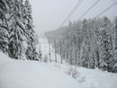
Intermountain 90 |
Meadow |
Deeper |
Hyak Lake |
Ungroomed Road |
Nordic Pass |
Trips - 2007
Home