9-8-07
Last week Kim and I hiked bushwhacked through 41 miles
on Meadow Mountain
. This week we decided to do a little easier hike. Initially we were
set on Trappers Peak but at the last minute we changed that to Park Butte
Lookout. That was probably a good idea. I have been to the lookout three
times. The last time was twelve years ago. We had a reasonably late start
at 7:00 am. We were on the trail by 9:30. The parking lot was much
different than I remembered it. On my last visit the Scott Paul Trail
had only been open for a few years. I had been meaning to come back and
hike it some day. Today was that day.
The turnoff for the Scott Paul Trail is only some 50' from the start. It heads off just before the bridge over the creek. We decided we were up for a bit more than just the 7 miles up and back via the Park Butte Trail. We would go up the Scott Paul and down Park Butte. The Scott Paul meets the Park Butte after 5 1/2 miles at the 2 mile mark on the Park Butte.
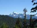
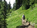
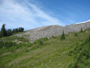
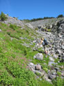
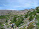
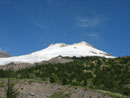
The Scott Paul Trail is gently graded and well maintained. We climbed slowly and came out of the forest and into a nice small meadow. From here we had our first views of Mt. Baker and Mt. Shuksan. The view of Baker is unlike anything I have seen. We returned to forest for awhile. The trail breaks back out of the forest into high parkland. It now heads towards Railroad Grade and Park Butte.
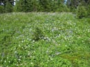
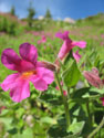
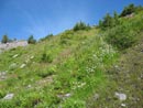
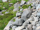
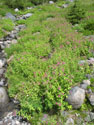
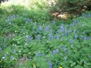
Numerous creeks are crossed. This time of year only a few still had water. Those were easy to rock hop across. Earlier in the year those creeks could be quite an impediment. Where there was water a surprising number of flowers were still in bloom. Monkeyflower was especially abundant. Even lupine was blooming. Each time we would leave a basin another one would present itself. I lost count of all the basins we passed through.
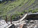
After reaching the high point we began to descend. I was sure I had read about a suspension bridge on the trail but we seemed to be getting very close to the Railroad Grade and still no bridge. We dropped down into the Railroad Grade moraine. It turned out to have two channels. After climbing over one and into the other we saw the bridge ahead. It has no tall towers and is not all that long. The creek underneath is flowing chocolate brown. The bridge moves just enough to make it interesting.
Once acorss we traversed the side of the moraine and soon reached the intesection with the other trail coming from the trailhead. From here it is about 1 1/2 miles with 800' of gain to the lookout. Much trail work has been done. Sections of old trail that were little more than a ditch have been moved slightly to drier ground. We began to meet groups heading down. We hoped the lookout would not be crammed with visitors.
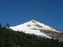
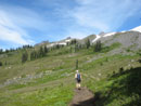
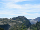
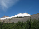
The trail up Park Butte is not too steep. From Morovitz Meadow we had continuous views up to Mt. Baker. This location is both very close and yet far enough away to be able to take in the whole mountain. We continued our liesurely climb with lots of photo stops. Eventually we reached the lookout. It is maintained by the Skagit Alpine Club. In fact they have been repainting it. Still some fresh paint smell. It was pleasantly warm and the sky was mostly blue. This is definitely one of the premier places for volcano viewing.
The guest registers are saved and we skimmed through volumes dating back 30 years. I'm sure I have previous comments in there somewhere. The mountains were nearly cloud free. Great views over to Shuksan, Hagan, and Blum. Whiteshorse and Three Fingers are to the south. Glacier Peak is easy to pick out. It's an unusual angle and I could not recognize many of the peaks.
We met Silence from nwhikers.net in the lookout. It's a small world for local hikers. Several large groups left as we were arriving and we had the lookout to ourselves for a short while. It was not crowded at all. All to soon we had to head down. The entire route down is gentle. No knee banging this day. We were soon back at the Scott Paul junction with just two miles to go.
I knew that crossing Rocky Creek can be an adventure on a warm day when the afternoon melt raises the water level. Since we came up the other trail we had no idea what the crossing was like. That's some of the fun of a loop. I remember a short rocky section with a wide shallow creek to reck hop. That was twelve years ago. I knew that the 2003 floods had changed things. Boy did it!
We reached rocks while still in the trees. The rock crossing went quite a ways before we reached water. The creek must have been 20 times wider during the flood. The creek itself was dark brown, fast flowing, and deeper than I was expecting. I could see no tress across downstream. There was a tree most of the way across just upstream with a smaller log going the rest of the way. I went up to explore. Another hiker was at the stream and mentioned how much higher the wate was than when he had crossed earlier.
I butt slid across the first log and gingerly stepped over the other. The other hiker and Kim followed me. A little hairy but not too bad. Much better than trying to ford when you can't see the bottom of the creek. We were passed by a few groups heading down who mentioned "planks". It seems there are wooden planks to cross on. I guess they were at or under the water level and I could not see them when I looked downstream. That is the disadvantage of not having come in that way.
Soon after crossing the creek we came to an equally wide rocky creek bed. This is there a bridge used to be. The creek no longer flows here. We found a cement bridge abutment and a number of pieces of the old bridge. There is not much left. So the flooding creek was not only 20 times the size of it's current bed but filled another bed just as large. Wow!
The rest of the descent went fast. We did find many ripe berries in Schreiber's Meadow. The berries up high were blue but tart. Down low they were very sweet. It was around 6:00 pm by the time we reached the trailhead. It was a long and very enjoyable day. Depending which description you believe, we hiked 11 1/2 to 12 miles with about 2900' of gain. A nice but not overly strenuous day.
On the way home we checked out a recent recommendation. Just west of where the Gandy - Baker Lake Road reaches Highway 20 is the Birdsview Brewing Company. It's fairly new. The menu is still pretty basic but the burger was excellent. They have more than half a dozen inhouses brews. The Witless and Ditzy Blonde were very good. The dining area has no age limit and there is a kid's menu as well. Well worth a visit if you are in the area.
I will have photos up soon (I hope). In the meantime Kim has a report with photos posted at nwhikers.net.
Click on thumbnails to get larger pictures.
Photo Page 2
Trips - 2007
Home
The turnoff for the Scott Paul Trail is only some 50' from the start. It heads off just before the bridge over the creek. We decided we were up for a bit more than just the 7 miles up and back via the Park Butte Trail. We would go up the Scott Paul and down Park Butte. The Scott Paul meets the Park Butte after 5 1/2 miles at the 2 mile mark on the Park Butte.
The Scott Paul Trail is gently graded and well maintained. We climbed slowly and came out of the forest and into a nice small meadow. From here we had our first views of Mt. Baker and Mt. Shuksan. The view of Baker is unlike anything I have seen. We returned to forest for awhile. The trail breaks back out of the forest into high parkland. It now heads towards Railroad Grade and Park Butte.
Numerous creeks are crossed. This time of year only a few still had water. Those were easy to rock hop across. Earlier in the year those creeks could be quite an impediment. Where there was water a surprising number of flowers were still in bloom. Monkeyflower was especially abundant. Even lupine was blooming. Each time we would leave a basin another one would present itself. I lost count of all the basins we passed through.
After reaching the high point we began to descend. I was sure I had read about a suspension bridge on the trail but we seemed to be getting very close to the Railroad Grade and still no bridge. We dropped down into the Railroad Grade moraine. It turned out to have two channels. After climbing over one and into the other we saw the bridge ahead. It has no tall towers and is not all that long. The creek underneath is flowing chocolate brown. The bridge moves just enough to make it interesting.
Once acorss we traversed the side of the moraine and soon reached the intesection with the other trail coming from the trailhead. From here it is about 1 1/2 miles with 800' of gain to the lookout. Much trail work has been done. Sections of old trail that were little more than a ditch have been moved slightly to drier ground. We began to meet groups heading down. We hoped the lookout would not be crammed with visitors.
The trail up Park Butte is not too steep. From Morovitz Meadow we had continuous views up to Mt. Baker. This location is both very close and yet far enough away to be able to take in the whole mountain. We continued our liesurely climb with lots of photo stops. Eventually we reached the lookout. It is maintained by the Skagit Alpine Club. In fact they have been repainting it. Still some fresh paint smell. It was pleasantly warm and the sky was mostly blue. This is definitely one of the premier places for volcano viewing.
The guest registers are saved and we skimmed through volumes dating back 30 years. I'm sure I have previous comments in there somewhere. The mountains were nearly cloud free. Great views over to Shuksan, Hagan, and Blum. Whiteshorse and Three Fingers are to the south. Glacier Peak is easy to pick out. It's an unusual angle and I could not recognize many of the peaks.
We met Silence from nwhikers.net in the lookout. It's a small world for local hikers. Several large groups left as we were arriving and we had the lookout to ourselves for a short while. It was not crowded at all. All to soon we had to head down. The entire route down is gentle. No knee banging this day. We were soon back at the Scott Paul junction with just two miles to go.
I knew that crossing Rocky Creek can be an adventure on a warm day when the afternoon melt raises the water level. Since we came up the other trail we had no idea what the crossing was like. That's some of the fun of a loop. I remember a short rocky section with a wide shallow creek to reck hop. That was twelve years ago. I knew that the 2003 floods had changed things. Boy did it!
We reached rocks while still in the trees. The rock crossing went quite a ways before we reached water. The creek must have been 20 times wider during the flood. The creek itself was dark brown, fast flowing, and deeper than I was expecting. I could see no tress across downstream. There was a tree most of the way across just upstream with a smaller log going the rest of the way. I went up to explore. Another hiker was at the stream and mentioned how much higher the wate was than when he had crossed earlier.
I butt slid across the first log and gingerly stepped over the other. The other hiker and Kim followed me. A little hairy but not too bad. Much better than trying to ford when you can't see the bottom of the creek. We were passed by a few groups heading down who mentioned "planks". It seems there are wooden planks to cross on. I guess they were at or under the water level and I could not see them when I looked downstream. That is the disadvantage of not having come in that way.
Soon after crossing the creek we came to an equally wide rocky creek bed. This is there a bridge used to be. The creek no longer flows here. We found a cement bridge abutment and a number of pieces of the old bridge. There is not much left. So the flooding creek was not only 20 times the size of it's current bed but filled another bed just as large. Wow!
The rest of the descent went fast. We did find many ripe berries in Schreiber's Meadow. The berries up high were blue but tart. Down low they were very sweet. It was around 6:00 pm by the time we reached the trailhead. It was a long and very enjoyable day. Depending which description you believe, we hiked 11 1/2 to 12 miles with about 2900' of gain. A nice but not overly strenuous day.
On the way home we checked out a recent recommendation. Just west of where the Gandy - Baker Lake Road reaches Highway 20 is the Birdsview Brewing Company. It's fairly new. The menu is still pretty basic but the burger was excellent. They have more than half a dozen inhouses brews. The Witless and Ditzy Blonde were very good. The dining area has no age limit and there is a kid's menu as well. Well worth a visit if you are in the area.
I will have photos up soon (I hope). In the meantime Kim has a report with photos posted at nwhikers.net.
Mt. Shuksan |
Baker From Scott Paul |
Grassy Slope |
Lots Of Flowers |
Just Below Moraine |
Monkey Flower |

More Monkey Flower |
Creek & Flowers |
Late Season Blooms |
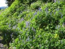
Lupine |
Poser |
Big Meadows |
Park Butte |
Even More Monkey |
Railroad Grade |

Another Creek |
Volcano Above |
Suspension Bridge |
10,778' |
More Lupine |
Photo Page 2
Trips - 2007
Home