Page 2
Day Two
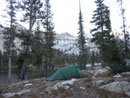
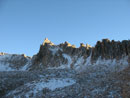
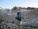
It was well below freezing overnight. The ground was frozen all around our tent. Inside the tent it stayed above freezing. The plan for this day was to cross Snowyside Pass, drop to Toxaway Lake, climb to Toxaway Divide, drip to Edna and Virginia Lakes, then climb to Hidden Lake. It would be a long day with two climbs to over 9200'. All my maps and books show a trail heading straight to Twin Lakes then rapidly ascending to Snowyside Pass. That's now how it goes now.
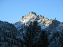
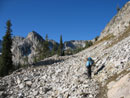
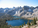
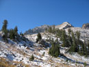
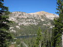
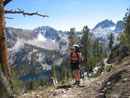
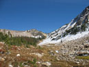
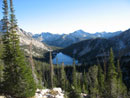
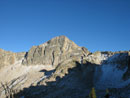
From Alice Lake the trail begins a long gentle climb. Fresh snow on the peaks really made them stand out. The new trail reaches a junction with a side trail down to Twin Lakes. It traverses to the right around a tarn and switchbacks up the slope. Snowyside Peak came into view. The pass is at 9390'. It is little more than a defile blasted out of the ridge.
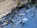
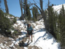
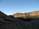
We climbed left of the pass to better views down to Twin Lakes on one side, Snowyside Peak above, and several tarns on the Toxaway side. There was enough thin slick snow on Snowyside that a scramble did not look like much fun. We did not have enough time anyway. The Alice Lake side had no snow high near the pass. The other side did have snow. We saw what looked like foot steps in the snow at the pass. There were none going down.
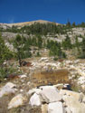
We crunched through up to 3 inches of snow on the way down. It was warming rapidly and we were plenty warm enough hiking down. By the time we reached the first tarn we were heading back into the trees. The steep granite walls of the basin shone in the sunlight as they had a thin layer of snow. The trail drops down to the shore of the second tarn. After that we traveled through thin forest and granite outcroppings. Trees grew out from cracks in the rock.
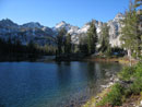
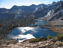
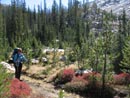
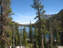
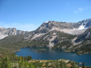
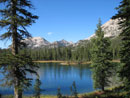
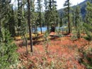
Lower down Toxaway Lake came into view. The trail then crossed over the outlet creek of the tarns. At the crossing the creek was flowing over granite slabs with small waterfalls between them. The trail levels off a few hundred feet above Toxaway Lake. We crossed meadows with a little fall color and stopped at some granite slabs with views down to the lake. It made for a very nice lunch spot.
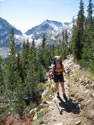
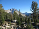
After lunch we hiked in forest along the side of the lake. Where the forest opens we reached a junction. Straight ahead would loop back to Pettit Lake. We took the uphill trail on the left. The two mile segment climbs to 9280' Toxaway Divide. It gains 957' at a very gentle grade. It was getting warmer and we stripped down to shorts and short sleeves. It was likely in the low 60s with little breeze. Very comfortable. It was a good thing as there is very little shade on the climb.
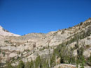
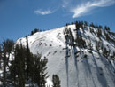
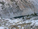
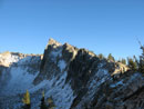
As always in this area the passes are not where you think they will be. We climbed to below an obvious pass and then contoured around a small peak to the real pass. Last year I scrambled up steep loose rock a few hundred feet to the top for better views. This year we were surprised to see the bare south side give way to a completely snow covered north side. The thin wet snow did not look like much fun to scramble up. A slip would provide a wild slide to the valley below.
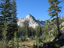
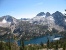
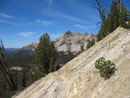
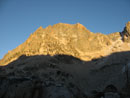
On the positive side, the smoky views of the previous year were replaced by crystal clear views of Cramer and Payette Peaks with a dusting of snow for highlighting. Very nice views. From near Toxaway Divide we could see back to Snowyside Pass. From the pass a gully drops sharply down to the basin below. On the left side of the gully the whole hillside was snow covered. The trail is on the right side and it was mostly snow free.
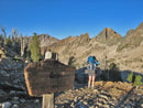
Many more very gentle switchbacks brought us down to the floor of the basin. There is a large tarn that the trail does not pass very close to. At this lower elevation the trail was shaded by trees and we still had large patches of snow. It was bare enough to allow us to keep on route. The trail sign says it's 2 1/2 miles from the divide to Edna Lake. It seemed much shorter. The trail goes along the shore and we used this opportunity to filter more water.
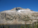
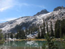
Edna is at 8404'. The trail descends a short way to Virginia Lake. Meadows along the lake proved the best fall colors of the hike. The sun back lit the reds setting them ablaze. We soon reached the low point of the day where the trail crosses the headwaters of the Payette River near 8200'. Now began a gentle climb to Hidden Lake. I'm used to climbing in the morning and descending in the afternoon. All these climbs and descents were a little different.
Hiking so long above 8000' was also a little different for us sea level hikers. The plan was to stop at Hidden Lake. It was near 4:45 when we arrived. We decided to look at our options. We wanted to hike up to Alpine Lake the next day. The day after that the weather was forecast to take a turn for the worse. If we were to get up to Baron Divide and down to Baron Lakes it would be hard starting from Hidden Lake. Now if we could cross Cramer Divide and drop to Cramer Lakes the following day would be more successful.
What I did not want to do was to get up to the Divide, find lots of snow, and loose the route in the barren moraine below. At 9480' Cramer Divide would be the high point of our trip. The route also is completely shaded near the top on the north side and would hold more snow. We had no ice axes and only lightweight boots. With a little trepidation we chose to head higher.
It was now at 5:30 pm. Hidden Lake is at 8563'. The 900' climb to the divide is over 1 1/2 miles. The good news is that it was dark in Seattle at 7:00 pm but not here until 8:00 pm. We had a very nice look down to the lake and up to Payette Peak. For the second year in a row the afternoon lighting was harsh and my photos did not turn out well.
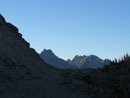
As we neared Cramer Divide we said goodbye to the sunshine. It would be shade for the rest of the day. The sign at the divide says that it is 2.3 miles down to Upper Cramer Lake. It felt like more. It was now about 6:30 so we still had about an hour and a half of light. To my surprise and pleasure the snow cover on the upper trail below the pass was not deep enough to cover the route.
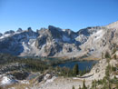
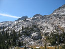
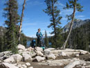
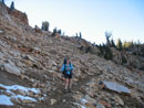
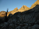
The peaks surrounding the upper basin were still dusted with fresh snow and appeared quite beautiful. I almost reached the summit of the Temple last year but a lack of time would not allow another try. After taking a number of photos we plunged down through the crunchy snow. Absolutely nothing but a few wisps of grass grow in the moraine. That made it more surprising to hear all the yelps of many pikas. Hard to believe there is enough food to support the population.
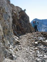
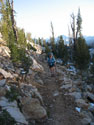
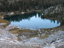
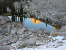
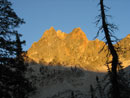
The "trail" has been blasted in many places as the moraine is just an enormous sloping field of boulders. As the sun set some ot the ridge ringing the basin turned a blazing red color. We were in a hurry but there was so much to photograph that it did slow us down. The rock eventually gave way to a large tarn on the left and a smaller one on the right. We dropped into open forest which made it darker.
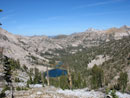
Darkness was rapidly setting in as we had our first view of Upper Cramer Lake. More downhill brought us to the meadows near the inlet. We cut across the meadow to the shore and followed it to the campsite I had used last year. It was still barely light as we arrived. The site was fine for a solo tent but not flat and root free enough for the Nallo. Uh oh... We quickly decided to head down to the end of the lake where there are more campsites.
We arrived at dark and ran around looking for a site. We found one good enough under the circumstances and put up the tent. I went off by headlamp to hang a food line. After a long search I found a suitable tree. At 8381' the trees are tall but with very short downward sloping branches. I dumped out the line only to find it tangled up beyond belief. The more I pulled at it the worse it became. Suzanne must have wondered what was going on. A loss of my sanity is what was going on.
After much cursing and pulling I got it untangled. One throw and it was over the branch. By now Suzanne had lit the stove, boiled the water, and our dehydrated dinners were ready to eat. Yeah, it took me a long time to hang the food line. By the time we were ready to climb into the tent it was 9:15. We were on the trail at 9:30 am. That was one long day. We did manage to cross three passes at 9280' or more while hiking 16 miles with 3200' of gain. All with full backpacks. It was a long day but it set us up nicely for day three.
Click on thumbnails to get larger pictures.
<< Report & Photo Page >>
Sawtooth Mountains Report
Home
It was well below freezing overnight. The ground was frozen all around our tent. Inside the tent it stayed above freezing. The plan for this day was to cross Snowyside Pass, drop to Toxaway Lake, climb to Toxaway Divide, drip to Edna and Virginia Lakes, then climb to Hidden Lake. It would be a long day with two climbs to over 9200'. All my maps and books show a trail heading straight to Twin Lakes then rapidly ascending to Snowyside Pass. That's now how it goes now.
From Alice Lake the trail begins a long gentle climb. Fresh snow on the peaks really made them stand out. The new trail reaches a junction with a side trail down to Twin Lakes. It traverses to the right around a tarn and switchbacks up the slope. Snowyside Peak came into view. The pass is at 9390'. It is little more than a defile blasted out of the ridge.
We climbed left of the pass to better views down to Twin Lakes on one side, Snowyside Peak above, and several tarns on the Toxaway side. There was enough thin slick snow on Snowyside that a scramble did not look like much fun. We did not have enough time anyway. The Alice Lake side had no snow high near the pass. The other side did have snow. We saw what looked like foot steps in the snow at the pass. There were none going down.
We crunched through up to 3 inches of snow on the way down. It was warming rapidly and we were plenty warm enough hiking down. By the time we reached the first tarn we were heading back into the trees. The steep granite walls of the basin shone in the sunlight as they had a thin layer of snow. The trail drops down to the shore of the second tarn. After that we traveled through thin forest and granite outcroppings. Trees grew out from cracks in the rock.
Lower down Toxaway Lake came into view. The trail then crossed over the outlet creek of the tarns. At the crossing the creek was flowing over granite slabs with small waterfalls between them. The trail levels off a few hundred feet above Toxaway Lake. We crossed meadows with a little fall color and stopped at some granite slabs with views down to the lake. It made for a very nice lunch spot.
After lunch we hiked in forest along the side of the lake. Where the forest opens we reached a junction. Straight ahead would loop back to Pettit Lake. We took the uphill trail on the left. The two mile segment climbs to 9280' Toxaway Divide. It gains 957' at a very gentle grade. It was getting warmer and we stripped down to shorts and short sleeves. It was likely in the low 60s with little breeze. Very comfortable. It was a good thing as there is very little shade on the climb.
As always in this area the passes are not where you think they will be. We climbed to below an obvious pass and then contoured around a small peak to the real pass. Last year I scrambled up steep loose rock a few hundred feet to the top for better views. This year we were surprised to see the bare south side give way to a completely snow covered north side. The thin wet snow did not look like much fun to scramble up. A slip would provide a wild slide to the valley below.
On the positive side, the smoky views of the previous year were replaced by crystal clear views of Cramer and Payette Peaks with a dusting of snow for highlighting. Very nice views. From near Toxaway Divide we could see back to Snowyside Pass. From the pass a gully drops sharply down to the basin below. On the left side of the gully the whole hillside was snow covered. The trail is on the right side and it was mostly snow free.
Many more very gentle switchbacks brought us down to the floor of the basin. There is a large tarn that the trail does not pass very close to. At this lower elevation the trail was shaded by trees and we still had large patches of snow. It was bare enough to allow us to keep on route. The trail sign says it's 2 1/2 miles from the divide to Edna Lake. It seemed much shorter. The trail goes along the shore and we used this opportunity to filter more water.
Edna is at 8404'. The trail descends a short way to Virginia Lake. Meadows along the lake proved the best fall colors of the hike. The sun back lit the reds setting them ablaze. We soon reached the low point of the day where the trail crosses the headwaters of the Payette River near 8200'. Now began a gentle climb to Hidden Lake. I'm used to climbing in the morning and descending in the afternoon. All these climbs and descents were a little different.
Hiking so long above 8000' was also a little different for us sea level hikers. The plan was to stop at Hidden Lake. It was near 4:45 when we arrived. We decided to look at our options. We wanted to hike up to Alpine Lake the next day. The day after that the weather was forecast to take a turn for the worse. If we were to get up to Baron Divide and down to Baron Lakes it would be hard starting from Hidden Lake. Now if we could cross Cramer Divide and drop to Cramer Lakes the following day would be more successful.
What I did not want to do was to get up to the Divide, find lots of snow, and loose the route in the barren moraine below. At 9480' Cramer Divide would be the high point of our trip. The route also is completely shaded near the top on the north side and would hold more snow. We had no ice axes and only lightweight boots. With a little trepidation we chose to head higher.
It was now at 5:30 pm. Hidden Lake is at 8563'. The 900' climb to the divide is over 1 1/2 miles. The good news is that it was dark in Seattle at 7:00 pm but not here until 8:00 pm. We had a very nice look down to the lake and up to Payette Peak. For the second year in a row the afternoon lighting was harsh and my photos did not turn out well.
As we neared Cramer Divide we said goodbye to the sunshine. It would be shade for the rest of the day. The sign at the divide says that it is 2.3 miles down to Upper Cramer Lake. It felt like more. It was now about 6:30 so we still had about an hour and a half of light. To my surprise and pleasure the snow cover on the upper trail below the pass was not deep enough to cover the route.
The peaks surrounding the upper basin were still dusted with fresh snow and appeared quite beautiful. I almost reached the summit of the Temple last year but a lack of time would not allow another try. After taking a number of photos we plunged down through the crunchy snow. Absolutely nothing but a few wisps of grass grow in the moraine. That made it more surprising to hear all the yelps of many pikas. Hard to believe there is enough food to support the population.
The "trail" has been blasted in many places as the moraine is just an enormous sloping field of boulders. As the sun set some ot the ridge ringing the basin turned a blazing red color. We were in a hurry but there was so much to photograph that it did slow us down. The rock eventually gave way to a large tarn on the left and a smaller one on the right. We dropped into open forest which made it darker.
Darkness was rapidly setting in as we had our first view of Upper Cramer Lake. More downhill brought us to the meadows near the inlet. We cut across the meadow to the shore and followed it to the campsite I had used last year. It was still barely light as we arrived. The site was fine for a solo tent but not flat and root free enough for the Nallo. Uh oh... We quickly decided to head down to the end of the lake where there are more campsites.
We arrived at dark and ran around looking for a site. We found one good enough under the circumstances and put up the tent. I went off by headlamp to hang a food line. After a long search I found a suitable tree. At 8381' the trees are tall but with very short downward sloping branches. I dumped out the line only to find it tangled up beyond belief. The more I pulled at it the worse it became. Suzanne must have wondered what was going on. A loss of my sanity is what was going on.
After much cursing and pulling I got it untangled. One throw and it was over the branch. By now Suzanne had lit the stove, boiled the water, and our dehydrated dinners were ready to eat. Yeah, it took me a long time to hang the food line. By the time we were ready to climb into the tent it was 9:15. We were on the trail at 9:30 am. That was one long day. We did manage to cross three passes at 9280' or more while hiking 16 miles with 3200' of gain. All with full backpacks. It was a long day but it set us up nicely for day three.
Cold Morning |
First Light |
Light On Lake |
Peak Through Trees |
Talus Slope |
Snowyside Pass |
Snowyside Peak |
A Twin Lake |
Both Lakes |
Suzanne At Pass |
Sparkling Lakes |
North Of Pass |
Snow Near Pass |
Back To Near Pass |
First Tarn |
Granite |
Nearing Toxaway |
Meadow Color |
Toxaway Lake |
Lunch Tiime |
Junction |
Toxaway Below |
Near Divide |
Lake & Pass |
Toxaway Divide |
North Side Snow |
Lots Of Snow |
Bare To The Right |
Looking At Divide |
Virginia Lake |
Nice Color |

Hidden Lake |
Payette Peak |
Lake In Shade |
Barren Tarn |
Dark Near Divide |
Almost To Divide |
Cramer Peak? |
The Temple |
Cramer Divide |
Below Divide |
Sun On Temple |
Reddish |
Larger Tarn |
Tarn Reflection |
Suzanne In Moraine |
Nice Contrast |
Dark & Light |
Lit Up |
Cramer Reflection |
<< Report & Photo Page >>
Sawtooth Mountains Report
Home