5/25-27/07
In an earlier report I said that a day hike with Kim
was never dull. Well, a 4 1/2 day hiking, camping, backpacking trip covering
over 700 miles is even more interesting. We headed out of town at 1:00
pm on Thursday, well ahead of the Memorial Day weekend crowds. Our route
took us over Highway 20 in the North Cascades. Hard to believe, but I had
never been farther than Rainy Pass. There were a number of other firsts
on this trip to north central Washington. We followed a moderate pace with
a number of stops along the way. It was near 9:00 pm when we cruised into
Republic. From there we took Highway 21 south about 10 miles to the Ten
Mile Creek campgrounds.
There was one other vehicle in the campgrounds. It was now almost completely dark as we set out to round up some wood for a fire. We piled up some thin branches and some paper to get the fire going. The wood was so dry it fired right up. Dinner consisted of salmon, potatoes, corn on the cob, and carrots in aluminum foil thrown into the fire. As the flames settled down we added grilled steak. Amazingly, it all turned out great. Everything done to perfection. Who would think that Kim is also a gourmet cook with a campfire.
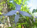
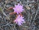
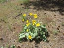
By the time we headed to bed it was already near 11:30. In the morning we repacked our backpacks and drove three miles south to the Thirteen Mile Creek trailhead and campgrounds. We were, not surprisingly, the only car in the lot. The trail begins climbing immediately as it ascends along the creek in a narrow gorge. Flowers began with our first steps and never ended for the whole trip. Our route was mostly in forest with a mix of forest and desert flowers. Flowering strawberries were seen on the entire route. Paintbrush and violets gave way to bitterroot and onions. We saw calypso orchids, columbia clematis, scarlet gilia, and also woodland star and larkspur. We were able to identify 26 flowers but saw at least another 40 we could not name. All in all, the colors were magnificent.
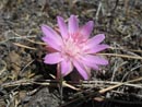
After a mile or so we reached a section of bare rock covered with bitterroot and onions. This was only a taste of what lay above. At about 1 3/4 miles we crossed a creek which was our water supply for the trip. A quarter mile ahead was our campsite. The trail crossed over the nose of a ridge before a gentle descent. We camped just below the trail in a nice meadow. We set up camp and hung our food first. Then we headed out for a little hike up the ridge.
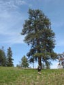
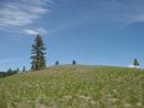
The terrain is grassy with large trees. Most of them are pine with some fir as well. Lightening strikes have left a number of blackened snags along the way. The trailhead is at 2020' and our campsite was at about 2900'. Our objective was Point 3554, about a mile away. Kim was up here a few years back on Memorial Day weekend. She only had one night and was anxious to do more exploring. She had gone as far as Point 3554 on that trip. We reached the point and had nice views of the country around us.
We decided to continue on to the north towards a high point on the ridge. We could see there were a number of ups and down required to get that far. We dropped down then contoured on or below the ridge. There were a number of downed trees to get around. The temperature was in the mid 70s and it was plenty warm. Bugs were not much of a problem. In time we came out on a bare point at just over 3000'. We could see it was still a good distance to our objective and required a steep descent to continue on. We chose instead to take a long break on the point.
I laid down and soon a hummingbird was floating a foot away from my head. Why in the heck would he do that? I couldn't figure it out. When I got up I saw Kim's bright red bandana right behind my head. Doh! On our return we stayed a little higher and missed a lot of the brush and downed logs. It was about 1.80 miles out to the bare point. Upon returning to camp I went off to fill the water bag and then it was time for dinner. Our campsite had an eastern terrace and a southwest terrace. Both had great views out. It is a really neat spot.
The night was hot as my 10 degree sleeping bag proved to be too warm even in my tarptent. In the morning we had some excitement. As I was getting the stove going Kim suddenly screamed. She heard a rattle near our kitchen area. We looked around but did not see the snake. We were a little more carefully after that. She did see another snake near the site that morning but it was not a rattler.
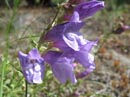
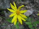
We packed up and headed off to Cougar Mountain. It was only 1.80 miles to where we left the trail but it took a long time. There was just too much to see. Flowers were everywhere. Many of the ones from the first day and dozens more. Kim was excited to see old man's whiskers. She had only seen it once before. We saw it many times on our route. Penstemon, white daisies, death camas, shooting stars, much yellow amica, bluebells, and ball head waterleaf were some of the others. The route crossed a long unused road and climbed to a meadow. There were several large rock cairns there.
A couple on horseback passed us near the meadow. Our route climbed up to the top of a ridge. From there the trail drops to a road then climbs up along an open ridge to near the top of Thirteen Mile Mountain. We stopped for lunch. The horse duo also stopped here. The ridge continues up to the summit of Cougar Mountain. It is fairly gentle and is plastered with flowers.
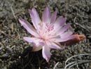
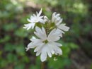
We saw another first here. There were many blooming bitterroot. Some of them were bright white. Not a trace of pink at all. In fact, the flowers casing is yellowish green not dark like other bitterroot. A really unique and beautiful variety of bitterroot. Progress was very slow with all the blooming flowers. We had a very nice view across the valley to the ridge of Thirteen Mile Mountain. I would very much like to hike it some day. The ridge slowly bent around to the left and in due time the summit of Cougar came into view.
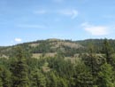
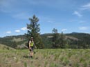
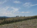
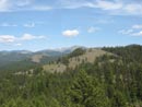
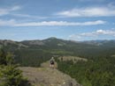
We had a short easy scramble up to the broad and flat summit. Terrific views from here. We could see the bare point we reached the day before. The ridge between us and it was a series of meadows and high points with forested low points in between. We pulled out the map to try to see if the route looked like it would go. The distance was over 3 miles though it did not look all that far from our higher vantage point. Kim knew that an alternate version of the Pacific Northwest Trail followed the first part of the route. After some debating we chose to give the off trail route a shot to complete a loop back to camp.
Within a dozen steps down from the summit I tweaked my left knee. Very painful for a second then not so bad. More debate ensued and I thought it would be okay for the scramble route. On we went. A drop and traverse brought us back to the ridge on the next high point. Another drop and traverse around the next point and we climbed up to a wide down sloping meadow on the ridge top. The topo lines made it appear we could avoid a deep gully to the right of the ridge and continue down it to reach an easier descent to the right. That didn't work.
Farther down the slope to the right got even steeper. It was a cliff with a couple very steep gullies heading on down. Way too steep for us to try. It looked like we may have reached the end of the line. We tried dropping farther down the ridge and in fact we found that it was possible to drop off the left side and reach the forest below. A little steep with loose rock but a very reasonable descent. At the bottom we contoured around the base of the cliff. For some 100' we were on a trail. Animal or otherwise it was wide and easy to follow.
Downed trees ended that and we bushwhacked down to and across the damp valley bottom. We climbed out of the forest and back onto the ridge again. A forested traverse allowed us to not go all the way to the top and we were soon back on the descending ridge. In the forest we found big old pine trees with a carpet of six inch thick bunch grass covering everything. We could now see the bare spot we reached the previous day and it was not far off.
There were several more descents into forest and climbs back to the ridge top. On the next to last one we stopped for a break. As we were getting up Kim noticed a tick on here pack. Not a good sign. The next day we each found a tick on us though not yet dug in. The final drop took us to just under the bare spot. Kim was a short distance behind me when she hollered that she saw another snake. I ran over to see a big rattler very slowly slithering away. We each took a number of photos as he did not seem to be in any hurry to get away. That was the first rattler I have seen in all my years of hiking east of the Cascades.
A short steep ascent brought us back to the ridge we were on the day before. Now it was simple to finish our loop. We did stay a little higher on the ridge and dropped down to a real mess near the end. logs down everywhere and mud. Many cuts later we climbed back up to Point 3554 and followed the ridge back to camp. The loop was only about 7 miles but only 1.80 miles was on a trail. It was some of the best ridge rambling I have done. Add in the immense variety of blooming wild flowers and it was spectacular. Fortunately, I had only a few twinges in my knee and it did not bother me on trail for the rest of the weekend.
That night we had 4 or 5 short blasts of hard rain. My tarptent had no problems. The next morning we broke camp and headed down. The rain brought a number of flowers into bloom that were not blooming when we came up a few days earlier. At the trailhead we found one other car though we never did see those folks. We stopped in Republic for breakfast then headed on to Sherman Pass and part two of the weekend adventure.
Click on thumbnails to get larger pictures.
Photo Page 2
Trips - 2007
Home
There was one other vehicle in the campgrounds. It was now almost completely dark as we set out to round up some wood for a fire. We piled up some thin branches and some paper to get the fire going. The wood was so dry it fired right up. Dinner consisted of salmon, potatoes, corn on the cob, and carrots in aluminum foil thrown into the fire. As the flames settled down we added grilled steak. Amazingly, it all turned out great. Everything done to perfection. Who would think that Kim is also a gourmet cook with a campfire.
By the time we headed to bed it was already near 11:30. In the morning we repacked our backpacks and drove three miles south to the Thirteen Mile Creek trailhead and campgrounds. We were, not surprisingly, the only car in the lot. The trail begins climbing immediately as it ascends along the creek in a narrow gorge. Flowers began with our first steps and never ended for the whole trip. Our route was mostly in forest with a mix of forest and desert flowers. Flowering strawberries were seen on the entire route. Paintbrush and violets gave way to bitterroot and onions. We saw calypso orchids, columbia clematis, scarlet gilia, and also woodland star and larkspur. We were able to identify 26 flowers but saw at least another 40 we could not name. All in all, the colors were magnificent.
After a mile or so we reached a section of bare rock covered with bitterroot and onions. This was only a taste of what lay above. At about 1 3/4 miles we crossed a creek which was our water supply for the trip. A quarter mile ahead was our campsite. The trail crossed over the nose of a ridge before a gentle descent. We camped just below the trail in a nice meadow. We set up camp and hung our food first. Then we headed out for a little hike up the ridge.
The terrain is grassy with large trees. Most of them are pine with some fir as well. Lightening strikes have left a number of blackened snags along the way. The trailhead is at 2020' and our campsite was at about 2900'. Our objective was Point 3554, about a mile away. Kim was up here a few years back on Memorial Day weekend. She only had one night and was anxious to do more exploring. She had gone as far as Point 3554 on that trip. We reached the point and had nice views of the country around us.
We decided to continue on to the north towards a high point on the ridge. We could see there were a number of ups and down required to get that far. We dropped down then contoured on or below the ridge. There were a number of downed trees to get around. The temperature was in the mid 70s and it was plenty warm. Bugs were not much of a problem. In time we came out on a bare point at just over 3000'. We could see it was still a good distance to our objective and required a steep descent to continue on. We chose instead to take a long break on the point.
I laid down and soon a hummingbird was floating a foot away from my head. Why in the heck would he do that? I couldn't figure it out. When I got up I saw Kim's bright red bandana right behind my head. Doh! On our return we stayed a little higher and missed a lot of the brush and downed logs. It was about 1.80 miles out to the bare point. Upon returning to camp I went off to fill the water bag and then it was time for dinner. Our campsite had an eastern terrace and a southwest terrace. Both had great views out. It is a really neat spot.
The night was hot as my 10 degree sleeping bag proved to be too warm even in my tarptent. In the morning we had some excitement. As I was getting the stove going Kim suddenly screamed. She heard a rattle near our kitchen area. We looked around but did not see the snake. We were a little more carefully after that. She did see another snake near the site that morning but it was not a rattler.
We packed up and headed off to Cougar Mountain. It was only 1.80 miles to where we left the trail but it took a long time. There was just too much to see. Flowers were everywhere. Many of the ones from the first day and dozens more. Kim was excited to see old man's whiskers. She had only seen it once before. We saw it many times on our route. Penstemon, white daisies, death camas, shooting stars, much yellow amica, bluebells, and ball head waterleaf were some of the others. The route crossed a long unused road and climbed to a meadow. There were several large rock cairns there.
A couple on horseback passed us near the meadow. Our route climbed up to the top of a ridge. From there the trail drops to a road then climbs up along an open ridge to near the top of Thirteen Mile Mountain. We stopped for lunch. The horse duo also stopped here. The ridge continues up to the summit of Cougar Mountain. It is fairly gentle and is plastered with flowers.
We saw another first here. There were many blooming bitterroot. Some of them were bright white. Not a trace of pink at all. In fact, the flowers casing is yellowish green not dark like other bitterroot. A really unique and beautiful variety of bitterroot. Progress was very slow with all the blooming flowers. We had a very nice view across the valley to the ridge of Thirteen Mile Mountain. I would very much like to hike it some day. The ridge slowly bent around to the left and in due time the summit of Cougar came into view.
We had a short easy scramble up to the broad and flat summit. Terrific views from here. We could see the bare point we reached the day before. The ridge between us and it was a series of meadows and high points with forested low points in between. We pulled out the map to try to see if the route looked like it would go. The distance was over 3 miles though it did not look all that far from our higher vantage point. Kim knew that an alternate version of the Pacific Northwest Trail followed the first part of the route. After some debating we chose to give the off trail route a shot to complete a loop back to camp.
Within a dozen steps down from the summit I tweaked my left knee. Very painful for a second then not so bad. More debate ensued and I thought it would be okay for the scramble route. On we went. A drop and traverse brought us back to the ridge on the next high point. Another drop and traverse around the next point and we climbed up to a wide down sloping meadow on the ridge top. The topo lines made it appear we could avoid a deep gully to the right of the ridge and continue down it to reach an easier descent to the right. That didn't work.
Farther down the slope to the right got even steeper. It was a cliff with a couple very steep gullies heading on down. Way too steep for us to try. It looked like we may have reached the end of the line. We tried dropping farther down the ridge and in fact we found that it was possible to drop off the left side and reach the forest below. A little steep with loose rock but a very reasonable descent. At the bottom we contoured around the base of the cliff. For some 100' we were on a trail. Animal or otherwise it was wide and easy to follow.
Downed trees ended that and we bushwhacked down to and across the damp valley bottom. We climbed out of the forest and back onto the ridge again. A forested traverse allowed us to not go all the way to the top and we were soon back on the descending ridge. In the forest we found big old pine trees with a carpet of six inch thick bunch grass covering everything. We could now see the bare spot we reached the previous day and it was not far off.
There were several more descents into forest and climbs back to the ridge top. On the next to last one we stopped for a break. As we were getting up Kim noticed a tick on here pack. Not a good sign. The next day we each found a tick on us though not yet dug in. The final drop took us to just under the bare spot. Kim was a short distance behind me when she hollered that she saw another snake. I ran over to see a big rattler very slowly slithering away. We each took a number of photos as he did not seem to be in any hurry to get away. That was the first rattler I have seen in all my years of hiking east of the Cascades.
A short steep ascent brought us back to the ridge we were on the day before. Now it was simple to finish our loop. We did stay a little higher on the ridge and dropped down to a real mess near the end. logs down everywhere and mud. Many cuts later we climbed back up to Point 3554 and followed the ridge back to camp. The loop was only about 7 miles but only 1.80 miles was on a trail. It was some of the best ridge rambling I have done. Add in the immense variety of blooming wild flowers and it was spectacular. Fortunately, I had only a few twinges in my knee and it did not bother me on trail for the rest of the weekend.
That night we had 4 or 5 short blasts of hard rain. My tarptent had no problems. The next morning we broke camp and headed down. The rain brought a number of flowers into bloom that were not blooming when we came up a few days earlier. At the trailhead we found one other car though we never did see those folks. We stopped in Republic for breakfast then headed on to Sherman Pass and part two of the weekend adventure.
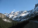
Near Washington Pass |
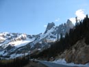
Liberty Bell |
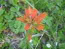
Orange Paintbrush |
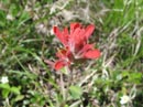
Red Paintbrush |
Columbia Clematis |
Lavender |
First Bitterroot |
More Colorful |
Twins |
Yellow |
Star Flower |
Scramble View |
Balsamroot |
Big Pine |
Thirteen Mile Mt. |
Open Ridge |
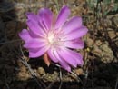
More Bitterroot |
Parallel Ridge |
Scramble Route |
Kim On The Edge |
Photo Page 2
Trips - 2007
Home