2-23-08
Suzanne suggested Lichtenberg Mountain for Saturday.
She had made it as far as Lichtenwasser Lake once before time constraints
cut short her trip. David had been a little beyond the lake before turning
back. Suzanne, Barry, and I headed out to meet David, Fran, and Jack at
the Smith Brook trailhead. We arranged to meet at 9:00 AM. Suzanne just moved
and could not find her snowshoes. That meant after meeting her we backtracked
to my place to get another pair for her. By the time we picked up Barry
we were running a little late.
By the time we reached Gold Bar David called to say he was running late. We were actually a few miles ahead of him. Just before Scenic traffic came to a complete halt. A check of the radio confirmed a rollover accident just ahead of us. We waited. And waited. And waited. After about an hour traffic was moving again. So much for getting up at 6:00 AM. It was 10:30 by the time we reached Smith Brook. The elevation is about 3170'. There was only one other car and the occupants were getting ready to start skiing. We inquired and they were heading to Lichtenberg Mountain. Looked like we would have tracks to follow. Seems they had not been there either though.
Another big group arrived just after us. They were an Everett Parks and Recreation group led by Alpine Andy. I had seen his website years back. We moved out just ahead of the big group at 10:45.
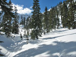
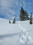
Smith Brook Road was well packed down. We did not need snowshoes for the entire road walk. We played leap frog with one of the skiers. On the positive side, the forecast was for mostly sunny and we had almost entirely sunny. It was right around 32 degrees when we began and warmed up as the day went by. The section from the road end to the lake was the most interesting. Suzanne found a moderate route on her previous visit. The other members of that group took a much harder route and she reached the lake more than half an hour before them.
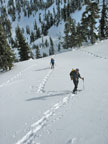
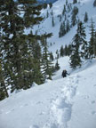
David remembered a slightly harder route but not too difficult. We followed ski tracks into the forest. The immediate creek crossing was easy as the whole creek is under a bridge of snow. After about 10 minutes we opted to don our snowshoes. The route continued off to our right at a moderate grade. Then the grade became much steeper. We were to the left of what we thought was the lake's outlet creek. Except it wasn't. Soon we were making long sidehill traverses and switchbacks. In places I was lucky to get half a snowshoe to bite on the steep slope.
The snow was mostly soft with some very hard patches. David had mentioned a very steep short section. Well it went on and on. We climbed a few hundred feet on this crap before some moderation. At long last we topped out, made a few ups and downs, and descended to Lichtenwasser Lake. I was not looking forward to descending the route he had come up.
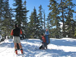
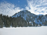
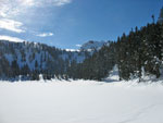
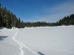
The lake is covered by many feet of snow. It was in bright sunshine. After the climb we were all pretty warm. This was a good place to stop for lunch. With our late start it was nearly 1:00 PM already. I was not feeling that great so I headed off first across the lake. We had met the skiers again at the lake and they headed off first. I followed their tracks. The track was near the right (west) shore and took me to the southwest corner of the 4704' lake.
Suzanne's dog Gusto followed me. A few minutes later the rest of the group arrived. Now things became more interesting. Only David had been beyond the lake and he did not go far. We were on our own now. I read a dozen trip reports online and none of them seemed to correlate with what I saw above us. On the positive side we saw the big Everett group reach the lake. The group was open to all and I could not believe they came up a route as difficult as ours. They must have known a better route. We planned to follow their prints back down.
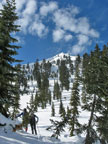
The Everett group is run by Alpine Andy. He has managed to make a job out of leading hikes. More power to him. His site with info on Everett Parks trips and a schedule is at: AlpineAndy.com . We followed the ski tracks up a drainage angling a little to our right. Now we could see the summit and the ridges to it's right and left. The left ridge looked gentler on top but was extremely corniced. The ridge to the right looked steeper to attain and steeper near the summit but with no cornices. We chose to leave the ski tracks and head to our right and the ridge right of the summit. This would be the northeast ridge The other ridge trended to the southeast.
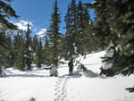
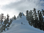
Our route began to get steeper. Then it became even steeper. nearer the ridge it became steeper still. The snow was soft enough to put in a pretty good snowshoe step but did break away a bit. It seemed too soft to kick steps in boots alone. Fran became uncomfortable and chose to head farther left in hopes of finding gentler terrain. Our route finally moderated just before reaching the ridge.
From the ridge top we were a few hundred feet at most below the summit. We could see the last 50' were very steep. Too steep for these snow conditions. Jack and Suzanne went around the summit block on the right (north) side. A very steep but open slope seemed to go to the top. It seemed a little too steep for our group. We headed back to the ridge then dropped down below the summit into a high basin. Straight up looked possible but again became extremely steep the last 50'. We considered calling it a day and heading back down. I could see a notch on the southeast ridge that broke the line of cornices. Barry and I chose to head over and see if we could climb it and if the southeast ridge was a walk up.
Barry went ahead and I followed. Right below the notch was steep but no worse than we had done earlier. We popped up on the ridge top and could see a very moderate slope up to the summit. We yelled back to the others and they began to head our way. One thing we could see on the ridge was that several cornices had long deep cracks. Not much is holding them up. We made sure to stay well to the left of them. The rest of the group soon arrived and we headed on up. In short order we were on the summit. It was already 2:45 so we did not have much time to spend on top. With our detours it took us 4 hours to summit.
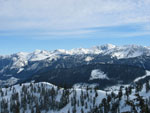
We made sure to get photos of the amazing 360 degree view. There are no taller peaks nearby so we could see from Mt. Baker to Sloan to Glacier Peak to McCausland right next door and on to Rock, Stuart, Daniel, and multitudes more. There were now some high clouds but mostly blue sky. The wind picked up on the ridge top and it was chilly on top. After all too short a stay we headed down. At the notch in the ridge we took off snowshoes and plunge stepped on down. It was steep but the snow was now soft enough to provide solid steps.
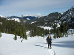
We reached a bench then went left then right to get through trees and back onto open slopes. In very short order we were back on our route up. We went back to snowshoes and dropped to the lake. I finished my lunch at the lake and we had no trouble finding the tracks of the dozen Everett snowshoers. Thank you Alpine Andy. The route we took down was much easier than our route up. Very little sidehilling and we even glissaded a few short steep sections. It really did not take long to reach the road once again.
Most of us took off our snowshoes here. The road had softened up in the sunshine but most of it was in shady forest. After a little postholing we were back in trees and the track became hard once again. Any road walk at the end of a climb seems to go on and on and this one is no exception. We stumbled back to the top of the 10 foot snow wall above the highway at 4:55. It took us almost exactly two hours to descend from the summit. For the day we traveled about 8 miles with 2900' gained.
What a terrific day! Blue sky and blindingly white snow. Some challenging terrain and some route finding questions. We had to puzzle out just how to get that last bit to the summit. After a dismal record of failures David and I have now reached our objective three weeks in a row. It seems like that curse is over. I hope for at least a few winter climbs where the sky is blue and the white clad peaks are laid out in all their splendor. This one certainly qualified. For Gusto, it was the first of many summits to come. Thanks to Suzanne for the destination and to everyone else for making it such a memorable day.
David has his report and photos posted here: Nwhikers Report And Photos
Click on thumbnails to get larger pictures.
Photo Page 2
Trips - 2008
Home
By the time we reached Gold Bar David called to say he was running late. We were actually a few miles ahead of him. Just before Scenic traffic came to a complete halt. A check of the radio confirmed a rollover accident just ahead of us. We waited. And waited. And waited. After about an hour traffic was moving again. So much for getting up at 6:00 AM. It was 10:30 by the time we reached Smith Brook. The elevation is about 3170'. There was only one other car and the occupants were getting ready to start skiing. We inquired and they were heading to Lichtenberg Mountain. Looked like we would have tracks to follow. Seems they had not been there either though.
Another big group arrived just after us. They were an Everett Parks and Recreation group led by Alpine Andy. I had seen his website years back. We moved out just ahead of the big group at 10:45.
Smith Brook Road was well packed down. We did not need snowshoes for the entire road walk. We played leap frog with one of the skiers. On the positive side, the forecast was for mostly sunny and we had almost entirely sunny. It was right around 32 degrees when we began and warmed up as the day went by. The section from the road end to the lake was the most interesting. Suzanne found a moderate route on her previous visit. The other members of that group took a much harder route and she reached the lake more than half an hour before them.
David remembered a slightly harder route but not too difficult. We followed ski tracks into the forest. The immediate creek crossing was easy as the whole creek is under a bridge of snow. After about 10 minutes we opted to don our snowshoes. The route continued off to our right at a moderate grade. Then the grade became much steeper. We were to the left of what we thought was the lake's outlet creek. Except it wasn't. Soon we were making long sidehill traverses and switchbacks. In places I was lucky to get half a snowshoe to bite on the steep slope.
The snow was mostly soft with some very hard patches. David had mentioned a very steep short section. Well it went on and on. We climbed a few hundred feet on this crap before some moderation. At long last we topped out, made a few ups and downs, and descended to Lichtenwasser Lake. I was not looking forward to descending the route he had come up.
The lake is covered by many feet of snow. It was in bright sunshine. After the climb we were all pretty warm. This was a good place to stop for lunch. With our late start it was nearly 1:00 PM already. I was not feeling that great so I headed off first across the lake. We had met the skiers again at the lake and they headed off first. I followed their tracks. The track was near the right (west) shore and took me to the southwest corner of the 4704' lake.
Suzanne's dog Gusto followed me. A few minutes later the rest of the group arrived. Now things became more interesting. Only David had been beyond the lake and he did not go far. We were on our own now. I read a dozen trip reports online and none of them seemed to correlate with what I saw above us. On the positive side we saw the big Everett group reach the lake. The group was open to all and I could not believe they came up a route as difficult as ours. They must have known a better route. We planned to follow their prints back down.
The Everett group is run by Alpine Andy. He has managed to make a job out of leading hikes. More power to him. His site with info on Everett Parks trips and a schedule is at: AlpineAndy.com . We followed the ski tracks up a drainage angling a little to our right. Now we could see the summit and the ridges to it's right and left. The left ridge looked gentler on top but was extremely corniced. The ridge to the right looked steeper to attain and steeper near the summit but with no cornices. We chose to leave the ski tracks and head to our right and the ridge right of the summit. This would be the northeast ridge The other ridge trended to the southeast.
Our route began to get steeper. Then it became even steeper. nearer the ridge it became steeper still. The snow was soft enough to put in a pretty good snowshoe step but did break away a bit. It seemed too soft to kick steps in boots alone. Fran became uncomfortable and chose to head farther left in hopes of finding gentler terrain. Our route finally moderated just before reaching the ridge.
From the ridge top we were a few hundred feet at most below the summit. We could see the last 50' were very steep. Too steep for these snow conditions. Jack and Suzanne went around the summit block on the right (north) side. A very steep but open slope seemed to go to the top. It seemed a little too steep for our group. We headed back to the ridge then dropped down below the summit into a high basin. Straight up looked possible but again became extremely steep the last 50'. We considered calling it a day and heading back down. I could see a notch on the southeast ridge that broke the line of cornices. Barry and I chose to head over and see if we could climb it and if the southeast ridge was a walk up.
Barry went ahead and I followed. Right below the notch was steep but no worse than we had done earlier. We popped up on the ridge top and could see a very moderate slope up to the summit. We yelled back to the others and they began to head our way. One thing we could see on the ridge was that several cornices had long deep cracks. Not much is holding them up. We made sure to stay well to the left of them. The rest of the group soon arrived and we headed on up. In short order we were on the summit. It was already 2:45 so we did not have much time to spend on top. With our detours it took us 4 hours to summit.
We made sure to get photos of the amazing 360 degree view. There are no taller peaks nearby so we could see from Mt. Baker to Sloan to Glacier Peak to McCausland right next door and on to Rock, Stuart, Daniel, and multitudes more. There were now some high clouds but mostly blue sky. The wind picked up on the ridge top and it was chilly on top. After all too short a stay we headed down. At the notch in the ridge we took off snowshoes and plunge stepped on down. It was steep but the snow was now soft enough to provide solid steps.
We reached a bench then went left then right to get through trees and back onto open slopes. In very short order we were back on our route up. We went back to snowshoes and dropped to the lake. I finished my lunch at the lake and we had no trouble finding the tracks of the dozen Everett snowshoers. Thank you Alpine Andy. The route we took down was much easier than our route up. Very little sidehilling and we even glissaded a few short steep sections. It really did not take long to reach the road once again.
Most of us took off our snowshoes here. The road had softened up in the sunshine but most of it was in shady forest. After a little postholing we were back in trees and the track became hard once again. Any road walk at the end of a climb seems to go on and on and this one is no exception. We stumbled back to the top of the 10 foot snow wall above the highway at 4:55. It took us almost exactly two hours to descend from the summit. For the day we traveled about 8 miles with 2900' gained.
What a terrific day! Blue sky and blindingly white snow. Some challenging terrain and some route finding questions. We had to puzzle out just how to get that last bit to the summit. After a dismal record of failures David and I have now reached our objective three weeks in a row. It seems like that curse is over. I hope for at least a few winter climbs where the sky is blue and the white clad peaks are laid out in all their splendor. This one certainly qualified. For Gusto, it was the first of many summits to come. Thanks to Suzanne for the destination and to everyone else for making it such a memorable day.
David has his report and photos posted here: Nwhikers Report And Photos
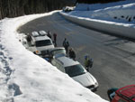
Parking Lot |
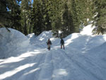
Smith Brook Road |
Skiers Near Lake |
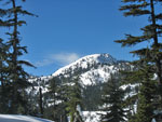
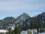
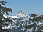
Mt. McCausland |
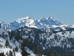
A Peak Above Lake |
Lichtenwasser Lake |
Crossing Lake |
Starting Up |
Southeast Ridge |
Summit |
David (Opus) |
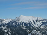
Peak Behind Lake |
Fran & David |
Steep |
Almost To Ridge |
Suzanne & Summit |
View From Ridge |
Sloan Peak |
Columbia & Monte Cristo |
Rock Mountain |
Photo Page 2
Trips - 2008
Home