2-16-08
Sometimes you need to be flexible. Our group set out
to climb Silver Peak via the Annette Lake trail up to the railroad grade.
The others had tried it a month earlier. That was before the big snowfall
we have been buried under. They made it close to the summit and looked forward
to reaching the top this time. We pulled off I-90 at the Denny Creek exit.
To the right is a road across the SF Snoqualmie River then on to the Annette
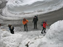
trailhead. Not anymore. Now there is a 20 foot tall snow and ice pile thoroughly
blocking the road. There was maybe space for one car. We drove across the
overpass to park or head down to the Pratt Lake trailhead. No this day.
The Pratt trailhead is adjacent to the WSDOT lot where sand and snow plow
trucks are kept. I had never seen this short road not plowed. It was this
day.
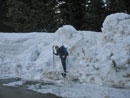
There were a few cars parked mostly off the road but not entirely. The only other place to park was in the road heading towards the Denny Creek trailhead. I recommended not parking there. Since parking anywhere would be illegal the chance of tickets for each of us or a towed away car was all to likely. Now what to do? Plan B became the Nordic Pass Trail and a shot at the summit of Mt. Catherine. We drove over the pass to the Hyak exit. With some 100" of snow fall in the previous two weeks we were not sure if snowshoes would keep us above the snow.
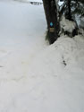
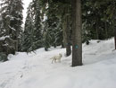
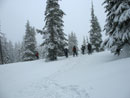
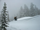
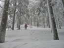
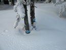
We walked up the road from Hyak to the sharp left turn in the road and looked for a place to get up the 15 foot tall snow wall. In fact there was a break that allowed us easy access to the top. The first and often biggest problem is getting across the creek. Not a problem this time. The entire creek is under snow. We walked right across. The Nordic Pass sign on the other side of the creek is now only a foot or so above the snow. I had not seen this much snow on the trail.
Bob, Kolleen, and I had summitted Catherine in 2006. Earlier Suzanne and I had been forced to give up just some 50 feet below the top. We followed the track laid by some intrepid solo snowshoer who also had turned around there. That someone turned out to be David who was also on this trip. He had failed a few other times and was the most determined to reach the top this time.
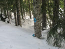
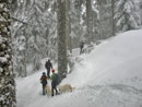
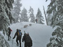
Our group of seven humans included Bob, Kolleen, David, Tom, Joanna, and Bruce. We also had four dogs along. My biggest fear proved to be unfounded. We sank only some 3 - 6 inches into the snow. Rain earlier in the week had helped to consolidate the snow to a remarkable degree. David and I were in a group on this route in mid December. There was only a fraction of the snow but it was soft. We made much better progress after all the recent snow. The rain also removed much of the snow from branches and tree trunks. This time we had only on short problem area following the blue diamonds.
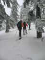
Some of the diamonds were only a few inches above the snow. Most winters they are at eye level or higher. We reached the old railroad grade and turned off it heading higher. Very soon we met snowshoe tracks. These followed the Nordic Pass trail on up to Hyak Lake. They made it that much easier for us. It is always tough to pick up the trail on the other side of Intermountain 90, the big groomed ski cross over road. It is a little to the right after crossing the road. This time Bob was quick to spot a diamond in the trees above.
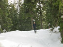
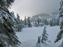
The forecast was for some morning clouds turning to sunny skies in the afternoon. Well, it was plenty dark and gloomy all the way up. We passed Hyak Lake and another ski crossover trail. As we neared the upper power line corridor the route became harder to follow. We continued on under the power lines guessing where we should be. I though farther left and Tom thought further right. We compromised in the middle and hit the main groomed ski trail at another blue diamond. It was mostly just luck but it really helped.
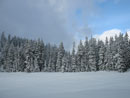
The key is to leave the nordic ski area following blue diamonds. It is much harder to find Nordic Pass without the markers. We left the ski trail at a familiar meadow but could not find the next diamond. We fanned out and found it off to our left. Now back on track we continued on towards Frog Lake. In December we had problems crossing downed logs. Not anymore. Now all obstacles are buried under 10+ feet of snow.
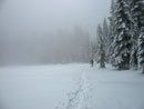
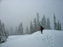
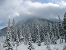
We passed Frog Lake and I think I recognized Dick Creek though there was no creek, just a flat snowy meadow. The grade grew a little steeper nearing the pass though it is never really steep at all. A little before noon we crested the pass. We did not see the Nordic Pass sign. Either we just missed it or it is now under the snow cover. It took la little over 3 hours to reach the pass. Not bad after all the new snow. I did not expect to have time to reach Mt Catherine when we started but now it looked very possible. After a short food and water break we were on the move again.
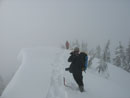
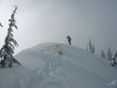
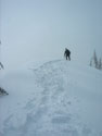
We dropped down to the weather station then began the climb up. There were a few recent ski tracks at the pass but no snowshoe tracks. No tracks headed up the ridge of Mt. Catherine. The climb starts steeply. The snow was very good for climbing. It was soft on top but packed down well. After a very short 300' climb the ridge became more gentle. It is a full mile from Nordic Pass to the summit gaining 1000' net. There are a few small ups and downs on the ridge as well.
On my previous two times on the ridge there were some icy spots. This time it was good snow all the way. We were able to stay on the ridge top nearly all the way. With a GPS reading of only .15 miles to go Bruce's MSR snowshoe broke. The binding was still on his boot but the snowshoe was not. He chose to take off the other snowshoe and posthole on. The snow was well consolidated but he still broke through. Having the other 6 of us ahead did help to pack down the snow.
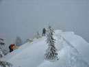
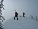
In just a few minutes we reached that all to familiar place some 50 vertical feet below the summit. The first time David then Suzanne and I had tried the right side but failed in rotten snow. The second time Bob, Kolleen, and I went left following a single ski track. It was very steep side hilling but the snow was perfect for stomping out a ledge. This time it was a little too hard to go safely around left on a level traverse. We split up. Some looked right and some left. Tom led a recon to the left and Bob to the right. I went right, left, and back to the right. By then Bob was out of side climbing a very steep snow pitch. When I went back left, Tom and Joanna were gone.
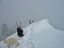
I chose to follow the track nearly straight up on the left side of the ridge. It was steep but less so than the right side. This in fact worked very well. Kolleen followed my and up we went. I reached the ridge, climbed on short step, and had clear sailing ahead. I soon reached the track Bob then David had come up on the right. It looked much steeper from above. In short order we all reached the top. The summit is really just the highest point on a fairly level ridge. There was sloping snow on one side and a drop off on the other. There was a bit of a cornice as well.
The dogs were all leashed to keep them away from the cornice. We had had some cold wind on the ridge but it was almost calm on top. Unfortunately, the forecast clearing did not happen. We had a few sucker holes of blue but no visibility around us. Silver Peak was right across but we never saw any of it. It was after 1:00 PM when we summitted but we were in good shape to get down before dark. As we broke out the rest of our lunches Bruce came into sight. He was determined to summit and he did.
We all chose to come down the less steep side of the ridge. Some went up the last part with snowshoes and some without. Both methods worked fine. Once back on the lower ridge we adjusted gear and packed up. Mostly that was stowing ice axes and taking poles back out. The summit is no place to go without an ice axe. We made much better time coming down. Bruce was a bit slower due to postholing but he did fine.
Once back at Nordic Pass Bruce rigged up make shift binding for his snowshoe. It required a number of stops for adjustments but it worked all the way back down. By the time we reached the upper power line corridor it had cleared enough to see part of Mt. Catherine. Not blue sky but not as dark as it was on the way up. At Hyak Lake it was much brighter. We met two campers at the lake. Up to that point the only people we had seen were a few skiers on the groomed tracks.
As is usual we did meet a few groups in the first mile who were heading up. We made it back to the car at around 4:15. Our December trip started and ended at very similar times. The difference is that this time we added the distance from Nordic Pass to the summit of Catherine and back. Also it was almost dark at 4:15 in mid December. This time we had more than an hour of daylight left. For the day we hiked a little over 9 miles with about 2800' of gain.
The trip we did was not the trip we planned but it worked out great. The snow was far more consolidated than I expected. That allowed us to maintain a good pace. The summit of Catherine is a crap shoot. If the snow is good you can summit. If not it is way too dangerous for my ability. We had very good snow this day. It was a fun group and a fun time. Also, it looks like the curse put on any trip I do with David seems to be over. We failed at everything including Snow Lake together. Last week we made it up Mt. Si and now Mt. Catherine. This thing was as hard to break as the Trail Pair summit curse. That one was a near guarantee of no views through the clouds. Hopefully the recent enormous avalanche danger is over and we can get back to more summits this winter.
David's report can be found here: Nwhikers Report & Photos
Click on thumbnails to get larger pictures.
Trips - 2008
Home
There were a few cars parked mostly off the road but not entirely. The only other place to park was in the road heading towards the Denny Creek trailhead. I recommended not parking there. Since parking anywhere would be illegal the chance of tickets for each of us or a towed away car was all to likely. Now what to do? Plan B became the Nordic Pass Trail and a shot at the summit of Mt. Catherine. We drove over the pass to the Hyak exit. With some 100" of snow fall in the previous two weeks we were not sure if snowshoes would keep us above the snow.
We walked up the road from Hyak to the sharp left turn in the road and looked for a place to get up the 15 foot tall snow wall. In fact there was a break that allowed us easy access to the top. The first and often biggest problem is getting across the creek. Not a problem this time. The entire creek is under snow. We walked right across. The Nordic Pass sign on the other side of the creek is now only a foot or so above the snow. I had not seen this much snow on the trail.
Bob, Kolleen, and I had summitted Catherine in 2006. Earlier Suzanne and I had been forced to give up just some 50 feet below the top. We followed the track laid by some intrepid solo snowshoer who also had turned around there. That someone turned out to be David who was also on this trip. He had failed a few other times and was the most determined to reach the top this time.
Our group of seven humans included Bob, Kolleen, David, Tom, Joanna, and Bruce. We also had four dogs along. My biggest fear proved to be unfounded. We sank only some 3 - 6 inches into the snow. Rain earlier in the week had helped to consolidate the snow to a remarkable degree. David and I were in a group on this route in mid December. There was only a fraction of the snow but it was soft. We made much better progress after all the recent snow. The rain also removed much of the snow from branches and tree trunks. This time we had only on short problem area following the blue diamonds.
Some of the diamonds were only a few inches above the snow. Most winters they are at eye level or higher. We reached the old railroad grade and turned off it heading higher. Very soon we met snowshoe tracks. These followed the Nordic Pass trail on up to Hyak Lake. They made it that much easier for us. It is always tough to pick up the trail on the other side of Intermountain 90, the big groomed ski cross over road. It is a little to the right after crossing the road. This time Bob was quick to spot a diamond in the trees above.
The forecast was for some morning clouds turning to sunny skies in the afternoon. Well, it was plenty dark and gloomy all the way up. We passed Hyak Lake and another ski crossover trail. As we neared the upper power line corridor the route became harder to follow. We continued on under the power lines guessing where we should be. I though farther left and Tom thought further right. We compromised in the middle and hit the main groomed ski trail at another blue diamond. It was mostly just luck but it really helped.
The key is to leave the nordic ski area following blue diamonds. It is much harder to find Nordic Pass without the markers. We left the ski trail at a familiar meadow but could not find the next diamond. We fanned out and found it off to our left. Now back on track we continued on towards Frog Lake. In December we had problems crossing downed logs. Not anymore. Now all obstacles are buried under 10+ feet of snow.
We passed Frog Lake and I think I recognized Dick Creek though there was no creek, just a flat snowy meadow. The grade grew a little steeper nearing the pass though it is never really steep at all. A little before noon we crested the pass. We did not see the Nordic Pass sign. Either we just missed it or it is now under the snow cover. It took la little over 3 hours to reach the pass. Not bad after all the new snow. I did not expect to have time to reach Mt Catherine when we started but now it looked very possible. After a short food and water break we were on the move again.
We dropped down to the weather station then began the climb up. There were a few recent ski tracks at the pass but no snowshoe tracks. No tracks headed up the ridge of Mt. Catherine. The climb starts steeply. The snow was very good for climbing. It was soft on top but packed down well. After a very short 300' climb the ridge became more gentle. It is a full mile from Nordic Pass to the summit gaining 1000' net. There are a few small ups and downs on the ridge as well.
On my previous two times on the ridge there were some icy spots. This time it was good snow all the way. We were able to stay on the ridge top nearly all the way. With a GPS reading of only .15 miles to go Bruce's MSR snowshoe broke. The binding was still on his boot but the snowshoe was not. He chose to take off the other snowshoe and posthole on. The snow was well consolidated but he still broke through. Having the other 6 of us ahead did help to pack down the snow.
In just a few minutes we reached that all to familiar place some 50 vertical feet below the summit. The first time David then Suzanne and I had tried the right side but failed in rotten snow. The second time Bob, Kolleen, and I went left following a single ski track. It was very steep side hilling but the snow was perfect for stomping out a ledge. This time it was a little too hard to go safely around left on a level traverse. We split up. Some looked right and some left. Tom led a recon to the left and Bob to the right. I went right, left, and back to the right. By then Bob was out of side climbing a very steep snow pitch. When I went back left, Tom and Joanna were gone.
I chose to follow the track nearly straight up on the left side of the ridge. It was steep but less so than the right side. This in fact worked very well. Kolleen followed my and up we went. I reached the ridge, climbed on short step, and had clear sailing ahead. I soon reached the track Bob then David had come up on the right. It looked much steeper from above. In short order we all reached the top. The summit is really just the highest point on a fairly level ridge. There was sloping snow on one side and a drop off on the other. There was a bit of a cornice as well.
The dogs were all leashed to keep them away from the cornice. We had had some cold wind on the ridge but it was almost calm on top. Unfortunately, the forecast clearing did not happen. We had a few sucker holes of blue but no visibility around us. Silver Peak was right across but we never saw any of it. It was after 1:00 PM when we summitted but we were in good shape to get down before dark. As we broke out the rest of our lunches Bruce came into sight. He was determined to summit and he did.
We all chose to come down the less steep side of the ridge. Some went up the last part with snowshoes and some without. Both methods worked fine. Once back on the lower ridge we adjusted gear and packed up. Mostly that was stowing ice axes and taking poles back out. The summit is no place to go without an ice axe. We made much better time coming down. Bruce was a bit slower due to postholing but he did fine.
Once back at Nordic Pass Bruce rigged up make shift binding for his snowshoe. It required a number of stops for adjustments but it worked all the way back down. By the time we reached the upper power line corridor it had cleared enough to see part of Mt. Catherine. Not blue sky but not as dark as it was on the way up. At Hyak Lake it was much brighter. We met two campers at the lake. Up to that point the only people we had seen were a few skiers on the groomed tracks.
As is usual we did meet a few groups in the first mile who were heading up. We made it back to the car at around 4:15. Our December trip started and ended at very similar times. The difference is that this time we added the distance from Nordic Pass to the summit of Catherine and back. Also it was almost dark at 4:15 in mid December. This time we had more than an hour of daylight left. For the day we hiked a little over 9 miles with about 2800' of gain.
The trip we did was not the trip we planned but it worked out great. The snow was far more consolidated than I expected. That allowed us to maintain a good pace. The summit of Catherine is a crap shoot. If the snow is good you can summit. If not it is way too dangerous for my ability. We had very good snow this day. It was a fun group and a fun time. Also, it looks like the curse put on any trip I do with David seems to be over. We failed at everything including Snow Lake together. Last week we made it up Mt. Si and now Mt. Catherine. This thing was as hard to break as the Trail Pair summit curse. That one was a near guarantee of no views through the clouds. Hopefully the recent enormous avalanche danger is over and we can get back to more summits this winter.
David's report can be found here: Nwhikers Report & Photos
Leaving Road |
Nordic Pass Sign |
Left Turn |
Tom & Jasper |

Shadows |
White On White |
Cloudy Meadow |
Hyak Lake |

Another Sign |
Deep Snow |
Nordic Pass |

Weather Station |
Heading Up |
Windy Pass |
On The Ridge |
Nearing Summit Block |
Approaching Summit |
David Near Summit |
Camera Face Off |
Bob On Top |
Joanna |
Bruce Arrives |

Heading Back |
Back On Ridge |
Easy Descent |
Catherine Summit |
Hyak Lake-Blue |
Hyak Lake-Clouds |
Almost Buried |
Climbing Down |
Trips - 2008
Home