9-28-08
I had been up
Mt. David three times before. This is one of my favorite fall hikes. It
has a terrific high ridge walk and great colors. The leaves were on
fire this day. Most of the way is on a nice trail and the final
scramble is not very hard. I have also not seen very many folks on this
trail. This day we saw two others on the route. Of course, the 14 miles
and 5800' of gain keeps a lot of people away.
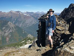
Gary was interested in another trip to David and the forecast was outstanding. Warm for a late September day with little wind. We met in Bothell at 5:15 am as it's both a long drive and long hike. Traffic was negligible and we made great time. It took us less than two hours from Bothell, past Lake Wenatchee, and on to the 2300' trailhead at end of the White River Road. It was a less than balmy 36 degrees when we hit the trail at 7:30. The route crosses the river then heads downstream for the first mile. We set a fast pace trying to warm up and reached the one mile junction with the Panther Creek Trail in 18 minutes. Since my first visit in 2001 the Panther Creek Trail has become very overgrown.
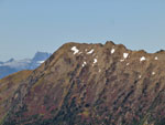
Soon we were heading uphill. The next three miles gain 3000' to the ridge top. The one brushy area was recently brushed out and nearly all logs have been removed. There was one recent fall but it is not a problem. The trail is very smooth and consistently graded. The numbers say there is 1000' gained per mile but it feels like much less. Higher up we had some views out as the forest thinned.
About 3/4 of a mile from the ridge I felt a sharp pain on my ankle. A minute later I had another one. Turned out to be two hornet stings. That is a risk hiking most anywhere in the mountains this time of year. It's the first time I have had two at once and in nearly the same spot. As is often the case, Gary riled them up and the second person got the stings. At least the pain of the stings took my mind off the many switchbacks.
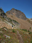
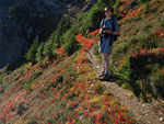
On my first time up the trail I reached the ridge top in 2:15. The second time it was 2:15. The last time it took 2:14. I am consistent. This time we hit the ridge top in 2:01. I guess that first fast mile made the difference. It warmed up quickly as we hiked up from the valley bottom. I was soon in shorts and short sleeves and stayed that way until the summit. The ridge walk is a joy. We still had 3 miles and over 2000' to gain but the trail provided great views and great fall colors.
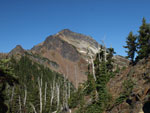
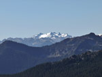
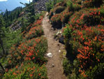
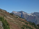
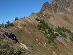
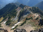
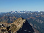
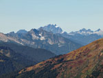
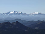
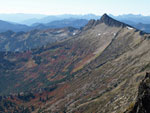
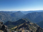
The route goes from one side of the ridge to the other several times. It falls well below the ridge then climbs back up to the top. It is in forest then open meadows then crosses talus fields. The variety is terrific. We had a nice view over to Clark Mountain early on. When on the left side of the ridge we saw Poets Ridge with huge meadows below Whittier Peak. Higher up Mts. Daniel and Hinman came into view. Mt. Rainier sat atop Hinman. Of course, Mt. Stuart was visible though the Jack Creek fire was sending smoke to the west.
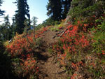
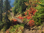
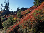
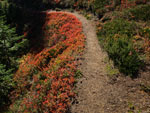
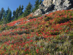
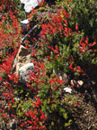
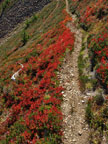
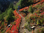
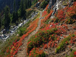
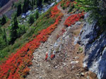
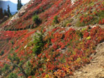
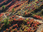
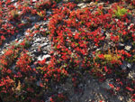
The sun was behind us as we hiked to the west. The berry bushes were a dull red ahead of us but when we looked back the backlighting set them on fire. They looked to be right about at their peak. The colors were so outstanding that we spent more time looking at them and photographing than hiking. Our pace fell to a crawl. All that elevation gain earlier might have had something to do with it too.
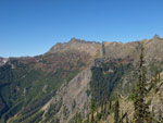
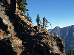
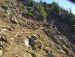
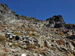
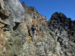
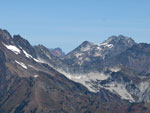
We crossed back to the south side of the ridge and hiked up the steep gully. This route is safe enough though there are loose rocks and it's better not to have another group above you. Back at the ridge top we had a nice look across to Mt. Maude and Seven Fingered Jack. We could also see about a mile of the trail laid out below us. This last northeast side section often holds some snow into September. We did see snow but the route itself is snow free. As we climbed back up to the final saddle below the summit Gary and I were running out of gas.
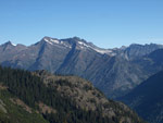
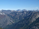
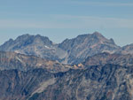
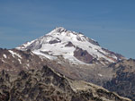
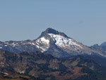
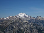
I have not done as many long trips with high elevation gain as usual this year. This was 1000' more than any other trip. I really felt it here. We slowly scrambled up the last section to the summit. What a view! Glacier Peak is visible for the first time and it is close. There is more late season snow on the south side of Glacier this year than any I can recall. There was still not a cloud in the sky. We looked out to Sloan Peak, the Monte Cristo Peaks, Three Fingers, Whitehorse, and even to Olympic Mountains far in the distance.
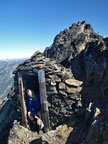
Unlike on my other visits there was no summit register this time. We put on warm clothes and had lunch. With our early start we had plenty of time to enjoy the summit. We were able to look closer to see Kodak Peak and Johnson Mountain, two summits we reached on our Pilot Ridge backpacking trip in 2003. We took the very short trip over to the ig"loo", the stone outhouse on the summit. It sure has a great view. All totaled we spent 1:40 on top. It was a perfect day to sit at 7420' and enjoy the mountains.
We dropped back down to the saddle and met a lone hiker coming up. A few minutes later we met another lone hiker near the ridge top. They were the only other hikers we saw all day. Heading back much of the route on the north side of the ridge was in shade. It was a warm afternoon and that was fine. It did limit the bright red leaves we saw on the way in. With less to photograph we knocked nearly an hour off our time along the ridge. Of course it was mostly downhill too.
Back at the first place we reached the ridge it was time for a last break and look at all the peaks. Then we headed down. Just before the hornets nest we stopped to put on rain gear. I figured two stings were enough for me. The first other hiker showed up then to find us donning goretex jackets and pants on a warm afternoon. It must have looked pretty silly. We made it through the stinger zone and were soon back in shorts and short sleeve shirts. Although the trail is smoothly graded it is still 5800' of elevation loss on the day and my feet were getting sore near the bottom. The route ends with a 160' gain in the last mile. That actually felt better on my knees and feet.
By 5:45 we were back at the car. We stopped at the 59er Diner for dinner. The drive back across Highway 2 was busy but for the most part we made good time. After leaving the house at 4:45 am I arrived home at 9:10 pm. That was one long day. This is a great fall hike. We had great weather and great colors. Add in the terrific views for three miles along the ridge to the even better summit views and you have a heck of a day hike. I'm sure in another 3 or 4 years I'll be back.
Click on thumbnails to get larger pictures.
Trips - 2008
Home
Gary was interested in another trip to David and the forecast was outstanding. Warm for a late September day with little wind. We met in Bothell at 5:15 am as it's both a long drive and long hike. Traffic was negligible and we made great time. It took us less than two hours from Bothell, past Lake Wenatchee, and on to the 2300' trailhead at end of the White River Road. It was a less than balmy 36 degrees when we hit the trail at 7:30. The route crosses the river then heads downstream for the first mile. We set a fast pace trying to warm up and reached the one mile junction with the Panther Creek Trail in 18 minutes. Since my first visit in 2001 the Panther Creek Trail has become very overgrown.
Soon we were heading uphill. The next three miles gain 3000' to the ridge top. The one brushy area was recently brushed out and nearly all logs have been removed. There was one recent fall but it is not a problem. The trail is very smooth and consistently graded. The numbers say there is 1000' gained per mile but it feels like much less. Higher up we had some views out as the forest thinned.
About 3/4 of a mile from the ridge I felt a sharp pain on my ankle. A minute later I had another one. Turned out to be two hornet stings. That is a risk hiking most anywhere in the mountains this time of year. It's the first time I have had two at once and in nearly the same spot. As is often the case, Gary riled them up and the second person got the stings. At least the pain of the stings took my mind off the many switchbacks.
On my first time up the trail I reached the ridge top in 2:15. The second time it was 2:15. The last time it took 2:14. I am consistent. This time we hit the ridge top in 2:01. I guess that first fast mile made the difference. It warmed up quickly as we hiked up from the valley bottom. I was soon in shorts and short sleeves and stayed that way until the summit. The ridge walk is a joy. We still had 3 miles and over 2000' to gain but the trail provided great views and great fall colors.
The route goes from one side of the ridge to the other several times. It falls well below the ridge then climbs back up to the top. It is in forest then open meadows then crosses talus fields. The variety is terrific. We had a nice view over to Clark Mountain early on. When on the left side of the ridge we saw Poets Ridge with huge meadows below Whittier Peak. Higher up Mts. Daniel and Hinman came into view. Mt. Rainier sat atop Hinman. Of course, Mt. Stuart was visible though the Jack Creek fire was sending smoke to the west.
The sun was behind us as we hiked to the west. The berry bushes were a dull red ahead of us but when we looked back the backlighting set them on fire. They looked to be right about at their peak. The colors were so outstanding that we spent more time looking at them and photographing than hiking. Our pace fell to a crawl. All that elevation gain earlier might have had something to do with it too.
We crossed back to the south side of the ridge and hiked up the steep gully. This route is safe enough though there are loose rocks and it's better not to have another group above you. Back at the ridge top we had a nice look across to Mt. Maude and Seven Fingered Jack. We could also see about a mile of the trail laid out below us. This last northeast side section often holds some snow into September. We did see snow but the route itself is snow free. As we climbed back up to the final saddle below the summit Gary and I were running out of gas.
I have not done as many long trips with high elevation gain as usual this year. This was 1000' more than any other trip. I really felt it here. We slowly scrambled up the last section to the summit. What a view! Glacier Peak is visible for the first time and it is close. There is more late season snow on the south side of Glacier this year than any I can recall. There was still not a cloud in the sky. We looked out to Sloan Peak, the Monte Cristo Peaks, Three Fingers, Whitehorse, and even to Olympic Mountains far in the distance.
Unlike on my other visits there was no summit register this time. We put on warm clothes and had lunch. With our early start we had plenty of time to enjoy the summit. We were able to look closer to see Kodak Peak and Johnson Mountain, two summits we reached on our Pilot Ridge backpacking trip in 2003. We took the very short trip over to the ig"loo", the stone outhouse on the summit. It sure has a great view. All totaled we spent 1:40 on top. It was a perfect day to sit at 7420' and enjoy the mountains.
We dropped back down to the saddle and met a lone hiker coming up. A few minutes later we met another lone hiker near the ridge top. They were the only other hikers we saw all day. Heading back much of the route on the north side of the ridge was in shade. It was a warm afternoon and that was fine. It did limit the bright red leaves we saw on the way in. With less to photograph we knocked nearly an hour off our time along the ridge. Of course it was mostly downhill too.
Back at the first place we reached the ridge it was time for a last break and look at all the peaks. Then we headed down. Just before the hornets nest we stopped to put on rain gear. I figured two stings were enough for me. The first other hiker showed up then to find us donning goretex jackets and pants on a warm afternoon. It must have looked pretty silly. We made it through the stinger zone and were soon back in shorts and short sleeve shirts. Although the trail is smoothly graded it is still 5800' of elevation loss on the day and my feet were getting sore near the bottom. The route ends with a 160' gain in the last mile. That actually felt better on my knees and feet.
By 5:45 we were back at the car. We stopped at the 59er Diner for dinner. The drive back across Highway 2 was busy but for the most part we made good time. After leaving the house at 4:45 am I arrived home at 9:10 pm. That was one long day. This is a great fall hike. We had great weather and great colors. Add in the terrific views for three miles along the ridge to the even better summit views and you have a heck of a day hike. I'm sure in another 3 or 4 years I'll be back.
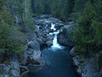 White River |
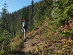 Gary On Mt. David Trail |
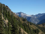 Clark Mountain |
 Ridge Top Color |
 Yellow & Red |
 David Summit In Sight |
 Whittier Peak |
 Clark Mountain Again |
 Great Lighting |
 Mt. Daniel |
 Colorful Trail Border |
 Blasted Trail |
 Color Is All Behind Us |
 Open Slope |
 Sunny In Late September |
 Amazing Color |
 Hillside Meadow |
 Gary Seeing Red |
 Clark Above David Slope |
 Great Fall Day |
 White & Red |
 And More and More... |
 Trail Section |
 Red, Yellow, & Green |
 Loose Gully Trail |
 Trail Below |
 View Northeast |
 Summit Just Above |
 Final Blasted Ledge |
 Monte Cristo Peaks |
 7 Fingered Jack & Maude |
 Glacier Peak Zoomed |
 Three Fingers |
 Daniel & Hinman |
 Indian Head Peak |
 Buck Mountain Area |
 Meadows & Whittier |
 Gary & Ig"loo" |
 I'm Taking A Break |
 Sloan Peak |
 Dirty Face Peak |
 Glacer Peak |
 Other Hiker |
 Color On Return |
 Last Color |
Trips - 2008
Home