4-13-08
It was time for a return to an old favorite. In the
past 4 or 5 years Suzanne and I have hiked up Mt. Margaret from the summer
trailhead and from the sno-park during winter. The winter trips were via
the long road walk. I had read about a more direct cross country route but
had never given it a try. Barry and his friend David joined us for this
trip. The day before the temperature reached the mid 60s at Snoqualmie
Pass. We wanted a trip with low avalanche danger. The clouds were due to
come in this day so going a little farther east made sense.
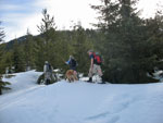
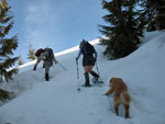
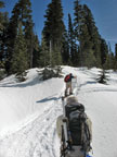
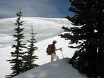
We met at the Gold Creek trailhead at 8:30. A group of four left about 15 minutes ahead of us. They were half skiing and half snowshoeing. A single snowshoer also left ahead of us. There were no snowmobile trailers there yet. Althouth it was above freezing the road was hard enough to walk in boots. Before long we reached the bridge over Rocky Run. The route up begins here. We had a short debate whether to follow the road or go cross country. Off road won out.
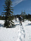
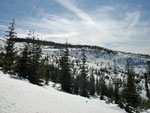
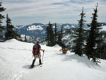
The snow was still fairly firm but we chose to put on snowshoes here. We knew we had to stay between Rocky Run on our left and Wolfe Creek on our right. The going was not bad at all. There were a few steeper sections but we had good grip on the snow and worked our way up. The trees are not so closely spaced in the clear cut areas to be much of a problem. It was nothing like North Mountain.
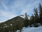
We knew that at some point we needed to head a little to our right to avoid the very steep terrain right beneath the summit. For the most part our route was pretty much straight up. There are several old roads that are crossed. These old logging spurs are in clear cuts and we stopped on them to admire the views that were opening up. Much of the way we followed some old ski tracks. Higher up there were some snowmobile tracks too.
The sun began to soften the snow and we sank a little. It still was pretty firm even in the clear cuts. Suzanne and I began to recognize the terrain from our trips up the road. We angled a little more to the right and reached the final old road. Straight up a snowmobile track and we were back in the forest. After about 2500' of gain we reached the ridge top at roughly 5100'.
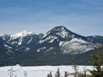
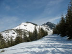
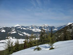
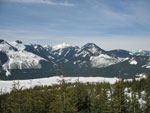
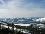
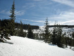
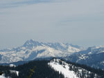
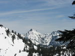
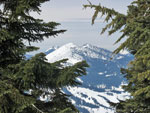
We could see Mt. Stuart in the distance and some of the many lakes below. We found a nice viewpoint for a food and water break. From here the route is along the ridge to the false summit, across the top, down to a saddle, then steeply up to the summit. There was far more snow than we had seen on any other winter trip so we were a little concerned about the route over the false summit. The snow was also getting soft in the sun. We were still fine in the shaded forest.
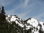
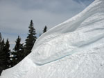
It did not take long to run the ridge to the false summit. We climbed up to within about 30 veritical feet of the summit and found a problem. The snow covered summit we had seen on past trips was now a huge cornice. Below it was a gully. We could hear the sound of water melting and running off the cornice. On the other side of the gully was a wall of snow. It might be possible to hack steps in the wall but it required standing in the gully beneath the cornice. I'd had enough.
We stopped in the open below the false summit with very nice views. Barry took a look at the other side of the gully and found a way up the other side but the snow was rapidly softening and we were concerned about coming back down later if we chose to go on. The concensus was to leave the summit for another day. Clouds were beginning to come in but it was still mostly sunny and warm.
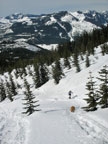
After lunch we headed down. A short ways down we met two snowshoers. They were half of the quartet that left ahead of us. They took the road route. Our route was steeper but much shorter. Our time up was about 40 minutes faster than theirs even though they were able to hike the road without snowshoes. We left the ridge earlier than we reched it and went straight down. The snow was noticeably softer than only an hour earlier.
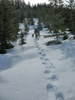
We picked up our track again before leaving the forest. When we were back in the clear cut the snow was much softer. Even with snowshoes I was plunge stepping 6 inches with each step. At times I was skiing on my snowshoes as there was no hard snow to bite into. In some ways it was harder than the climb. We went to far right below one spur road and had to cross a steep loose slope to get back on track. Barry and Suzanne did cross but David and I chose to climb back up the slope to get back on track. The snow was so loose we had to kick steps face in with snowshsoes to get down.
After that it was much better. Back in forest it was firm enough to get some grip again. We came out a little farther up the road than we left it. The last half mile or so of road seemed much larger than on the way in. A group of snowmobiles passed us near the end. They were the only snowmobiles we saw all day. I like the short cut route. It's not overly steep and it is much shorter. No snowmobile noise and exhaust smoke to breathe and some great views as well.
We did not summit but came really close. As close as I cared to push it with such soft loose snow and one big cornice. It was Barry and David's first time on Mt. Margaret and they seemed to have a good time. Suzanne and I have seen the summit a number of times and will undoubtably do so again. Clouds did come in by the end and we even had some rain on the drive home. We went just far enough east to have a beautiful day.
Suzanne's trip report is here: Nwhikers Report & Photos
Click on thumbnails to get larger pictures.
Trips - 2008
Home
We met at the Gold Creek trailhead at 8:30. A group of four left about 15 minutes ahead of us. They were half skiing and half snowshoeing. A single snowshoer also left ahead of us. There were no snowmobile trailers there yet. Althouth it was above freezing the road was hard enough to walk in boots. Before long we reached the bridge over Rocky Run. The route up begins here. We had a short debate whether to follow the road or go cross country. Off road won out.
The snow was still fairly firm but we chose to put on snowshoes here. We knew we had to stay between Rocky Run on our left and Wolfe Creek on our right. The going was not bad at all. There were a few steeper sections but we had good grip on the snow and worked our way up. The trees are not so closely spaced in the clear cut areas to be much of a problem. It was nothing like North Mountain.
We knew that at some point we needed to head a little to our right to avoid the very steep terrain right beneath the summit. For the most part our route was pretty much straight up. There are several old roads that are crossed. These old logging spurs are in clear cuts and we stopped on them to admire the views that were opening up. Much of the way we followed some old ski tracks. Higher up there were some snowmobile tracks too.
The sun began to soften the snow and we sank a little. It still was pretty firm even in the clear cuts. Suzanne and I began to recognize the terrain from our trips up the road. We angled a little more to the right and reached the final old road. Straight up a snowmobile track and we were back in the forest. After about 2500' of gain we reached the ridge top at roughly 5100'.
We could see Mt. Stuart in the distance and some of the many lakes below. We found a nice viewpoint for a food and water break. From here the route is along the ridge to the false summit, across the top, down to a saddle, then steeply up to the summit. There was far more snow than we had seen on any other winter trip so we were a little concerned about the route over the false summit. The snow was also getting soft in the sun. We were still fine in the shaded forest.
It did not take long to run the ridge to the false summit. We climbed up to within about 30 veritical feet of the summit and found a problem. The snow covered summit we had seen on past trips was now a huge cornice. Below it was a gully. We could hear the sound of water melting and running off the cornice. On the other side of the gully was a wall of snow. It might be possible to hack steps in the wall but it required standing in the gully beneath the cornice. I'd had enough.
We stopped in the open below the false summit with very nice views. Barry took a look at the other side of the gully and found a way up the other side but the snow was rapidly softening and we were concerned about coming back down later if we chose to go on. The concensus was to leave the summit for another day. Clouds were beginning to come in but it was still mostly sunny and warm.
After lunch we headed down. A short ways down we met two snowshoers. They were half of the quartet that left ahead of us. They took the road route. Our route was steeper but much shorter. Our time up was about 40 minutes faster than theirs even though they were able to hike the road without snowshoes. We left the ridge earlier than we reched it and went straight down. The snow was noticeably softer than only an hour earlier.
We picked up our track again before leaving the forest. When we were back in the clear cut the snow was much softer. Even with snowshoes I was plunge stepping 6 inches with each step. At times I was skiing on my snowshoes as there was no hard snow to bite into. In some ways it was harder than the climb. We went to far right below one spur road and had to cross a steep loose slope to get back on track. Barry and Suzanne did cross but David and I chose to climb back up the slope to get back on track. The snow was so loose we had to kick steps face in with snowshsoes to get down.
After that it was much better. Back in forest it was firm enough to get some grip again. We came out a little farther up the road than we left it. The last half mile or so of road seemed much larger than on the way in. A group of snowmobiles passed us near the end. They were the only snowmobiles we saw all day. I like the short cut route. It's not overly steep and it is much shorter. No snowmobile noise and exhaust smoke to breathe and some great views as well.
We did not summit but came really close. As close as I cared to push it with such soft loose snow and one big cornice. It was Barry and David's first time on Mt. Margaret and they seemed to have a good time. Suzanne and I have seen the summit a number of times and will undoubtably do so again. Clouds did come in by the end and we even had some rain on the drive home. We went just far enough east to have a beautiful day.
Suzanne's trip report is here: Nwhikers Report & Photos
Heading Off Road |
View Out |
Snowshoe Tracks |
Silver & Catherine |
A Little Steepr |
Crossing Old Road |
Granite Mountain |
Lake Keechelus |
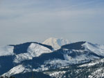
Mt. Rainier |
Granite Zoom |
Clear Cut Sunshine |
View Southwest |
Nearing Summer Route |
Ridge In Sight |
Snowmobile Tracks |
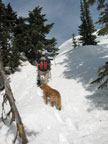
Suzanne & Gusto |
Mt. Stuart |
Hibox Mountain |
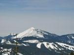
Mt. Margaret |
Near False Summit |
False Summit |
Cornice |
Granite Mountain Framed |
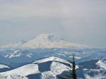
Mt. Rainier Again |
Heading Down |
Trips - 2008
Home