10-05-08
I had a chance
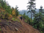
to preview a brand new trail on Sunday. It will be pretty popular when
it officially opens. About 9 miles round trip with 2300' of gain to a
peak with nice views. At least I'm pretty sure the views are great
though we had clouds all around us. The grade is very steady all the
way with about 500' of gain per mile. That is just fine for older and
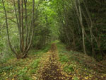
younger hikers. The first 1 1/2 miles is on an old road. The first half
mile is recently open road and a bit rocky. The next mile has been
closed for some time and has become mostly dirt and grass tread. The
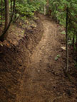
last 3 miles are new trail.
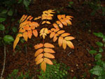
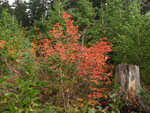
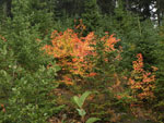
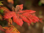
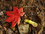
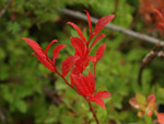
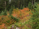
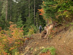
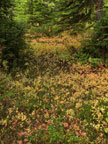
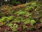
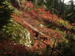
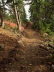
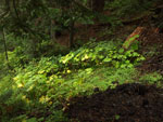
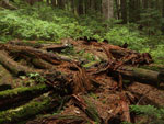
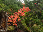
Kim and I took our time on this route. The old road section has a fair bit of fall color, especially at the end at an old logging landing. Should be some good views out to peaks as well. The new trail is all in older forest. Lots of snags, moss, and darkness but not a lot of underbrush. The grade is both very gentle and very soft. Only near the top did we find any rocky areas and there are virtually no roots. Most of the old logs are mostly decomposed. The forest should be as much a draw as the summit.
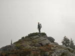
After the deluge the day before we had pretty good weather. It did drizzle a few times and even snowed a little but not for long. With many photo opportunities we took 2 1/2 hours to reach the top. At a steady pace it would have been much less. On the summit we went from zero visibility to breaks that allowed views to nearby peaks. The views did not last long though. I'll need to return after the opening to see the vistas.
On the way down Kim noticed some steps leading off trail. Inspection showed the remains of an old cabin. It is a strange place to see one. Last year we were the first to hike the new Circle Peak Trail. Now this one. It's nice to see a few new routes being built in these times of limited Forest Service budgets. I'm not a big fan of many of the features of what I consider "over building" on new trails but this one gets a sterling rating from me. I will probably get up the route at least once a year for many years to come. In the mean time there is no trailhead, no parking, and no facilities. I won't be giving out any info until the trail is officially open.
Well, it's now September 17, 2011 and the trail to Beckler Peak is officially open. I've been up it four times so far. This will be a very popular trail in a few years when word gets around. Go now before the crowds find it. Drive Highway 2 east to about a mile or so east of the Skykomish Ranger Station. Road 6066 is signed. Turn left and follow the dirt road some 6 or so miles to the end and the trailhead. Gentle trail is suitable for most hikers even with the 2300' of gain. Great views from the summit. One of very few trails on Highway 2 that leads to a summit. I believe I have the right number for the road. It is composed of three 6s and one zero.
Click on thumbnails to get larger pictures.
Trips - 2008
Home
Kim and I took our time on this route. The old road section has a fair bit of fall color, especially at the end at an old logging landing. Should be some good views out to peaks as well. The new trail is all in older forest. Lots of snags, moss, and darkness but not a lot of underbrush. The grade is both very gentle and very soft. Only near the top did we find any rocky areas and there are virtually no roots. Most of the old logs are mostly decomposed. The forest should be as much a draw as the summit.
After the deluge the day before we had pretty good weather. It did drizzle a few times and even snowed a little but not for long. With many photo opportunities we took 2 1/2 hours to reach the top. At a steady pace it would have been much less. On the summit we went from zero visibility to breaks that allowed views to nearby peaks. The views did not last long though. I'll need to return after the opening to see the vistas.
On the way down Kim noticed some steps leading off trail. Inspection showed the remains of an old cabin. It is a strange place to see one. Last year we were the first to hike the new Circle Peak Trail. Now this one. It's nice to see a few new routes being built in these times of limited Forest Service budgets. I'm not a big fan of many of the features of what I consider "over building" on new trails but this one gets a sterling rating from me. I will probably get up the route at least once a year for many years to come. In the mean time there is no trailhead, no parking, and no facilities. I won't be giving out any info until the trail is officially open.
Well, it's now September 17, 2011 and the trail to Beckler Peak is officially open. I've been up it four times so far. This will be a very popular trail in a few years when word gets around. Go now before the crowds find it. Drive Highway 2 east to about a mile or so east of the Skykomish Ranger Station. Road 6066 is signed. Turn left and follow the dirt road some 6 or so miles to the end and the trailhead. Gentle trail is suitable for most hikers even with the 2300' of gain. Great views from the summit. One of very few trails on Highway 2 that leads to a summit. I believe I have the right number for the road. It is composed of three 6s and one zero.
 First Color |
 At Logging Landing |
 Orange and Yellow |
 Single Leaf |
 Red & Green |
 Red But No Berries |
 Evergreens & Color |
 Onto New Trail |
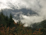 Clouds All Around |
 No Footprints Yet |
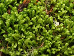 Close Up Moss |
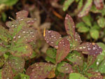 Droplets On Leaves |
 Forest Opens |
 Ferns & Color |
 Blazing Slope |
 Smooth Soft Tread |
 Kim On Summit |
 View Through Clouds |
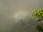 Brochen Spectre |
 Happy Hiker |
 Devils Club |
 Remains Of Cabin |
 Back To Landing |
 Low Clouds |
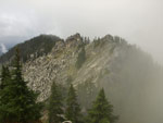
 Cathedral |
Trips - 2008
Home