3-30-08
Suzanne and Bob were out of town so we cobbled together
a group of Kolleen, Barry, David, David (Opus), plus Joanna and two
of her dogs. Late in the week we had a little snow in the lowlands and up
to a foot and a half in the mountains. The snow was much heavier near Snoqualmie
Pass than farther north. With all that in mind, Opus came up with North
Mountain. There were two trip reports earlier in the winter by Justus and
Matt. I thought we had duplicated all of Matt's winter lookout hikes the
past few weeks but I forgot about this one. Matt's group found one route
to be a mess in a big clear cut so we had some info to go on.
We met at the 160th St. Park and Ride near Kirkland and headed north. Near Marysville there was a little slush on the freeway and two cars were pointing the wrong way. A tow truck was busy cleaning up the mess. Was this an omen of what was to come? Well, I think it was. As we went through Arlington a little light snow was falling. Farther east the snow began to build up on the roadway. We were only going 40 mph as the snow was an inch or two deep across the road.
Darrington is at an elevation of only about 500'. I did not expect to have a problem with snow before we left the highway. A snowplow came along in the other direction and crossed the center line. Opus had a good scare here. As we neared Darrington the snow began to lessen and the road was now plowed clear. We stopped at the Shell station and waited for Joanna. There was snow all over town but not too deep.
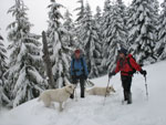
Joanna soon arrived and we headed on to the trailhead. There are two roads that can be used. The first one is about .7 miles north of the ranger station. This road goes all the way to the summit of North Mountain in some 14 miles. A little too long for us this day. The map also shows an old road that connects the first road with the second one. That one is 1.2 miles north of the ranger station. That is the road Justus took and the one we were aiming for. The road switchbacks up the south ridge of North Mountain going nearly to the top.
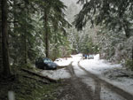
We passed the first road and missed the second one. It was snow covered. We turned around and Opus spotted it. We drove under the power lines and the road soon began to climb. After a discussion we chose to try driving higher. The road steepened and was narrow. We were concerned about finding room to turn around three vehicles. David stopped at a water bar where the road was very narrow. When he started we slid sideways. Maybe this wasn't such a good idea. We ended up backing down the snowy road to the flat bottom. We hoped to drive 500'+ up the road. We started at the level of Darrington. After wasting a whole lot of time we were ready to get going.
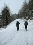
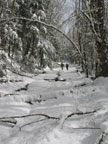
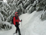
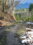
With the slow driving in snow, the wait to get together in Darrington, and our parking travails, our 7:30 meeting time ended up leading to a 9:45 starting time. Was this mountain conspiring to keep us away? At the parking spot we saw a car on it's side. Not a great omen. The road switchbacks up the slope at a fairly gentle grade. We began at 500' and had no trouble booting up the snowy road. There is one long switchback we hoped to miss by heading right up the slope. The brush was thick and heavy with lots of new wet snow. We chose not to leave the road.
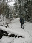
We looked for the connector road from the long road to the summit and could not find it. Even with multiple GPs units. On the way down the snow had melted enough to make finding it easy. After much easy walking we began to find downed trees. Some we could go over, some under, and some around. Many were a real pain as kneeling down in 6 inches of fresh wet snow was no fun. Some of us saw three deer then two more later. I was not out front and did not see any of them.
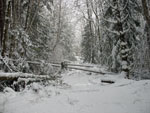
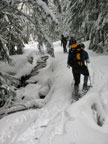
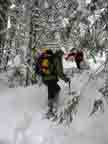
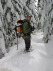
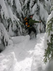
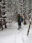
The snow continued to get deeper. At about 2000' we stopped to put on snowshoes. The road is so gentle that it took a lot of miles to gain much elevation. We knew it had to get steeper at some point. The snow was completely unconsolidated. This trip would have been much different just a few days earlier. We had more downed trees to navigate as well. Finally, at about 2900' we prepared to leave the road. After some food and water we headed up. In the trees the snow was merely deep. In open spaces it was really deep. Barry and David did most of the trailbreaking.
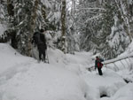
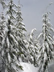
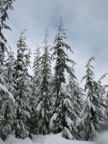
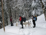
The grade was not all that steep but with the deep soft snow it made for slow going. Higher up it was now obvious we were on the ridge top. It was completely forested and the clouds allowed for no views at all. We worked our way along the ridge as the grade dropped to nearly flat. Now the real fun began. The forest of well spaced trees gave way to smaller trees packed tight together. We had to push our way through small gaps. The trees were completely flocked with wet snow soaking us as we passed.
Our pace dropped to next to nothing. Falling into tree wells or voids was a real concern. Opus was out front when he could find no way to push ahead. We turned to the right and found a small clearing. From here we tried to get back to the crest. There was one hole that was at least 10 feet deep. I could see dirt at the bottom. Falling into that hole would really be dangerous. We tried maps and GPSs and had a hard time figuring exactly where to go.
The leader worked real hard but everyone else stood around and froze. We calculated that we were .50 miles and 400' from the summit. So close but yet so far. With the difficulty of the wall of trees we might still be an hour from the top. We made the painful decision to head back. We also found that our meandering route through the trees brought us back to where we originally found a dead end. It was the shortest loop trip I have ever done.
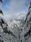
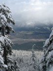
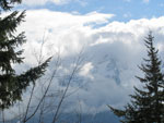
We were only a few feet from the clearing so we went back and had our only views of the trip up. Not great but we could see a little of the valley below and in the vicinity of the summit though it was still mostly in clouds. It took us 4:20 to cover about 5+ miles. It was now just after 2:00 PM. Our trench was deep and well packed. We flew back down to the road. We were back there in no time. After finishing lunch we headed down the road. The mountain ate us up and spit us out but it was not yet done. The GPSs showed some strange readings at this point. Opus's thought we were on Dirty Harry's Road near Snoqualmie Pass. David's was just off a little. Kolleen's took the cake as it showed us in Wyoming. Just what is really up in that lookout? It sure messed up our electronics.
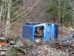
The trip down was mostly uneventful. The downed trees were still a pain but seemed less onerous than on the way up. Lower down there was a lot of snow melt. The last mile of so was bare road. It was overcast most of the day and it even snowed some. I was surprised to see so much melting. We found another car in many parts below the road. We even passed a stove. After about half the time it took to ascend we reached the cars.
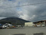
This was an interesting trip. It had very low avalanche danger on a day with much new snow in the mountains. The route finding was pretty straight forward. The amount of new snow was very surprising. I think we made the most of a marginal day. It was a fun group. I enjoyed hiking with David for the first time. As we sped through Darrington we were able to look north and see North Mountain for the first and only time this day. Statistics for the day were about 10+ miles with 3000' of elevation gain.
Opus has posted his report at: NWHikers Report And Photos
Click on thumbnails to get larger pictures.
Trips - 2008
Home
We met at the 160th St. Park and Ride near Kirkland and headed north. Near Marysville there was a little slush on the freeway and two cars were pointing the wrong way. A tow truck was busy cleaning up the mess. Was this an omen of what was to come? Well, I think it was. As we went through Arlington a little light snow was falling. Farther east the snow began to build up on the roadway. We were only going 40 mph as the snow was an inch or two deep across the road.
Darrington is at an elevation of only about 500'. I did not expect to have a problem with snow before we left the highway. A snowplow came along in the other direction and crossed the center line. Opus had a good scare here. As we neared Darrington the snow began to lessen and the road was now plowed clear. We stopped at the Shell station and waited for Joanna. There was snow all over town but not too deep.
Joanna soon arrived and we headed on to the trailhead. There are two roads that can be used. The first one is about .7 miles north of the ranger station. This road goes all the way to the summit of North Mountain in some 14 miles. A little too long for us this day. The map also shows an old road that connects the first road with the second one. That one is 1.2 miles north of the ranger station. That is the road Justus took and the one we were aiming for. The road switchbacks up the south ridge of North Mountain going nearly to the top.
We passed the first road and missed the second one. It was snow covered. We turned around and Opus spotted it. We drove under the power lines and the road soon began to climb. After a discussion we chose to try driving higher. The road steepened and was narrow. We were concerned about finding room to turn around three vehicles. David stopped at a water bar where the road was very narrow. When he started we slid sideways. Maybe this wasn't such a good idea. We ended up backing down the snowy road to the flat bottom. We hoped to drive 500'+ up the road. We started at the level of Darrington. After wasting a whole lot of time we were ready to get going.
With the slow driving in snow, the wait to get together in Darrington, and our parking travails, our 7:30 meeting time ended up leading to a 9:45 starting time. Was this mountain conspiring to keep us away? At the parking spot we saw a car on it's side. Not a great omen. The road switchbacks up the slope at a fairly gentle grade. We began at 500' and had no trouble booting up the snowy road. There is one long switchback we hoped to miss by heading right up the slope. The brush was thick and heavy with lots of new wet snow. We chose not to leave the road.
We looked for the connector road from the long road to the summit and could not find it. Even with multiple GPs units. On the way down the snow had melted enough to make finding it easy. After much easy walking we began to find downed trees. Some we could go over, some under, and some around. Many were a real pain as kneeling down in 6 inches of fresh wet snow was no fun. Some of us saw three deer then two more later. I was not out front and did not see any of them.
The snow continued to get deeper. At about 2000' we stopped to put on snowshoes. The road is so gentle that it took a lot of miles to gain much elevation. We knew it had to get steeper at some point. The snow was completely unconsolidated. This trip would have been much different just a few days earlier. We had more downed trees to navigate as well. Finally, at about 2900' we prepared to leave the road. After some food and water we headed up. In the trees the snow was merely deep. In open spaces it was really deep. Barry and David did most of the trailbreaking.
The grade was not all that steep but with the deep soft snow it made for slow going. Higher up it was now obvious we were on the ridge top. It was completely forested and the clouds allowed for no views at all. We worked our way along the ridge as the grade dropped to nearly flat. Now the real fun began. The forest of well spaced trees gave way to smaller trees packed tight together. We had to push our way through small gaps. The trees were completely flocked with wet snow soaking us as we passed.
Our pace dropped to next to nothing. Falling into tree wells or voids was a real concern. Opus was out front when he could find no way to push ahead. We turned to the right and found a small clearing. From here we tried to get back to the crest. There was one hole that was at least 10 feet deep. I could see dirt at the bottom. Falling into that hole would really be dangerous. We tried maps and GPSs and had a hard time figuring exactly where to go.
The leader worked real hard but everyone else stood around and froze. We calculated that we were .50 miles and 400' from the summit. So close but yet so far. With the difficulty of the wall of trees we might still be an hour from the top. We made the painful decision to head back. We also found that our meandering route through the trees brought us back to where we originally found a dead end. It was the shortest loop trip I have ever done.
We were only a few feet from the clearing so we went back and had our only views of the trip up. Not great but we could see a little of the valley below and in the vicinity of the summit though it was still mostly in clouds. It took us 4:20 to cover about 5+ miles. It was now just after 2:00 PM. Our trench was deep and well packed. We flew back down to the road. We were back there in no time. After finishing lunch we headed down the road. The mountain ate us up and spit us out but it was not yet done. The GPSs showed some strange readings at this point. Opus's thought we were on Dirty Harry's Road near Snoqualmie Pass. David's was just off a little. Kolleen's took the cake as it showed us in Wyoming. Just what is really up in that lookout? It sure messed up our electronics.
The trip down was mostly uneventful. The downed trees were still a pain but seemed less onerous than on the way up. Lower down there was a lot of snow melt. The last mile of so was bare road. It was overcast most of the day and it even snowed some. I was surprised to see so much melting. We found another car in many parts below the road. We even passed a stove. After about half the time it took to ascend we reached the cars.
This was an interesting trip. It had very low avalanche danger on a day with much new snow in the mountains. The route finding was pretty straight forward. The amount of new snow was very surprising. I think we made the most of a marginal day. It was a fun group. I enjoyed hiking with David for the first time. As we sped through Darrington we were able to look north and see North Mountain for the first and only time this day. Statistics for the day were about 10+ miles with 3000' of elevation gain.
Opus has posted his report at: NWHikers Report And Photos
Parking Spot |
A Little Snow To Start |
Getting Deeper |
Downed Trees |
Flocked Trees |
Snowshoes On |
This Is The Road? |
Trench Deep |
Kolleen |
Opus |
A Little View |
View To Summit? |
Joanna & Kollen |
Wall Of Trees |
Best View |
Wall Of Trees |
Easier Walking |
Back On The Road |

Small Trees Down |
Mossy Log |
Seatbelt Plant |
Whitehorse Mt. |
Melting Fast |
Previous Hikers? |
North Mountain |
Trips - 2008
Home