11-30-08
Kim had a hike in mind and it was one I had never done. She and Shep
hiked up the other Squire Creek Trail from Darrington a few weeks
earlier. That route was disrupted by a huge slide during the fall of
2003. They made it far up the trail but short of the pass. The plan
this weekend was to drive up the Clear Creek Road to the Eight Mile
Trail which reaches the pass in a short 2 1/2 miles. That road was also
taken out by the floods of 2003 but is now open once again. There have
been very few trip reports on either Squire Creek Pass trail though
both routes are now open.
Kim and I met Shep at the 128th Park and Ride off I-5 north of Lynnwood at 7:40. It was very foggy in Seattle but began to lessen as we drove north. At Darrington we headed south on the Mountain Loop Highway some 3.4 miles to an obvious unsigned gravel road on the right. The Clear Creek Campground was just past the turn off. There are several repaired washouts in the first couple miles. Most cars should be able to get over them though there is still a bit of a dip.
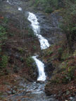
One creek crosses the road on a concrete pad. We stopped as there is a spectacular waterfall here. On down the road we came to one junction. The right hand road is correct. Within less than a mile we reached the trailhead. The road goes on but there is a wide spot here and a sign in the trees to the right. Not surprisingly, there were no other cars there. The trailhead is at about 1700'. It took us about 1:45 from the P&R to the trailhead. That's about 2:10 from North Seattle.
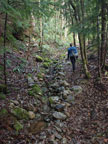
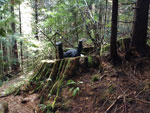
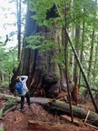
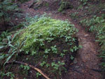
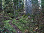
The route begins on an old road. It's rocky but easy enough walking. The route has been cleared this year. A number of recent fallen logs have been cut and removed. Shep moved out ahead and we did not see him again until the pass. Kim and I went a little slower. After the route leaves the road it climbs through logged forest. The logging was long ago and there are some good sized trees here. There are also so massive stumps. Some more than 10 feet across. There is also one of the biggest red cedars I have ever seen. It's width is more than double my height. Something over 12 feet wide at the base. That tree was worth the trip along.
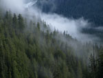
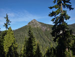
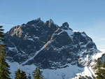
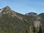
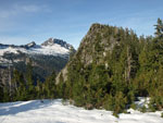
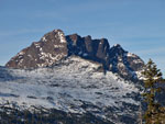
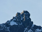
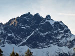
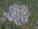
Higher up we entered the Boulder River Wilderness. The logging ended and the old growth began. Kim and I saw some huge trees on the trail to Goat Lake last weekend but these trees may be even bigger. Wow! What a place. Kim has done trail maintenance work as far as Three O'Clock Rock. We soon reached the rock. The trail goes right below it. The rock is one huge slab heading to the sky. Several hundred feet of solid rock. Very impressive from the bottom looking up.
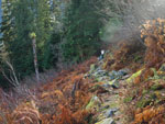
As we climbed the temperature steadily rose. I had gloves on at the bottom but was down to short sleeves by this time. It felt like spring not a few hours before December. After the rock the trail goes back into old growth forest. The trail is steep in places and gentler in others. It is smooth then rooty and rocky. It seems to be tread and bootpath mixed together. While it was wet and muddy in places it was not nearly as bad as I was led to believe.
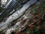
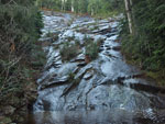
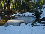
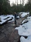
Beyond Three O'Clock Rock the trail comes to a creek that falls entirely on a slab of rock. It is at least 20 feet wide and goes as far up and down the slope as you can see. This too is worth the hike to see. I haven't seen anything like it before. At least not that big.
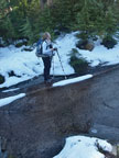
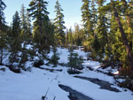
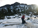
The trail switchbacks up between the creek and Three O'Clock Rock. At each leftward switchback you can see out to the the rock. The route flattens a little where it crosses the creek. Here there is a water fall into a pool and the crossing was just a two foot gap in the rocks. An easy step over. The route continues through old growth forest. We soon had some snow patches. The map showed no creek crossings on the whole route. Well at least in the fall that is far from true. I coined the term "NEC" for non existent creeks. We passes about a dozen of them.
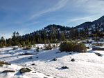
At about NEC 4 we wee on mostly solid snow. It was never more than about 6 inches deep at any point. Enough to cover the ground and bury the trail but not enough to bury my boots. We had Shep's tracks to follow where the trail was not so obvious under the snow. Higher up it was almost sub alpine though we were at less than 4000'. Smaller trees, heather, huckleberry bushes, and lots of rock slabs. Nearly all the slabs were now creeks. We crossed a lot of them. They appeared to be impossibly slick with running water and even moss. In fact, the footing was just fine. These must be dry most of the year or they would be very slick and slimy.
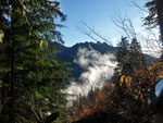
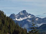
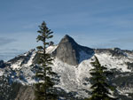
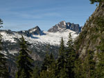
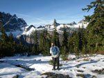
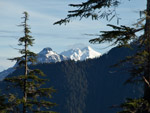
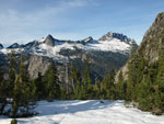
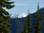
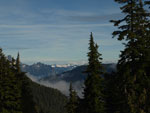
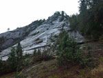
We could see the pass long before we arrived. The trail seemed to just go on and on. This is the longest 2 1/2 mile trail I have done. At long last we reached the pass at a point just south and a little higher than the 4000' low point. Shep was sitting on a rock enjoining some stunning views. Three Fingers was just across the valley. Whitehorse was to the north on that ridge. Behind us was White Chuck Mountain, Mt. Pugh, and Glacier Peak. The pass is mostly flat slabby rock and it had a few inches of snow on it. It was really getting warm now. Must have been 55 degrees with bright sunshine and not a whisper of wind. What a place.
We were in no hurry to head on down. Kim and I arrived at 12:20. We didn't leave until 2:30. To the south of the pass is a ridge. We convinced Shep to hike on up to the top to see what the view south is like. We were in the sun and most of the way up was in the shade. I just couldn't prod myself to join him. It took a while for Shep to clamber up on the thin snow. He was crossing snowy rocks higher up and falling through. He did persist and made it to the top. He has some photos at the Nwhikers link below this report. While it took him about 35 minutes to get up there he came down in 16 minutes. Just as well as the sun was gong behind the ridge and it was getting cold at the pass.
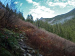
The trip down was a little slick. There were several pratt falls to be seen. We were almost to the start of the rocky road section when it became really dark. The forest was thinner there and we managed to stumble out to the car without headlamps. It was about 4:45 when we reached the trailhead. It still took 1:45 to come down this 2 1/2 mile trail. Just like Goat Lake the week before, we saw exactly zero people all day long. That's a shame. This is a great trail. It should be used more. Huge trees, amazing slab creek/waterfalls, Three O'Clock Rock, heather meadows, and terrific views from the pass. All than in 5 miles round trip with 2300' of gain. It's rooty and rocky in places but very much worth the effort.
I had a terrific time on this hike. I have planned to visit Squire Creek Pass for decades but just never got around to it. I'm glad I did. A great destination, a new trail and good company as well. Through in a spring time like day with short sleeves and crystal clear sky and you have a heck of a way to spend an almost winter day.
Kim's report is here: Nwhikers Report & Photos
Click on thumbnails to get larger pictures.
Trips - 2008
Home
Kim and I met Shep at the 128th Park and Ride off I-5 north of Lynnwood at 7:40. It was very foggy in Seattle but began to lessen as we drove north. At Darrington we headed south on the Mountain Loop Highway some 3.4 miles to an obvious unsigned gravel road on the right. The Clear Creek Campground was just past the turn off. There are several repaired washouts in the first couple miles. Most cars should be able to get over them though there is still a bit of a dip.
One creek crosses the road on a concrete pad. We stopped as there is a spectacular waterfall here. On down the road we came to one junction. The right hand road is correct. Within less than a mile we reached the trailhead. The road goes on but there is a wide spot here and a sign in the trees to the right. Not surprisingly, there were no other cars there. The trailhead is at about 1700'. It took us about 1:45 from the P&R to the trailhead. That's about 2:10 from North Seattle.
The route begins on an old road. It's rocky but easy enough walking. The route has been cleared this year. A number of recent fallen logs have been cut and removed. Shep moved out ahead and we did not see him again until the pass. Kim and I went a little slower. After the route leaves the road it climbs through logged forest. The logging was long ago and there are some good sized trees here. There are also so massive stumps. Some more than 10 feet across. There is also one of the biggest red cedars I have ever seen. It's width is more than double my height. Something over 12 feet wide at the base. That tree was worth the trip along.
Higher up we entered the Boulder River Wilderness. The logging ended and the old growth began. Kim and I saw some huge trees on the trail to Goat Lake last weekend but these trees may be even bigger. Wow! What a place. Kim has done trail maintenance work as far as Three O'Clock Rock. We soon reached the rock. The trail goes right below it. The rock is one huge slab heading to the sky. Several hundred feet of solid rock. Very impressive from the bottom looking up.
As we climbed the temperature steadily rose. I had gloves on at the bottom but was down to short sleeves by this time. It felt like spring not a few hours before December. After the rock the trail goes back into old growth forest. The trail is steep in places and gentler in others. It is smooth then rooty and rocky. It seems to be tread and bootpath mixed together. While it was wet and muddy in places it was not nearly as bad as I was led to believe.
Beyond Three O'Clock Rock the trail comes to a creek that falls entirely on a slab of rock. It is at least 20 feet wide and goes as far up and down the slope as you can see. This too is worth the hike to see. I haven't seen anything like it before. At least not that big.
The trail switchbacks up between the creek and Three O'Clock Rock. At each leftward switchback you can see out to the the rock. The route flattens a little where it crosses the creek. Here there is a water fall into a pool and the crossing was just a two foot gap in the rocks. An easy step over. The route continues through old growth forest. We soon had some snow patches. The map showed no creek crossings on the whole route. Well at least in the fall that is far from true. I coined the term "NEC" for non existent creeks. We passes about a dozen of them.
At about NEC 4 we wee on mostly solid snow. It was never more than about 6 inches deep at any point. Enough to cover the ground and bury the trail but not enough to bury my boots. We had Shep's tracks to follow where the trail was not so obvious under the snow. Higher up it was almost sub alpine though we were at less than 4000'. Smaller trees, heather, huckleberry bushes, and lots of rock slabs. Nearly all the slabs were now creeks. We crossed a lot of them. They appeared to be impossibly slick with running water and even moss. In fact, the footing was just fine. These must be dry most of the year or they would be very slick and slimy.
We could see the pass long before we arrived. The trail seemed to just go on and on. This is the longest 2 1/2 mile trail I have done. At long last we reached the pass at a point just south and a little higher than the 4000' low point. Shep was sitting on a rock enjoining some stunning views. Three Fingers was just across the valley. Whitehorse was to the north on that ridge. Behind us was White Chuck Mountain, Mt. Pugh, and Glacier Peak. The pass is mostly flat slabby rock and it had a few inches of snow on it. It was really getting warm now. Must have been 55 degrees with bright sunshine and not a whisper of wind. What a place.
We were in no hurry to head on down. Kim and I arrived at 12:20. We didn't leave until 2:30. To the south of the pass is a ridge. We convinced Shep to hike on up to the top to see what the view south is like. We were in the sun and most of the way up was in the shade. I just couldn't prod myself to join him. It took a while for Shep to clamber up on the thin snow. He was crossing snowy rocks higher up and falling through. He did persist and made it to the top. He has some photos at the Nwhikers link below this report. While it took him about 35 minutes to get up there he came down in 16 minutes. Just as well as the sun was gong behind the ridge and it was getting cold at the pass.
The trip down was a little slick. There were several pratt falls to be seen. We were almost to the start of the rocky road section when it became really dark. The forest was thinner there and we managed to stumble out to the car without headlamps. It was about 4:45 when we reached the trailhead. It still took 1:45 to come down this 2 1/2 mile trail. Just like Goat Lake the week before, we saw exactly zero people all day long. That's a shame. This is a great trail. It should be used more. Huge trees, amazing slab creek/waterfalls, Three O'Clock Rock, heather meadows, and terrific views from the pass. All than in 5 miles round trip with 2300' of gain. It's rooty and rocky in places but very much worth the effort.
I had a terrific time on this hike. I have planned to visit Squire Creek Pass for decades but just never got around to it. I'm glad I did. A great destination, a new trail and good company as well. Through in a spring time like day with short sleeves and crystal clear sky and you have a heck of a way to spend an almost winter day.
Kim's report is here: Nwhikers Report & Photos
 Waterfall Along Road |
 Old Road/Trail |
 Stump Diving |
 One Big Tree |
 Many Shades Of Green |
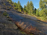
 Slide Alder Slope |
 Valley Clouds |
 Open Slope |
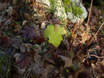 Lone Green Leaf |
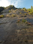 Three O"Clock Rock |
 Across The Rock |
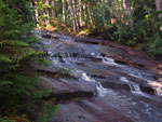 Slab Creek |
 Rising Cloud |
 Middle Of TOC Rock |
 Creek Crossing |
 Lined With Green |
 White Chuck Mountain |
 NE View |
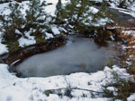 Almost Frozen |
 Kim On Creek/Slab |
 Snow Covered Trail |
 Frozen Pond |
 Three Fingers |
 Salish Peak? |
 Whitehorse |
 Kim At Squire Creek Pass |
 Pugh & Glacier Peak |
 Jumbo Mountain |
 Salish & Whitehorse |
 View Of The Pass |
 Point North Of The Pass |
 Whitehorse Close Up |
 Three Fingers Lookout |
 Lenticular Cloud |
 Clouds Over Three Fingers |
 View East |
 Packing Up |
 Shep On Slab |
 Interesting Pattern |
 Back To The Rock |
Trips - 2008
Home