6-20-09
The good weather
was to the east so back we went to the Teanaway area. Bill Peak is one
of the few Teanaway area summits nobody else had climbed. I had been up
twice on dirt and once on snow. Our crew included Bob, Kolleen, Elle,
Suzanne, and Barry. After a debate on the route we chose Beverly Creek
to Bill's Peak then Mary Peak and out via Bean Creek Basin. There were
already half a dozen cars in the lot when we arrived at 9:15 am.
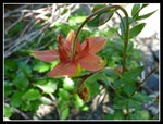
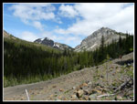
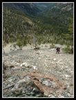
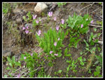
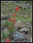
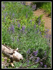
The first half mile up to Bean Creek went by fast. On my earlier backpack to Iron Peak the creek crossing was more than knee deep. The creek was a little lower now and a few logs span the creek. We all made it across with dry feet. Snow is rapidly disappearing. There is still some on Iron and Teanaway Peaks but the valley is snow free. Flowers are just beginning. I saw one yellow paintbrush and half dozen scarlet gilia. In a few weeks the paintbrush, lupine, and scarlet gilia should be more prolific.
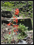
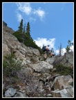
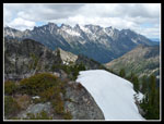
We passed a small group also heading up. One of only two groups we saw all day. On the trail up to Fourth Creek Pass more flowers appeared. The snow has not been gone long and there are still glacier lilies in bloom. I also saw shooting stars and western anemones. We took a break at the pass. From there to the summit is 1300' in about half a mile. We headed north from the pass. The slope is steep and the footing is a little loose but not all that bad. This south slope is completely snow free.
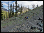
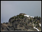
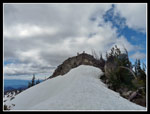
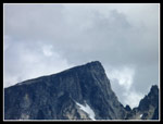
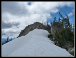
The grade lessened markedly when we reached the ridge. Snow patches began. Some we skirted and some we hiked. up. As usual, Barry, Suzanne, and Elle were soon out of sight. Bob, Kolleen, and I followed prints in the snow or just took the path of least resistance. I recalled the steep grassy gully that leads to the summit block but there were too much snow to recognize it. We ended up going farther to the right (north). Hands were useful in a few places but for the most part it was a walk up. I finally popped up on the snow covered summit ridge and saw the others on the summit. The last 10 feet were up a sloping rock to the top.
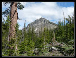
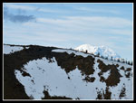
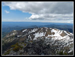
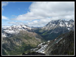
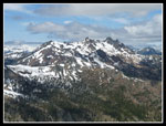
Bob and Kolleen were a few minutes behind me. The top of Mt. Stuart was now in the clouds but all the other peaks were in the clear. Even Mt. Rainier avoided the clouds. Bill's Peak is one of the best viewpoints in the Teanaway area. At 6980' it is higher than Teanaway and Iron to the west. Only Stuart is high enough to block the view. I spent a half hour on the top. It was very windy in Cle Elum on the drive over but the wind on the summit was very mild. Cold enough for a jacket but not cold enough to chase us down. I arrived at 12:15. By 12:45 we headed down.
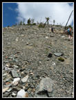
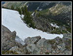
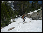
I chose to take out my ice axe for the upper snow fields. The snow was not too hard but hard enough to send you sliding into trees if you slipped. The tracks in the snow from Barry, Elle, and Suzanne went much farther down the ridge than the point where we ascended to the ridge. We started down on loose scree over hard rock. Not very good footing. I traversed back right towards where we had come up. The footing improved and we made it down to Fourth Creek Pass.
Bob's hip was hurting from the steep traversing descent. My knee was a little sore too. Bob, Kolleen, and I decided to head down via the Beverly Creek Trail which we had hiked up. The others took off on the ridge of Mary. We would just have to be content with "only" eight miles and 3300' of gain. After the very steep drop to the pass the rest of the way down was pretty easy. We had some time now to photograph flowers and peaks. I was not in a big hurry as we would have to wait in the parking lot for the others anyway.
Even at a moderate pace we reached the trailhead in about 2 1/4 hours from the summit. There were now 20 cars in the lot and a few more down the road. All those cars and we saw two groups on our trip. A number of groups returned while we waited. One group included puzzler and cartman from nwhikers. After an hour the rest of our group finished their trip. Seems they went over Mary then Judy Peaks and continued down the ridge to the Beverly Trail at the Bean Creek crossing. That had to be slower than an easy descent to Bean Creek Basin and a nice trail down from there.
On the way home we had dark clouds over the mountains at and west of the crest. It was nice to have had a pretty sunny day east of the crest. Bill's Peak is a fun scramble. Steep slope to the ridge then less steep on the upper slopes. A little route finding and a little snow travel this day. And the spectacular views. All in all, it was a very nice day for a scramble summit.
Suzanne's report is here: Nwhikers Report & Photos
Click on thumbnails to get larger pictures.
Trips - 2009
Home
The first half mile up to Bean Creek went by fast. On my earlier backpack to Iron Peak the creek crossing was more than knee deep. The creek was a little lower now and a few logs span the creek. We all made it across with dry feet. Snow is rapidly disappearing. There is still some on Iron and Teanaway Peaks but the valley is snow free. Flowers are just beginning. I saw one yellow paintbrush and half dozen scarlet gilia. In a few weeks the paintbrush, lupine, and scarlet gilia should be more prolific.
We passed a small group also heading up. One of only two groups we saw all day. On the trail up to Fourth Creek Pass more flowers appeared. The snow has not been gone long and there are still glacier lilies in bloom. I also saw shooting stars and western anemones. We took a break at the pass. From there to the summit is 1300' in about half a mile. We headed north from the pass. The slope is steep and the footing is a little loose but not all that bad. This south slope is completely snow free.
The grade lessened markedly when we reached the ridge. Snow patches began. Some we skirted and some we hiked. up. As usual, Barry, Suzanne, and Elle were soon out of sight. Bob, Kolleen, and I followed prints in the snow or just took the path of least resistance. I recalled the steep grassy gully that leads to the summit block but there were too much snow to recognize it. We ended up going farther to the right (north). Hands were useful in a few places but for the most part it was a walk up. I finally popped up on the snow covered summit ridge and saw the others on the summit. The last 10 feet were up a sloping rock to the top.
Bob and Kolleen were a few minutes behind me. The top of Mt. Stuart was now in the clouds but all the other peaks were in the clear. Even Mt. Rainier avoided the clouds. Bill's Peak is one of the best viewpoints in the Teanaway area. At 6980' it is higher than Teanaway and Iron to the west. Only Stuart is high enough to block the view. I spent a half hour on the top. It was very windy in Cle Elum on the drive over but the wind on the summit was very mild. Cold enough for a jacket but not cold enough to chase us down. I arrived at 12:15. By 12:45 we headed down.
I chose to take out my ice axe for the upper snow fields. The snow was not too hard but hard enough to send you sliding into trees if you slipped. The tracks in the snow from Barry, Elle, and Suzanne went much farther down the ridge than the point where we ascended to the ridge. We started down on loose scree over hard rock. Not very good footing. I traversed back right towards where we had come up. The footing improved and we made it down to Fourth Creek Pass.
Bob's hip was hurting from the steep traversing descent. My knee was a little sore too. Bob, Kolleen, and I decided to head down via the Beverly Creek Trail which we had hiked up. The others took off on the ridge of Mary. We would just have to be content with "only" eight miles and 3300' of gain. After the very steep drop to the pass the rest of the way down was pretty easy. We had some time now to photograph flowers and peaks. I was not in a big hurry as we would have to wait in the parking lot for the others anyway.
Even at a moderate pace we reached the trailhead in about 2 1/4 hours from the summit. There were now 20 cars in the lot and a few more down the road. All those cars and we saw two groups on our trip. A number of groups returned while we waited. One group included puzzler and cartman from nwhikers. After an hour the rest of our group finished their trip. Seems they went over Mary then Judy Peaks and continued down the ridge to the Beverly Trail at the Bean Creek crossing. That had to be slower than an easy descent to Bean Creek Basin and a nice trail down from there.
On the way home we had dark clouds over the mountains at and west of the crest. It was nice to have had a pretty sunny day east of the crest. Bill's Peak is a fun scramble. Steep slope to the ridge then less steep on the upper slopes. A little route finding and a little snow travel this day. And the spectacular views. All in all, it was a very nice day for a scramble summit.
Suzanne's report is here: Nwhikers Report & Photos
 Columbine |
 Scarlet Gilia |
 First View Of Bill's Peak |
 Open Slopes & Bill's |
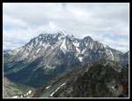
 Teanaway & Bill's Peaks |
 Zoomed Bill's Summit |
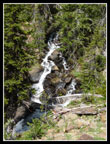 Beverly Creek |
 Colorful Flower |
 Climbing Steep Slope |
 Looking Down |
 Volcanic Neck |
 Snow Patch |
 Iron Peak |
 Mt. Rainier Over Iron |
 Scrambling Up |
 Bill's Summit |
 Mt. Stuart In Clouds |
 Fortune & Ingalls |
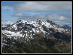
 Mary & Earl Peaks |
 Teanaway Peak |
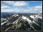
 Iron Peak & Ridge |
 Little Annapurna |
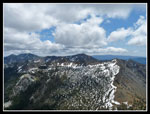
 Stuart Range |
 Gully Route |
 Ingalls & Stuart |
 View West |
 Descending Summit Block |
 Suzanne Descending |
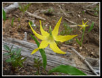 Glacier Lily |
 Shooting Stars |
 More Color |
 Another Gilia |
 Bob & Kolleen |
 Lupine |
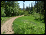 Grassy Trail |
Trips - 2009
Home