4-10-09
Good Friday is a
holiday in my
business and I usually get out for a hike. I wanted to keep the drive
short as my car is finally running again and I want to get my
confidence back before a long trip. I couldn't come up with anything
close by that I
had not done in the past few years. With clouds and rain over most of
the mountains I figured a lake would be better than a summit
with
no views. Calligan Lake up the North Fork Snoqualmie River fit the bill.
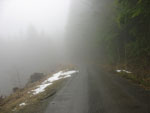
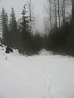
It was rainy and misty on the drive out. I passed through North Bend and headed out along the North Fork. At the end of pavement I found a road grader right in front of me. He was blocking the road and moving at a very slow pace. It took a few minutes but he finally saw me and pulled over. I squeezed by and found that there was a 6-8 inch high line of dirt all the way down the road. It made the lanes narrow. I had to ride up onto the pile to avoid a few rocks. Most pot holes had been filled in. On my way out the grading was finished. The road is in unusually good shape at least for the near term.
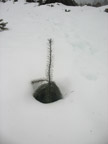
Four miles of dirt brought me to the 1000' Spur 10 gates. I was the only car parked there. It was the only time I have seen all the gates open. I headed out into a light mist. A truck passed me coming out and he spooked a deer. That was the only animal encounter I had. I passed a large amount of rock off the side of the road. It looks like another supply of rocks for landscaping. I crossed the bridge over the river at about 1 1/4 miles. At the four way junction I went straight ahead uphill.
The road climbs from here to near the turn off to Calligan Lake. Following the road takes you to Hancock Lake. It has quite a few cabins along the shore. Calligan has none. The map shows that the road turns to the right and the Calligan spur goes off straight ahead. I came to such a place and the road ahead looked small. I took it and it immediately ended. Okay, I kept going on the main road. I came to another road and took it. In about 1/4 mile it ended in a clear cut. Strike two. Just a few minutes down the main road I came to another junction. This one I vaguely recognized. It is a three way "Y" with a small forested island in the middle.
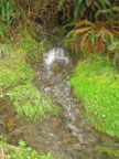
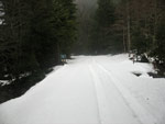
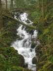
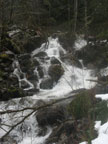
I angled off to the left on that road. The junction is at about 1800'. The next 1 3/4 miles is slightly downhill. I saw only a few small snow patches off the road so far but as I descended snow suddenly appeared. It was quickly 4-6 inches deep but not deep enough to need snowshoes. I came to Calligan Creek and found that it passes under the road in two places. One has a sign and the other one was bigger. There is a nice waterfall just up the creek.
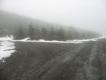
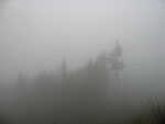
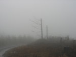
A few minutes past the creek the snow ended and I came to another junction at 1700'. I turned right and began to climb again. I came to another gate and it too was open. A truck with a load of firewood passed me heading out. The road left forest and entered another clear cut. Might be good views here but I could only see the clouds and mist. With the limited visibility it didn't seem like I was in a tree farm close to the city.
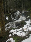
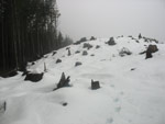
At about 2000' snow again was on the road. At a sign denoting 5 miles I reached another junction. Uphill left and flat to the right. I went right. The sound of Calligan Creek grew and the snow depth increased. I thought I was near the lake but finally broke down and put on snowshoes. The road kept on going and going... Where in the heck was the lake? I came to a 5 1/2 mile marker and still it went on. One more intersection appeared. Uphill into a clear cut or a slight drop in forest. I went right and down. Very quickly the road turned into a mine field. Downed trees and brush showed this road has not been used in some time.
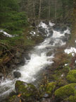
I started to posthole deeply while meandering around the obstacles. The creek was now just to my right. This was way too difficult and I decided to head uphill into the clear cut. A short climb brought me up to a big plateau of stumps and logging debris. That was much easier to traverse than the road below. A few minutes walking through the clear cut and I could see the snow covered lake below through a thin wall of trees.
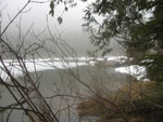
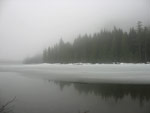
I dropped down and snowshoed over downed logs and through brush to the lake shore. Low clouds hung over the lake and most of it was still frozen. I was not far from the outlet. The loggers left about a 50' buffer of trees along the lake shore. I was wet and cold but it was time to sit down for lunch. On my last visit I followed the road to the lake and sat down looking at clear cuts down the lake. Now the clear cuts are near the outlet. After my break it was time to head on back.
The trip back was non eventful. The rain/mist never did stop entirely. As long as I kept moving I was warm enough. As expected I did not see any other people though I did see the two small trucks while coming in and two more big ones coming out. Back at Spur 10 all the gates were closed and one car was parked near the start of the Fuller Mountain route. I still need to do that hike some day.
It was a surprisingly good day for a hike. Damp all day but never hard rain. Enough snow to make snowshoes useful near the lake but most of the route was fine with just boots. The mist made for an eerie mood that made it seem like I was farther into the backcountry than I was. Calligan is not a pretty lake but it does provide solitude and a nice long workout. The lake is at only 2222' but there was plenty of snow even in early April. All in all, a good weekday to get out of town.
Click on thumbnails to get larger pictures.
Trips - 2009
Home
It was rainy and misty on the drive out. I passed through North Bend and headed out along the North Fork. At the end of pavement I found a road grader right in front of me. He was blocking the road and moving at a very slow pace. It took a few minutes but he finally saw me and pulled over. I squeezed by and found that there was a 6-8 inch high line of dirt all the way down the road. It made the lanes narrow. I had to ride up onto the pile to avoid a few rocks. Most pot holes had been filled in. On my way out the grading was finished. The road is in unusually good shape at least for the near term.
Four miles of dirt brought me to the 1000' Spur 10 gates. I was the only car parked there. It was the only time I have seen all the gates open. I headed out into a light mist. A truck passed me coming out and he spooked a deer. That was the only animal encounter I had. I passed a large amount of rock off the side of the road. It looks like another supply of rocks for landscaping. I crossed the bridge over the river at about 1 1/4 miles. At the four way junction I went straight ahead uphill.
The road climbs from here to near the turn off to Calligan Lake. Following the road takes you to Hancock Lake. It has quite a few cabins along the shore. Calligan has none. The map shows that the road turns to the right and the Calligan spur goes off straight ahead. I came to such a place and the road ahead looked small. I took it and it immediately ended. Okay, I kept going on the main road. I came to another road and took it. In about 1/4 mile it ended in a clear cut. Strike two. Just a few minutes down the main road I came to another junction. This one I vaguely recognized. It is a three way "Y" with a small forested island in the middle.
I angled off to the left on that road. The junction is at about 1800'. The next 1 3/4 miles is slightly downhill. I saw only a few small snow patches off the road so far but as I descended snow suddenly appeared. It was quickly 4-6 inches deep but not deep enough to need snowshoes. I came to Calligan Creek and found that it passes under the road in two places. One has a sign and the other one was bigger. There is a nice waterfall just up the creek.
A few minutes past the creek the snow ended and I came to another junction at 1700'. I turned right and began to climb again. I came to another gate and it too was open. A truck with a load of firewood passed me heading out. The road left forest and entered another clear cut. Might be good views here but I could only see the clouds and mist. With the limited visibility it didn't seem like I was in a tree farm close to the city.
At about 2000' snow again was on the road. At a sign denoting 5 miles I reached another junction. Uphill left and flat to the right. I went right. The sound of Calligan Creek grew and the snow depth increased. I thought I was near the lake but finally broke down and put on snowshoes. The road kept on going and going... Where in the heck was the lake? I came to a 5 1/2 mile marker and still it went on. One more intersection appeared. Uphill into a clear cut or a slight drop in forest. I went right and down. Very quickly the road turned into a mine field. Downed trees and brush showed this road has not been used in some time.
I started to posthole deeply while meandering around the obstacles. The creek was now just to my right. This was way too difficult and I decided to head uphill into the clear cut. A short climb brought me up to a big plateau of stumps and logging debris. That was much easier to traverse than the road below. A few minutes walking through the clear cut and I could see the snow covered lake below through a thin wall of trees.
I dropped down and snowshoed over downed logs and through brush to the lake shore. Low clouds hung over the lake and most of it was still frozen. I was not far from the outlet. The loggers left about a 50' buffer of trees along the lake shore. I was wet and cold but it was time to sit down for lunch. On my last visit I followed the road to the lake and sat down looking at clear cuts down the lake. Now the clear cuts are near the outlet. After my break it was time to head on back.
The trip back was non eventful. The rain/mist never did stop entirely. As long as I kept moving I was warm enough. As expected I did not see any other people though I did see the two small trucks while coming in and two more big ones coming out. Back at Spur 10 all the gates were closed and one car was parked near the start of the Fuller Mountain route. I still need to do that hike some day.
It was a surprisingly good day for a hike. Damp all day but never hard rain. Enough snow to make snowshoes useful near the lake but most of the route was fine with just boots. The mist made for an eerie mood that made it seem like I was farther into the backcountry than I was. Calligan is not a pretty lake but it does provide solitude and a nice long workout. The lake is at only 2222' but there was plenty of snow even in early April. All in all, a good weekday to get out of town.
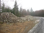 Rock Pile Along Road |
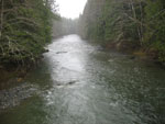 NF Snoqualmie River |
 Nearly The Only Color |
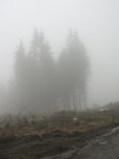 Getting Very Gray |
 First Snow |
 Solid Snow At Bridge |
 Waterfall From Bridge |
 Cascades |
 Another Falls |
 Calligan Outlet |
 Clouds Over Calligan Lake |
 Clear Cut Next To Lake |
 Not Waiting For Spring |
 Overgrown Road |
 5 Mile Junction |
 Even Cloudier |
 Two Lone Snags |
 One More Falls |
 One Skunk Cabbage |
 Strange Little Bump |
Trips - 2009
Home