5-23-09
Where to go on
Memorial Day weekend? Sunny weather for all three days? That never
happens. Kim and I chose to head north and east to the Methow Valley.
We let the crowds jam the highways on Friday and headed out at 6:00 am
on Saturday. Traffic was not bad at all. We cruised over the North
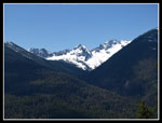
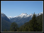
Cascades Highway and down into the Methow Valley. Still lots of snow
near Washington Pass making for some great views. We decided to go for
Driveway Butte that day. The trailhead is next to Klipchuck
campgrounds. It's 12.6 miles east of Washington Pass.
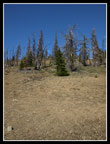
There were still two open campsites but we chose to take our chances up the Chewuch River as we planned to hike up there too. It was already 10:50 and getting warm when we started up the trail. Kim had done the trail once before without snow and with trees. A fire burned up the second half of the route. It would be interesting for her to compare forest to burn. The maps show this trail being 4 miles each way. They also show the trail going straight up with on switchback to the right. I believe some rerouting has lengthened the trail. There are now several switchbacks. One is very long.
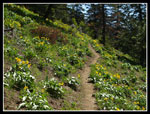
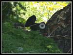
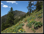
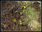
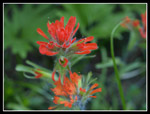
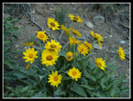
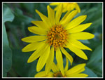
The flower show was excellent. Balsamroot began immediately and continued all the way up the south slope to the burn. We also saw lots of paintbrush, larkspur, waterleaf, and others. One open slope was covered in desert parsley. Much better flowers than I was expecting. While traversing to the right I heard the sound of a grouse. A quick look around showed a male grouse making the racket. He was not going anywhere so we had time to chance to telephoto lenses without him leaving. It was getting hot. Fortunately there was an intermittent cool breeze.
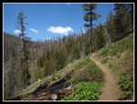
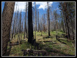
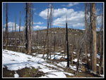
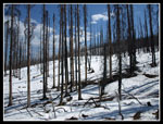
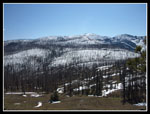
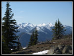
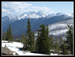
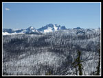
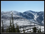
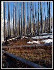
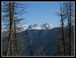
As we rose above the forest views began and kept getting better. We could see back towards Washington Pass and to big peaks to the south. At the end of the long switchback we stopped for lunch. After a steep start most of the trail is pretty gently graded. Steep enough to gain over 3000' but smooth and steady. We could see a low spot in Delancy Ridge and the trail was aiming for it. As we neared this saddle we entered the burn area. Kim mentioned that the Needles Fire in 2003 burned up the second half of the hike.
Before the pass we met a couple who turned around after knee deep mud covered the trail. I reached a junction first. Another couple came down who mentioned the killer mud. They went up the trail to the right which goes to a higher bump on the ridge. Kim caught up and we headed out to see the mud. Hiking in Western Washington we were intrigued to see what could be as bad as what we usually see. Well, the trail was a creek for about 20 feet. A little mud. What a let down.
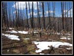
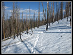
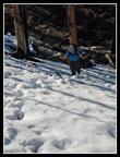
As we contoured around the north side of Delancy Ridge the snow began. First a few patches then more consistent. It was not well past noon and the snow was getting soft. I had many postholes but most were no more than knee deep. My knee deep was a bit deeper for Kim. There were a few footprints and I was able to keep on route. We continued at a pretty level grade crossing a number of small seasonal creeks. The only problems were suspect snow bridges over a few. They held my weight though I had my doubts.
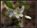
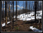
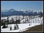
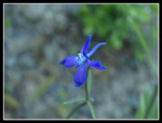
We met a group coming out who did summit Driveway. They confirmed the route that seemed most obvious. We turned to the north and the snow dissipated. In its place we found lots of glacier lilies and spring beauty. A bootpath does go all the way to the summit though it is not obvious in a few places. The last 450' is steeper and back on a hot south slope. Those sparse trees on the butte escaped the fire. A little shade was appreciated.
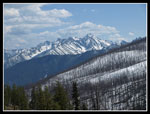
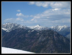
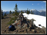
I reached the summit a few minutes ahead of Kim. There is a rock summit cairn and the old lookout's corner posts are still there. Not much else. Views are outstanding. We added all the peaks to the north to those we had been enjoying earlier. The wind was really cold on top. Earlier I was sweating up a storm and now it was time for a coat. The trip down was a bit quicker though the snow was even softer. We did run into several late afternoon groups. They were not going to summit until at least 6:00.
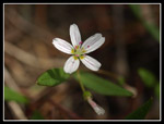
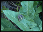
On the way up we crossed an open slope covered in chocolate lilies. I have only seen them on a half dozen hikes. Part of the problem is they blend in so well I never see them. Kim pointed them out and then I could see dozens of them. We took a long break here to photograph them as well as balsamroot and other flowers. It was after 7:30 pm when we reached the truck. I was thinking how nice it would have been to be camped at Klipchuck. Dinner in just a few minutes. Oh well...
We drove down to Winthrop then up the West Chewuch Road. Campsites - all full. Off road sites - all full. We kept driving and found nothing at all. After dark it was even a little tougher. Twenty miles up the road and still nothing. Finally we found a side road blocked only about 50' from the road. Beggars can't be choosers. We took it. We set up camp in the dark then started cooking dinner. It was 11:30 when we went to bed. We definitely milked every moment out of the day.
Kim's report is here: Nwhikers Report & Photos
Click on thumbnails to get larger pictures.
Trips - 2009
Home
There were still two open campsites but we chose to take our chances up the Chewuch River as we planned to hike up there too. It was already 10:50 and getting warm when we started up the trail. Kim had done the trail once before without snow and with trees. A fire burned up the second half of the route. It would be interesting for her to compare forest to burn. The maps show this trail being 4 miles each way. They also show the trail going straight up with on switchback to the right. I believe some rerouting has lengthened the trail. There are now several switchbacks. One is very long.
The flower show was excellent. Balsamroot began immediately and continued all the way up the south slope to the burn. We also saw lots of paintbrush, larkspur, waterleaf, and others. One open slope was covered in desert parsley. Much better flowers than I was expecting. While traversing to the right I heard the sound of a grouse. A quick look around showed a male grouse making the racket. He was not going anywhere so we had time to chance to telephoto lenses without him leaving. It was getting hot. Fortunately there was an intermittent cool breeze.
As we rose above the forest views began and kept getting better. We could see back towards Washington Pass and to big peaks to the south. At the end of the long switchback we stopped for lunch. After a steep start most of the trail is pretty gently graded. Steep enough to gain over 3000' but smooth and steady. We could see a low spot in Delancy Ridge and the trail was aiming for it. As we neared this saddle we entered the burn area. Kim mentioned that the Needles Fire in 2003 burned up the second half of the hike.
Before the pass we met a couple who turned around after knee deep mud covered the trail. I reached a junction first. Another couple came down who mentioned the killer mud. They went up the trail to the right which goes to a higher bump on the ridge. Kim caught up and we headed out to see the mud. Hiking in Western Washington we were intrigued to see what could be as bad as what we usually see. Well, the trail was a creek for about 20 feet. A little mud. What a let down.
As we contoured around the north side of Delancy Ridge the snow began. First a few patches then more consistent. It was not well past noon and the snow was getting soft. I had many postholes but most were no more than knee deep. My knee deep was a bit deeper for Kim. There were a few footprints and I was able to keep on route. We continued at a pretty level grade crossing a number of small seasonal creeks. The only problems were suspect snow bridges over a few. They held my weight though I had my doubts.
We met a group coming out who did summit Driveway. They confirmed the route that seemed most obvious. We turned to the north and the snow dissipated. In its place we found lots of glacier lilies and spring beauty. A bootpath does go all the way to the summit though it is not obvious in a few places. The last 450' is steeper and back on a hot south slope. Those sparse trees on the butte escaped the fire. A little shade was appreciated.
I reached the summit a few minutes ahead of Kim. There is a rock summit cairn and the old lookout's corner posts are still there. Not much else. Views are outstanding. We added all the peaks to the north to those we had been enjoying earlier. The wind was really cold on top. Earlier I was sweating up a storm and now it was time for a coat. The trip down was a bit quicker though the snow was even softer. We did run into several late afternoon groups. They were not going to summit until at least 6:00.
On the way up we crossed an open slope covered in chocolate lilies. I have only seen them on a half dozen hikes. Part of the problem is they blend in so well I never see them. Kim pointed them out and then I could see dozens of them. We took a long break here to photograph them as well as balsamroot and other flowers. It was after 7:30 pm when we reached the truck. I was thinking how nice it would have been to be camped at Klipchuck. Dinner in just a few minutes. Oh well...
We drove down to Winthrop then up the West Chewuch Road. Campsites - all full. Off road sites - all full. We kept driving and found nothing at all. After dark it was even a little tougher. Twenty miles up the road and still nothing. Finally we found a side road blocked only about 50' from the road. Beggars can't be choosers. We took it. We set up camp in the dark then started cooking dinner. It was 11:30 when we went to bed. We definitely milked every moment out of the day.
Kim's report is here: Nwhikers Report & Photos
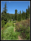 Start Of The Trail |
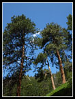 Pine Trees |
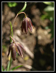 Chocolate Lilies |
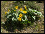 Balsamroot |
 First Mountain View |
 Lots Of Balsamroot |
 Male Grouse |
 View West |
 Delancy Ridge |
 Saddle Ahead |
 Spring Beauty |
 Another Beauty |
 Into The Burn |
 Snow & Summit View |
 Kim On Snow |
 Silver & Black Spires |
 Glacier Lilies |
 Driveway Butte Ahead |
 Snow & Snags |
 Peak, Forest, & Burn |
 Totally Burned |
 Up To The Summit |
 Southwest Views |
 Looking Northwest |
 More Peaks |
 Big Mountain |
 Peak/Burn Contrast |
 Summit Cairn |
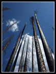
 Converging Lines |
 Heading Back |
 Postholing Uphill |
 Nice Colors |
 Framed Peaks |
 Indian Paintbrush |
 Chocolate Lily On Leaf |
 Larkspur |
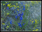 Blue & Yellow |
 Balsamroot Bush |
 Balsamroot Flower |
 Flowering Trees |
Trips - 2009
Home