6/27-28/09
The Suiattle
River Road washed out at Downey Creek in 2003. The last
few miles required walking or biking. In 2006 the road washed out
again, this time 8 1/2 miles before Downey Creek. In 2007 Kim and I
rode bikes to the end of the road and hiked up Sulphur Mountain. On the
way we stopped at Downey Creek and looked for the long abandoned lower
part of the Green Mountain Trail. The current trailhead is nearly six
miles up a logging road leaving only four miles to the summit of Green
Mountain. With the road in place the lower trail was abandoned and has
seen little use for the last 45+ years. We found two outhouses and a
few cut logs but the route soon ended where Downey Creek took out the
hillside. We thought seriously about coming back sometime to try to hike
the old trail.
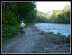
This spring Kim brought up the idea again and we planned to give it a shot. She chose the weekend of her birthday for the adventure. Randy Schroder, another nwhiker member, joined us. We headed out of Seattle on Friday afternoon. We headed through Darrington and north to the Suiattle River Road. The washout is at about 12 1/2 miles. There we found a half dozen vehicles including Randy's. We had overnight packs including ice axes. Randy managed to mount his pack on his backrack. Kim and I had boxes on our racks for boots and to support our packs to relieve the weight. The arrangements worked pretty well.
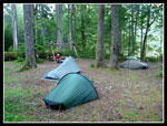
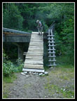
By 7:40 pm we were on our way. The road is a steady gentle climb most of the way. The worst washout now goes farther inland than the one we biked in 2007. The bad silty sections of the road were also more consolidated and much easier to bike. The biggest hill is up to the Green Mountain Road. One could bike up the nearly six miles of road to the trailhead. In my case I would likely need to walk my bike up the road. That would negate the adventure of the old abandoned trail though. Randy and I reached Downey Creek at about 9:15 and Kim soon after. We stashed our bikes near the trailhead and brought our packs across the Downey Creek Bridge to the campgrounds. Randy marveled at how half the campground is gone. The Suiattle River channel is now much wider here.
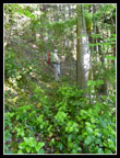
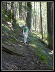
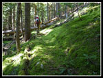
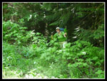
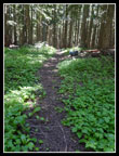
We set up camp just as dark settled in. By 10:15 we were off to bed. Not knowing how long the old trail would take we chose to get an early start. Up at 6:00 am and on our way by 7:30. An obvious trail near the road takes you up to a slightly higher bench. There is another outhouse here. A trail goes beyond the outhouse but this is where we found the trail falling into the river on our 2007 exploration. A little looking showed tape farther south that led up the steep hillside. It's overgrown but there is tread here. The route quickly flattens and heads more westerly.
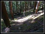
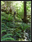
We had an old map that helped some. The route disappears in just a few places and there was plastic tape there to help us get back on route. Much to our surprise, the tread does still go all the way up. The forest provides a darkening cover and underbrush is minimal. In many places the trail is covered with six inches of moss. It can be hard to see but it's still there. We crossed no creeks and consequently there is no water erosion damage. If the trees were cut out and a little maintenance performed the route would still be just fine.
We were also surprised that an old lookout trail would be so gentle. It is not much more than a 10 percent grade anywhere. Oh, I did mentioned downed logs. There are many of those. Lots are step overs but there are some that are five feet in diameter. Those require straddling while trying not to slide down the log. None proved to be too difficult even with overnight backpacks on. The day was getting warm fast and I was sweating. The only water on the whole trail to the tarns is a creek just above the new trailhead. We had to carry enough for the old trail and resupply for the new trail.
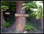
The end of the route did differ from the old map. The map shows the trail hitting the road .75 miles from the new trailhead, following the road for about .25 miles then going above the road and meeting the new trail a short way up from the parking lot. Instead we came out to the road only about .25 miles from the parking lot and several hundred feet higher than expected. We quickly reached the trailhead. The trail register is new and we were the second party to sign in. One log lying along the trail forces climbing down to get around it but otherwise the trail was easy to hike through the forest. The road washout has only had this trail closed for two summers so it was not too bad.
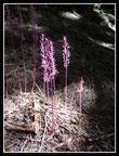
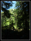
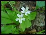
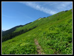
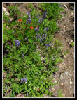
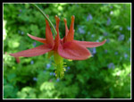
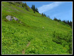
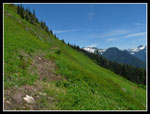
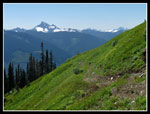
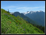
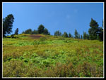
Where the trail begins to climb out of the forest there are several trees which fell right on the trail. This requires either walking along the tree or working around branches on the side. Above there the trail is fine all the way up though a little eroded in places. Flowers are beginning and already look great. Violets, bleeding hearts, and finishing trillium down low and lots of flowers up high. We saw lupine, paintbrush, columbine, strawberries, bistort, valerian, more violets, glacier lilies, and many more.
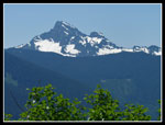
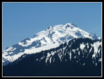
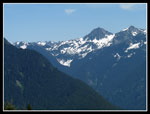
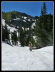
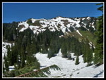
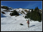
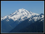
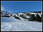
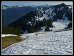
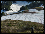
Views improved with every step. Glacier Peak, White Chuck Mountain, Pugh, Sloan, Whitehorse Three Fingers, Sulphur, Meadow Mountain, and many more. Blue sky, warm but not hot, and peaks in all directions but north. We swithcbacked up and up the meadowed hillside and the trail finally turned to the north. There was a snowpatch, some dirt, then we walked into winter. Within a few feet we went from dirt trail to 3 feet of snow. I expected snow but not this much.
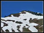
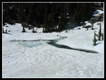
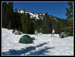
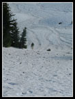
The route now drops 200' to the basin and tarns. The center of one tarn is slowly melting out. No need to look for campsites as we just selected a nice flat bump with snow probably five feet deep. After setting up camp we just rested. It was comfortably warm on the snow. After dinner we chose to climb up Green Mountain. We left at 5:50 pm following the route of the summer trail until under the summit. From there we climbed snow most of the way up. We exited the snow briefly near the top and found a colony of marmots. On my two previous visits I saw lots of marmots and this trip was no different. One more snow slope and some heather and we came out on the summer trail a few hundred feet below the summit. By 7:15 pm we were on top. Kim achieved her wish of reaching the summit of Green on her birthday.
Fantastic views from the summit. We could see the route of the Ptarmigan Traverse from Dome north. Snowking, Chaval, and that group were now in sight. A fantastic place to be, especially as the sun began to set. A cold wind required more clothing but we braved the cold for a full hour on top. At 8:15 we headed down. The snow proved to be perfect for plunge stepping and the steep slope down was lots of fun. We were back at camp by 9:00 pm.
Sunday dawned with low clouds obscuring the summit but slivers of blue. We knew there was a chance of rain but it never happened. Instead, the weather kept improving all day. We slept in until 7:00 and were ready to head down by 8:30. The partial clouds did help in taking photos. Much less glare. Many flower and peak photos were taken as we each set our own pace. We met again at the trailhead parking lot.
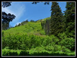
We did stay close together descending the old trail. We did well though again had a few trouble spots. The worst one was only 300' above the lower trailhead. We looked high and low and were ready to just bushwhack it when Randy found the route behind yet another downed log. From there were were back in no time. The ride out was much easier. I guess there was more gentle uphill coming in than I remembered. Much of the way out I was coasting. I caught up with Randy who was photographing a meadow. I couldn't figure out why until we told me it was the Green Mountain Road. The road "Y"s off where it leaves the Suiattle Road. One side is grassy the other side is virtually a meadow. All that in just a few years.
We met Omygoshjosh from Nwhikers on the way out. He summited Sulphur Mountain at 2:00 am Sunday and bivied on top. That almost put our adventure to shame. By 5:00 pm were were back at the truck. This was a really fun trip. Exploring a very long abandoned trail. Finding it in relatively good shape. Camping in a snowy basin. Summiting Green Mountain in the evening. Really nice flowers on the meadowy hillside and great company. I wonder what Kim will cook up for her next birthday?
Click on thumbnails to get larger pictures.
Photo Page 2
Trips - 2009
Home
This spring Kim brought up the idea again and we planned to give it a shot. She chose the weekend of her birthday for the adventure. Randy Schroder, another nwhiker member, joined us. We headed out of Seattle on Friday afternoon. We headed through Darrington and north to the Suiattle River Road. The washout is at about 12 1/2 miles. There we found a half dozen vehicles including Randy's. We had overnight packs including ice axes. Randy managed to mount his pack on his backrack. Kim and I had boxes on our racks for boots and to support our packs to relieve the weight. The arrangements worked pretty well.
By 7:40 pm we were on our way. The road is a steady gentle climb most of the way. The worst washout now goes farther inland than the one we biked in 2007. The bad silty sections of the road were also more consolidated and much easier to bike. The biggest hill is up to the Green Mountain Road. One could bike up the nearly six miles of road to the trailhead. In my case I would likely need to walk my bike up the road. That would negate the adventure of the old abandoned trail though. Randy and I reached Downey Creek at about 9:15 and Kim soon after. We stashed our bikes near the trailhead and brought our packs across the Downey Creek Bridge to the campgrounds. Randy marveled at how half the campground is gone. The Suiattle River channel is now much wider here.
We set up camp just as dark settled in. By 10:15 we were off to bed. Not knowing how long the old trail would take we chose to get an early start. Up at 6:00 am and on our way by 7:30. An obvious trail near the road takes you up to a slightly higher bench. There is another outhouse here. A trail goes beyond the outhouse but this is where we found the trail falling into the river on our 2007 exploration. A little looking showed tape farther south that led up the steep hillside. It's overgrown but there is tread here. The route quickly flattens and heads more westerly.
We had an old map that helped some. The route disappears in just a few places and there was plastic tape there to help us get back on route. Much to our surprise, the tread does still go all the way up. The forest provides a darkening cover and underbrush is minimal. In many places the trail is covered with six inches of moss. It can be hard to see but it's still there. We crossed no creeks and consequently there is no water erosion damage. If the trees were cut out and a little maintenance performed the route would still be just fine.
We were also surprised that an old lookout trail would be so gentle. It is not much more than a 10 percent grade anywhere. Oh, I did mentioned downed logs. There are many of those. Lots are step overs but there are some that are five feet in diameter. Those require straddling while trying not to slide down the log. None proved to be too difficult even with overnight backpacks on. The day was getting warm fast and I was sweating. The only water on the whole trail to the tarns is a creek just above the new trailhead. We had to carry enough for the old trail and resupply for the new trail.
The end of the route did differ from the old map. The map shows the trail hitting the road .75 miles from the new trailhead, following the road for about .25 miles then going above the road and meeting the new trail a short way up from the parking lot. Instead we came out to the road only about .25 miles from the parking lot and several hundred feet higher than expected. We quickly reached the trailhead. The trail register is new and we were the second party to sign in. One log lying along the trail forces climbing down to get around it but otherwise the trail was easy to hike through the forest. The road washout has only had this trail closed for two summers so it was not too bad.
Where the trail begins to climb out of the forest there are several trees which fell right on the trail. This requires either walking along the tree or working around branches on the side. Above there the trail is fine all the way up though a little eroded in places. Flowers are beginning and already look great. Violets, bleeding hearts, and finishing trillium down low and lots of flowers up high. We saw lupine, paintbrush, columbine, strawberries, bistort, valerian, more violets, glacier lilies, and many more.
Views improved with every step. Glacier Peak, White Chuck Mountain, Pugh, Sloan, Whitehorse Three Fingers, Sulphur, Meadow Mountain, and many more. Blue sky, warm but not hot, and peaks in all directions but north. We swithcbacked up and up the meadowed hillside and the trail finally turned to the north. There was a snowpatch, some dirt, then we walked into winter. Within a few feet we went from dirt trail to 3 feet of snow. I expected snow but not this much.
The route now drops 200' to the basin and tarns. The center of one tarn is slowly melting out. No need to look for campsites as we just selected a nice flat bump with snow probably five feet deep. After setting up camp we just rested. It was comfortably warm on the snow. After dinner we chose to climb up Green Mountain. We left at 5:50 pm following the route of the summer trail until under the summit. From there we climbed snow most of the way up. We exited the snow briefly near the top and found a colony of marmots. On my two previous visits I saw lots of marmots and this trip was no different. One more snow slope and some heather and we came out on the summer trail a few hundred feet below the summit. By 7:15 pm we were on top. Kim achieved her wish of reaching the summit of Green on her birthday.
Fantastic views from the summit. We could see the route of the Ptarmigan Traverse from Dome north. Snowking, Chaval, and that group were now in sight. A fantastic place to be, especially as the sun began to set. A cold wind required more clothing but we braved the cold for a full hour on top. At 8:15 we headed down. The snow proved to be perfect for plunge stepping and the steep slope down was lots of fun. We were back at camp by 9:00 pm.
Sunday dawned with low clouds obscuring the summit but slivers of blue. We knew there was a chance of rain but it never happened. Instead, the weather kept improving all day. We slept in until 7:00 and were ready to head down by 8:30. The partial clouds did help in taking photos. Much less glare. Many flower and peak photos were taken as we each set our own pace. We met again at the trailhead parking lot.
We did stay close together descending the old trail. We did well though again had a few trouble spots. The worst one was only 300' above the lower trailhead. We looked high and low and were ready to just bushwhack it when Randy found the route behind yet another downed log. From there were were back in no time. The ride out was much easier. I guess there was more gentle uphill coming in than I remembered. Much of the way out I was coasting. I caught up with Randy who was photographing a meadow. I couldn't figure out why until we told me it was the Green Mountain Road. The road "Y"s off where it leaves the Suiattle Road. One side is grassy the other side is virtually a meadow. All that in just a few years.
We met Omygoshjosh from Nwhikers on the way out. He summited Sulphur Mountain at 2:00 am Sunday and bivied on top. That almost put our adventure to shame. By 5:00 pm were were back at the truck. This was a really fun trip. Exploring a very long abandoned trail. Finding it in relatively good shape. Camping in a snowy basin. Summiting Green Mountain in the evening. Really nice flowers on the meadowy hillside and great company. I wonder what Kim will cook up for her next birthday?
 Randy Riding By Washout |
 Downey Ck Campsite |
 Downey Ramp |
 Start Of Old Trail |
 Kim On Old Tread |
 Switchbacking Up |
 Partly Obscured |
 Thick Moss On Trail |
 No Chlorophyll |
 Kim Reaching Road |
 Green Mountain Trail |
 Green Slopes Above |
 Green Ground Cover |
 Leaving Forest |
 White Chuck Mountain |
 Spring Beauty |
 Patch Of Snow |
 Glacier Peak Appears |
 Lupine & Paintbrush |
 Columbine |
 Randy In Green |
 Sloughing Trail |
 More Peaks |
 Whitehorse - Whitechuck |
 Flowers And Peaks |
 Many Shades |
 On Snow |
 Green Mt. Summit |
 Ridge Of Green Mt. |
 Tarn Starting To Melt |
 Lounging Around |
 Campsite |
 Heading For Summit |
 Glacier Peak |
 Slope To Ridge |
 Kim Climbing |
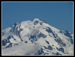 Zoomed Glacier |
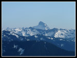 Sloan Peak |
 Traversing On Snow |
 Marmot Haven |
Photo Page 2
Trips - 2009
Home