5/16-17/09
A spring
backpacking trip to a Teanaway peak summit has become a tradition. Gary
had done day trips up Iron on snow but had not camped on the summit. To
really enjoy a summit stay the weather needs to be clear enough to
provide good sunset and sunrise photos. With good weather
forecast we planned a trip. The road is now snow free to the Beverly
Creek trailhead. The NF Teanaway Road is as potholed as I can recall.
The Beverly Creek Road has senseless drains cut across it. Slow down
for them or beat up your car. We were on the trail by about 9:40.
Iron has become the summit of the spring as there have been a number of trip reports the last three weeks. Most went up the south ridge and down Beverly Creek. Bean Creek usually runs in three channels in the spring. I was very surprised to see all the water was in the middle channel. Gary was able to jump rocks but I used dive booties to get across. The water was nearly knee deep. I fell into the creek last year after a pole malfunction and seriously mangled my knee. This year I was a bit more careful.
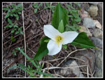
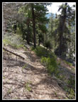
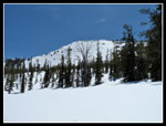
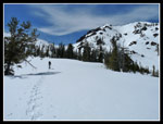
Across the creek we found a lot of glacier lilies and spring beauty. Very nice flower show. It was another 1/3 mile or so before we found snow on the trail. After passing the talus field snow began and soon the trail was all under snow. The snow was firm enough to allow for just boots though most tracks were from snowshoes. This section is in forest. We came out of the forest along the creek and the snow was much softer.
We booted it a little longer then snowshoes went on. It was already warmer than forecast. I was sweating like crazy. With a 35 lb. winter pack I was feeling the weight and the heat. I took my sunglasses out of my pack for driving and about now I realized they were still in the car. Not smart. There was an avalanche warning so I planned a little different route this time. Instead of climbing beneath the summit and ascending straight up I decided to head to the low pass between Iron and Teanaway Peaks. The summer trail goes there.
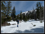
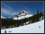
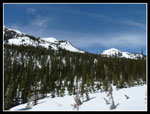
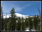
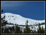
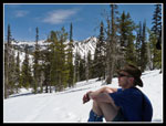
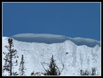
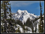
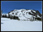
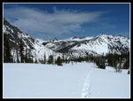
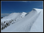
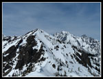
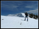
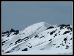
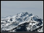
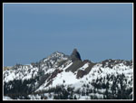
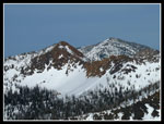
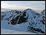
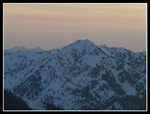
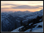
We passed one snow bridge across Beverly Creek and continued up the valley. There were less snow bridges than usual but Gary found one that took us across. The route provided a steady climb. As we ascended the views began. Volcanic Neck came into view over Fourth Creek Pass. Teanaway Peak was to our right and the long corniced ridge of Iron Peak was ahead and to our left. As the forest thinned we stopped for lunch and admired the views.
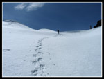
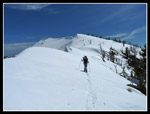
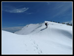
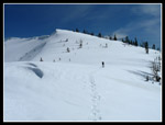
More climbing brought us to the base of the pass. There is only about 100' to the ridge top. It was soft enough that we just snowshoed right up. There was no cornice just left to the pass. We knew to keep away from the cornices. The ridge walk was gentle with one steep section. At the base of that section we found tracks dropping down to the valley. We now had tracks all along the ridge to the summit.
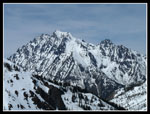
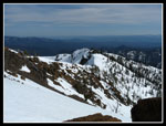
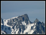
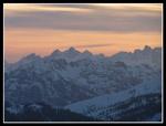
Views to the west and northwest grew. Hawkins, Esmeralda, and soon Daniel. Mt. Stuart was now right behind us. There were a few clouds but the sky was mostly clear. We worked our way higher and dropped our packs at the camp site. From there it was just a short walk to the summit. I was a little surprised to find the summit register not snow covered. The register book is less than half full. There were no signing this year though I found a piece of paper with a 2-2-09 date. Looks like we were the second group to sign in though not the second group to summit this year.
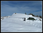
Gary had stopped and put on more clothes. I headed straight to the summit. There was a cool breeze blowing and I headed down before him. After breaking out my jacket I got to work leveling a tent site. Gary joined me and we used both shovels. It still took us awhile to finish the site. The tent went up and we dug out a nice deep pit under the vestibule. Getting in and out of the tent was much easier. The wind began to pick up and we had to use the vestibule for the stove. We cooked dinner and melted snow for drinking too. Gary noticed two folks down the ridge. We watched as they skied off the ridge and down into the valley. It was past 6:00 pm so they were turning around pretty late in the day.
We retired to the tent to get out of the wind and come back outside around 8:15. The sun was beginning to set and the colors began. Earlier I was afraid that clouds over the crest would blot out the sunset colors. Instead the clouds lightened but there ware enough left to really light up the sky. We spent over half an hour enjoying the sunset and taking photographs. The colors were the best I have seen on Iron. It was getting really cold when we called it a night.
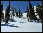
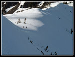
In the tent it was not too bad at all. Neither of us was cold during the night. I realized I had forgotten an extra pair of socks but I kept them on all night and they were dry in the morning. Gary had checked the time of sunrise and he unzipped the tent at around 5:20 am. Mt. Stuart was right in front of us and the sun was just rising. Pretty good color though not as good as the sunset had been. We hoped to glissade off the summit but were wary of the avalanche danger. We saw many sloughs from the day before. We needed to get going by around 10:00 of the sun would make the snow too soft.
With that in mind we were packed up and on our way by about 10:15. The ridge top snow was icy and hard at sun up but was already softening. If we deemed glissading to be to risky we would follow our route the day before off the summit ridge. A short walk took us to the best glissade spot. It was a gap in the cornices. The drop is about 450'. It starts out pretty steep and becomes more gentle farther down. There is a big flat runout at the bottom. It was pretty soft at the top. I went first and had a pretty slow slide down. Gary followed me down. There wasn't much sloughing though it was not a fast descent.
From there we followed tracks down to Beverly Creek. A narrow though thick snow bridge took us across the creek. We stopped for food and to remove more clothing. Two skiers passed us here heading to Iron Peak. The route down was much softer than the day before. We kept snowshoes on for most of our descent. Realizing I did not have any dry socks in the car (another error) I stopped again to use my dive booties to cross Bean Creek. It was a little deeper though not much. Around 1:30 we reached the parking lot. I noticed Suzanne's Highlander in the lot. They went up Earl Peak this day.
This was a great trip. Gary and I had not backpacked since Wing Lake last October. We saw very few people all weekend. The sky was mostly clear and the days were warm. The view of Mt. Stuart right out of our front door was outstanding. The sunset and sunrise were better than I had hoped for. Best of all, I managed to get up and down without tweaking my sore knee. Hopefully I can do some more strenuous climbs again now. Now I'll have to think of a different Teanaway summit for next spring.
Click on thumbnails to get larger pictures.
Photo Page 2
Trips - 2009
Home
Iron has become the summit of the spring as there have been a number of trip reports the last three weeks. Most went up the south ridge and down Beverly Creek. Bean Creek usually runs in three channels in the spring. I was very surprised to see all the water was in the middle channel. Gary was able to jump rocks but I used dive booties to get across. The water was nearly knee deep. I fell into the creek last year after a pole malfunction and seriously mangled my knee. This year I was a bit more careful.
Across the creek we found a lot of glacier lilies and spring beauty. Very nice flower show. It was another 1/3 mile or so before we found snow on the trail. After passing the talus field snow began and soon the trail was all under snow. The snow was firm enough to allow for just boots though most tracks were from snowshoes. This section is in forest. We came out of the forest along the creek and the snow was much softer.
We booted it a little longer then snowshoes went on. It was already warmer than forecast. I was sweating like crazy. With a 35 lb. winter pack I was feeling the weight and the heat. I took my sunglasses out of my pack for driving and about now I realized they were still in the car. Not smart. There was an avalanche warning so I planned a little different route this time. Instead of climbing beneath the summit and ascending straight up I decided to head to the low pass between Iron and Teanaway Peaks. The summer trail goes there.
We passed one snow bridge across Beverly Creek and continued up the valley. There were less snow bridges than usual but Gary found one that took us across. The route provided a steady climb. As we ascended the views began. Volcanic Neck came into view over Fourth Creek Pass. Teanaway Peak was to our right and the long corniced ridge of Iron Peak was ahead and to our left. As the forest thinned we stopped for lunch and admired the views.
More climbing brought us to the base of the pass. There is only about 100' to the ridge top. It was soft enough that we just snowshoed right up. There was no cornice just left to the pass. We knew to keep away from the cornices. The ridge walk was gentle with one steep section. At the base of that section we found tracks dropping down to the valley. We now had tracks all along the ridge to the summit.
Views to the west and northwest grew. Hawkins, Esmeralda, and soon Daniel. Mt. Stuart was now right behind us. There were a few clouds but the sky was mostly clear. We worked our way higher and dropped our packs at the camp site. From there it was just a short walk to the summit. I was a little surprised to find the summit register not snow covered. The register book is less than half full. There were no signing this year though I found a piece of paper with a 2-2-09 date. Looks like we were the second group to sign in though not the second group to summit this year.
Gary had stopped and put on more clothes. I headed straight to the summit. There was a cool breeze blowing and I headed down before him. After breaking out my jacket I got to work leveling a tent site. Gary joined me and we used both shovels. It still took us awhile to finish the site. The tent went up and we dug out a nice deep pit under the vestibule. Getting in and out of the tent was much easier. The wind began to pick up and we had to use the vestibule for the stove. We cooked dinner and melted snow for drinking too. Gary noticed two folks down the ridge. We watched as they skied off the ridge and down into the valley. It was past 6:00 pm so they were turning around pretty late in the day.
We retired to the tent to get out of the wind and come back outside around 8:15. The sun was beginning to set and the colors began. Earlier I was afraid that clouds over the crest would blot out the sunset colors. Instead the clouds lightened but there ware enough left to really light up the sky. We spent over half an hour enjoying the sunset and taking photographs. The colors were the best I have seen on Iron. It was getting really cold when we called it a night.
In the tent it was not too bad at all. Neither of us was cold during the night. I realized I had forgotten an extra pair of socks but I kept them on all night and they were dry in the morning. Gary had checked the time of sunrise and he unzipped the tent at around 5:20 am. Mt. Stuart was right in front of us and the sun was just rising. Pretty good color though not as good as the sunset had been. We hoped to glissade off the summit but were wary of the avalanche danger. We saw many sloughs from the day before. We needed to get going by around 10:00 of the sun would make the snow too soft.
With that in mind we were packed up and on our way by about 10:15. The ridge top snow was icy and hard at sun up but was already softening. If we deemed glissading to be to risky we would follow our route the day before off the summit ridge. A short walk took us to the best glissade spot. It was a gap in the cornices. The drop is about 450'. It starts out pretty steep and becomes more gentle farther down. There is a big flat runout at the bottom. It was pretty soft at the top. I went first and had a pretty slow slide down. Gary followed me down. There wasn't much sloughing though it was not a fast descent.
From there we followed tracks down to Beverly Creek. A narrow though thick snow bridge took us across the creek. We stopped for food and to remove more clothing. Two skiers passed us here heading to Iron Peak. The route down was much softer than the day before. We kept snowshoes on for most of our descent. Realizing I did not have any dry socks in the car (another error) I stopped again to use my dive booties to cross Bean Creek. It was a little deeper though not much. Around 1:30 we reached the parking lot. I noticed Suzanne's Highlander in the lot. They went up Earl Peak this day.
This was a great trip. Gary and I had not backpacked since Wing Lake last October. We saw very few people all weekend. The sky was mostly clear and the days were warm. The view of Mt. Stuart right out of our front door was outstanding. The sunset and sunrise were better than I had hoped for. Best of all, I managed to get up and down without tweaking my sore knee. Hopefully I can do some more strenuous climbs again now. Now I'll have to think of a different Teanaway summit for next spring.
 Trillium |
 Bare Trail |
 Out Of The Forest |
 Bill Peak |
 Iron & Teanaway Peaks |
 Passing Iron Peak |
 Corniced Iron |
 Gary At Lunch |
 Sloughing Under Cornices |
 Mt. Stuart In Sight |
 Summit Of Iron |
 Teanaway Peak |
 Heading To Pass |
 Fourth Creek Pass |
 Pass Just Ahead |
 Gary Nears Pass |
 Iron Ridge From Pass |
 Gary Along Ridge |
 Wispy Clouds |
 Nearing Old Tracks |
 Ridge To Teanaway Peak |
 Summit Is Getting Close |
 Classic Stuart Shot |
 Iron's South Ridge |
 Fortune Peak |
 Hawkins Mountain |
 Little Annapurna |
 Iron Summit Camp |
 Volcanic Neck |
 Bean & Navaho |
 Skiers On Ridge |
 Shade On Teanaway |
 Start Of Sunset |
 Color Over Crest |
 Just Enough Clouds |
Photo Page 2
Trips - 2009
Home