2-28-09
After many weeks
of no snow we
finally had a small dump in the mountains. Where to go? As usual we had
no idea on Friday night. A consensus finally gelled around a trip up
Mt. Higgins to the old lookout site. I have summited one time in the
winter via the ridge. It included crossing a steep open slope to get
around the summit block. I did not want to have to do that after the
recent new snow and the chance it would slide. Going straight up is
more protected in forest. That is the route we took down on that trip.
Suzanne and I also tried once on snow. We were turned back about 600'
below the summit by very deep soft snow.
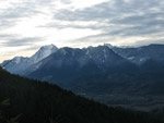
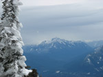
In the summer there is a nice trail all the way up. In the winter it's a bit tougher as you can't see the summit from most of the route. There is no obvious ridge to follow either. The other problem can be getting across Dick's Creek. In the spring it can be too deep to safely ford or rock hop. We also did not know if the road to the trailhead was snow free. With those points in mind Suzanne, Barry, and I met Bob and Kolleen C Post Road where it turns off from the road to Darrington. The trail was closed for several years while logging went on. It was reopened when we did the winter ridge route in 2007. It was much different on the drive up. There are no more trees from the river up to the trailhead. There are now views out to the mountains to the south and the valley below.
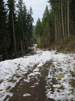
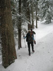
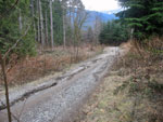
8/10ths of a mile from the trailhead the road has deep water ruts in three places. It would be challenging for a sedan to get through. We had two SUVs and touched bottom once but made it up and down okay. at the trailhead was one truck. We were on the trail before 9:00 am. The route starts on the closed off end of the recent logging road. It was muddy in 2007 but is now mostly grass. It was cold but we warmed up quickly heading uphill. There was no snow on the road and only a little at the start of the trail. We came out into the open where the trail traverses on open slope and it too was snow free.
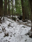
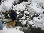
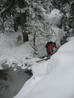
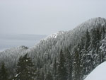
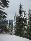
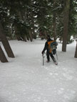
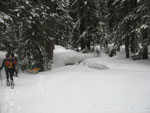
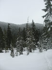
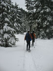
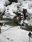
We entered forest and the snow began. A dusting soon became enough to cover the trail though it was still easy to follow. By the time we reached Dick's Creek the snow was deeper. It was well enough compacted to allow for easy travel. The water level in the creek was not too high. Unfortunately the rocks along the side were icy. It was challenging to jump across but we all made it with dry feet. Once on the other side we followed the foot prints left by the other group that morning. The route is mostly just straight uphill along the creek. When the grade flattened we stopped for a food break and to put on snowshoes. The forest was thinner here and the fresh snow deeper.
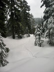
We followed the track across the flats and then it began to drop. That did not seem right but we followed it down to a creek crossing. We found a log and gingerly crossed well above the water. A few minutes later we reached snow covered Myrtle Lake. Oops! That was not part of the plan. We pulled out the map and Kolleen's GPS to help with navigation. The topography is not very distinct and we worked to get back on track.
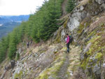
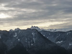
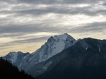
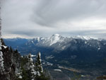
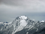
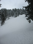
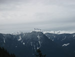
It felt like we were almost turning around but we were in fact heading towards the summit. We headed up a draw and then onto a good terrain to work our way uphill. A big open slope appeared to our left. What side of it did we need to be on? Our slope looked good. The other side looked to be much steeper than I remembered coming down. We continued on up. The only steep section was near the ridge top. The wind also began to blow hard as we neared the top. We popped out on a rounded ridge in a spot Suzanne and I both recognized. The ridge had a near vertical step and the summit was right above.
We were at the point I did not want to see. We just needed to cross the top of the big open slope, contour around the summit and head straight up. Maybe 100 vertical feet and less than 10 minutes away. The amount of unconsolidated snow made out decision easy. It was too risky to cross the slope. So close yet so far. The summit was not to be this day. We opted to exchange snowshoes for Microspikes, crampons, or just boots. The wind was very strong on the ridge. Trees were covered on one side with rime ice. A few more photos and down we headed.
It did not take long to drop 500' and get out of the wind. It was a little after noon when we had our lunch. After that it was back to snowshoes. We took a more direct route down. It allowed us to avoid crossing the creek on the narrow log again. We reached our track above Myrtle Lake. One short uphill and it was all downhill to Dick's Creek. It had warmed up enough to make the snow in the trees melt and rain down on us a little. We did fine on the recrossing of the creek. The water was no higher and some of the ice on rocks had melted. From there it was just a slog out on less and less snow until we exited the forest and were back on dirt.
At the trailhead there were now no other vehicles. We made it over the washouts in the road with no problems. We did not make the summit but I had a great time. Views from the ridge were great and the snow conditions were pretty good. This is not an easy route to navigate and it proved to be the case this day. If the snow conditions had been more stable we could have summited but safety was more important. The mountain will still be there when we come back.
Barry's report is here: Nwhikers Report & Photos
Click on thumbnails to get larger pictures.
Trips - 2009
Home
In the summer there is a nice trail all the way up. In the winter it's a bit tougher as you can't see the summit from most of the route. There is no obvious ridge to follow either. The other problem can be getting across Dick's Creek. In the spring it can be too deep to safely ford or rock hop. We also did not know if the road to the trailhead was snow free. With those points in mind Suzanne, Barry, and I met Bob and Kolleen C Post Road where it turns off from the road to Darrington. The trail was closed for several years while logging went on. It was reopened when we did the winter ridge route in 2007. It was much different on the drive up. There are no more trees from the river up to the trailhead. There are now views out to the mountains to the south and the valley below.
8/10ths of a mile from the trailhead the road has deep water ruts in three places. It would be challenging for a sedan to get through. We had two SUVs and touched bottom once but made it up and down okay. at the trailhead was one truck. We were on the trail before 9:00 am. The route starts on the closed off end of the recent logging road. It was muddy in 2007 but is now mostly grass. It was cold but we warmed up quickly heading uphill. There was no snow on the road and only a little at the start of the trail. We came out into the open where the trail traverses on open slope and it too was snow free.
We entered forest and the snow began. A dusting soon became enough to cover the trail though it was still easy to follow. By the time we reached Dick's Creek the snow was deeper. It was well enough compacted to allow for easy travel. The water level in the creek was not too high. Unfortunately the rocks along the side were icy. It was challenging to jump across but we all made it with dry feet. Once on the other side we followed the foot prints left by the other group that morning. The route is mostly just straight uphill along the creek. When the grade flattened we stopped for a food break and to put on snowshoes. The forest was thinner here and the fresh snow deeper.
We followed the track across the flats and then it began to drop. That did not seem right but we followed it down to a creek crossing. We found a log and gingerly crossed well above the water. A few minutes later we reached snow covered Myrtle Lake. Oops! That was not part of the plan. We pulled out the map and Kolleen's GPS to help with navigation. The topography is not very distinct and we worked to get back on track.
It felt like we were almost turning around but we were in fact heading towards the summit. We headed up a draw and then onto a good terrain to work our way uphill. A big open slope appeared to our left. What side of it did we need to be on? Our slope looked good. The other side looked to be much steeper than I remembered coming down. We continued on up. The only steep section was near the ridge top. The wind also began to blow hard as we neared the top. We popped out on a rounded ridge in a spot Suzanne and I both recognized. The ridge had a near vertical step and the summit was right above.
We were at the point I did not want to see. We just needed to cross the top of the big open slope, contour around the summit and head straight up. Maybe 100 vertical feet and less than 10 minutes away. The amount of unconsolidated snow made out decision easy. It was too risky to cross the slope. So close yet so far. The summit was not to be this day. We opted to exchange snowshoes for Microspikes, crampons, or just boots. The wind was very strong on the ridge. Trees were covered on one side with rime ice. A few more photos and down we headed.
It did not take long to drop 500' and get out of the wind. It was a little after noon when we had our lunch. After that it was back to snowshoes. We took a more direct route down. It allowed us to avoid crossing the creek on the narrow log again. We reached our track above Myrtle Lake. One short uphill and it was all downhill to Dick's Creek. It had warmed up enough to make the snow in the trees melt and rain down on us a little. We did fine on the recrossing of the creek. The water was no higher and some of the ice on rocks had melted. From there it was just a slog out on less and less snow until we exited the forest and were back on dirt.
At the trailhead there were now no other vehicles. We made it over the washouts in the road with no problems. We did not make the summit but I had a great time. Views from the ridge were great and the snow conditions were pretty good. This is not an easy route to navigate and it proved to be the case this day. If the snow conditions had been more stable we could have summited but safety was more important. The mountain will still be there when we come back.
Barry's report is here: Nwhikers Report & Photos
 Road/Trail |
 Lichen Rocks |
 First View Out |
 Open Section |
 Three Fingers |
 Whitehorse Mountain |
 Back In Forest |
 Crossing Dick's Creek |
 Barry & Suzanne |
 Flocked Trees |
 Another Crossing |
 View From Ridge |
 Whitehorse Close Up |
 View Northeast |
 Rime Ice |
 Mt. Pugh |
 Heading Down |
 Slope We Didn't Cross |
 Across The Flats |
 Unusual Tree |
 Looking At Summit |
 Back In Our Tracks |
 Recrossing Dick's Creek |
 Last View Out |
 Road Damage |
Trips - 2009
Home