8/16-19/09
For the past
three years I have visited my brother in Sun Valley then
gone off on a backpacking trip. The first two years it was a one way
trip through the Sawtooth Mountains. Last year it was in the White
Clouds, just to the east. My first trip was solo, then with Suzanne,
last year with Kim, and this year with Gary. Gary had done a more than
week long trip through the Sawtooths back in 1980. It was has first
return trip in 29 years. He needed to be back by the following Saturday
so we headed out Friday morning to give us a full week.
The drive to Sun Valley is about 650 miles from Seattle. It took us roughly 10 1/2 hours each way driving time. The time change to Mountain Time added an hour going and gave it back on our return. We were in late on Friday. Saturday we needed to get used to the thinner air and chose a hike up High Ridge. It took us to 9400', an altitude we would reach or exceed nearly every day in the Sawtooths. Living at sea level makes the first few days at altitude a little tougher.
Day One
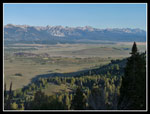
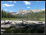
The weather cooperated nicely for our trip. Cooler than normal the first few days then back up to the usual mid 80s at the end. Nights in the mountains were in the upper 30s but well above freezing. Sunday morning we headed north over 8701' Galena Summit and down the Salmon River Valley to our left turn at Decker Flats. It is only 47 miles from Ketchum. A short drive to a "T", a left turn, and in less than half a mile we were at the trailhead for Hell Roaring Lake.
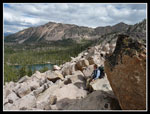
There are two trailheads. Its 5 miles to the lake from the lower trailhead. It's only about 1 3/4 miles from the upper trailhead. The few reports suggested high clearance and four wheel drive were necessary to reach the upper trailhead. Since my brother would be ferrying us back to our car we chose to stick with the longer trail and easy drive. It proved to be a good choice as the trail was amazingly smooth and flat. We averaged three miles per hour up to the lake. Helping our speed were our relatively light packs. Mine was 21 lbs. plus 5 lbs. of food and 4 lbs. of water. That's about 15 - 20 lbs. less than I would have had 6 years ago. Going lighter really helped to keep the trip fun.
Our trailhead was at 6790'. Only a few miles of the trip would be below 7000'. At about 3 miles we reached the Sawtooth Wilderness boundary. We would be in wilderness until the last 1/4 mile of the trip. A half mile later we met the route from the upper trailhead. There were half a dozen cars at the lower trailhead and we soon met the first of those heading home after the weekend. Even with a stop at the wilderness boundary we still reached the lake in two hours. A big group on parents and young girls were just leaving.
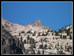
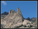
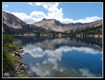
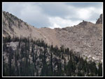
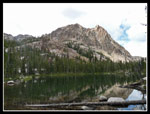
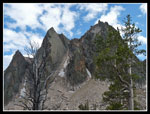
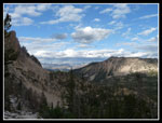
The Sawtooths are known for their granite and we were treated to it early and often. Above Hell Roaring Lake are granite points including the Finger Of Fate and the Arrowhead. Our route circled around Mt. Cramer and we would see the Arrowhead again from our last camp across the ridge at Upper Cramer Lake. The party at the lake mentioned climbing up to a string of lakes near the Finger. We took a break at the lake then headed up the valley. Beyond the lake the trail slowly switchbacks up to even larger Imogene Lake. These are mostly horse trails and the grade seldom exceeds a 10% grade. They are smooth and very gentle.
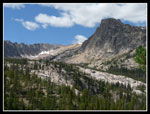
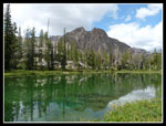
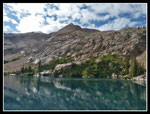
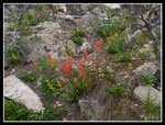
One other point. By mid August this area is very dry. Many small creeks are dry. Most flowers are finished. This year the early summer was wet. We found plenty of water and more wildflowers than expected. It's four miles along 7407' Hell Roaring Lake then up to Imogene at 8436', bringing the days total to nine miles. We took another break there for lunch. We started at 9:00 am and it was still before 1:00 at the lake. Imogene is a big lake with forest and granite all around. Slabs reach down to the lake on the opposite side. Pulling out an old map we saw that the trail used to cross the outlet and go down the other shore.
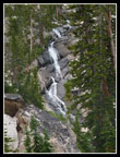
Our objective for the day was Lake 8733. It appeared to be an easy walk gaining 350' from Imogene. It was not. We found the old trail and followed it across a big log jam and around the end of the lake. We then found a more faint trail heading to the right. This is a fairly good fisherman's path that first drops 150' to a small lake. It scrambles over some easy rocks and through forest passing a smaller tarn then reaching another lake. We met a couple before the lake who had gone up to 8733. They went up a tough rock field and came down the other side of the creek finding it much easier. The "easy walk" I had expected was quickly shot down by the view of big waterfalls falling over granite cliffs from the lakes above.
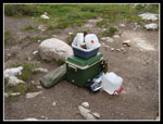
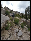
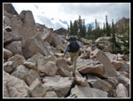
We reached the last lake to find a big ice cooler, a big bagged tent, a jar of jelly, plates, a five gallon water bag, and two empty wine bottles. Who had carried all that many miles up a trail then down a scrambly path? It was a mystery though it did give this lake a new name. From now on we will call it "Cooler Lake". We intended to cross the inlet and take the "easier" route up to Lake 8733. The creek was fast and deep. There were no logs or rocks to hop. Not wanting a thigh deep ford we chose to head up the rocks. There is small scree, bigger talus, rocks, and even boulders. This was a monster boulder field.
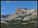
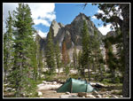
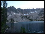
We crossed car sized rocks then smaller ones as the slope steepened. Higher up they were huge. Gaps between boulders looked to be at least 10' deep. We carefully worked our way up. A dirt path appeared and led over to the creek. We crossed and soon reached a big tarn. A water fall fell from Lake 8733 into it. A little more climbing brought us to the lake. It is one magnificent place. A rocky cirque surrounds the lake. Sharp spires on one side and the false summit of Mt. Cramer directly above. Granite abounds and well spaced trees cover the near shore. It's a truly beautiful place.
We set up camp and had dinner. It took us much longer form Imogene than expected. A group of five young fishermen arrived and did not leave until an hour before dark. They were heading all the way back to Hell Roaring Lake. We still had some daylight left and chose to go look for a bootpath up Cramer, our goal for the next morning. We had a little info and a GPS track from this sight: Idaho Summits. It proved helpful and we found the path. We went 400' up to learn more about our route for the next day.
We dropped back to camp a little before sunset and headed to bed. For the day we hiked about 12 miles with 2800' of gain.
Click on thumbnails to get larger pictures.
Day 2
Trips - 2009
Home
The drive to Sun Valley is about 650 miles from Seattle. It took us roughly 10 1/2 hours each way driving time. The time change to Mountain Time added an hour going and gave it back on our return. We were in late on Friday. Saturday we needed to get used to the thinner air and chose a hike up High Ridge. It took us to 9400', an altitude we would reach or exceed nearly every day in the Sawtooths. Living at sea level makes the first few days at altitude a little tougher.
Day One
The weather cooperated nicely for our trip. Cooler than normal the first few days then back up to the usual mid 80s at the end. Nights in the mountains were in the upper 30s but well above freezing. Sunday morning we headed north over 8701' Galena Summit and down the Salmon River Valley to our left turn at Decker Flats. It is only 47 miles from Ketchum. A short drive to a "T", a left turn, and in less than half a mile we were at the trailhead for Hell Roaring Lake.
There are two trailheads. Its 5 miles to the lake from the lower trailhead. It's only about 1 3/4 miles from the upper trailhead. The few reports suggested high clearance and four wheel drive were necessary to reach the upper trailhead. Since my brother would be ferrying us back to our car we chose to stick with the longer trail and easy drive. It proved to be a good choice as the trail was amazingly smooth and flat. We averaged three miles per hour up to the lake. Helping our speed were our relatively light packs. Mine was 21 lbs. plus 5 lbs. of food and 4 lbs. of water. That's about 15 - 20 lbs. less than I would have had 6 years ago. Going lighter really helped to keep the trip fun.
Our trailhead was at 6790'. Only a few miles of the trip would be below 7000'. At about 3 miles we reached the Sawtooth Wilderness boundary. We would be in wilderness until the last 1/4 mile of the trip. A half mile later we met the route from the upper trailhead. There were half a dozen cars at the lower trailhead and we soon met the first of those heading home after the weekend. Even with a stop at the wilderness boundary we still reached the lake in two hours. A big group on parents and young girls were just leaving.
The Sawtooths are known for their granite and we were treated to it early and often. Above Hell Roaring Lake are granite points including the Finger Of Fate and the Arrowhead. Our route circled around Mt. Cramer and we would see the Arrowhead again from our last camp across the ridge at Upper Cramer Lake. The party at the lake mentioned climbing up to a string of lakes near the Finger. We took a break at the lake then headed up the valley. Beyond the lake the trail slowly switchbacks up to even larger Imogene Lake. These are mostly horse trails and the grade seldom exceeds a 10% grade. They are smooth and very gentle.
One other point. By mid August this area is very dry. Many small creeks are dry. Most flowers are finished. This year the early summer was wet. We found plenty of water and more wildflowers than expected. It's four miles along 7407' Hell Roaring Lake then up to Imogene at 8436', bringing the days total to nine miles. We took another break there for lunch. We started at 9:00 am and it was still before 1:00 at the lake. Imogene is a big lake with forest and granite all around. Slabs reach down to the lake on the opposite side. Pulling out an old map we saw that the trail used to cross the outlet and go down the other shore.
Our objective for the day was Lake 8733. It appeared to be an easy walk gaining 350' from Imogene. It was not. We found the old trail and followed it across a big log jam and around the end of the lake. We then found a more faint trail heading to the right. This is a fairly good fisherman's path that first drops 150' to a small lake. It scrambles over some easy rocks and through forest passing a smaller tarn then reaching another lake. We met a couple before the lake who had gone up to 8733. They went up a tough rock field and came down the other side of the creek finding it much easier. The "easy walk" I had expected was quickly shot down by the view of big waterfalls falling over granite cliffs from the lakes above.
We reached the last lake to find a big ice cooler, a big bagged tent, a jar of jelly, plates, a five gallon water bag, and two empty wine bottles. Who had carried all that many miles up a trail then down a scrambly path? It was a mystery though it did give this lake a new name. From now on we will call it "Cooler Lake". We intended to cross the inlet and take the "easier" route up to Lake 8733. The creek was fast and deep. There were no logs or rocks to hop. Not wanting a thigh deep ford we chose to head up the rocks. There is small scree, bigger talus, rocks, and even boulders. This was a monster boulder field.
We crossed car sized rocks then smaller ones as the slope steepened. Higher up they were huge. Gaps between boulders looked to be at least 10' deep. We carefully worked our way up. A dirt path appeared and led over to the creek. We crossed and soon reached a big tarn. A water fall fell from Lake 8733 into it. A little more climbing brought us to the lake. It is one magnificent place. A rocky cirque surrounds the lake. Sharp spires on one side and the false summit of Mt. Cramer directly above. Granite abounds and well spaced trees cover the near shore. It's a truly beautiful place.
We set up camp and had dinner. It took us much longer form Imogene than expected. A group of five young fishermen arrived and did not leave until an hour before dark. They were heading all the way back to Hell Roaring Lake. We still had some daylight left and chose to go look for a bootpath up Cramer, our goal for the next morning. We had a little info and a GPS track from this sight: Idaho Summits. It proved helpful and we found the path. We went 400' up to learn more about our route for the next day.
We dropped back to camp a little before sunset and headed to bed. For the day we hiked about 12 miles with 2800' of gain.
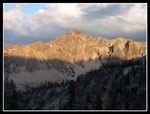
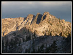
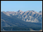 Mt. Cramer From Highwy |
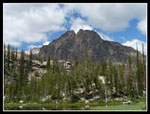
 Sawtooth Range |
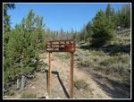 Hell Roaring Trailhead |
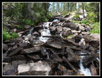
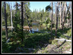 Meandering Creek |
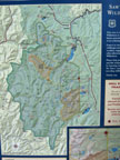 Big Map |
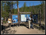 Wilderness Boundary |
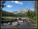 Hell Roaring Lake |
 Background Peak |
 Peaks Behind Lake |
 Finger Of Fate |
 Finger Close Up |
 Between Lakes |
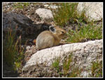 Pika |
 Tarn |
 Imogene Outlet |
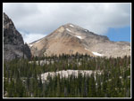 Mt. Cramer |
 Imogene Lake |
 Imogene Pass |
 Tarn Reflection |
 Cooler |
 Cooler Lake |
 Scrambling Up |
 Waterfall |
 Boulder Hopping |
 Boulder Break |
 Small Falls |
 Cramer Over Lake 8733 |
 Campsite |
 Close By Peaks |
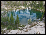 Reflection In Tarn |
 Puffy Clouds |
 Indian Paintbrush |
 Lake 8733 |
 Imogene Peak |
 Sunset On Peaks |
Day 2
Trips - 2009
Home