6-26-10
Time for a solo
trip. Where to go? Looking on the WTA site the night before I saw a
report by wolfwoman for Glacier Basin near Monte Cristo. I last
visited on October 28, 2006, just before the bridge
to Monte Cristo was washed out again. It had been more than a decade
since I visited in early summer. I cruised through Granite Falls and
arrived at Barlow Pass at 9:15 am. There was only one other car in the
lot along the road. One hiker was just starting out. 10 minutes later I
was on the trail/road. Just before the washout is the trailhead sign.
It used to be near the gate at the start.
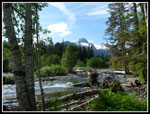
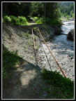
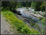
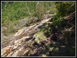
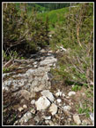
The sign suggests taking a path that climbs above the washout. It also mentions a dangerous trail across the washout. I recall previous washouts where wet orange clay made crossing tough. I chose to take the high road and check out the washout on my way back. Other than some extra elevation gain the reroute works fine. Soon after I reached the river. The first bridge is still there but the old shore is not. I knew that there is now a log that crosses the river.
The signs guide you onto the Gothic Basin Trail a short way and a signed trail drops down to the river. I passed the one hiker seen earlier not to see him again this day. The log is plenty wide and the river is fast and loud. That's the part that can spook folks. Another log just downstream would not be helpful in one fell in. Across the log I went left and ended up on the road near the first bridge. On the way back I found the trail just off to the right that comes out on the road next to the second bridge. That bridge is in fine shape. I was soon back on route.
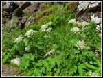
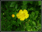
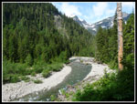
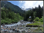
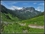
The theme for the day was set early and often. The road is lined with blooming columbine. Hundreds of them. Add in many buttercups and spring beauty and there was plenty of color. I also saw many false solomon's seal and a few queens cup flowers. The road goes fast as it gains elevation slowly with a few short hills. I passed one more group along the road. With flower stops and the log crossing I took longer than normal to cover the 4 miles to the town site. Last visit was 66 minutes each way. This time it was about 80 minutes getting me to town at 10:45. My morning drive was cloudy but the hiking was in the sun. It was warm and bright at Monte Cristo.
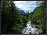
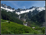
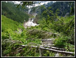
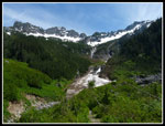
I headed up Dumas Street and onto the trail to Glacier Basin. At the trailhead I signed in and was surprised to see so many others had hiked up the trail so far this year. There are a few trees down but none are hard to get around. A few new flowers, including thistles, showed up after leaving the forest. The Glacier Creek Falls came into view and other falls coming down from the high ridges above. There is a big chunk of snow below the falls but none other at that elevation.
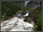
Just before the falls a landslide took out the trail and all the slope below it. A path cuts along the top. Not very hard to get by. I stopped at the waterfall for a break. This spot is worth the 5 miles of hiked needed to get there. Great views down the valley and up to the falls. The next part is the most interesting. The trail is just a scramble up wet slabs in a trench. I found a hand line here for the first time on my 2006 visit. There is still one in place. Not necessary but it does make it easier. The steepest part was not as long as I recalled. After about 120 vertical feet the grade lessened a little.
There is a tree down in the trench that must be climbed over. It also has the Henry Jackson Wilderness sign on it. The sign is face down and won't come out easily. I was glad to see that the snow has been melting quickly. There were a few patches of snow that could be avoided and solid snow did not begin until the trail begins to descend to the creek. Here I found old steps heading down. The snow is thin and covers a talus field. I was leery about falling through and took small steps testing each one. It was tedious but worked with a few deep post holes. I followed the creek with a number of short climbs on snow to avoid vertical snow walls right up to the creek.
I could see that this would only get worse ahead. Steps crossed the creek at a narrow point and continued up the valley on the other side. I wanted to stay on this side and chose not to follow. I decided to head higher where the snow was deeper. I scramble up rocks and reached the upper trail where it was bare. This was helpful. The route was soon under snow but I did a level traverse across the snow. The top 4-5 inches was slushy making it necessary to kick steps in several times to keep them from breaking out. Slow but safe was the idea as I was solo on steep snow.
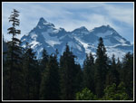
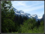
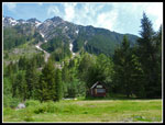
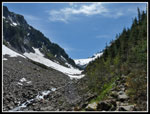
Back in forest I was back on dirt and followed trail through rocks and heather to where I usually take a break alongside Glacier Creek. What a beautiful place! Monte Cristo Peak sits at the end of the valley. The floor of the valley is still snow covered. The creek is pretty high. It was now 12:45 and past time for lunch. The sun was warm, there was almost no wind, and the rock was pretty comfortable. I took a short nap. I soon went a little farther. Following the creek I found a spot where I could rock hop across.
I slogged across snow to a some big flat slabs. A perfect place to... take another nap. Stunning views in all directions, when I could keep my eyes open. It took 6 1/2 miles but I was all alone in this big snowy bowl with steep walls all around. I heard both marmots and pikas but did not see any. I spent 1 3/4 hours in the basin and it was not long enough. This place will be full of people in a month. Wildflowers will cover the basin with braided streams all around. Beautiful then but even better now and without the crowds.
At 2:30 I packed up and headed out. I followed my steps back and then stayed on the upper trail. When it disappeared I headed down slope on snow and ended up dropping back to the spot where I first started on snow. There were no other prints on my in or out routes. I was all alone in the basin this day. Dropping down the rutted "trail" back to the falls is a knee banger but not too tough. The hand line was even more helpful coming down. I had to stop at the falls again. I don't think I have ever not done so.
Back at Monte Cristo my solitude went away. There were a number of groups at the town site. Hiking out on the road I passed more than half a dozen groups coming in. I made good time until I reached the log over the river. A backpacker was not having fun with the crossing. I must have spent 5 minutes as that person was coached across. Stopping is a lot harder than just continuing to move across. The last mile went fast and I was back at my car by 5:30. Even with a lot of photo stops it took only three hours to hike out the 6 1/2 miles.
What a great day in the mountains! I saw nobody above Monte Cristo. The sky was as blue as it gets and contrasted against the white snow it was spectacular. Waterfalls are everywhere and the sound of roaring water was constant. I even managed to get in a few short naps. This was the spring scramble I had so few of this year, even if it was in the summer.
Click on thumbnails to get larger pictures.
Photo Page 2
Trips - 2010
Home
The sign suggests taking a path that climbs above the washout. It also mentions a dangerous trail across the washout. I recall previous washouts where wet orange clay made crossing tough. I chose to take the high road and check out the washout on my way back. Other than some extra elevation gain the reroute works fine. Soon after I reached the river. The first bridge is still there but the old shore is not. I knew that there is now a log that crosses the river.
The signs guide you onto the Gothic Basin Trail a short way and a signed trail drops down to the river. I passed the one hiker seen earlier not to see him again this day. The log is plenty wide and the river is fast and loud. That's the part that can spook folks. Another log just downstream would not be helpful in one fell in. Across the log I went left and ended up on the road near the first bridge. On the way back I found the trail just off to the right that comes out on the road next to the second bridge. That bridge is in fine shape. I was soon back on route.
The theme for the day was set early and often. The road is lined with blooming columbine. Hundreds of them. Add in many buttercups and spring beauty and there was plenty of color. I also saw many false solomon's seal and a few queens cup flowers. The road goes fast as it gains elevation slowly with a few short hills. I passed one more group along the road. With flower stops and the log crossing I took longer than normal to cover the 4 miles to the town site. Last visit was 66 minutes each way. This time it was about 80 minutes getting me to town at 10:45. My morning drive was cloudy but the hiking was in the sun. It was warm and bright at Monte Cristo.
I headed up Dumas Street and onto the trail to Glacier Basin. At the trailhead I signed in and was surprised to see so many others had hiked up the trail so far this year. There are a few trees down but none are hard to get around. A few new flowers, including thistles, showed up after leaving the forest. The Glacier Creek Falls came into view and other falls coming down from the high ridges above. There is a big chunk of snow below the falls but none other at that elevation.
Just before the falls a landslide took out the trail and all the slope below it. A path cuts along the top. Not very hard to get by. I stopped at the waterfall for a break. This spot is worth the 5 miles of hiked needed to get there. Great views down the valley and up to the falls. The next part is the most interesting. The trail is just a scramble up wet slabs in a trench. I found a hand line here for the first time on my 2006 visit. There is still one in place. Not necessary but it does make it easier. The steepest part was not as long as I recalled. After about 120 vertical feet the grade lessened a little.
There is a tree down in the trench that must be climbed over. It also has the Henry Jackson Wilderness sign on it. The sign is face down and won't come out easily. I was glad to see that the snow has been melting quickly. There were a few patches of snow that could be avoided and solid snow did not begin until the trail begins to descend to the creek. Here I found old steps heading down. The snow is thin and covers a talus field. I was leery about falling through and took small steps testing each one. It was tedious but worked with a few deep post holes. I followed the creek with a number of short climbs on snow to avoid vertical snow walls right up to the creek.
I could see that this would only get worse ahead. Steps crossed the creek at a narrow point and continued up the valley on the other side. I wanted to stay on this side and chose not to follow. I decided to head higher where the snow was deeper. I scramble up rocks and reached the upper trail where it was bare. This was helpful. The route was soon under snow but I did a level traverse across the snow. The top 4-5 inches was slushy making it necessary to kick steps in several times to keep them from breaking out. Slow but safe was the idea as I was solo on steep snow.
Back in forest I was back on dirt and followed trail through rocks and heather to where I usually take a break alongside Glacier Creek. What a beautiful place! Monte Cristo Peak sits at the end of the valley. The floor of the valley is still snow covered. The creek is pretty high. It was now 12:45 and past time for lunch. The sun was warm, there was almost no wind, and the rock was pretty comfortable. I took a short nap. I soon went a little farther. Following the creek I found a spot where I could rock hop across.
I slogged across snow to a some big flat slabs. A perfect place to... take another nap. Stunning views in all directions, when I could keep my eyes open. It took 6 1/2 miles but I was all alone in this big snowy bowl with steep walls all around. I heard both marmots and pikas but did not see any. I spent 1 3/4 hours in the basin and it was not long enough. This place will be full of people in a month. Wildflowers will cover the basin with braided streams all around. Beautiful then but even better now and without the crowds.
At 2:30 I packed up and headed out. I followed my steps back and then stayed on the upper trail. When it disappeared I headed down slope on snow and ended up dropping back to the spot where I first started on snow. There were no other prints on my in or out routes. I was all alone in the basin this day. Dropping down the rutted "trail" back to the falls is a knee banger but not too tough. The hand line was even more helpful coming down. I had to stop at the falls again. I don't think I have ever not done so.
Back at Monte Cristo my solitude went away. There were a number of groups at the town site. Hiking out on the road I passed more than half a dozen groups coming in. I made good time until I reached the log over the river. A backpacker was not having fun with the crossing. I must have spent 5 minutes as that person was coached across. Stopping is a lot harder than just continuing to move across. The last mile went fast and I was back at my car by 5:30. Even with a lot of photo stops it took only three hours to hike out the 6 1/2 miles.
What a great day in the mountains! I saw nobody above Monte Cristo. The sky was as blue as it gets and contrasted against the white snow it was spectacular. Waterfalls are everywhere and the sound of roaring water was constant. I even managed to get in a few short naps. This was the spring scramble I had so few of this year, even if it was in the summer.
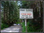 Extreme Danger |
 Wildflowers |
 Buttercup |
 Mountain View |
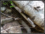
 Old Crossing |
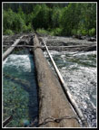 New Crossing |
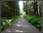 Road Walk |
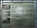 Weden House |
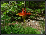 Columbine |
 Sauk River |
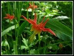 Columbine Close Up |
 Old Tracks |
 Yellow Border |
 Peaks Near Town |
 View From Bridge |
 Monte Cristo |
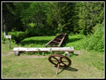 RR Turntable |
 Old Building |
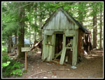 Peabody Garage |
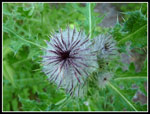 Thistle |
 Peaks & Falls |
 Down Trees |
 Snow Below Falls |
 Closer Look At Falls |
 Looking Down Valley |
 Trail Slid |
 Hand Line |
 Rocky Trail |
 Wilderness Sign |
 First Look At Basin |
Photo Page 2
Trips - 2010
Home