12-12-10
Four years later
we had a significant early accumulation of snow followed by a very warm
and big storm. Lots of flooding was in the works. I chose to make
another visit to the South Fork Stillaguamish River. The weather report
stated that the crest would be at around 4:00 pm at the gaging station
down river. I arrived at the Old Robe trailhead at 12:30. There were
only two other cars. One guy just returned and two folks headed out and
came back a few minutes later. Looked like I had the place to myself.
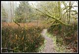
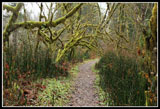
The rain had slowed though it never did stop. The trail switches back a
few times while descending to the flats below.
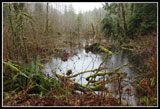
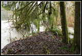
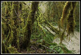
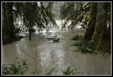
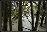
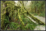
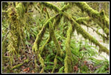
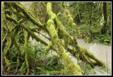
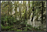
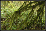
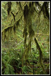
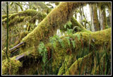
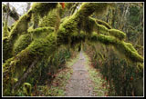
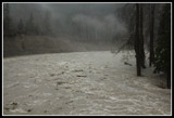
There is a lot of moss hanging off most of the trees and the rain and overcast sky really brought out the green color. The water level looked to be at or a little below the 2006 level. Still high enough to be flowing inland as the river was higher than the land. I made it to the same point I reached 4 years earlier. Water to the right, to the left, and straight ahead. No chance of continuing on towards the canyon. One of these days I'll get back there during a flood. Not this year though.
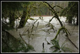
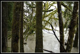
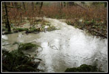
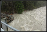
There is no way to get right to the edge of the river and look up and downstream. I had to be happy with views through the trees. Speaking of trees a number of big ones sailed on by, carried by the muddy brown churning river. The noise is constant though much less than in the canyon. You can really feel the power of the river when it's so big and out of control. I backtracked to a short trail to a picnic table near the current edge of the river. In summer it would be well inland. The trail was under water but I slogged through wet brush and sticker bushes to get to the table. The land from there is just too wet and muddy to go any father. The view was no better as trees and brush blocked the way.
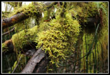
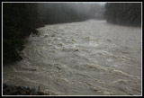
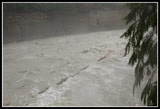
I took more time enjoying all the bright green moss then headed back to my car. The rain was picking up and I decided to head on down to the Pilchuck Bridge. I didn't have to worry about finding somewhere to park as the bridge was closed just as in 2006. This time the approach was not damaged. The water level was close to 2006 levels. I tried movies and photos. The movies did not turn out very good. The photos have some water smudges but do a pretty good job of depicting the power of the river.
Water was flowing through forest well above the normal bed of the river. Trees passed on by continuously. People kept arriving to have a look. The rain was now coming down even harder. Tough to keep a camera dry, even with an umbrella. It was 2:30 when I called it quits. I'm sure in a few years there will be another flood just like these. I'll probably come back and add to my documentation. I already have 20 years of floods on the South Fork Stillaguamish.
There is a lot of moss hanging off most of the trees and the rain and overcast sky really brought out the green color. The water level looked to be at or a little below the 2006 level. Still high enough to be flowing inland as the river was higher than the land. I made it to the same point I reached 4 years earlier. Water to the right, to the left, and straight ahead. No chance of continuing on towards the canyon. One of these days I'll get back there during a flood. Not this year though.
There is no way to get right to the edge of the river and look up and downstream. I had to be happy with views through the trees. Speaking of trees a number of big ones sailed on by, carried by the muddy brown churning river. The noise is constant though much less than in the canyon. You can really feel the power of the river when it's so big and out of control. I backtracked to a short trail to a picnic table near the current edge of the river. In summer it would be well inland. The trail was under water but I slogged through wet brush and sticker bushes to get to the table. The land from there is just too wet and muddy to go any father. The view was no better as trees and brush blocked the way.
I took more time enjoying all the bright green moss then headed back to my car. The rain was picking up and I decided to head on down to the Pilchuck Bridge. I didn't have to worry about finding somewhere to park as the bridge was closed just as in 2006. This time the approach was not damaged. The water level was close to 2006 levels. I tried movies and photos. The movies did not turn out very good. The photos have some water smudges but do a pretty good job of depicting the power of the river.
Water was flowing through forest well above the normal bed of the river. Trees passed on by continuously. People kept arriving to have a look. The rain was now coming down even harder. Tough to keep a camera dry, even with an umbrella. It was 2:30 when I called it quits. I'm sure in a few years there will be another flood just like these. I'll probably come back and add to my documentation. I already have 20 years of floods on the South Fork Stillaguamish.
 Pond |
 Reedy Trail |
 First Look At River |
 Inundated Trees |
 End Of The Trail |
 River Running Inland |
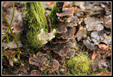 Turkey Tail Fungus |
 Amazon Rainforest |
 Murky Water |
 Looking Up River |
 Route Is Ahead |
 Shades Of Green |
 Jungle |
 River's Edge |
 Great Photo Conditions |
 Hanging Moss |
 Ferns |
 More Moss |
 Tall Reeds |
 Mossy Arch |
 From Pilchuck Bridge |
 Dark Churning Water |
 View Downstream |
 One Of Many Logs |
Click on thumbnails to get larger
pictures.
<< Photo Page
Wild Stillaguamish Report
Trips - 2010
Home
<< Photo Page
Wild Stillaguamish Report
Trips - 2010
Home