02-19-11
A
cold, clear, and sunny day for
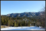
most of Washington state in February on a weekend? I had to get up high
and enjoy the view. Janet was looking for the same thing and we teamed
up for a trip to the east side of the Cascades. We met in Bellevue at
7:00 am and headed east. One stop in North Bend to pick up a Sno-Park
permit and another in Cle Elum when we realized that neither of us had
packed sun screen. Even with the stops we arrived at Blewett Pass just
after 9:00 am. There were already half a dozen cars in the small lot.
This is a snowmobile Sno-Park and there are always a lot of them there.
I have skied and/or snowshoed up on either side of Diamond Head but had
never been there. Another first time trip.
We planned to follow roads around the west side of Diamond Head then climb cross country up to another road that goes near the summit. The last part would be off road again. One can drop down the ridge to the saddle between Diamond Head and the next peak east (Diamond Tail) then follow a cross country ski route around the east side and back to the car. If conditions were good we could do the loop. If not we would return the way we came.
It was very cold at the start. My thermometer read 19 degrees with a little wind. As we headed up the road it became a bit warmer. Shade was cold but some sunny stretches felt much warmer. The road headed south right towards Diamond Head. It then turned to the right and continues a gradual ascent. We had a few groups of snowmobiles pass by then it was all quite once again. We came to an intersection that seemed to be too early. It was. Our GPSs confirmed we had a little farther to go.
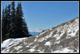
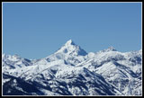
Some views opened up out to the Teanaway peaks and Mt. Stuart. Stuart was such a steep and narrow pyramid from this angle that I did not recognize it at first. At the next junction we turned to the left. We crossed over a creek and came to another smaller road to the left. This was our route. The road began to steepen. In a short distance it turned to the right and we continued straight ahead. This put us on a ridge that led up to the other road. It is not a really obvious ridge but it helped us navigate up the slope.
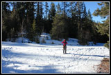
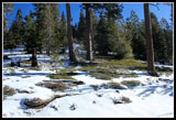
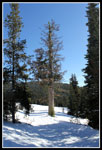
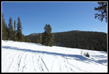
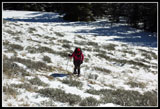
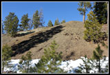
A short easy walk through forest brought us to another road that was not on my GPS map. Up to this point we were booting it but it was finally time to put on snowshoes. There is precious little snow near Blewett Pass for mid winter. The snowmobile road was groomed flat but only a few inches deep in places. Some of the south facing slopes were completely bare. Now off road and in the forest we had a foot or two of snow. Not much but enough to make use of our snowshoes.
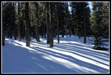
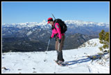
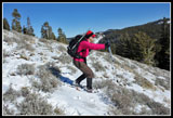
Once across the road the grade became steeper. It was never all that steep as our ice axes never left our packs. The lack of snow meant we had to wind around downed trees as we moved higher. There are places on either side of our route that went into densely packed smaller trees. We managed to find ways to stay on more open terrain. The snow conditions were pretty good for climbing. Nearly half the elevation we gained for the day was on this one mile or so off road section.
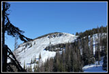
We popped back out onto the road about 300' below the top of Diamond Head. Walking up the road we had much better views to the peaks to the west. The whole Stuart Range was now visible though from our angle some Teanaway peaks in the foreground hid all but the tops of the higher Stuart Range summits. After nearly four miles of walking we came to a road sign. Not something I usually see that far from the trailhead. Five miles to Lion Rock and 27 miles to Ellensburg. We followed the road just over the crest of the ridge and left forest. It was still cold and being out in the sun felt great.
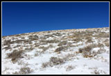
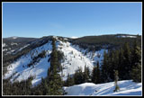
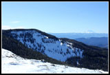
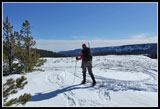
Millions of snowmobile tracks here and a few snowmobiles too. We headed back to the ridge crest and the last short gain to the top of Diamond Head. It is not very far from the road to the high point. High point is almost a misnomer as the top is a long flat plateau. We followed a snowmobile track through forest and came out at the base of a slope of thin snow and sagebrush. First time I have ever climbed a sagebrush covered slope with snowshoes. At the top it was flat with great views to the southwest through northwest. Even Mt. Rainier was in sight with not a cloud around it.
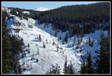
We took a short break there then headed back into forest. We found an older snowshoe track here. It was covered by recent snow but was still just visible. When the grade began to descend Janet chose to had back to the open spot for lunch. I went a little farther and came to a viewpoint to the north. I could see down to the saddle to the north and the gully where the ski trail heads back to the car. The rocky gully does not have much snow in it. It did not look like much fun to descend. At this viewpoint I was hit by a steady 15 mph wind. With the temperature still only in the low 20s it was frigid. My stay was very short.
I soon caught up with Janet and we had lunch at the open area. Great views and very little wind. We saw no snowmobiles off road this day. Without the wind it was pleasant sitting in the sunshine. All too soon we packed up and headed back. I told Janet about what I could see of the route for the loop and we chose to retrace our route up. It was 4.4 miles to my turn around spot at the north viewpoint. We quickly dropped to the road and then to the point where we came out of the forest. GPS was very helpful as we walked by this point at first.
Descending the steeper slope was no problem. Footing was good. Soon we were back on the lower road. We did have a few groups of snowmobiles pass us coming back but all in all they were not a problem at any time on this trip. All the riders were very courteous. We reached the car at 3:05 pm. This was a very nice trip to some great views. Other than the snowmobiles we saw no snowshoers and three skiers. Total elevation gain was about 1900' over 4.4 miles. Not a steep trip. Good company, good weather, and great views. Hard to ask for more. A fine day on the sunny side of the mountains.
Click on thumbnails to get
larger pictures.
Trips - 2011
Home
We planned to follow roads around the west side of Diamond Head then climb cross country up to another road that goes near the summit. The last part would be off road again. One can drop down the ridge to the saddle between Diamond Head and the next peak east (Diamond Tail) then follow a cross country ski route around the east side and back to the car. If conditions were good we could do the loop. If not we would return the way we came.
It was very cold at the start. My thermometer read 19 degrees with a little wind. As we headed up the road it became a bit warmer. Shade was cold but some sunny stretches felt much warmer. The road headed south right towards Diamond Head. It then turned to the right and continues a gradual ascent. We had a few groups of snowmobiles pass by then it was all quite once again. We came to an intersection that seemed to be too early. It was. Our GPSs confirmed we had a little farther to go.
Some views opened up out to the Teanaway peaks and Mt. Stuart. Stuart was such a steep and narrow pyramid from this angle that I did not recognize it at first. At the next junction we turned to the left. We crossed over a creek and came to another smaller road to the left. This was our route. The road began to steepen. In a short distance it turned to the right and we continued straight ahead. This put us on a ridge that led up to the other road. It is not a really obvious ridge but it helped us navigate up the slope.
A short easy walk through forest brought us to another road that was not on my GPS map. Up to this point we were booting it but it was finally time to put on snowshoes. There is precious little snow near Blewett Pass for mid winter. The snowmobile road was groomed flat but only a few inches deep in places. Some of the south facing slopes were completely bare. Now off road and in the forest we had a foot or two of snow. Not much but enough to make use of our snowshoes.
Once across the road the grade became steeper. It was never all that steep as our ice axes never left our packs. The lack of snow meant we had to wind around downed trees as we moved higher. There are places on either side of our route that went into densely packed smaller trees. We managed to find ways to stay on more open terrain. The snow conditions were pretty good for climbing. Nearly half the elevation we gained for the day was on this one mile or so off road section.
We popped back out onto the road about 300' below the top of Diamond Head. Walking up the road we had much better views to the peaks to the west. The whole Stuart Range was now visible though from our angle some Teanaway peaks in the foreground hid all but the tops of the higher Stuart Range summits. After nearly four miles of walking we came to a road sign. Not something I usually see that far from the trailhead. Five miles to Lion Rock and 27 miles to Ellensburg. We followed the road just over the crest of the ridge and left forest. It was still cold and being out in the sun felt great.
Millions of snowmobile tracks here and a few snowmobiles too. We headed back to the ridge crest and the last short gain to the top of Diamond Head. It is not very far from the road to the high point. High point is almost a misnomer as the top is a long flat plateau. We followed a snowmobile track through forest and came out at the base of a slope of thin snow and sagebrush. First time I have ever climbed a sagebrush covered slope with snowshoes. At the top it was flat with great views to the southwest through northwest. Even Mt. Rainier was in sight with not a cloud around it.
We took a short break there then headed back into forest. We found an older snowshoe track here. It was covered by recent snow but was still just visible. When the grade began to descend Janet chose to had back to the open spot for lunch. I went a little farther and came to a viewpoint to the north. I could see down to the saddle to the north and the gully where the ski trail heads back to the car. The rocky gully does not have much snow in it. It did not look like much fun to descend. At this viewpoint I was hit by a steady 15 mph wind. With the temperature still only in the low 20s it was frigid. My stay was very short.
I soon caught up with Janet and we had lunch at the open area. Great views and very little wind. We saw no snowmobiles off road this day. Without the wind it was pleasant sitting in the sunshine. All too soon we packed up and headed back. I told Janet about what I could see of the route for the loop and we chose to retrace our route up. It was 4.4 miles to my turn around spot at the north viewpoint. We quickly dropped to the road and then to the point where we came out of the forest. GPS was very helpful as we walked by this point at first.
Descending the steeper slope was no problem. Footing was good. Soon we were back on the lower road. We did have a few groups of snowmobiles pass us coming back but all in all they were not a problem at any time on this trip. All the riders were very courteous. We reached the car at 3:05 pm. This was a very nice trip to some great views. Other than the snowmobiles we saw no snowshoers and three skiers. Total elevation gain was about 1900' over 4.4 miles. Not a steep trip. Good company, good weather, and great views. Hard to ask for more. A fine day on the sunny side of the mountains.
 First Views |
 Left At The Junction |
 Not Much Snow |
 Off Road At Last |
 Nearing Diamond Head |
 Big Old Larch Tree |
 Sunny Meadow |
 Thin Snow Over Sage |
 Framed Mt. Rainier |
 Janet Climbs Up |
 Northern Viewpoint |
 Rocks Showing Through |
 Mt. Stuart & Teanaway |
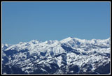 More Teanaway Peaks |
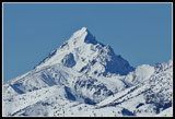 Mt. Stuart Close Up |
 View South |
 Janet Goes Airborne |
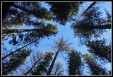
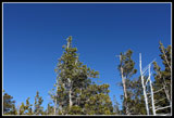 Sky & Pines |
 Lunch Spot |
 Janet Glissaging |
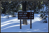 Road Signs |
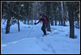 Janet Descending |
 Trees & The Sky |
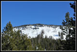 Look At Diamond Head |
 Bare Hillside |
Trips - 2011
Home