9/14-16/12
I
had wondered about the old trail
from the Suiattle Road to the parking lot for the Green Mountain Trail.
In 2009 Kim and Randy joined me for a hike on trail abandoned some half
century ago. The Suiattle Road washed out in 2006 and the only other
access was to bike or hike seven miles of the Suiattle Road and then
take the Green Mountain Road another six miles and nearly 2000' to the
parking lot. Our route was much more interesting. We were somewhat
surprised to be able to follow the old trail though with a few
missteps. I knew Gary would love this old route. Three years later he
joined me for another trip.
Day 1 - Biking Approach
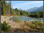
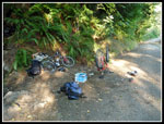
We met in Seattle at 1:30 and headed north. Through Arlington and Darrington then north to the Suiattle River Road. Much of the paved section has been recently oiled and graveled and the new layer is in great shape though with a few loose bits of gravel that have not packed down yet. Much smoother now. The dirt section was awful this spring but it too has been graded and is fine to drive. We arrived at Mile 12.5, the current road end, at about 4:05 pm. Much to my surprise there were nearly a dozen cars already there. It is about 8 1/2 miles to the campsites at Downey Creek. We hefted backpacks and headed up the road. It was still quite hot and the heat plus consistent uphill made for slow biking. It became even slower. at 1.9 miles in I went over a sharp rock and pierced my outer and inner tubes. Not an auspicious beginning. It took the better part of half an hour to get a new tube on and pumped up. My first flat on my mountain bike.
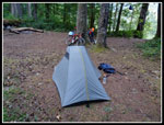
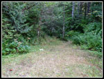
We still had plenty of time to get to camp before dark. A little after 6:00 pm we reached Downey Creek and our camp just on the other side. We saw a number of bikers and hikers on the road but nobody else at the camp. We set up camp, filtered water, and found the start of the old Green Mountain Trail just before the bridge. After dinner we watched the sun set and headed to bed. It was very hazy with smoke from eastern Washington fires blowing to the west. We had a warm night at only 1450'.
Day 2 - Ascending Green Mountain
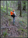
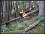
We were up at 7:00 am and on our way by 8:30 am. Back across Downey Creek and to the grassy spot. A trail takes off following Downey Creek and another heads more uphill. We took the uphill one. In 25 feet the trail turns up the creek and soon ends. The Green Mountain Trail goes that 25 feet then continues up the slope. It is faint at the bottom but becomes more obvious quickly. Several trees have fallen here since my 2009 hike. One is an easy step across. The next one is huge and right on the trail. We got onto the tree to get a better view. About 2/3rds of the way along this tree the trail makes a sharp left and goes away from the tree. This is faint at first but is soon more obvious.
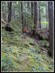
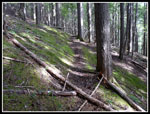
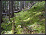
This trail is not for the faint of heart. It has some very clear segments and is very faint in other places. In a few spots several trees have obscured it. Patience is needed if the route is lost. It is still there all the way up. On the earlier trip we lost it going up and down in the same spot before finding it again. This time we did much better. We had no mistakes all the way up. I had a mapless GPS on the first trip but a much better one this time. Laying in the correct route going up made the descent much easier. There are dozens of trees down across the route. That is to be expected. Only a few required us to have both feet off the ground as we pulled ourselves over. The amazing thing is that for the whole two plus miles of the trail there are no creek crossings. No water damage to the route at all. It is also through old growth forest. Some huge trees and it is dark with little ground cover. That helps explain how the trail is still there after 50 years with no maintenance.
With the downed trees and numerous spots where close inspection is necessary to stay on route this is not a fast trail to hike. We managed one mile per hour. It is a well thought out trail. They did not use any dynamite when this trail was built. It switchbacks were necessary to avoid cliffs. It works it's way methodically up the slope. Unlike many old lookout trails it is never very steep. Just lots of short switchbacks and longer traverses. While the Green Mountain Road requires about six miles to reach the upper trailhead this trail climbs from Suiattle Road in just over two miles. The dark forest proves a good environment for saprophyte plants. Those that do not have chlorophyll and so have no green color. We saw many on our late June hike. This day they were still there but faded and not very colorful.
My memory helped us in the middle as the trail seems to disappear. I recalled it switchbacked to the right in moss and salal. We immediately found it. Near the road the trail fades out for good. Trees were cut below the road and the trail seems to have been obliterated. We just continued straight ahead to the road. We put a cairn to help on the return. Just a short way down the road is a clear cut. Our route just missed it. We turned right and followed the road a short distance to the current trailhead. In just six years since the road was washed out the lot has turned to grass. Hopefully the Suiattle Road will be repaired next year and this crown jewel of a hike will be returned to hikes to enjoy without 34 miles to bike and hike.
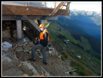
This day was the first day of the high hunt. It includes the Glacier Peak Wilderness. Though we did not expect to see anyone we had on lots of orange. Just as we did not expect to see a hunter it was likely hunters would not expect to see a hiker way up here. A little caution goes a long way. We checked the sign in and found that 12 other parties had signed in this year. With the road functioning that would represent less than half of any summer weekend day at Green Mountain. It was fun to have it to ourselves but I will like it more when many hikers can enjoy this beautiful trip once again. We also found a wheeled litter and a gun case which alerted us that we might not be alone after all. In 2009 there were two good sized logs blocking the Green Mountain Trail. They have been completely removed. No problems hiking in the forest.
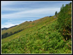
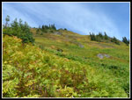
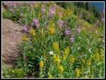
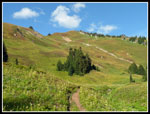
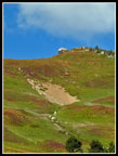
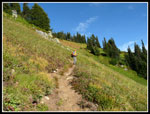
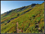
Once out of the forest we began to climb the many gentle switchbacks leading up the slope. Here the lack of hikers and trail crews really shows. In places the brush is now head high (I'm 6'4") and across the trail. We had to be careful of marmot holes since we could not see our feet at times. It just needs a good brushing. Not all the green slopes are brushy. Some of the trail is just fine. For now if there is rain or dew you will get soaked. Bring rain gear. There are a few spots where the trail is sliding but I did not notice it to be any worse over the last three years. We did not find any berries along the trail but a view uphill showed there are some thick patches of ripe berries. The bears should do okay this season.
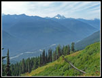
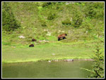
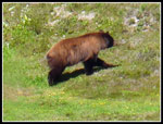
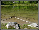
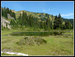
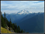
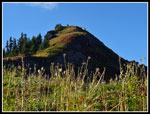
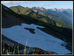
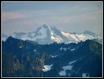
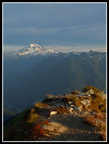
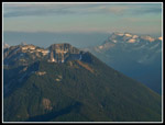
The trail rounds the bend into forest for a final climb to the high point. A hazy Glacier Peak came into view as well as the Green Mountain lookout in the other direction. We dropped down to a big tarn/small lake. As we descended Gary noticed bears along the shore. It was a cinnamon colored mother with two small cubs. My first bear sighting in about five years. They seemed to get wind of us and headed up a boulder field, over a ridge, and out of sight. We took two hours to hike the old trail and another two hours to reach the lake. At 5200' we were 1300' below the lookout. It was warm and not too buggy. A check turned up three close by campsites. We chose one with easy water access and set up camp.
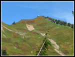
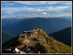
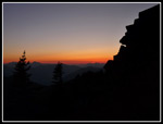
Our plan now was to take a break then head to the lookout for dinner and sunset. By 4:30 pm we headed up. Surprisingly, a few minutes later our camp was in the dark. Victim of a high ridge. by heading up we managed to get in almost three more hours of sunshine. The trail up is in fine shape. Not very overgrown yet. We spotted one marmot on a rock and heard several more. It is 1.1 miles to reach the 6500' summit. As we neared the ridge I spotted an orange hat just at eye level above the ridge. A head and rifle barrel followed. The only person we would see was a hunter. We were even more glad now for wearing orange. I doubt the hunter expected to see any hikers up there. A quick wave completed our interaction. We never did meet him. At 5:20 we reached the summit lookout, just about two hours before sunset.
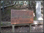
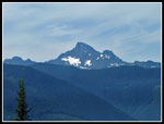
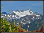
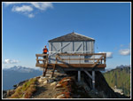
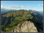
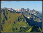
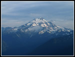
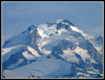
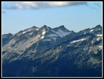
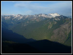
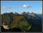
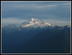
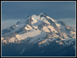
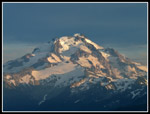
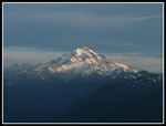
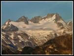
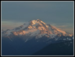
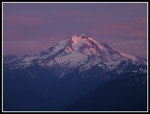
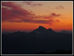
The lookout is in great shape. In my opinion it will be a shame if the order to tear it down in carried out. The foundation was the main problem and it is now very sturdy. A big belt has been cinched around the its mid section clamping the shutters closed. It is locked up tight as well. I would have loved to spend a night there. The afternoon haze had lessened. There was a little smoke from the fires east of the crest but mostly blue sky. The view is absolutely among the best in the northern Cascades. Certainly for a trail hike. Glacier Peak is right in your face. Two weeks earlier we backpacked on the south side. The sunny rocky side. The north side is very much coated in ice. To the south we could see Whitechuck, Pugh, and Sloan Peaks. Three Fingers and Whitehorse were more westerly. The big glacier on Dome Peak was right in our sights. Farther out we could spot Bonanza, Buck, and Seven Fingered Jack. To the north were Snowking, Chaval, and even Mt. Baker. Green Mountain is a fantastic spot to see the beauty of the northern Cascades.
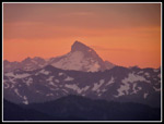
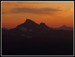
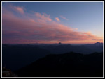
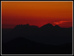
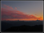
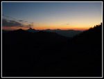
A hot dinner was appreciated then we sat down for the sunset show. The smoke provided some great colors. Sloan, Pugh, and Whitechuck stood out better than during the day. All the effort to get up there was more than worth it. The sun had set by 7:25 pm and we were heading down soon after. We made it most of the way before stopping to pull out headlamps for the final bit. By 8:30 pm we were ready for bed.
Click on thumbnails to get
larger pictures.
Day 3
Trips - 2012
Home
Day 1 - Biking Approach
We met in Seattle at 1:30 and headed north. Through Arlington and Darrington then north to the Suiattle River Road. Much of the paved section has been recently oiled and graveled and the new layer is in great shape though with a few loose bits of gravel that have not packed down yet. Much smoother now. The dirt section was awful this spring but it too has been graded and is fine to drive. We arrived at Mile 12.5, the current road end, at about 4:05 pm. Much to my surprise there were nearly a dozen cars already there. It is about 8 1/2 miles to the campsites at Downey Creek. We hefted backpacks and headed up the road. It was still quite hot and the heat plus consistent uphill made for slow biking. It became even slower. at 1.9 miles in I went over a sharp rock and pierced my outer and inner tubes. Not an auspicious beginning. It took the better part of half an hour to get a new tube on and pumped up. My first flat on my mountain bike.
We still had plenty of time to get to camp before dark. A little after 6:00 pm we reached Downey Creek and our camp just on the other side. We saw a number of bikers and hikers on the road but nobody else at the camp. We set up camp, filtered water, and found the start of the old Green Mountain Trail just before the bridge. After dinner we watched the sun set and headed to bed. It was very hazy with smoke from eastern Washington fires blowing to the west. We had a warm night at only 1450'.
Day 2 - Ascending Green Mountain
We were up at 7:00 am and on our way by 8:30 am. Back across Downey Creek and to the grassy spot. A trail takes off following Downey Creek and another heads more uphill. We took the uphill one. In 25 feet the trail turns up the creek and soon ends. The Green Mountain Trail goes that 25 feet then continues up the slope. It is faint at the bottom but becomes more obvious quickly. Several trees have fallen here since my 2009 hike. One is an easy step across. The next one is huge and right on the trail. We got onto the tree to get a better view. About 2/3rds of the way along this tree the trail makes a sharp left and goes away from the tree. This is faint at first but is soon more obvious.
This trail is not for the faint of heart. It has some very clear segments and is very faint in other places. In a few spots several trees have obscured it. Patience is needed if the route is lost. It is still there all the way up. On the earlier trip we lost it going up and down in the same spot before finding it again. This time we did much better. We had no mistakes all the way up. I had a mapless GPS on the first trip but a much better one this time. Laying in the correct route going up made the descent much easier. There are dozens of trees down across the route. That is to be expected. Only a few required us to have both feet off the ground as we pulled ourselves over. The amazing thing is that for the whole two plus miles of the trail there are no creek crossings. No water damage to the route at all. It is also through old growth forest. Some huge trees and it is dark with little ground cover. That helps explain how the trail is still there after 50 years with no maintenance.
With the downed trees and numerous spots where close inspection is necessary to stay on route this is not a fast trail to hike. We managed one mile per hour. It is a well thought out trail. They did not use any dynamite when this trail was built. It switchbacks were necessary to avoid cliffs. It works it's way methodically up the slope. Unlike many old lookout trails it is never very steep. Just lots of short switchbacks and longer traverses. While the Green Mountain Road requires about six miles to reach the upper trailhead this trail climbs from Suiattle Road in just over two miles. The dark forest proves a good environment for saprophyte plants. Those that do not have chlorophyll and so have no green color. We saw many on our late June hike. This day they were still there but faded and not very colorful.
My memory helped us in the middle as the trail seems to disappear. I recalled it switchbacked to the right in moss and salal. We immediately found it. Near the road the trail fades out for good. Trees were cut below the road and the trail seems to have been obliterated. We just continued straight ahead to the road. We put a cairn to help on the return. Just a short way down the road is a clear cut. Our route just missed it. We turned right and followed the road a short distance to the current trailhead. In just six years since the road was washed out the lot has turned to grass. Hopefully the Suiattle Road will be repaired next year and this crown jewel of a hike will be returned to hikes to enjoy without 34 miles to bike and hike.
This day was the first day of the high hunt. It includes the Glacier Peak Wilderness. Though we did not expect to see anyone we had on lots of orange. Just as we did not expect to see a hunter it was likely hunters would not expect to see a hiker way up here. A little caution goes a long way. We checked the sign in and found that 12 other parties had signed in this year. With the road functioning that would represent less than half of any summer weekend day at Green Mountain. It was fun to have it to ourselves but I will like it more when many hikers can enjoy this beautiful trip once again. We also found a wheeled litter and a gun case which alerted us that we might not be alone after all. In 2009 there were two good sized logs blocking the Green Mountain Trail. They have been completely removed. No problems hiking in the forest.
Once out of the forest we began to climb the many gentle switchbacks leading up the slope. Here the lack of hikers and trail crews really shows. In places the brush is now head high (I'm 6'4") and across the trail. We had to be careful of marmot holes since we could not see our feet at times. It just needs a good brushing. Not all the green slopes are brushy. Some of the trail is just fine. For now if there is rain or dew you will get soaked. Bring rain gear. There are a few spots where the trail is sliding but I did not notice it to be any worse over the last three years. We did not find any berries along the trail but a view uphill showed there are some thick patches of ripe berries. The bears should do okay this season.
The trail rounds the bend into forest for a final climb to the high point. A hazy Glacier Peak came into view as well as the Green Mountain lookout in the other direction. We dropped down to a big tarn/small lake. As we descended Gary noticed bears along the shore. It was a cinnamon colored mother with two small cubs. My first bear sighting in about five years. They seemed to get wind of us and headed up a boulder field, over a ridge, and out of sight. We took two hours to hike the old trail and another two hours to reach the lake. At 5200' we were 1300' below the lookout. It was warm and not too buggy. A check turned up three close by campsites. We chose one with easy water access and set up camp.
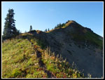
Our plan now was to take a break then head to the lookout for dinner and sunset. By 4:30 pm we headed up. Surprisingly, a few minutes later our camp was in the dark. Victim of a high ridge. by heading up we managed to get in almost three more hours of sunshine. The trail up is in fine shape. Not very overgrown yet. We spotted one marmot on a rock and heard several more. It is 1.1 miles to reach the 6500' summit. As we neared the ridge I spotted an orange hat just at eye level above the ridge. A head and rifle barrel followed. The only person we would see was a hunter. We were even more glad now for wearing orange. I doubt the hunter expected to see any hikers up there. A quick wave completed our interaction. We never did meet him. At 5:20 we reached the summit lookout, just about two hours before sunset.
The lookout is in great shape. In my opinion it will be a shame if the order to tear it down in carried out. The foundation was the main problem and it is now very sturdy. A big belt has been cinched around the its mid section clamping the shutters closed. It is locked up tight as well. I would have loved to spend a night there. The afternoon haze had lessened. There was a little smoke from the fires east of the crest but mostly blue sky. The view is absolutely among the best in the northern Cascades. Certainly for a trail hike. Glacier Peak is right in your face. Two weeks earlier we backpacked on the south side. The sunny rocky side. The north side is very much coated in ice. To the south we could see Whitechuck, Pugh, and Sloan Peaks. Three Fingers and Whitehorse were more westerly. The big glacier on Dome Peak was right in our sights. Farther out we could spot Bonanza, Buck, and Seven Fingered Jack. To the north were Snowking, Chaval, and even Mt. Baker. Green Mountain is a fantastic spot to see the beauty of the northern Cascades.
A hot dinner was appreciated then we sat down for the sunset show. The smoke provided some great colors. Sloan, Pugh, and Whitechuck stood out better than during the day. All the effort to get up there was more than worth it. The sun had set by 7:25 pm and we were heading down soon after. We made it most of the way before stopping to pull out headlamps for the final bit. By 8:30 pm we were ready for bed.
 Suiattle River |
 Flat Tire |
 Downey Creek Camp |
 Start Of Old Trail |
 Gary On Trail |
 Climbing Over Logs |
 Faint Trail |
 Wire Insulator |
 More Defined Trail |
 Mossy Trail |
 End Of The Old Trail |
 Lookout Restoration Sign |
 Whitechuck Mountain |
 Green Slopes |
 Goldenrod |
 A Little Fall Color |
 Down To The River |
 Fireweed & Goldenrod |
 First View Of Lookout |
 Bear Family |
 Mother Bear |
 Clear Lake |
 Lake & Summit |
 Heading For Summit |
 Summit Close Up |
 First Glacier Peak View |
 Trail Not Overgrown |
 Well Lit Slope |
 Dome Peak |
 Summit Ridge |
 Snow Below Summit |
 Sun & Shade |
 Green Mountain Lookout |
 View North |
 Contrasting Ridges |
 Glacier Lit Up |
 Glacier Close Up |
 View From Steps |
 Rugged Peaks |
 Ptarmigan Traverse |
 Dinner Time |
 Darkening Slopes |
 Black Mountain |
 Glacier Nearing Sunset |
 Light On Glaciers |
 Best Glacier Shot |
 Later Light |
 Summit Color |
 Sulphur & Buck Peaks |
 Dome Glacier |
 Yet Another Of Glacier |
 Sunset & Sloan Peak |
 Whitechuck Sunset |
 Pink Light |
 Blue Sky & Color |
 Really Colorful |
 Color To The SW |
 Whitechuck Again |
 Color & Rocky Ridge |
 Last Sunset Shot |
Day 3
Trips - 2012
Home