10-28-12
Kim
invited me to come along on
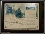
Solo Steve's annual Halloween Hike. The Iron Goat Trail is one I had
not yet hiked. Sign me up. By 9:30 am everyone had arrived at the
Martin
Creek Trailhead. The old railroad grade is right next to Highway 2
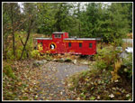
where the Old Cascade Highway meets the newer highway. There is a
trailhead and a caboose visible from Highway 2. The grade continues for
a little over 3 miles to the Martin Creek Trailhead. It switches back
and heads up to the abandoned tunnel under the Cascade Mountains. Our
route was to hike three miles back down to Scenic first. From there a
newer trail heads steeply uphill to meet the grade again about 6 miles
from Scenic and a little more than 3 miles from the Martin Creek
Trailhead. That uphill trail gains about 700' in just under a mile.
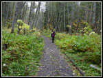
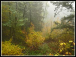
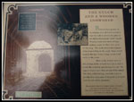
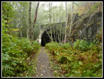
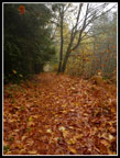
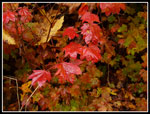
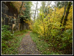
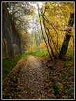
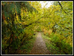
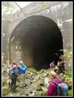
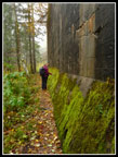
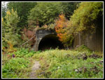
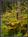
Once old acquaintances were renewed and new folks, like me, were introduced we were underway. There are a lot of deciduous trees along the grade. Great fall leaf colors. By the end of October many leaves had fallen already. this provided some good color on the trees and more on the grade itself. Being a railroad grade the descent was very gentle. The old grade had a number of tunnels and miles of snowsheds. The wooden sheds have long since collapsed or been taken down. All that remains is a tall cement wall along a good part of the hiking trail. There are numerous signs posted along the way to impart knowledge of the old route. Many of the old tunnels had "1914" and "1916" dates embedded in the cement. It has been nearly a century since they were built. The first tunnel was opened in 1900. The lower and longer current tunnel was opened in 1929. The old tunnel and route have been abandoned for 83 years.
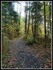
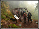
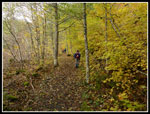
The first section of trail may have been the most photogenic. Lots of leaf color and plenty of old tunnels and sheds. The day started out cloudy. Cloudy as in we were walking in the clouds. The mist added to the mood. I was hiking alone at one point when I heard a pecking sound. A downey woodpecker was right above the trail. I managed half a dozen blurry photos as it would not sit still but did manage one acceptable shot. I caught up with most of the folks in our group at the Scenic Trailhead. Several big boards with lots of history provided. After a break we headed onward and upward. They newer connector trail takes hikers up to the Windy Point viewpoint in just 1 1/4 miles. Via the long gentle grade it would be five miles longer each way. With the shortcut it is now a reasonable day hike to get all the way to near the old tunnel.
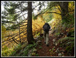
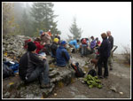
The shortcut has many short switchbacks as it climbs. It is not an overly steep trail. It is just very consistent as it climbs. It did not take long to reach the grade. We headed right for the last quarter mile to Windy Point. There is a toilet just off the trail that would provide quite a view on a clear day. I'll have to come back to see just how good. There was plenty of room for our whole group at Windy Point. The rain held off and the wind was very light. There was no view but the conditions were otherwise great for a long lunch break. Steve makes sure these hikes are well catered. There was plenty to eat and drink. A good time was had by all.
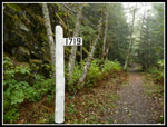
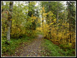
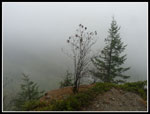
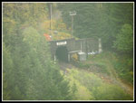
In time the clouds even parted, at least a little. The new tunnel entrance was now in view down below. Scenic and near the Surprise Lake trailhead were in site too. Although we were at 2900' there was no trace of the recent mountain snowfall. We could see some well above us to the south and east. I arrived at 12:20 pm and we stayed for nearly an hour. Our return route was on the upper grade back down to the Martin Creek trailhead. For the full 8 mile hike we had just under one mile uphill and all the rest downhill or flat. I stopped at most all the interpretive signs to learn more about the old grade. A little less leaf color on the upper grade but still some fine color.
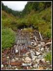
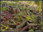
At one point there is a series of steps that lead up to the top of a snowshed wall. I followed the trail to a creek. Above that is an old wooden wall that contained a reservoir. The sign explained that water was impounded to help with fire fighting. The old pre diesel trains had a habit of kicking out embers that started fires. At this spot we ran into a group of half a dozen hikers. One of only a handful of hikers seen all day. I guess the dreary weather and late season kept folks at home. That was doubly enjoyed as we sailed along Highway 2 through Sultan with no slowdown on the way home.
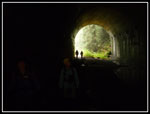
There are two crossover trails that drop down to the lower grade. The second one is the trail now. The old grade made a long turn to switch back down the valley. It is now buried under brush. The second crossover comes out very near the Martin Creek parking lot. I'll have to explore the switchback at a later date. I also would like to hike beyond Windy Point The grade goes on to Wellington, the site of the worst avalanche in American history. About 100 people perished when an avalanche swept a trail off the tracks and down the mountainside. The old tunnel is a little farther. The tunnel is not open to hikers.
I had a fun time finally hiking the Iron Goat Trail. My thanks go out to all the volunteers who have spent many hours reclaiming the grade and providing both a great hike and a history lesson. I will return as I have more to see farther down the trail. Also thanks to Steve and all the others who were on this hike. I had a great time.
Click on thumbnails to get
larger pictures.
Trips - 2012
Home
Once old acquaintances were renewed and new folks, like me, were introduced we were underway. There are a lot of deciduous trees along the grade. Great fall leaf colors. By the end of October many leaves had fallen already. this provided some good color on the trees and more on the grade itself. Being a railroad grade the descent was very gentle. The old grade had a number of tunnels and miles of snowsheds. The wooden sheds have long since collapsed or been taken down. All that remains is a tall cement wall along a good part of the hiking trail. There are numerous signs posted along the way to impart knowledge of the old route. Many of the old tunnels had "1914" and "1916" dates embedded in the cement. It has been nearly a century since they were built. The first tunnel was opened in 1900. The lower and longer current tunnel was opened in 1929. The old tunnel and route have been abandoned for 83 years.
The first section of trail may have been the most photogenic. Lots of leaf color and plenty of old tunnels and sheds. The day started out cloudy. Cloudy as in we were walking in the clouds. The mist added to the mood. I was hiking alone at one point when I heard a pecking sound. A downey woodpecker was right above the trail. I managed half a dozen blurry photos as it would not sit still but did manage one acceptable shot. I caught up with most of the folks in our group at the Scenic Trailhead. Several big boards with lots of history provided. After a break we headed onward and upward. They newer connector trail takes hikers up to the Windy Point viewpoint in just 1 1/4 miles. Via the long gentle grade it would be five miles longer each way. With the shortcut it is now a reasonable day hike to get all the way to near the old tunnel.
The shortcut has many short switchbacks as it climbs. It is not an overly steep trail. It is just very consistent as it climbs. It did not take long to reach the grade. We headed right for the last quarter mile to Windy Point. There is a toilet just off the trail that would provide quite a view on a clear day. I'll have to come back to see just how good. There was plenty of room for our whole group at Windy Point. The rain held off and the wind was very light. There was no view but the conditions were otherwise great for a long lunch break. Steve makes sure these hikes are well catered. There was plenty to eat and drink. A good time was had by all.
In time the clouds even parted, at least a little. The new tunnel entrance was now in view down below. Scenic and near the Surprise Lake trailhead were in site too. Although we were at 2900' there was no trace of the recent mountain snowfall. We could see some well above us to the south and east. I arrived at 12:20 pm and we stayed for nearly an hour. Our return route was on the upper grade back down to the Martin Creek trailhead. For the full 8 mile hike we had just under one mile uphill and all the rest downhill or flat. I stopped at most all the interpretive signs to learn more about the old grade. A little less leaf color on the upper grade but still some fine color.
At one point there is a series of steps that lead up to the top of a snowshed wall. I followed the trail to a creek. Above that is an old wooden wall that contained a reservoir. The sign explained that water was impounded to help with fire fighting. The old pre diesel trains had a habit of kicking out embers that started fires. At this spot we ran into a group of half a dozen hikers. One of only a handful of hikers seen all day. I guess the dreary weather and late season kept folks at home. That was doubly enjoyed as we sailed along Highway 2 through Sultan with no slowdown on the way home.
There are two crossover trails that drop down to the lower grade. The second one is the trail now. The old grade made a long turn to switch back down the valley. It is now buried under brush. The second crossover comes out very near the Martin Creek parking lot. I'll have to explore the switchback at a later date. I also would like to hike beyond Windy Point The grade goes on to Wellington, the site of the worst avalanche in American history. About 100 people perished when an avalanche swept a trail off the tracks and down the mountainside. The old tunnel is a little farther. The tunnel is not open to hikers.
I had a fun time finally hiking the Iron Goat Trail. My thanks go out to all the volunteers who have spent many hours reclaiming the grade and providing both a great hike and a history lesson. I will return as I have more to see farther down the trail. Also thanks to Steve and all the others who were on this hike. I had a great time.
 Start Of Trail |
 Leaves Above & Below |
 Maidenhair Ferns |
 Inside Tunnel |
 Crossing Bridge |
 Mist & Leaves |
 Nice Color |
 Late Fall Color |
 Sign Board |
 Another Tunnel |
 Mile Post |
 Map Of Trail |
 Carpet Of Leaves |
 Downey Woodpecker |
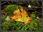 Multi Colored Leaf |
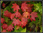 Red On Green |
 Shiny Wet Leaves |
 Snowshed Info |
 Snowshed & Leaves |
 Smooth Easy Trail |
 Trail Along Wall |
 Roof Over Trail |
 Scenic Trailhead |
 Shortcut Trail |
 Toilet With A View |
 Group At Windy Point |
 What A View! |
 New Tunnel Portal |
 Group At A Tunnel |
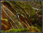
 Kim & Mossy Wall |
 Color & Tunnel |
 Wooden Reservoir |
 Reservoir Info |
 Upper Grade Leaves |
 More Leafy Color |
 Collapsed Snowshed |
Trips - 2012
Home