2-24-12
Gary
wanted to get out for a ski trip. John and I joined him for a combo
trip. A combo is a trip where we ski and also bring snowshoes for
steeper ascents. Just skinny touring skis and not beefier backcountry
skis. Gary has done the loop without the side trip to Table Mountain
many times. I joined him in 2002 when we first went up Table Mountain.
In 2004
we returned but snow conditions stopped us at the flats below
the final climb. Though there had been over a foot of new snow this
week at Snoqualmie Pass we hoped heading farther east would allow for
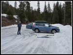
less snow and lower avalanche danger. We met in Bellevue at 7:00 am and
headed east. We turned north on Highway 970 from Cle Elum then 97 to
just before Blewett Pass. The Pipe Creek Sno-Park is non motorized.
There were no other cars when we arrived.
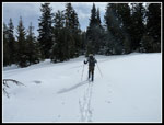
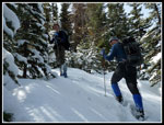
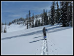
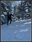
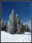
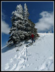
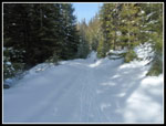
It was just before 9:00 am when we headed out to do the loop counter clockwise. Three to four inches of new snow covered a very hard base layer. No new tracks on the fresh snow. Much better conditions than I had feared. The old road drops a little then begins a steady climb. The start is at about 3600'. The low point after the first short descent is at about 3550'. The road had a bit of crust in many places and some soft fresh snow too. A few icy spots provided little traction. Overall, we did just fine on the skinny skis. John has only been on skis a few times so this would be a little more challenging for him.
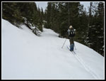
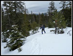
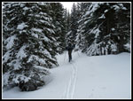
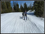
After 1.5 miles there is a signed junction, the second one. Left is an easy loop trail. We headed right. Gary's route more or less follows a rounded ridge. We made many kick turns as we ascended the slope. Trees in this forest are widely spaced making it easy to pick a route up. We reached a road. Left is a short cut back to the main road we would be descending later. We went right and soon left the road heading higher. Cross country skiing on unmarked snow in the forest is much more interesting than groomed tracks. It is very hard to escape grooming on I-90 now so the longer drive was needed to find great unmarked terrain. At least for us non wide skis backcountry skiers.
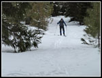
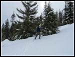
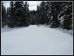
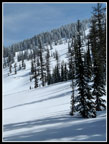
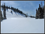
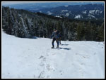
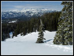
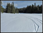
The next landmark was the main road. It is heavily used by snowmobiles. The surface was a bit icy. We only skied this road a short distance. Where the road turns sharply right we went straight ahead. This is signed for non motorized use. A little climbing then one of the highlights of the trip. A series of meadows strung together. The day was forecast to be mostly sunny but so far it had been all gray. As we skied through the meadows some sun began to shine through. Thus far we had gained only about 1300'. The steeper parts were not far away. After the last meadow we had to climb up through some denser forest. This brought us back to the main road right at our next junction.
The uphill turn is the road to Haney Meadow and Table Mountain. I have driven it a number of times. It looks a whole lot different when everything is buried under snow. It had been eight years since our last trip up to Table Mountain and our memories were a little off. We skied up the road passing a spur almost immediately. This seemed too soon so we headed higher on the main wide road. A quarter mile later it was plain that the first road was the correct one. Down we went. There were no recent tracks on the spur road. We skied up the narrow road debating where to turn off. It was an old clear cut with small trees eight years ago. They have grown a lot since then. It looked much different.
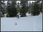
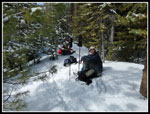
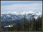
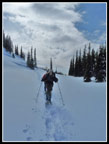
Within less than 10 minutes we turned off left, found a small clearing and took off our skis. It was now 11:50 am so we had some lunch. Snowshoes went on and skis were left behind. Time for part two of the trip. The trees are packed pretty densely through this forest. Our memories were not all that clear. We took the path of least resistance as we wound our way through the trees. The route went a little left then straight uphill then more rightward. The route always provided a way through. The snow was soft enough to have us sinking down 4-8 inches with each step. Breaking trail was tiring and we switched the lead often. An occasional view opened behind us towards Mt. Stuart and peaks of the Teanaway area. All the trees were flocked by the recent snowfall making for beautiful scenery.
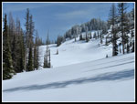
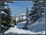
The going became steeper with trees spaced closer together. A little weaving through brought us to gentler terrain. We knew we were close to the flats below the final steep climb to Table Mountain. Soon we popped out of the trees to meadows of untracked snow. There was more sun now and dark tree shadows were set upon the blindingly white snow. This is one really neat place. On our first trip we headed straight up the big open slope in the center. With all the fresh snow and the sun on the slope this did not seem like a prudent choice. Too high a chance of avalanching. Instead we headed to our right towards a more forested slope. The slope was steep but looked like it might work.
As we began to climb we found that there was a very icy crust covered with 4-10 inches of fresh snow. The lesser amount was under tree cover. Steps had a tendency to slide on the hard layer underneath. The crampons did not grip well on the soft powdery snow. Our route went in and out of forest but was pretty safe. With about 150' to go I was leading on a very steep short section where the snow was hip deep. I had to kick three or four times to knock off enough snow to be able to raise my leg up for another step. Very tiring work. Above that things improved. We popped out of the forest and were able to see an open slope to the top. A few minutes later we were on flat ground at the top.
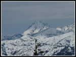
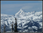
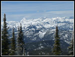
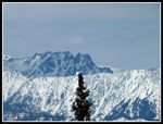
Not surprisingly there were dozens of snowmobile tracks. At 25 mph you can get up there on a snowmobile in about 20 minutes. The view from Table Mountain was spectacular. Diamond Head was just to the north. The Stuart Range and all surrounding peaks were just to the west. Mt. Rainier was completely lost in the clouds and haze to the southwest. We had heard some wind in the trees on the way up but it was very gentle on top. This was only the second ski trip of the year for John and I and Gary had not done any strenuous ones either. The combination of seldom used skiing muscles and breaking trail in deep snow on snowshoes had us all beat. Only about 2500' of gain and it felt like 4000'.
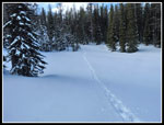
We finished our lunches while admiring the views. One of the best parts was all the rime ice on the trees. Rime on one side, green needles on the other, and bright blue sky overhead. Fantastic. All too soon it was time to head down. We expected the descent to be much faster and we were not disappointed. We were slow and careful on a few steep spots but for the most part it was a fast descent. Back at the flat area below the final climb we noticed all the white clouds moving in. Much different lighting than on our way up. We wound our way back through the forest and soon reached our skis.
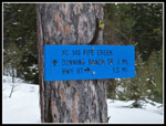
We strapped the skis to our packs and snowshoed down the narrow spur road. Back at the main road the snowshoes were replaced by skis for the trip back to the car. Just a few minutes after exiting the spur road several snowmobiles came down the road and headed up the spur. Great timing to have not had to get around them on the spur. Now thoroughly worn out we still had 1400' to drop. Fortunately, the road is gently graded. A quick drop to the junction, a right turn, and we were on our way. The sign near the junction showed it is four miles down to Blewett Pass. We had about three miles to ski before leaving the road at Swauk Meadow.
The road had been recently groomed and though it had many snowmobile tracks there were no moguls. John did just fine on the descent. It seemed to take forever but we finally reached Swauk Meadow. My two previous trips down the sloping meadow were filled with falls. Fast snow and many snowmobile tracks on one trip though the meadow is a non motorized area. I side stepped down the steep slope to the meadow first and found, much to my surprise, not a single track on this snow since the last snowfall. Acres of uninterrupted white. The snow was slow enough here that I managed to make it all the way down without falling. That was a first.
After the meadow the route is on an old road back to the sno-park. That road had been fast on my two previous trips. This time it was slow enough that my very tired legs could handle it. The "short road" I recalled ended up being more than 1.5 miles. Sometime around 4:30 pm we finished our trip. Once again, not a single car in the lot. We saw a number of snowmobilers, mostly on the road down, but not a single skier or snowshoer all day long. For most of the day we saw no people and no tracks. I had forgotten what a fun trip this is. Skiing up through forest and meadows, snowshoeing to a high viewpoint at 6000', and a fast trip downhill on skis. Gary's GPS recorded 10.7 miles and I estimate 2600' of gain. Almost no ups and downs. We left the west side of the mountains on the first 60 degree day of the year but found near perfect conditions on the east side. A great trip.
Click on thumbnails to get
larger pictures.
Trips - 2012
Home
It was just before 9:00 am when we headed out to do the loop counter clockwise. Three to four inches of new snow covered a very hard base layer. No new tracks on the fresh snow. Much better conditions than I had feared. The old road drops a little then begins a steady climb. The start is at about 3600'. The low point after the first short descent is at about 3550'. The road had a bit of crust in many places and some soft fresh snow too. A few icy spots provided little traction. Overall, we did just fine on the skinny skis. John has only been on skis a few times so this would be a little more challenging for him.
After 1.5 miles there is a signed junction, the second one. Left is an easy loop trail. We headed right. Gary's route more or less follows a rounded ridge. We made many kick turns as we ascended the slope. Trees in this forest are widely spaced making it easy to pick a route up. We reached a road. Left is a short cut back to the main road we would be descending later. We went right and soon left the road heading higher. Cross country skiing on unmarked snow in the forest is much more interesting than groomed tracks. It is very hard to escape grooming on I-90 now so the longer drive was needed to find great unmarked terrain. At least for us non wide skis backcountry skiers.
The next landmark was the main road. It is heavily used by snowmobiles. The surface was a bit icy. We only skied this road a short distance. Where the road turns sharply right we went straight ahead. This is signed for non motorized use. A little climbing then one of the highlights of the trip. A series of meadows strung together. The day was forecast to be mostly sunny but so far it had been all gray. As we skied through the meadows some sun began to shine through. Thus far we had gained only about 1300'. The steeper parts were not far away. After the last meadow we had to climb up through some denser forest. This brought us back to the main road right at our next junction.
The uphill turn is the road to Haney Meadow and Table Mountain. I have driven it a number of times. It looks a whole lot different when everything is buried under snow. It had been eight years since our last trip up to Table Mountain and our memories were a little off. We skied up the road passing a spur almost immediately. This seemed too soon so we headed higher on the main wide road. A quarter mile later it was plain that the first road was the correct one. Down we went. There were no recent tracks on the spur road. We skied up the narrow road debating where to turn off. It was an old clear cut with small trees eight years ago. They have grown a lot since then. It looked much different.
Within less than 10 minutes we turned off left, found a small clearing and took off our skis. It was now 11:50 am so we had some lunch. Snowshoes went on and skis were left behind. Time for part two of the trip. The trees are packed pretty densely through this forest. Our memories were not all that clear. We took the path of least resistance as we wound our way through the trees. The route went a little left then straight uphill then more rightward. The route always provided a way through. The snow was soft enough to have us sinking down 4-8 inches with each step. Breaking trail was tiring and we switched the lead often. An occasional view opened behind us towards Mt. Stuart and peaks of the Teanaway area. All the trees were flocked by the recent snowfall making for beautiful scenery.
The going became steeper with trees spaced closer together. A little weaving through brought us to gentler terrain. We knew we were close to the flats below the final steep climb to Table Mountain. Soon we popped out of the trees to meadows of untracked snow. There was more sun now and dark tree shadows were set upon the blindingly white snow. This is one really neat place. On our first trip we headed straight up the big open slope in the center. With all the fresh snow and the sun on the slope this did not seem like a prudent choice. Too high a chance of avalanching. Instead we headed to our right towards a more forested slope. The slope was steep but looked like it might work.
As we began to climb we found that there was a very icy crust covered with 4-10 inches of fresh snow. The lesser amount was under tree cover. Steps had a tendency to slide on the hard layer underneath. The crampons did not grip well on the soft powdery snow. Our route went in and out of forest but was pretty safe. With about 150' to go I was leading on a very steep short section where the snow was hip deep. I had to kick three or four times to knock off enough snow to be able to raise my leg up for another step. Very tiring work. Above that things improved. We popped out of the forest and were able to see an open slope to the top. A few minutes later we were on flat ground at the top.
Not surprisingly there were dozens of snowmobile tracks. At 25 mph you can get up there on a snowmobile in about 20 minutes. The view from Table Mountain was spectacular. Diamond Head was just to the north. The Stuart Range and all surrounding peaks were just to the west. Mt. Rainier was completely lost in the clouds and haze to the southwest. We had heard some wind in the trees on the way up but it was very gentle on top. This was only the second ski trip of the year for John and I and Gary had not done any strenuous ones either. The combination of seldom used skiing muscles and breaking trail in deep snow on snowshoes had us all beat. Only about 2500' of gain and it felt like 4000'.
We finished our lunches while admiring the views. One of the best parts was all the rime ice on the trees. Rime on one side, green needles on the other, and bright blue sky overhead. Fantastic. All too soon it was time to head down. We expected the descent to be much faster and we were not disappointed. We were slow and careful on a few steep spots but for the most part it was a fast descent. Back at the flat area below the final climb we noticed all the white clouds moving in. Much different lighting than on our way up. We wound our way back through the forest and soon reached our skis.
We strapped the skis to our packs and snowshoed down the narrow spur road. Back at the main road the snowshoes were replaced by skis for the trip back to the car. Just a few minutes after exiting the spur road several snowmobiles came down the road and headed up the spur. Great timing to have not had to get around them on the spur. Now thoroughly worn out we still had 1400' to drop. Fortunately, the road is gently graded. A quick drop to the junction, a right turn, and we were on our way. The sign near the junction showed it is four miles down to Blewett Pass. We had about three miles to ski before leaving the road at Swauk Meadow.
The road had been recently groomed and though it had many snowmobile tracks there were no moguls. John did just fine on the descent. It seemed to take forever but we finally reached Swauk Meadow. My two previous trips down the sloping meadow were filled with falls. Fast snow and many snowmobile tracks on one trip though the meadow is a non motorized area. I side stepped down the steep slope to the meadow first and found, much to my surprise, not a single track on this snow since the last snowfall. Acres of uninterrupted white. The snow was slow enough here that I managed to make it all the way down without falling. That was a first.
After the meadow the route is on an old road back to the sno-park. That road had been fast on my two previous trips. This time it was slow enough that my very tired legs could handle it. The "short road" I recalled ended up being more than 1.5 miles. Sometime around 4:30 pm we finished our trip. Once again, not a single car in the lot. We saw a number of snowmobilers, mostly on the road down, but not a single skier or snowshoer all day long. For most of the day we saw no people and no tracks. I had forgotten what a fun trip this is. Skiing up through forest and meadows, snowshoeing to a high viewpoint at 6000', and a fast trip downhill on skis. Gary's GPS recorded 10.7 miles and I estimate 2600' of gain. Almost no ups and downs. We left the west side of the mountains on the first 60 degree day of the year but found near perfect conditions on the east side. A great trip.
 Pipe Creek Sno-Park |
 Untracked Snow |
 John Skiing Road |
 Trail Sign |
 Off Road Skiing |
 Gary Kick Turning |
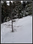 Larch Tree |
 John Is Right Behind |
 Gary Crossing Meadow |
 Untracked Meadow |
 Narrowing Route |
 Lunch Time |
 Ascending On Snowshoes |
 Flats Below Table Mt. |
 Blue Sky & Bright Snow |
 Ascending Meadow |
 Heading For Far Ridge |
 Mt. Stuart In Sight |
 Peaks To The West |
 Diamond Head |
 Steep Climb |
 Near The Top |
 Rime Ice |
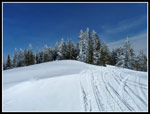 Table Mt. Summit |
 Icy Trees |
 Mt. Stuart From Top |
 North Of Stuart Range |
 Stuart Range Area |
 John Heading Down |
 Following Our Tracks |
 Back To The Flats |
 Lone Track |
 Descending Spur Road |
 Back On Skis |
 Swauk Meadow |
Trips - 2012
Home