12-31-12
Almost
every New Years Eve I do a hike on Tiger Mountain. This tradition began
in 1983,
my second year of regular hiking. Since then I have only missed one New
Years Eve hike. After two hikes the previous three days I was a bit
tired. Gary came up with a challenging trip from the far south to the
north side of Tiger. It visited three summits. With snow at higher
elevations it would be tough to get in the full route in daylight. I
signed on. I met Gary and John at High Point on the north side. We
drove around to the south side. This would be a one way trip. Just a
few minutes into the trip we passed a lone hiker. That was it for the
next 8.5 hours. It had been ten years since Gary and I had been to the
Grand Canyon of Fifteen Mile Creek. We each had an idea of the route on
the unofficial boot path that goes up to the Hobart Railroad Grade. It
was not how we remembered it. Our journey was off to an interesting
beginning.
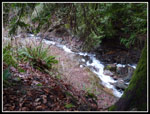
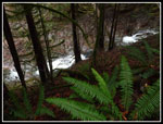
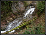
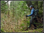
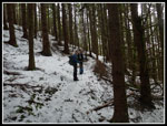
The trail is in fine shape up the Grand Canyon. The canyon narrows greatly as we proceeded. Soon the tread was much worses than we recalled. A trail headed off uphill but it was not the one we had done before. We continued to where the narrow tread dropped to the creek. Into the creek. This was very different than ten years earlier. Our GPS maps showed the route going up the creek for a ways farther before heading uphill. We were not anxious to go knee deep wading up the creek at the start of a long hike. We backtracked. It is very steep to get out of the canyon. Several possibilities did not look promising. We ended back at the first trail we had seen. It quickly turns straight uphill. The lip of the canyon proved to be a real scramble but we made it up onto the ridge.
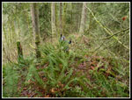
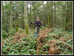
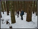
No signs of a trail, or a boot path. Some brush, forest, and downed logs. The map showed that following the ridge up would bring us to the Hobart grade. Up we went. By this time we had spent nearly an hour and not gone far. The ridge was slow and tiring but not too bad. There are ribbons up there but no tread. We finally hit a trail. It was the old trail Gary and I have done several times before coming up from the creek. Our junction was just a few yards before the railroad grade. It was 9:50 when we reached the grade. It took us 1.5 hours to hike 2.3 miles. The route finding and off trail bushwhacking put us well behind schedule. We still had a long way to go. On the positive side, we were back on trail.
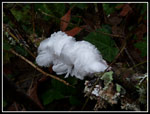
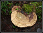
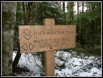
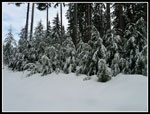
Near the start we saw a strange bright white fungus of some type. It had many thin tendrils. Along the Hobart grade we saw much more of it. If I've seen it before I do not recall. The grade was much faster. A little muddy in places but no downed logs to crawl over. Now at 1575' we saw patches of snow. We were still more than 1400' below our intended high point. We allowed for the possibility of missing East Tiger Mountain if the snow was too soft and we ended up with a lot of deep post holing on the road sections where the snow would be deepest. Although our next destination Middle Tiger Mountain was right above us, the route took us far to the north then back to the south. Along the grade we noticed one old cable spanning a ravine. John showed us his high wire act, such as it was. From the Hobart grade we had .25 miles uphill to reach the Tiger Mountain Trail (TMT). At the TMT we turned to the right.
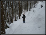
The TMT is a fine trail but not as flat as the railroad grade. Lots of ups and downs. From the Hobart Grade on we saw footprints in most of the snow patches. I was surprised to see them in these lesser visited parts of Tiger. Especially in the winter. At the Middle Tiger junction we took a short break. Although we were at about 2150' it was a few degrees above freezing. Warmer than we had planned for. The half mile trail up Middle Tiger was mostly bare at the bottom but soon was fully snow covered. Not enough footprints to polish it to an icy surface. We had fine traction. We reached the Middle Tiger summit at 11:30 am. Just about five miles into our day. five hours of daylight left but still a long way to go.
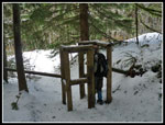
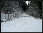
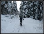
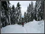
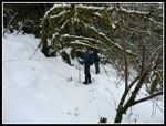
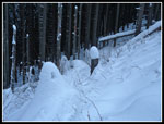
We descended from Middle Tiger to the logging spur below. We knew that once out of the forest the snow would be deeper. Just how soft it would be would determine whether we could reach East Tiger or detour directly to West Tiger 1. At the bottom of the trail is a wooden gate to keep out bikes and horses. It is the narrowest one I have ever seen. I had to know if beanpole Gary could fit through. Much to my surprise he did though even he had to turn a little to fit. As expected the snow was now several feet deep. There were some post holes from a hiker who had passed through when the snow was much softer. For the most part it held our weight. John and I had more problems with sinking knee deep or more. It was tiring but not as bad as I feared. After the unexpected bushwhacking I did not need more extra tiring travel. If the main road was even softer that would probably rule out East Tiger for me.
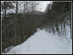
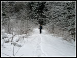
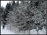
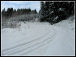
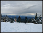
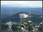
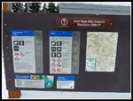
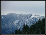
Soon enough we reached the road coming from Tiger Summit on Highway 18. There were tracks on it. Nicely compacted and firm tracks. This was a game changer. No more post holing. Much easier travel. Up we headed towards East Tiger Mountain. One can follow the road all the way around East Tiger and up to the summit. This is much longer than we had time for. Instead we left the road in the vicinity of the Preston Railroad Grade. We slogged up the steep slope directly towards the summit. The snow was much softer in the forest. Much deeper too. This was slow going but not a great distance. We were all pleased to reach the road just below the 3004' summit. In a short time we were on top. One great thing about the day was a total lack of wind. it was cold but not as bad as it might have been. Since my last visit the DNR folks have put up an information board with a full map of Tiger and all the trails.
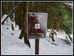
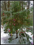
We had some of our lunch on Middle Tiger and more of it on East Tiger. It was 12:54 and we were 7 miles into our trip. We still had half the distance to cover and only 3.5 hours. It had take a little over 4.5 hours so far. On the positive side, we had gained 2700'. There was much less to gain the rest of the way. Now came the most important bit of navigating. The East Tiger Trail over to the Christmas Tree near Tiger 1 is a sketchy trail in the summer. It would be completely under snow this day. We used our GPS units extensively to find our way. It worked well as we reached the Preston Railroad Grade right at the junction with the East Tiger Trail. The snow was less deep now and we could see cut logs and figure the trail location much better. There are also a number of paint spots on trees to help with navigation. We continued to drop to the 2180' low point. A little climbing brought us to the junction with the Paw Print Trail. A few minutes later we were at the Christmas Tree. Just 12 days earlier we did a headlamp hike there in non stop rain. Much nicer this day. We picked up a filled balloon a few minutes earlier and added it to the Christmas Tree.
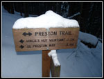
It was now 2:48 pm. Just under two hours of daylight left. We could take the Bootleg Trail directly down as we did on the headlamp hike. We could continue another 1.2 miles uphill to the summit of 2948' West Tiger 1. I was beat . We chose to head up. We saw no footprints on the East Tiger Trail but we had them on the Bootleg. No need for GPS navigation. Climbing another 650' on snow was a pain. It was slow. Up we went. At the junction with the Preston Trail is became flatter. Just three days earlier I came up the Preston Trail and had to kick a trail in deep snow the last short way to the summit. This day there was a packed track. I turned around almost immediately and headed down. The others had another short food break. We met up again at the Preston Trail junction. this route was much more packed down than on Friday. It was a bit slick too. Might have stopped to but on traction devices but we chose to slide on down. I was surprise that nobody took a tumble.
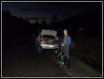
We made very good time downhill. The snow was getting thin at Fred's Corner and disappeared once off the old High Point Trail. Back on the smooth TMT in forest without snow we sped up more. The battle was on to see if we could make it out before darkness forced us to take out our headlamps. We just made it. On Saturday I finished hiking at Wallace Lake at 5:05. This day we reached the car at 5:08. Dark but not quite pitch black. I drove back to the south side of the mountain to Gary's car.
This was probably the most ambitious and likely the most fun New Years Eve Tiger hike so far. It was definitely the most tiring. Per John's and my GPS units it looks like we hiked about 14 miles with 3800' of gain. Since we started higher than we finished we had over 4000' of descent. Lots of snow, a little unplanned bushwhacking, some careful navigation, good friends, led to a heck of a great New Years hike!
Click on thumbnails to get
larger pictures.
Trips - 2012
Home
The trail is in fine shape up the Grand Canyon. The canyon narrows greatly as we proceeded. Soon the tread was much worses than we recalled. A trail headed off uphill but it was not the one we had done before. We continued to where the narrow tread dropped to the creek. Into the creek. This was very different than ten years earlier. Our GPS maps showed the route going up the creek for a ways farther before heading uphill. We were not anxious to go knee deep wading up the creek at the start of a long hike. We backtracked. It is very steep to get out of the canyon. Several possibilities did not look promising. We ended back at the first trail we had seen. It quickly turns straight uphill. The lip of the canyon proved to be a real scramble but we made it up onto the ridge.
No signs of a trail, or a boot path. Some brush, forest, and downed logs. The map showed that following the ridge up would bring us to the Hobart grade. Up we went. By this time we had spent nearly an hour and not gone far. The ridge was slow and tiring but not too bad. There are ribbons up there but no tread. We finally hit a trail. It was the old trail Gary and I have done several times before coming up from the creek. Our junction was just a few yards before the railroad grade. It was 9:50 when we reached the grade. It took us 1.5 hours to hike 2.3 miles. The route finding and off trail bushwhacking put us well behind schedule. We still had a long way to go. On the positive side, we were back on trail.
Near the start we saw a strange bright white fungus of some type. It had many thin tendrils. Along the Hobart grade we saw much more of it. If I've seen it before I do not recall. The grade was much faster. A little muddy in places but no downed logs to crawl over. Now at 1575' we saw patches of snow. We were still more than 1400' below our intended high point. We allowed for the possibility of missing East Tiger Mountain if the snow was too soft and we ended up with a lot of deep post holing on the road sections where the snow would be deepest. Although our next destination Middle Tiger Mountain was right above us, the route took us far to the north then back to the south. Along the grade we noticed one old cable spanning a ravine. John showed us his high wire act, such as it was. From the Hobart grade we had .25 miles uphill to reach the Tiger Mountain Trail (TMT). At the TMT we turned to the right.
The TMT is a fine trail but not as flat as the railroad grade. Lots of ups and downs. From the Hobart Grade on we saw footprints in most of the snow patches. I was surprised to see them in these lesser visited parts of Tiger. Especially in the winter. At the Middle Tiger junction we took a short break. Although we were at about 2150' it was a few degrees above freezing. Warmer than we had planned for. The half mile trail up Middle Tiger was mostly bare at the bottom but soon was fully snow covered. Not enough footprints to polish it to an icy surface. We had fine traction. We reached the Middle Tiger summit at 11:30 am. Just about five miles into our day. five hours of daylight left but still a long way to go.
We descended from Middle Tiger to the logging spur below. We knew that once out of the forest the snow would be deeper. Just how soft it would be would determine whether we could reach East Tiger or detour directly to West Tiger 1. At the bottom of the trail is a wooden gate to keep out bikes and horses. It is the narrowest one I have ever seen. I had to know if beanpole Gary could fit through. Much to my surprise he did though even he had to turn a little to fit. As expected the snow was now several feet deep. There were some post holes from a hiker who had passed through when the snow was much softer. For the most part it held our weight. John and I had more problems with sinking knee deep or more. It was tiring but not as bad as I feared. After the unexpected bushwhacking I did not need more extra tiring travel. If the main road was even softer that would probably rule out East Tiger for me.
Soon enough we reached the road coming from Tiger Summit on Highway 18. There were tracks on it. Nicely compacted and firm tracks. This was a game changer. No more post holing. Much easier travel. Up we headed towards East Tiger Mountain. One can follow the road all the way around East Tiger and up to the summit. This is much longer than we had time for. Instead we left the road in the vicinity of the Preston Railroad Grade. We slogged up the steep slope directly towards the summit. The snow was much softer in the forest. Much deeper too. This was slow going but not a great distance. We were all pleased to reach the road just below the 3004' summit. In a short time we were on top. One great thing about the day was a total lack of wind. it was cold but not as bad as it might have been. Since my last visit the DNR folks have put up an information board with a full map of Tiger and all the trails.
We had some of our lunch on Middle Tiger and more of it on East Tiger. It was 12:54 and we were 7 miles into our trip. We still had half the distance to cover and only 3.5 hours. It had take a little over 4.5 hours so far. On the positive side, we had gained 2700'. There was much less to gain the rest of the way. Now came the most important bit of navigating. The East Tiger Trail over to the Christmas Tree near Tiger 1 is a sketchy trail in the summer. It would be completely under snow this day. We used our GPS units extensively to find our way. It worked well as we reached the Preston Railroad Grade right at the junction with the East Tiger Trail. The snow was less deep now and we could see cut logs and figure the trail location much better. There are also a number of paint spots on trees to help with navigation. We continued to drop to the 2180' low point. A little climbing brought us to the junction with the Paw Print Trail. A few minutes later we were at the Christmas Tree. Just 12 days earlier we did a headlamp hike there in non stop rain. Much nicer this day. We picked up a filled balloon a few minutes earlier and added it to the Christmas Tree.
It was now 2:48 pm. Just under two hours of daylight left. We could take the Bootleg Trail directly down as we did on the headlamp hike. We could continue another 1.2 miles uphill to the summit of 2948' West Tiger 1. I was beat . We chose to head up. We saw no footprints on the East Tiger Trail but we had them on the Bootleg. No need for GPS navigation. Climbing another 650' on snow was a pain. It was slow. Up we went. At the junction with the Preston Trail is became flatter. Just three days earlier I came up the Preston Trail and had to kick a trail in deep snow the last short way to the summit. This day there was a packed track. I turned around almost immediately and headed down. The others had another short food break. We met up again at the Preston Trail junction. this route was much more packed down than on Friday. It was a bit slick too. Might have stopped to but on traction devices but we chose to slide on down. I was surprise that nobody took a tumble.
We made very good time downhill. The snow was getting thin at Fred's Corner and disappeared once off the old High Point Trail. Back on the smooth TMT in forest without snow we sped up more. The battle was on to see if we could make it out before darkness forced us to take out our headlamps. We just made it. On Saturday I finished hiking at Wallace Lake at 5:05. This day we reached the car at 5:08. Dark but not quite pitch black. I drove back to the south side of the mountain to Gary's car.
This was probably the most ambitious and likely the most fun New Years Eve Tiger hike so far. It was definitely the most tiring. Per John's and my GPS units it looks like we hiked about 14 miles with 3800' of gain. Since we started higher than we finished we had over 4000' of descent. Lots of snow, a little unplanned bushwhacking, some careful navigation, good friends, led to a heck of a great New Years hike!
 Bright White Fungus |
 Fifteen Mile Creek |
 Ooze From Mine Shaft |
 The Grand Canyon |
 Cascades |
 Bushwhacking |
 Gary Off Trail |
 Big Fungus |
 Tightrope Walker |
 Clapp's Crossing |
 Sign On TMT |
 Middle Tiger Junction |
 Snow On Trail |
 Gate Below Middle Tiger |
 Deeper Snow On Road |
 Hiking Spur Road |
 Icy White Trees |
 Snow Up To Gate |
 Main Road Packed Down |
 Plastered Trees |
 Heading Up East Tiger |
 Nearing The Summit |
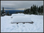 Snow Covered Tables |
 Gary & John On Summit |
 South Tiger Mt. |
 New Info Board |
 Heading Down |
 East Tiger Trail |
 Snow Covered Trail |
 Mts. Si & Teneriffe |
 Mossy Trees |
 Mossier Trees |
 Christmas Tree |
 Below Tiger 1 |
 Preston Trail |
 Back At Darkness |
Trips - 2012
Home