5-12-12
Gary,
John, and I planned a snow
scramble of Navaho Peak. Unfortunately, the Stafford Road was closed 2
1/2 miles before the trailhead and avalanche danger was extremely high
for the weekend. A last minute change was needed. We chose a snow free
hike with lots of mileage. Gary and I had done the loop around Wallace
Falls and Lake but John had not. I have been to Jay Lake several times.
We decided to add that second lake. Since this would be a near 80
degree day the crowds were assured. We chose an early start. We arrived
at Wallace Falls State Park around 8:00 am to find a number of cars
already there. A few minutes later we were on our way.
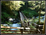
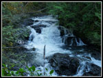
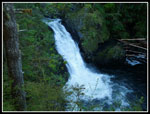
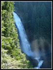
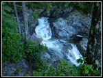
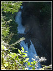
I chose to do a figure eight loop. We headed up the old railroad grade. It was sunny and warming fast. Long sleeves and long pants legs did not last long. Just before the Greg Ball Trail we headed down to meet the Woody Trail. We crossed the North Fork of the Wallace River then it was all uphill. A stop at the shelter for photos of the lower falls then back on our way. The sun was awful for photos of the falls but our early visit meant there were no crowds. We saw just a few people. From the middle falls viewpoint we could see a rainbow in the spray below us. After a short break for more photos at the upper falls viewpoint we headed up to the old road above us.
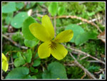
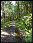
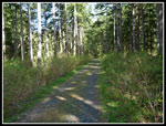
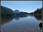
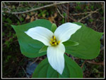
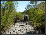
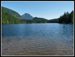
The first half of the route from the viewpoint is barely a boot path. It amazes me that the upper part is built trail while the lower part is hard to find. With 90% of the elevation gain to Wallace Lake out of the way the next 2.3 miles to the lake is an easy walk. When the logging road in the middle was built it was a stark cut. Now brush and trees are growing along the side and it looks much better. At a few boggy spots we found skunk cabbage in bloom. There are still trillium, yellow violets, and bleeding hearts blooming around the loop too. We continued past the Wallace Lake outlet and headed to the other end of the lake. I often hike here in the winter and am slogging in snow around the lake more often than not. It is long gone now.
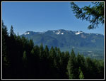
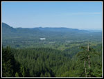
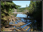
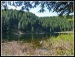
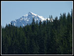
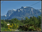
I expected the inlet creek would be raging but much to my surprise it was dry. We had an easy time walking the creek bed to Pebble Beach. The lake level is high and there are no pebbles showing at this time. We did enjoy a long early lunch here with views down the lake and to a snow covered peak in the distance. A check of the map suggested it was Mt. Index. I pulled out my GPS to find that the map was gone. In fact the screen was frozen. I could turn it off and tried to restart it. That did not work. I took out the batteries and waited. Still not working when I turned it back on. I was afraid it was toast when John suggested taking out the memory card. That did the trick. It was working again. Unfortunately, we now did not have the map. This proved to be a problem a little later.
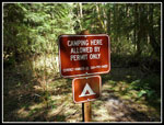
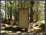
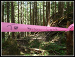
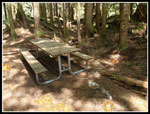
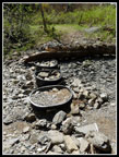
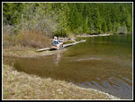
Not ready to turn back after "only" 6 3/4 miles we headed on to Jay Lake. Crossing the inlet creek can be wet in high water but the parks people have placed big round plastic pots filled with rocks across the creek bed. Not needed this day there are times in the spring they will prove useful. On my first visit to Jay Lake in 1994 we headed up the creek bed and beat brush on the left side of the creek. On my second visit in 2002 I found the old road that makes the walk very easy. The sign says 1 mile to Jay Lake. My GPS says .80 miles. Jay Lake now has a new outhouse, four tent sites, a picnic table chained to a tree, and a bucket on a rope to hang food. A big sign says "Camping Here Allowed By Permit Only". Check with the state park if you want to camp.
Any sensible people would have turned around here. We are not sensible people. We pulled out the paper map and checked the distance to Shaw Lake. I have been aware of Shaw Lake since my first visit to Jay. I was not sure if there was any trail or just how far the old road we took from Wallace Lake would go. Turning around here would give us a 14 mile day. We chose to take a stab at Shaw. It is a little more than a mile from Jay as the crow flies. Trails are rarely that straight.
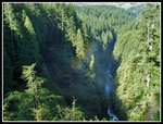
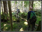
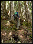
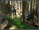
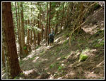
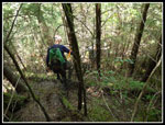
The good news was that while the old road quickly became filled with salmonberries and assorted sticky brush there was a path carved through it. In short order we reached the creek between Jay and Shaw Lakes. Not too hard to get across with dry feet. On the other side the terrain headed for the sky. Straight up a very steep hillside. We found bits of plastic tape headed up. Off we went. While there is precious little trail or boot path on the climb there is enough tape to keep you heading in the right direction. This is absolutely not a "trail". It is a scrambly route. After about 350' of steep climbing we reached a ridge top. From here the route is a series of paths, road sections, and bushwhacking. Trees have fallen across what might have been easy walking at an earlier time. Again, there is enough plastic tape to never be totally out of sight of the next objective.
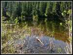
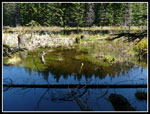
We descended a ways to find a lake! Shaw Lake? An old road went around the left side of the lake. We were surprised to find the outlet on this side dropping down to Highway 2 not at the end dropping to Jay Lake. A red flag. With a map on my GPS it would have been easy to pinpoint us and Shaw Lake. We could have taken coordinates from the GPS and plotted them on the paper map. Instead we guessed our route from the terrain and figured that we were at Shaw Lake. We were wrong. When I returned home and downloaded the GPS track it was clear we were at a smaller lake that was not on the paper map. Live and learn. If the road continued in good shape we were about 10 minutes from Shaw lake. Less than half a flat mile.
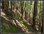
Our trip back to Jay Lake was much easier as we now knew where the route was. The route was well designed as it follows a narrow ridge top at one point with near vertical drops on both sides. It also crosses a steep slope where the very narrow tread is just enough to safely cross. Back at Jay Lake John and I compared scrapes and cuts. Gary did the bushwhacking route in long pants. An easy .80 miles brought us back to Wallace Lake. We took another long break at Pebble Beach. The sun had moved quite a ways since our earlier stop and there was far less glare. Much better photos. We saw a couple folks rafting on the lake. Not a bad way to spend the warmest day of the year so far.
So much of this route is in forest that we never did put on sunscreen. It made for a fairly cool hike. We headed back around Wallace Lake and down to the newer logging road. A short way down that is the Greg Ball Trail. That made for a nice gentle route back down. I was surprised to see several groups at Wallace Lake and coming up to the lake in the later afternoon. Nothing like the mob at the falls but more than I used to see. Back at the railroad grade we took the connector for the second time this day down to the Woody Trail. This time we turned right and followed the Woody Trail on down. As expected there were many people on this trail going up and down. It slowed us down a bit but soon we were back at the trailhead. It was just before 5:00 pm.
The GPS showed we hiked 16.9 miles with 2900' of gain. Almost 1000' came after we reached Wallace Lake. The day proved to be much more interesting than I expected. We did not set out to reach Shaw Lake and we did not do it but came very close. Now we will have to go back for the final third of a mile. It was a very pleasant spring day in a very crowded place where we avoided most of the people until the last mile and a half. A really fun hike. As expected the parking lot was nearly full. I'm sure it was full an hour earlier. Driving out we counted cars parked along the road. An even 50. Added to the parking lot there were at least 100 cars there. Amazing but understandable on a beautiful spring day.
I chose to do a figure eight loop. We headed up the old railroad grade. It was sunny and warming fast. Long sleeves and long pants legs did not last long. Just before the Greg Ball Trail we headed down to meet the Woody Trail. We crossed the North Fork of the Wallace River then it was all uphill. A stop at the shelter for photos of the lower falls then back on our way. The sun was awful for photos of the falls but our early visit meant there were no crowds. We saw just a few people. From the middle falls viewpoint we could see a rainbow in the spray below us. After a short break for more photos at the upper falls viewpoint we headed up to the old road above us.
The first half of the route from the viewpoint is barely a boot path. It amazes me that the upper part is built trail while the lower part is hard to find. With 90% of the elevation gain to Wallace Lake out of the way the next 2.3 miles to the lake is an easy walk. When the logging road in the middle was built it was a stark cut. Now brush and trees are growing along the side and it looks much better. At a few boggy spots we found skunk cabbage in bloom. There are still trillium, yellow violets, and bleeding hearts blooming around the loop too. We continued past the Wallace Lake outlet and headed to the other end of the lake. I often hike here in the winter and am slogging in snow around the lake more often than not. It is long gone now.
I expected the inlet creek would be raging but much to my surprise it was dry. We had an easy time walking the creek bed to Pebble Beach. The lake level is high and there are no pebbles showing at this time. We did enjoy a long early lunch here with views down the lake and to a snow covered peak in the distance. A check of the map suggested it was Mt. Index. I pulled out my GPS to find that the map was gone. In fact the screen was frozen. I could turn it off and tried to restart it. That did not work. I took out the batteries and waited. Still not working when I turned it back on. I was afraid it was toast when John suggested taking out the memory card. That did the trick. It was working again. Unfortunately, we now did not have the map. This proved to be a problem a little later.
Not ready to turn back after "only" 6 3/4 miles we headed on to Jay Lake. Crossing the inlet creek can be wet in high water but the parks people have placed big round plastic pots filled with rocks across the creek bed. Not needed this day there are times in the spring they will prove useful. On my first visit to Jay Lake in 1994 we headed up the creek bed and beat brush on the left side of the creek. On my second visit in 2002 I found the old road that makes the walk very easy. The sign says 1 mile to Jay Lake. My GPS says .80 miles. Jay Lake now has a new outhouse, four tent sites, a picnic table chained to a tree, and a bucket on a rope to hang food. A big sign says "Camping Here Allowed By Permit Only". Check with the state park if you want to camp.
Any sensible people would have turned around here. We are not sensible people. We pulled out the paper map and checked the distance to Shaw Lake. I have been aware of Shaw Lake since my first visit to Jay. I was not sure if there was any trail or just how far the old road we took from Wallace Lake would go. Turning around here would give us a 14 mile day. We chose to take a stab at Shaw. It is a little more than a mile from Jay as the crow flies. Trails are rarely that straight.
The good news was that while the old road quickly became filled with salmonberries and assorted sticky brush there was a path carved through it. In short order we reached the creek between Jay and Shaw Lakes. Not too hard to get across with dry feet. On the other side the terrain headed for the sky. Straight up a very steep hillside. We found bits of plastic tape headed up. Off we went. While there is precious little trail or boot path on the climb there is enough tape to keep you heading in the right direction. This is absolutely not a "trail". It is a scrambly route. After about 350' of steep climbing we reached a ridge top. From here the route is a series of paths, road sections, and bushwhacking. Trees have fallen across what might have been easy walking at an earlier time. Again, there is enough plastic tape to never be totally out of sight of the next objective.
We descended a ways to find a lake! Shaw Lake? An old road went around the left side of the lake. We were surprised to find the outlet on this side dropping down to Highway 2 not at the end dropping to Jay Lake. A red flag. With a map on my GPS it would have been easy to pinpoint us and Shaw Lake. We could have taken coordinates from the GPS and plotted them on the paper map. Instead we guessed our route from the terrain and figured that we were at Shaw Lake. We were wrong. When I returned home and downloaded the GPS track it was clear we were at a smaller lake that was not on the paper map. Live and learn. If the road continued in good shape we were about 10 minutes from Shaw lake. Less than half a flat mile.
Our trip back to Jay Lake was much easier as we now knew where the route was. The route was well designed as it follows a narrow ridge top at one point with near vertical drops on both sides. It also crosses a steep slope where the very narrow tread is just enough to safely cross. Back at Jay Lake John and I compared scrapes and cuts. Gary did the bushwhacking route in long pants. An easy .80 miles brought us back to Wallace Lake. We took another long break at Pebble Beach. The sun had moved quite a ways since our earlier stop and there was far less glare. Much better photos. We saw a couple folks rafting on the lake. Not a bad way to spend the warmest day of the year so far.
So much of this route is in forest that we never did put on sunscreen. It made for a fairly cool hike. We headed back around Wallace Lake and down to the newer logging road. A short way down that is the Greg Ball Trail. That made for a nice gentle route back down. I was surprised to see several groups at Wallace Lake and coming up to the lake in the later afternoon. Nothing like the mob at the falls but more than I used to see. Back at the railroad grade we took the connector for the second time this day down to the Woody Trail. This time we turned right and followed the Woody Trail on down. As expected there were many people on this trail going up and down. It slowed us down a bit but soon we were back at the trailhead. It was just before 5:00 pm.
The GPS showed we hiked 16.9 miles with 2900' of gain. Almost 1000' came after we reached Wallace Lake. The day proved to be much more interesting than I expected. We did not set out to reach Shaw Lake and we did not do it but came very close. Now we will have to go back for the final third of a mile. It was a very pleasant spring day in a very crowded place where we avoided most of the people until the last mile and a half. A really fun hike. As expected the parking lot was nearly full. I'm sure it was full an hour earlier. Driving out we counted cars parked along the road. An even 50. Added to the parking lot there were at least 100 cars there. Amazing but understandable on a beautiful spring day.
GPS
Map Of Route
Click on thumbnails to get
larger pictures.
Trips - 2012
Home
 Bridge Over NF |
 Cascades |
 Lower Falls |
 Middle Falls |
 Mt. Sultan |
 Small Falls |
 Skykomish Vallley |
 Rainbow |
 Upper Falls |
 Yellow Violet |
 Old Road |
 New Road |
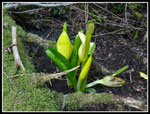 Skunk Cabbage |
 Wallace Lake Outlet |
 Wallace Lake |
 Permit For Jay Lake |
 Jay Lake |
 New Outhouse |
 Leaving Jay Lake |
 Steep Climb |
 Leveling Off |
 "Not Shaw Lake" |
 Heading Back |
 Hillside Traverse |
 Tale Of The Tape |
 Steeply Down |
 Trillium |
 Jay Lake Again |
 Do Not Steal! |
 Creek Crossing Steps |
 Wallace Inlet |
 Mt. Index |
 Wallace Lake Again |
 Gary & John |
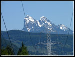
 Mts. Index & Persis |
 Mt. Baring |
Trips - 2012
Home