10-20-13
Nearly
a week of fog in the lowlands. Seattle in a dark mist most all day
long. Cold temperatures. Saturday I rose above it at Blanchard Hill.
Sunday it was time for a little higher summit. Gwen went in on Saturday
and stayed the night. Kim and I headed out of Seattle at 7:10 am. Up to
Granite Falls and down the Mountain Loop Highway. We turned off right
before Red Bridge, took a right a little over a mile up the road. From
there we cruised on the surprisingly smooth gravel road to the
trailhead. There is minimal room to turn around at the end of the road.
We parked a little before the end right behind Gwen's car. There were 7
or 8 parked cars. It was a little chilly at 9:05 am but it was warmer
at 3080' than it had been in Seattle. We left the fog around Robe and
it was all blue sky at the trailhead.
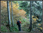
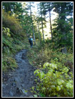
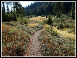
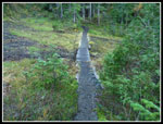
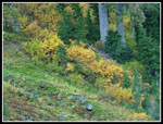
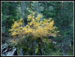
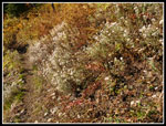
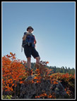
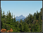
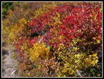
The Walt Bailey Trail up to the Cutthroat Lakes is a volunteer built route. It is rooty and rocky and often muddy. Poles were very helpful in keeping me on my feet. Rather than a climb to the top it is a series of ups and downs, dark forest and open meadows. The numerous big and small meadows are a highlight of this trip. The bright red leaves were missing on this trip but there was a lot of bright yellow and orange. We made consistent progress though I took a whole lot of photos. One faster group passed on by. The route drops down into a valley and crosses to the far side. It was quite cold down there as the sun hardly touches it this time of year. The trail contours along the side of the valley dropping down to 3350' before beginning the climb up to the lakes.
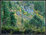
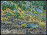
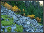
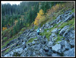
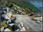
There is a 2 mile marker on a tree near the start of the climb. The trail is rocky with a number of slick old steps. There is one switchback where a tree has fallen across the trail. It is not too hard to get around. The first climb ends at a large bench in the hillside. More meadows and forest. We met a group coming down here. They mentioned that it was not very cold the night before. With clear sky I expected it might freeze. Not the case. Once across the flats the trail traverses a talus field as it climbs once again. The temperature seemed to increase by at least ten degrees as we ascended. Sleeves were rolled up. I kept my pants legs zipped on until we reached the first tarn though I was sweating by then.
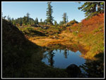
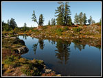
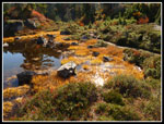
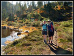
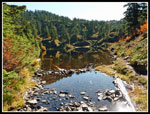
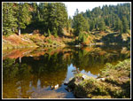
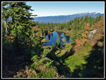
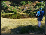
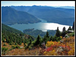
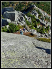
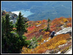
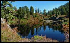
The roots and wet rocks, slippery leaves and big steps grew tiresome but all was forgotten when we crested the ridge. It was just as beautiful as I remembered from my four earlier visits. Gwen was waiting at the first tarn. She had camped on a ridge top above the largest lake. We had good color much of the way up but it was even better around the lakes. After a break we headed on. I recalled one very slick short descent and it was just as slick as I recalled. We crossed the largest lake outlet and hiked along the shore. The total lack of wind that brought on the fog in the lowlands was evident in the glass like reflections on the lakes. Lots more photos along here. We climbed up above the lake and found the main trail once again. There are many short paths to campsites and social trails. In a few spots the main trail was not that obvious.
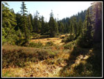
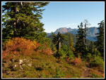
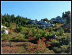
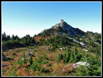
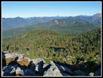
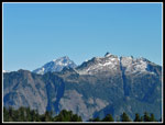
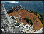
Once above the lakes the route became very clear. it meanders along with a very gentle grade. In meadow then forest and meadow again. Great views down to the lakes below. Views out to Mts. Pilchuck, Three Fingers, Big Four and more. The summit of Bald Mountain was in sight much of the way. The afternoon sun backlit the leaves much of the way. Very bright colors. One of my favorite parts is the meadow with big white granite boulders. Very scenic. We came to the old sign now laying on the ground. Cutthroat Lakes behind us, Bald Mountain and Ashland Lakes to the right. No sign pointing to the third trail heading to the old trailhead off the Williamson Creek Road. That road is no longer open.
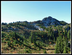
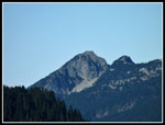
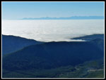
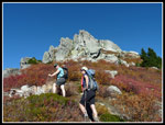
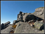
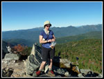
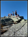
The trail dropped down to the low point in the ridge. More old signs. One noted it was at a helicopter landing area. The trail then cuts to the south side of Bald Mountain. We were in for a surprise. Spada Lake was right below us in the sunshine. most everything to the west was under a low cloud cover. The clouds were blindingly white as the sun shone off of them. The trail traverses to under the summit. No forest here just a sea of colorful leaves. A few switchbacks and we arrived at the ridge coming down off the summit. There was not much of a track on my first visit back in 2003. I had to scramble all around to find a way up. now there is a boot path leading over to the east ridge to our right. Several folks were coming down and another group was heading up. The scramble is short and steep. The rock is very sticky providing good grip. A few minutes later we were on the summit. Two guys were already there. One had a small dog who had no trouble with the scramble up. The other was Mathias who also posts trip reports on the Washington Trails Association site.
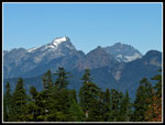
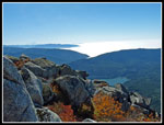
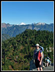
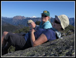
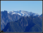
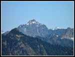
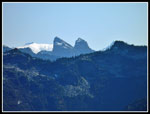
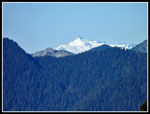
It was 1:35 when I reached the summit. The views were outstanding. From Mt. Rainier and peaks of the Cascade Crest to the south to Mt. Shuksan far to the north. This is the one place I have been to where the south sides of Big Four, and Vesper are seen close by. Glacier Peak had a fresh coat of snow. White Chuck, Pugh, Sloan Peak, and Columbia Peak were in sight. A great viewpoint considering the relatively low elevation of 4581'. We headed down at 2:25 pm, having spent 50 minutes on top. The trip down to the lakes went pretty fast. Gwen packed up her camp while Kim and I lazed around in the sun at the last tarn before the descent from the lakes. A number of groups headed out. In fact, we were the last to leave. it is pretty dark by 6:30 pm these days.
When Gwen arrived we headed down out of the sunshine. The north facing slope is all shade. The descent is not kind to knees. Not a lot faster than the ascent. On my October visit on an after work hike we made it out right at 7:00 pm as the last light slipped away. This day was shaping up similarly. We had one food break at the biggest meadow. Still nice color in the fading light. We just avoided headlamps as we reached the car as 6:50 pm.
This was a great hike. We were in warm sunshine most of the day. Colors may have been a little past prime but were still very nice. The thick bugs at the lakes in the summer were non existent. Fun to look down on the low fog/cloud cover that enveloped the Puget Sound basin in a cold dark funk. We had great views from the summit and short sleeves weather in late October near 5000'. The trail is not smooth and easy but it goes through great scenery and is well worth the effort. It was a great day to be in the mountains.
Click on thumbnails to get
larger pictures.
Trips - 2013
Home
The Walt Bailey Trail up to the Cutthroat Lakes is a volunteer built route. It is rooty and rocky and often muddy. Poles were very helpful in keeping me on my feet. Rather than a climb to the top it is a series of ups and downs, dark forest and open meadows. The numerous big and small meadows are a highlight of this trip. The bright red leaves were missing on this trip but there was a lot of bright yellow and orange. We made consistent progress though I took a whole lot of photos. One faster group passed on by. The route drops down into a valley and crosses to the far side. It was quite cold down there as the sun hardly touches it this time of year. The trail contours along the side of the valley dropping down to 3350' before beginning the climb up to the lakes.
There is a 2 mile marker on a tree near the start of the climb. The trail is rocky with a number of slick old steps. There is one switchback where a tree has fallen across the trail. It is not too hard to get around. The first climb ends at a large bench in the hillside. More meadows and forest. We met a group coming down here. They mentioned that it was not very cold the night before. With clear sky I expected it might freeze. Not the case. Once across the flats the trail traverses a talus field as it climbs once again. The temperature seemed to increase by at least ten degrees as we ascended. Sleeves were rolled up. I kept my pants legs zipped on until we reached the first tarn though I was sweating by then.
The roots and wet rocks, slippery leaves and big steps grew tiresome but all was forgotten when we crested the ridge. It was just as beautiful as I remembered from my four earlier visits. Gwen was waiting at the first tarn. She had camped on a ridge top above the largest lake. We had good color much of the way up but it was even better around the lakes. After a break we headed on. I recalled one very slick short descent and it was just as slick as I recalled. We crossed the largest lake outlet and hiked along the shore. The total lack of wind that brought on the fog in the lowlands was evident in the glass like reflections on the lakes. Lots more photos along here. We climbed up above the lake and found the main trail once again. There are many short paths to campsites and social trails. In a few spots the main trail was not that obvious.
Once above the lakes the route became very clear. it meanders along with a very gentle grade. In meadow then forest and meadow again. Great views down to the lakes below. Views out to Mts. Pilchuck, Three Fingers, Big Four and more. The summit of Bald Mountain was in sight much of the way. The afternoon sun backlit the leaves much of the way. Very bright colors. One of my favorite parts is the meadow with big white granite boulders. Very scenic. We came to the old sign now laying on the ground. Cutthroat Lakes behind us, Bald Mountain and Ashland Lakes to the right. No sign pointing to the third trail heading to the old trailhead off the Williamson Creek Road. That road is no longer open.
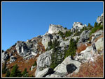
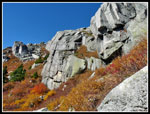
The trail dropped down to the low point in the ridge. More old signs. One noted it was at a helicopter landing area. The trail then cuts to the south side of Bald Mountain. We were in for a surprise. Spada Lake was right below us in the sunshine. most everything to the west was under a low cloud cover. The clouds were blindingly white as the sun shone off of them. The trail traverses to under the summit. No forest here just a sea of colorful leaves. A few switchbacks and we arrived at the ridge coming down off the summit. There was not much of a track on my first visit back in 2003. I had to scramble all around to find a way up. now there is a boot path leading over to the east ridge to our right. Several folks were coming down and another group was heading up. The scramble is short and steep. The rock is very sticky providing good grip. A few minutes later we were on the summit. Two guys were already there. One had a small dog who had no trouble with the scramble up. The other was Mathias who also posts trip reports on the Washington Trails Association site.
It was 1:35 when I reached the summit. The views were outstanding. From Mt. Rainier and peaks of the Cascade Crest to the south to Mt. Shuksan far to the north. This is the one place I have been to where the south sides of Big Four, and Vesper are seen close by. Glacier Peak had a fresh coat of snow. White Chuck, Pugh, Sloan Peak, and Columbia Peak were in sight. A great viewpoint considering the relatively low elevation of 4581'. We headed down at 2:25 pm, having spent 50 minutes on top. The trip down to the lakes went pretty fast. Gwen packed up her camp while Kim and I lazed around in the sun at the last tarn before the descent from the lakes. A number of groups headed out. In fact, we were the last to leave. it is pretty dark by 6:30 pm these days.
When Gwen arrived we headed down out of the sunshine. The north facing slope is all shade. The descent is not kind to knees. Not a lot faster than the ascent. On my October visit on an after work hike we made it out right at 7:00 pm as the last light slipped away. This day was shaping up similarly. We had one food break at the biggest meadow. Still nice color in the fading light. We just avoided headlamps as we reached the car as 6:50 pm.
This was a great hike. We were in warm sunshine most of the day. Colors may have been a little past prime but were still very nice. The thick bugs at the lakes in the summer were non existent. Fun to look down on the low fog/cloud cover that enveloped the Puget Sound basin in a cold dark funk. We had great views from the summit and short sleeves weather in late October near 5000'. The trail is not smooth and easy but it goes through great scenery and is well worth the effort. It was a great day to be in the mountains.
 Starting Up Trail |
 Muddy Trail |
 Mushroom |
 Meadow |
 Berry Bushes |
 Boardwalk |
 Lower Valley |
 More Fall Color |
 Yellow & Green |
 Talus Field |
 Kim On The Rocks |
 Blow Downs |
 More Color |
 Pearly Everlasting |
 Into The Basin |
 Perfect Reflection |
 First Tarn |
 Gwen Lit Up |
 Terrific Color |
 Kim & Gwen |
 Big Lake Outlet |
 Lake Reflection |
 Climbing Above Lakes |
 Three Fingers |
 Summit In Sight |
 Mt. Pilchuck |
 Small Pond |
 High Meadow |
 On Ridge Top |
 White Chuck Mountain |
 South Side Of Peak |
 Great Contrast |
 Great Colors |
 Spada Lake |
 Sea Of Clouds |
 Clouds Up To Mountains |
 Heading For The Summit |
 Final Rock Scramble |
 Summit Is Just Above |
 Looking Down From Top |
 Gwen & Glacier Peak |
 Group Summit Shot |
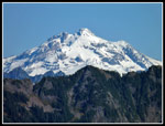 Glacier Peak |
 Cutthroat Lakes |
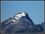 Three Fingers Summit |
 Columbia Peak |
 Sloan & Vesper Peaks |
 Gwen On Summit |
 Mt. Pugh |
 Color Below Summit |
 Heading Down |
 Nearly Back To Trail |
 Mt. Hinman & ? |
 Mt. Shuksan |
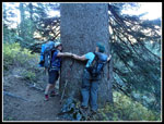 Tree Huggers |
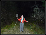 Back At Dark |
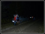 Happy Hikers |
 Cutthroat Lake Panorama |
Trips - 2013
Home