12-31-13
Almost
every year I finish with a hike on Tiger Mountain. This tradition began
in 1983 and has continued with only one exception for the last 31
years. This year Gary and John joined me. The previous three days I did
two Tiger hikes covering much of the north, east, and west sides of the
mountain. Gary proposed a one way trip across the south end. And so it
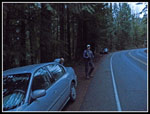
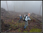
went. We started from the south end of the Tiger Mountain Trail (TMT)
at 8:00 am. I was surprised to see one car already there. We did not
see the owner all day. In fact, we saw only one person until the last
few hundred feet of trail. This is not a crowded side of the mountain.
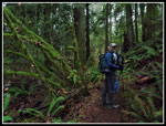
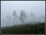
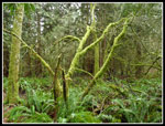
We hiked 1.3 miles up the TMT to Hobart Gap. We took the shorter hiker leg vs. the horse trail. A short jog left then steeply up the road on the South Tiger Traverse. There are still no info at the Gap but the base of the road finally has a sign for the Traverse. After the power line corridor we reentered forest. This section can be overgrown. With leaves off and ferns dead it still looked like some brushing had been done. Very easy walking.
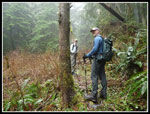
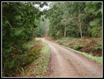
Just before entering the recent clear cut we found the side trail heading up South Tiger. The boot path leading towards the other South Tiger summit has grown into a trail. No problems following it all the way down to the road between peaks. That road has narrowed in just a few years to a path. It leads up to the top of the northern South Tiger summit. This was Gary's first visit since the peak was scalped. He will have to believe me that Mt. Si and East Tiger are in view. This day we saw gray all around us. We dropped down the road all the way to the junction with the TMT near Otter Lake. A short walk brought us to the West Side Road. When John and I hiked through here on the last day of 2011 there was some logging to our right. Now their is logging all around the TMT. We hiked in a little forest and a lot the edge of the clear cut to the junction with the Artifacts Trail. We followed the grade a short way to the creek crossing.
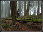
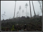
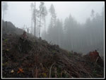
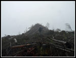
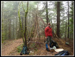
Gary had planned to follow a trail on the GPS map up nearby Karl's Peak. I have been at this place more than a dozen times over the years and never saw or heard about a trail. Yep, it's there. At least the bottom of it is still there. We followed the Karl's Peak Trail up to the clear cut. The trail is now lost under a hillside of slash. In fact, a better name for the peak now is Karl's /pile. We wallowed in the slash as we found a way to climb up the short distance to the top. We met a road higher up and it ended. One last climb up the slash. The top has two big piles of slash and a road. John tried to climb the highest pile but it was a mess of wet logs and branches. Very easy to slip or fall into a void and hurt yourself. He had the common sense to leave the last 20 feet for a dry day.
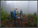
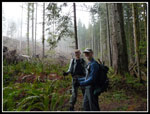
No views from the misty top so we quickly dropped back down. This is one of the few named bumps on Tiger I had not been atop. Until this day. Back at the creek the Artifacts Trail is buried under a number of big logs as it climbs the slope. We chose to climb straight up and avoid the downed trees. At the top we found the trail once again. Two years earlier John and I had no trouble following the Artifacts Trail through the new clear cut. The Cut is now larger and there is slash all over the trail. We were going to give up and head back to the TMT when Gary and John spotted a new road. we headed over there and checked our position on the GPSs. They showed the road winding around and meeting up with the Artifacts Trail farther along. We followed the road and headed off on the Artifacts Trail again. There were a number of trees down but we were able to follow the route.
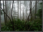
The trail had some very wet sections but we continued on to the top of Middle Tiger. A recent trip report mentioned a "tepee frame" on the summit. It was less impressive than hoped for. Imagine a few dozen long narrow branches forming a conical shape. Three quarters of it is still wide open. We had lunch on the top. It was in the high 30s at 2600' with dripping trees. Very chilly. The way down was almost entirely downhill. A fast half mile to the TMT and another mile down to the West Side Road. Some road walking and we were done. The whole day was walking in clouds and mist. There was a lot of dripping off the trees. I'm not sure if it ever did rain.
The day had more elevation gain than we were planning for. Several hundred feet up Karl's /pile and a deceptively big 600' drop from South Tiger. All totally the two GPSs agreed closely on about 9.4 miles and 3100' of gain. This was my 30th year end hike on Tiger. Something tells me I'll be back next New Year's Eve.
Click on thumbnails to get
larger pictures.
Trips - 2013
Home
We hiked 1.3 miles up the TMT to Hobart Gap. We took the shorter hiker leg vs. the horse trail. A short jog left then steeply up the road on the South Tiger Traverse. There are still no info at the Gap but the base of the road finally has a sign for the Traverse. After the power line corridor we reentered forest. This section can be overgrown. With leaves off and ferns dead it still looked like some brushing had been done. Very easy walking.
Just before entering the recent clear cut we found the side trail heading up South Tiger. The boot path leading towards the other South Tiger summit has grown into a trail. No problems following it all the way down to the road between peaks. That road has narrowed in just a few years to a path. It leads up to the top of the northern South Tiger summit. This was Gary's first visit since the peak was scalped. He will have to believe me that Mt. Si and East Tiger are in view. This day we saw gray all around us. We dropped down the road all the way to the junction with the TMT near Otter Lake. A short walk brought us to the West Side Road. When John and I hiked through here on the last day of 2011 there was some logging to our right. Now their is logging all around the TMT. We hiked in a little forest and a lot the edge of the clear cut to the junction with the Artifacts Trail. We followed the grade a short way to the creek crossing.
Gary had planned to follow a trail on the GPS map up nearby Karl's Peak. I have been at this place more than a dozen times over the years and never saw or heard about a trail. Yep, it's there. At least the bottom of it is still there. We followed the Karl's Peak Trail up to the clear cut. The trail is now lost under a hillside of slash. In fact, a better name for the peak now is Karl's /pile. We wallowed in the slash as we found a way to climb up the short distance to the top. We met a road higher up and it ended. One last climb up the slash. The top has two big piles of slash and a road. John tried to climb the highest pile but it was a mess of wet logs and branches. Very easy to slip or fall into a void and hurt yourself. He had the common sense to leave the last 20 feet for a dry day.
No views from the misty top so we quickly dropped back down. This is one of the few named bumps on Tiger I had not been atop. Until this day. Back at the creek the Artifacts Trail is buried under a number of big logs as it climbs the slope. We chose to climb straight up and avoid the downed trees. At the top we found the trail once again. Two years earlier John and I had no trouble following the Artifacts Trail through the new clear cut. The Cut is now larger and there is slash all over the trail. We were going to give up and head back to the TMT when Gary and John spotted a new road. we headed over there and checked our position on the GPSs. They showed the road winding around and meeting up with the Artifacts Trail farther along. We followed the road and headed off on the Artifacts Trail again. There were a number of trees down but we were able to follow the route.
The trail had some very wet sections but we continued on to the top of Middle Tiger. A recent trip report mentioned a "tepee frame" on the summit. It was less impressive than hoped for. Imagine a few dozen long narrow branches forming a conical shape. Three quarters of it is still wide open. We had lunch on the top. It was in the high 30s at 2600' with dripping trees. Very chilly. The way down was almost entirely downhill. A fast half mile to the TMT and another mile down to the West Side Road. Some road walking and we were done. The whole day was walking in clouds and mist. There was a lot of dripping off the trees. I'm not sure if it ever did rain.
The day had more elevation gain than we were planning for. Several hundred feet up Karl's /pile and a deceptively big 600' drop from South Tiger. All totally the two GPSs agreed closely on about 9.4 miles and 3100' of gain. This was my 30th year end hike on Tiger. Something tells me I'll be back next New Year's Eve.
 Starting At Sunrise |
 Dark Forest |
 South Tiger Summit |
 Bald South Tiger Mt. |
 Trees & Mist |
 Edge Of Clear Cut |
 Karl's /Pile |
 Ascending Karl's Peak |
 Bright Tree |
 John Ascending |
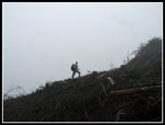 Gary Ascending |
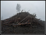 Karl's Summit |
 Descending |
 Artifacts Trail |
 Middle Tiger Summit |
 More Dark Forest |
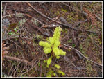
 Mossy Green |
 West Side Road |
Trips - 2013
Home