7-28-13
Gary
was free for the weekend. We kicked around backpacking and day hiking
ideas. I tossed out several places I had not been to in a long time or
ever. Gary latched onto a trip we had each done a number o times but a
different way of doing it. It had been 15 years since my last visit to
Spray Park. Gary was on that trip. I was aware of the unofficial trail
over Knapsack Pass but had not done it. Neither had Gary. John was
available for a Sunday trip so the pieces all fell together. I was up
at 5:00 am and met Gary and John in Kent at 6:25 am. Our early start
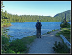
had us at 4929' Mowich Lake by 8:00 am. There were already a lot of
cars there. Lots of tents in the campgrounds. A cloud layer came in
overnight and we were under gray for most of the drive. As we drove
higher the clouds parted and it was clear at the lake. It was also a
little chilly as the thermometer read 47 degrees. With the reports of
bad bugs I was fine with long steeves and long parts.
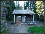
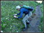
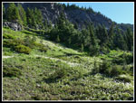
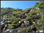
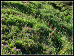
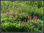
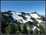
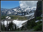
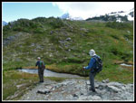
Rather than joining the teaming masses on the trail to Spray Park we headed for the patrol cabin on the lake shore and picked up the trail to Knapsack Pass there. I was expecting a steep rutted climbers track straight up 1300' to the pass. I received far more than I expected. The tread is narrow and muddy in spots. It is easy enough to follow. The route moved from one small meadow to the next. Small waterfalls were all along the route. Higher up wildflowers took off. We took a long time to reach the pass as there was so much to photograph. The flower show is not on a par with Spray Park. The distance is short to the pass. Most folks won't and shouldn't head to the pass vs. Spray Park. Still, it was much more scenic than I was expecting.
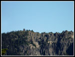
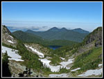
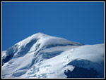
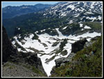
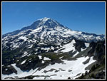
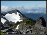
There was a little snow on the route but it will be gone in a week or so. Shortly below the pass we found the boot path heading off towards Fay Peak. After a little discussion we chose to continue to the pass and head to First Mother Mountain instead. Several groups had passed us as we slowly worked our way to the pass. At Knapsack Pass we met a couple who passed us and went on towards First Mother. Below we saw the other group. They descended the pass and were heading on snow over towards Spray Park. From the pass you can see half of Mt. Rainier. A large rock blocks the other half. Great views down to Mowich Lake on one side and parklands on the other. It was already 9:53 am when we reached the 6200' pass. A very slow hike of a little under two miles.
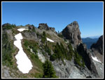
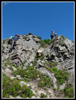
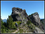
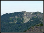
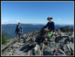
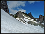
After a food and water break we headed off on the climbers trail to 6480' First Mother Mountain. It traverses a short way then heads steeply up the grassy slope to the ridge top. The terrain ahead looks impossible but a trail winds up, down, and around a number of problem areas. There was just one short exposed spot. The summit is plenty large enough for three hikers. The drop off the south side is near vertical. Great views to Mt. Stuart and Glacier Peak to the north. Mt. Rainier right in your face. Castle Peak to the northwest. John first mentioned the wispy clouds that were moving towards us. An unexpected change was literally in the air.
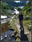
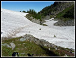
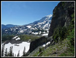
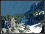
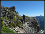
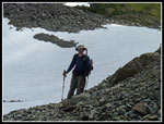
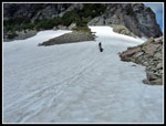
We scrambled back down to Knapsack Pass. The trail down the east side started with switchbacks then began to disintegrate. It drops into loose rocks. The route is still easy to follow but becomes steeper and looser. At the bottom we transitioned to snow. We traversed across a snowy slope. In addition to the two folks we had seen crossing the snow earlier we also saw a group of five while we were coming back from First Mother. The seven folks stomped out steps across the snow. The run out below was fine. A slip would have meant a slog back up the slope but not serious injury. We left the trail when we reached dirt once again. Instead, we headed farther east to get a view down to Mist Park. The flat parkland led us to a very steep drop to Mist Park. We had discussed dropping down, crossing Mist Park and climbing back up to the trail as it ascended to Spray Park. This would be longer and require much more elevation gain. What was not clear is if there was a way all the way down on reasonable terrain. We mulled a route while enjoying some terrific scenery. Taking into account the uncertainty of the route down and the fact it was already 12:50 pm, we chose to take the safe bet and continue on the higher route to Spray Park. Looking back from Spray Park later we concluded the route likely did work.
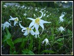
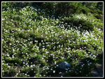
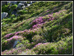
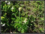
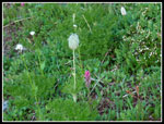
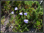
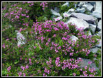
We crossed rock slabs and then headed up snow to the tracks laid down earlier in the day. The snow was softening and the slope we traversed was not all that steep but we brought ice axes so we used them. A mostly level traverse brought us to dirt and the summer way trail. It went back under snow as we had one short steeper climb to the ridge top. The other side of the ridge dropped to Spray Park and was almost snow free. This route took us to a corner of Spray Park that none of us had visited. We were in Spray Park and had only passed two groups of hikers all day. The flower show was good and in many places great. Lots of avalanche lilies in bloom. Magenta Indian paintbrush, cinquefoil, shooting stars, white and purple heather among quite a variety of wildflowers. By now the blue sky had turned to white. No more views of Mt. Rainier this day. There was still snow around in the basin but the trails were mostly bare. We headed higher to where the trail begins to drop to Seattle Park. More good views of Mist Park along the way.
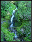
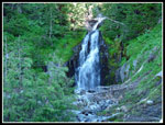
The trip down started slow as there were so many blooming wildflowers to enjoy and photograph. The expected crowds began to materialize though not nearly as large as I was expecting. The flower show is near its peak but the hiker numbers were less than at their peak. Not that I'm complaining. When the meadows gave way to forest we finally picked up our pace. We did take one detour on the way down to have a look at Spray Falls. The white sky above white water detracted from photos. From there the last two miles seemed to take a long time. Lots of ups and downs on the way back. We reached the parking lot just after 5:00 pm. There were a number of cars parked down the road but not as many as I would have expected.
This proved to be a great trip. A new and very beautiful section of trail. A scramble summit. Some off trail and on snow travel. Finally, the great flower show in Spray Park. Doing the trip as a loop was much more fun than the in and out on the Spray Park Trail. The loop is definitely not for everybody. There is some steep down climbing from Knapsack Pass, snow travel, and route finding needed. If the snow was hard it would have been much more difficult. Best for those adept at off trail backcountry travel. It's hard to believe I let 15 years slip by between visits to Spray Park. It deserves its popularity.
Rather than joining the teaming masses on the trail to Spray Park we headed for the patrol cabin on the lake shore and picked up the trail to Knapsack Pass there. I was expecting a steep rutted climbers track straight up 1300' to the pass. I received far more than I expected. The tread is narrow and muddy in spots. It is easy enough to follow. The route moved from one small meadow to the next. Small waterfalls were all along the route. Higher up wildflowers took off. We took a long time to reach the pass as there was so much to photograph. The flower show is not on a par with Spray Park. The distance is short to the pass. Most folks won't and shouldn't head to the pass vs. Spray Park. Still, it was much more scenic than I was expecting.
There was a little snow on the route but it will be gone in a week or so. Shortly below the pass we found the boot path heading off towards Fay Peak. After a little discussion we chose to continue to the pass and head to First Mother Mountain instead. Several groups had passed us as we slowly worked our way to the pass. At Knapsack Pass we met a couple who passed us and went on towards First Mother. Below we saw the other group. They descended the pass and were heading on snow over towards Spray Park. From the pass you can see half of Mt. Rainier. A large rock blocks the other half. Great views down to Mowich Lake on one side and parklands on the other. It was already 9:53 am when we reached the 6200' pass. A very slow hike of a little under two miles.
After a food and water break we headed off on the climbers trail to 6480' First Mother Mountain. It traverses a short way then heads steeply up the grassy slope to the ridge top. The terrain ahead looks impossible but a trail winds up, down, and around a number of problem areas. There was just one short exposed spot. The summit is plenty large enough for three hikers. The drop off the south side is near vertical. Great views to Mt. Stuart and Glacier Peak to the north. Mt. Rainier right in your face. Castle Peak to the northwest. John first mentioned the wispy clouds that were moving towards us. An unexpected change was literally in the air.
We scrambled back down to Knapsack Pass. The trail down the east side started with switchbacks then began to disintegrate. It drops into loose rocks. The route is still easy to follow but becomes steeper and looser. At the bottom we transitioned to snow. We traversed across a snowy slope. In addition to the two folks we had seen crossing the snow earlier we also saw a group of five while we were coming back from First Mother. The seven folks stomped out steps across the snow. The run out below was fine. A slip would have meant a slog back up the slope but not serious injury. We left the trail when we reached dirt once again. Instead, we headed farther east to get a view down to Mist Park. The flat parkland led us to a very steep drop to Mist Park. We had discussed dropping down, crossing Mist Park and climbing back up to the trail as it ascended to Spray Park. This would be longer and require much more elevation gain. What was not clear is if there was a way all the way down on reasonable terrain. We mulled a route while enjoying some terrific scenery. Taking into account the uncertainty of the route down and the fact it was already 12:50 pm, we chose to take the safe bet and continue on the higher route to Spray Park. Looking back from Spray Park later we concluded the route likely did work.
We crossed rock slabs and then headed up snow to the tracks laid down earlier in the day. The snow was softening and the slope we traversed was not all that steep but we brought ice axes so we used them. A mostly level traverse brought us to dirt and the summer way trail. It went back under snow as we had one short steeper climb to the ridge top. The other side of the ridge dropped to Spray Park and was almost snow free. This route took us to a corner of Spray Park that none of us had visited. We were in Spray Park and had only passed two groups of hikers all day. The flower show was good and in many places great. Lots of avalanche lilies in bloom. Magenta Indian paintbrush, cinquefoil, shooting stars, white and purple heather among quite a variety of wildflowers. By now the blue sky had turned to white. No more views of Mt. Rainier this day. There was still snow around in the basin but the trails were mostly bare. We headed higher to where the trail begins to drop to Seattle Park. More good views of Mist Park along the way.
The trip down started slow as there were so many blooming wildflowers to enjoy and photograph. The expected crowds began to materialize though not nearly as large as I was expecting. The flower show is near its peak but the hiker numbers were less than at their peak. Not that I'm complaining. When the meadows gave way to forest we finally picked up our pace. We did take one detour on the way down to have a look at Spray Falls. The white sky above white water detracted from photos. From there the last two miles seemed to take a long time. Lots of ups and downs on the way back. We reached the parking lot just after 5:00 pm. There were a number of cars parked down the road but not as many as I would have expected.
This proved to be a great trip. A new and very beautiful section of trail. A scramble summit. Some off trail and on snow travel. Finally, the great flower show in Spray Park. Doing the trip as a loop was much more fun than the in and out on the Spray Park Trail. The loop is definitely not for everybody. There is some steep down climbing from Knapsack Pass, snow travel, and route finding needed. If the snow was hard it would have been much more difficult. Best for those adept at off trail backcountry travel. It's hard to believe I let 15 years slip by between visits to Spray Park. It deserves its popularity.
GPS
Map Of Route
Click on thumbnails to get
larger pictures.
Photo Page 2
Trips - 2013
Home
 Mowich Lake |
 Ranger Station |
 Tolmie Peak Lookout |
 Cascade |
 Avalanche Lilies |
 Gary At Work |
 Waterfall |
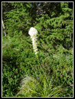 Beargrass |
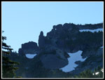 Rock Pinnacles |
 Sunlit Flowers |
 Avy Lily Carpet |
 Gary On Trail |
 Rock Garden |
 Great Colors |
 Crossing Snow Patch |
 Blooming Heather |
 Light & Shadows |
 Indian Paintbrush |
 Western Anemone |
 Shaggy Anemone |
 View Of Route Up |
 Half Of Mt. Rainier |
 Harebells |
 Mt. Rainier Summit |
 Fay Peak |
 Scramble Route |
 Scrambling Up |
 Summit On Right |
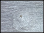 Goat |
 Snowy Basin |
 Mt. Rainier |
 Eunice Lake & Tolmie Pk |
 Fay From Mother |
 John & Gary On Top |
 Lake Below |
 Exposed Spot |
 Clouds Roll In |
 More Heather |
 Gary Below Knapsack |
 Looking Back To Pass |
 Glissading |
 Crossing Meadow |
Photo Page 2
Trips - 2013
Home