6-09-13
Gary
and I did a snow scramble up Tamanos Mountain back in 2000. That was
before my website. I did not take a film camera along. It was a
beautiful sunny day and I regretted not having any photos. Thirteen
years later it was time to rectify my mistake. John joined us for this
trip. I was out the door at 6:00 am and picked up Gary and John in
Kent. We headed out Highway 410 to the White River entrance to Mt.
Rainier National Park. The forecast was for all day sunshine... when I
went to bed. In the morning it had changed to "mostly cloudy". It was
very cloudy in Seattle but there was some clearing at the trailhead. We
were the only car in the lot at 8:00 am. I was a little surprised to
see a park trails update that said the first two miles were snow free.
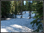
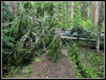
There was no snow at the 3750' trailhead. There are some downed trees
across the trail. Most of them are in the first quarter mile.
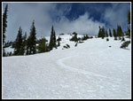
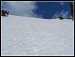
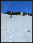
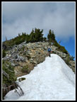
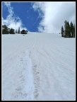
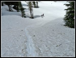
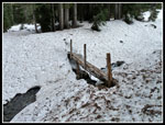
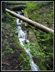
This is a very gently graded trail to Owyhigh Lakes. It is 3 1/2 miles to the lakes gaining about 1500'. The last 1.2 miles up Tamanos gains the other half of the elevation. Trillium are out and some skunk cabbage that has not bloomed yet. Add a few yellow violets for all the early season flowers. As the trail switchbacks up the steep slope there were a few snow patches around mile two. Several spots had steep snow across the trail in short stretches. The warm day had the snow soft enough to set solid steps. Warm is relative as my thermometer read about 49 degrees. A little short of three miles the route went from dirt to several feet of snow all at once. At three miles is a log bridge which we found easily enough. Snow on both sides but the log was dry. The wire hand rail is great if you are not tall. I could barely reach down to it.
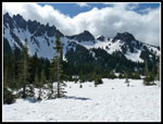
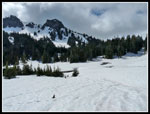
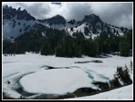
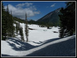
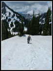
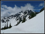
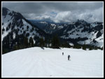
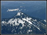
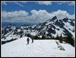
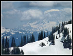
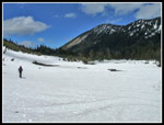
We had been following some faint prints in the snow and they became really faint across the bridge. A glissade track was uphill to our right. We headed that way. That was not correct. The trail actually is fairly level as it goes below the ridge we were ascending. Another check of the map and GPS units and we found our error. We had to drop down the slope to the area of the trail. Other than a few cut logs it was hard to follow as we lost it several times. At this point it does not matter as the valley we were in leads to the lakes. Soon we left the forest and entered the large white basin of Owyhigh Lakes. Above us to the right was Tamanos Mountain. Governors Ridge is on the other side of the valley. A very beautiful spot with all the snow. Some blue sky and big puffy clouds added to the views. The lakes are not very large and covered with snow not that easy to spot. On both my visits the whole basin was under snow.
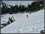
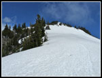
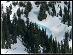
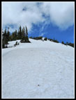
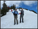
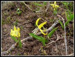
We took a break on a lone bare spot to put on gaiters and sun screen and have a bite to eat. Heading on we came to a spot where a lake/tarn was melting out. Blue snow around the edges with a little open water where a small creek tumbled down. There were some glacier lilies in bloom on a little bare dirt along the shore. We continued straight ahead ascending a short gully. Soon the slopes on our right became a little less steep. We headed uphill following large openings in the forest. From here up to the saddle it was just a fairly steep snow slog. The snow was firm with the top few inches being softer. Very good for kicking steps. We went to ice axes but no traction devices for the climb. Gary led the first part then I took over. The slope never felt all that steep when looking down. Looking up slope it certainly did. Our route angled to our right as the saddle below Tamanos summit came into view.
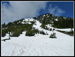
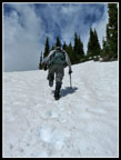
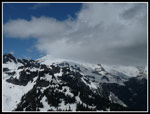
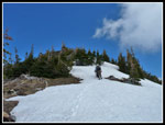
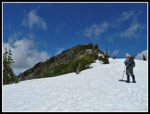
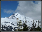
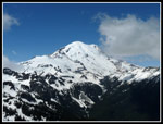
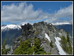
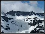
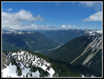
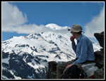
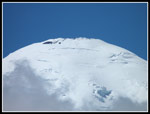
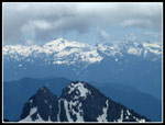
On the steeper slopes to the left of the saddle there were carved ski turns. I preferred the slightly gentler terrain we took. Up at the saddle I saw Mt. Rainier right across from us. Well, I saw the bottom half of Mt. Rainier. The top was awash in clouds. Everything else was in the clear. Cowlitz Chimneys were close by. We could pick out Banshee Peak where we hiked last summer. Goat Island Mountain was to our right. Even Little Tahoma was out of the clouds. Behind us we were no longer looking up at Governors Ridge. It is a short but steep climb from the saddle to the summit of Tamanos. The ridge up was all snow with short krumholtz trees on the crest and dirt on the left side of the ridge. John led the last leg up. As we neared the end of the snow below the summit we noticed a narrow chute below on our right. There were ski tracks at the top. I can't imagine starting down a very steep and very narrow slot like that. It looked to be a two minute route to the lakes below.
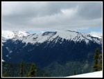
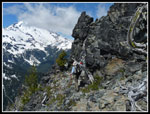
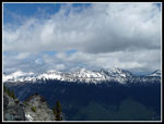
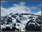
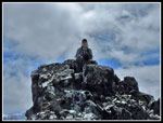
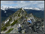
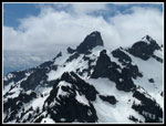
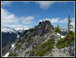
Once off snow it was a short rock and dirt trail hike to the top. The views are outstanding. Well worth the 1700 feet of climbed in 1.2 miles from the lakes. Memories fade over 13 years. I forgot that there is another slightly higher summit a short way down the ridge. We had to go take a look. We dropped down to the ridge and around the left side of the big rock block. There was a faint trail. Around the other side we found a short rock scramble to the top. As I was taking photos I suddenly realized that Rainier was totally out of the clouds. Our patience was rewarded. A short way down the ridge was another summit that looked to be a little higher. We dropped down along the ridge and again found a route to the left. This one led to an easy walk up to the highest point. Only room for one person at the 6790' peak but lots of room just below. We had very clear views of Goat Island Mountain, the road to Sunrise, and a little of Burroughs Mountain. Rainier was going in and out of the clouds as it did for the rest of our stay.
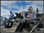
It was now 12:15 pm and we were ready for lunch. The best open spot was back at the first summit and we headed back there. The hike down would be fast. The day was beautiful. We were in no hurry to leave. From reaching the first summit to heading down we spent nearly two hours on top. There was a little wind but it was not bad. An hour went by before we pulled out jackets. Much to our surprise, John pulled off a tick. I did not think they were in MRNP. It was about 1:50 pm when we headed down. There were a few spots above the saddle where we had to really kick steps in hard snow that also had some exposure if you slipped that I though might be a little difficult to descend. They were no problem at all. The snow had softened just enough.
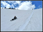
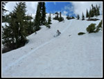
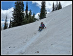
Back at the saddle the real fun began. We put together half a dozen glissades on the way down. A few were short and a few were longer and fast. Glissade season is one of my favorite times of the year. We did not bother putting on rain pants. Wet shorts were a small price to pay for all the fun. It seemed to take no time at all to get back down the the lakes. On our way out we did not see any fresh boot prints. It seems we were the only hikers on the trail all day. After seeing 500 people on my Mt. Si Grape Nuts hike last Saturday I saw 500 less people this day. This is more like most of my hikes.
By 4:20 pm we were back at the trailhead. This was an outstanding spring snow scramble. Nearly 2/3s of the hike was on dirt. The snow was nearly perfect for climbing and glissading. The clouds added to the overall views. Especially as they went in and out allowing clear views of everything at one time or another. It is hard to believe I went 13 years between visits. This will go down as one of the best day trips of the year.
Click on thumbnails to get
larger pictures.
Trips - 2013
Home
This is a very gently graded trail to Owyhigh Lakes. It is 3 1/2 miles to the lakes gaining about 1500'. The last 1.2 miles up Tamanos gains the other half of the elevation. Trillium are out and some skunk cabbage that has not bloomed yet. Add a few yellow violets for all the early season flowers. As the trail switchbacks up the steep slope there were a few snow patches around mile two. Several spots had steep snow across the trail in short stretches. The warm day had the snow soft enough to set solid steps. Warm is relative as my thermometer read about 49 degrees. A little short of three miles the route went from dirt to several feet of snow all at once. At three miles is a log bridge which we found easily enough. Snow on both sides but the log was dry. The wire hand rail is great if you are not tall. I could barely reach down to it.
We had been following some faint prints in the snow and they became really faint across the bridge. A glissade track was uphill to our right. We headed that way. That was not correct. The trail actually is fairly level as it goes below the ridge we were ascending. Another check of the map and GPS units and we found our error. We had to drop down the slope to the area of the trail. Other than a few cut logs it was hard to follow as we lost it several times. At this point it does not matter as the valley we were in leads to the lakes. Soon we left the forest and entered the large white basin of Owyhigh Lakes. Above us to the right was Tamanos Mountain. Governors Ridge is on the other side of the valley. A very beautiful spot with all the snow. Some blue sky and big puffy clouds added to the views. The lakes are not very large and covered with snow not that easy to spot. On both my visits the whole basin was under snow.
We took a break on a lone bare spot to put on gaiters and sun screen and have a bite to eat. Heading on we came to a spot where a lake/tarn was melting out. Blue snow around the edges with a little open water where a small creek tumbled down. There were some glacier lilies in bloom on a little bare dirt along the shore. We continued straight ahead ascending a short gully. Soon the slopes on our right became a little less steep. We headed uphill following large openings in the forest. From here up to the saddle it was just a fairly steep snow slog. The snow was firm with the top few inches being softer. Very good for kicking steps. We went to ice axes but no traction devices for the climb. Gary led the first part then I took over. The slope never felt all that steep when looking down. Looking up slope it certainly did. Our route angled to our right as the saddle below Tamanos summit came into view.
On the steeper slopes to the left of the saddle there were carved ski turns. I preferred the slightly gentler terrain we took. Up at the saddle I saw Mt. Rainier right across from us. Well, I saw the bottom half of Mt. Rainier. The top was awash in clouds. Everything else was in the clear. Cowlitz Chimneys were close by. We could pick out Banshee Peak where we hiked last summer. Goat Island Mountain was to our right. Even Little Tahoma was out of the clouds. Behind us we were no longer looking up at Governors Ridge. It is a short but steep climb from the saddle to the summit of Tamanos. The ridge up was all snow with short krumholtz trees on the crest and dirt on the left side of the ridge. John led the last leg up. As we neared the end of the snow below the summit we noticed a narrow chute below on our right. There were ski tracks at the top. I can't imagine starting down a very steep and very narrow slot like that. It looked to be a two minute route to the lakes below.
Once off snow it was a short rock and dirt trail hike to the top. The views are outstanding. Well worth the 1700 feet of climbed in 1.2 miles from the lakes. Memories fade over 13 years. I forgot that there is another slightly higher summit a short way down the ridge. We had to go take a look. We dropped down to the ridge and around the left side of the big rock block. There was a faint trail. Around the other side we found a short rock scramble to the top. As I was taking photos I suddenly realized that Rainier was totally out of the clouds. Our patience was rewarded. A short way down the ridge was another summit that looked to be a little higher. We dropped down along the ridge and again found a route to the left. This one led to an easy walk up to the highest point. Only room for one person at the 6790' peak but lots of room just below. We had very clear views of Goat Island Mountain, the road to Sunrise, and a little of Burroughs Mountain. Rainier was going in and out of the clouds as it did for the rest of our stay.
It was now 12:15 pm and we were ready for lunch. The best open spot was back at the first summit and we headed back there. The hike down would be fast. The day was beautiful. We were in no hurry to leave. From reaching the first summit to heading down we spent nearly two hours on top. There was a little wind but it was not bad. An hour went by before we pulled out jackets. Much to our surprise, John pulled off a tick. I did not think they were in MRNP. It was about 1:50 pm when we headed down. There were a few spots above the saddle where we had to really kick steps in hard snow that also had some exposure if you slipped that I though might be a little difficult to descend. They were no problem at all. The snow had softened just enough.
Back at the saddle the real fun began. We put together half a dozen glissades on the way down. A few were short and a few were longer and fast. Glissade season is one of my favorite times of the year. We did not bother putting on rain pants. Wet shorts were a small price to pay for all the fun. It seemed to take no time at all to get back down the the lakes. On our way out we did not see any fresh boot prints. It seems we were the only hikers on the trail all day. After seeing 500 people on my Mt. Si Grape Nuts hike last Saturday I saw 500 less people this day. This is more like most of my hikes.
By 4:20 pm we were back at the trailhead. This was an outstanding spring snow scramble. Nearly 2/3s of the hike was on dirt. The snow was nearly perfect for climbing and glissading. The clouds added to the overall views. Especially as they went in and out allowing clear views of everything at one time or another. It is hard to believe I went 13 years between visits. This will go down as one of the best day trips of the year.
 Suddenly Deep Snow |
 Into The Lakes Basin |
 Tamanos Is Above |
 Near Owyhigh Lakes |
 Melting Out |
 Passing Lakes |
 Atop The Gully |
 Kicking Steps |
 Snowboard Tracks |
 John Is Behind Me |
 Chimneys In Clouds |
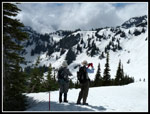 Photo Break |
 Doesn't Seem Any Closer |
 Mountain Scenery |
 Rainier In Clouds |
 Goat Island Mountain |
 On The Summit Ridge |
 Heading Up |
 Bare On Ridge Top |
 Near End Of Snow |
 Rainier Is Clearing |
 Going To Summit Two |
 Sunrise Road |
 Clear View Of Rainier |
 Third Summit |
 Snowy Tarn |
 Banshee Peak |
 Cowlitz Chimneys |
 White River Valley |
 John On High Point |
 Fourth Summit |
 Scramble Route |
 Gary On Summit |
 Rainier Summit |
 John & Gary On Top |
 Cowlitz Close Up |
 Goat Rocks |
 Shriner Peak |
 Second Summit |
 Heading Down |
 Sky High Ridge Walk |
 Looking Back Up |
 Friends? |
 John Glissading |
 Long Track |
 Mt. Adams |
 Action Shot |
 Gary Glissading |
 Last Glissade |
 Crossing Lakes Basin |
 Glacier Lilies |
 Bridge |
 Cascades |
 Downed Trees |
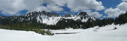 Panorama Of Governors Ridge Above Owyhigh Lakes |
Trips - 2013
Home